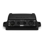
This adapter allows you to connect the wires on legacy 6-pin transducers with newer sonar that require a 8-pin connection.
-8%


Garmin, Garmin Chartplotters, Sanctuary Cove
Price Match
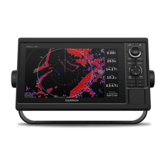
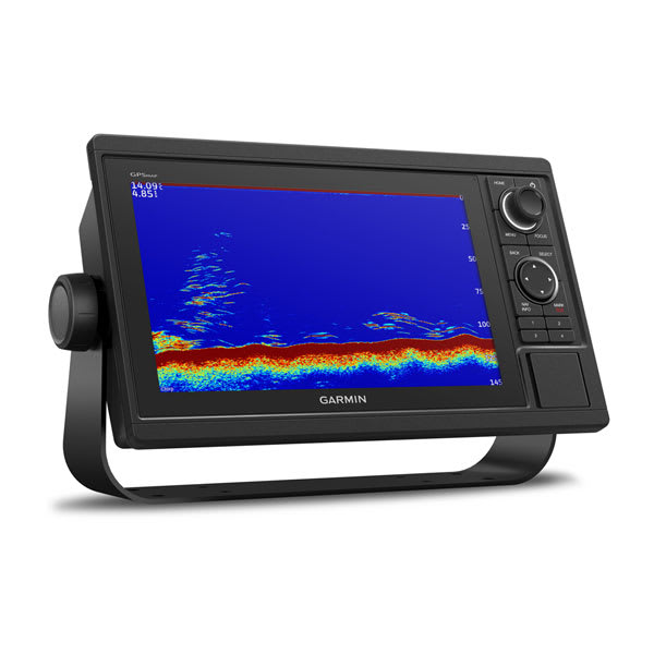
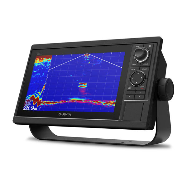
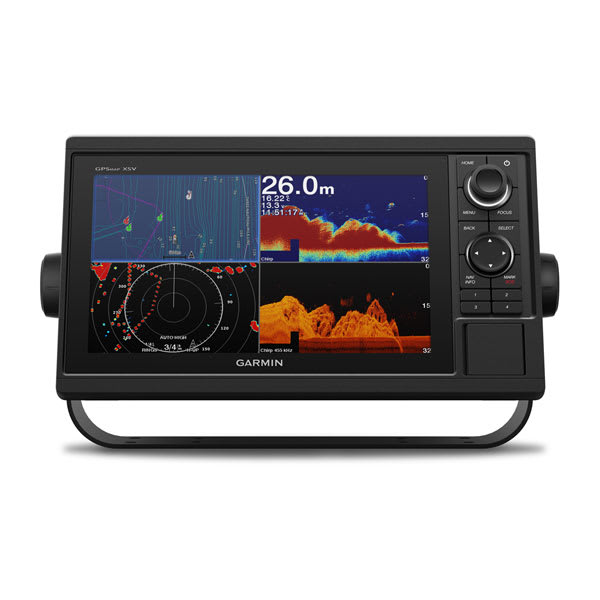
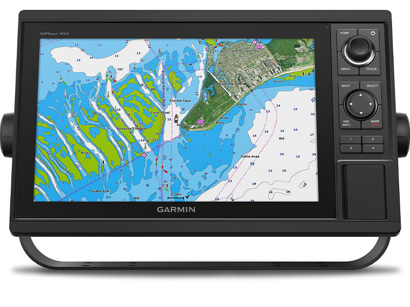
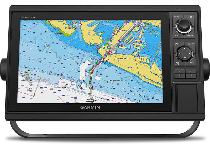
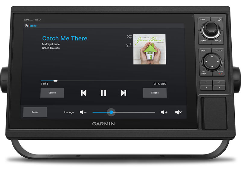
Garmin GPSMAP 1022xsv – Chartplotter without Transducer but with SideVü, ClearVü and Traditional CHIRP Sonar & Worldwide Basemap
Price Match
$2,399.00 $2,599.00
-
Garmin, Garmin Chartplotters, Sanctuary Cove
Garmin GPSMAP 1022xsv – Chartplotter without Transducer but with SideVü, ClearVü and Traditional CHIRP Sonar & Worldwide Basemap
-8%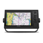 Garmin, Garmin Chartplotters, Sanctuary Cove
Garmin GPSMAP 1022xsv – Chartplotter without Transducer but with SideVü, ClearVü and Traditional CHIRP Sonar & Worldwide Basemap
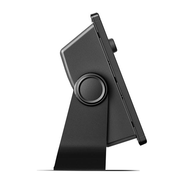
Garmin GPSMAP 1022xsv Chartplotter – without Transducer, but with SideVü, ClearVü and Traditional CHIRP Sonar & Worldwide Basemap.
A PREMIUM CHARTPLOTTER FOR THE ADVENTUROUS SPIRIT
These chartplotters feature large, bright screens coupled with quick and easy-to-use keypad interfaces with user-programmable keys and multifunction control knobs to help you navigate with ease.

Get wider viewing angles on a vivid 10″ or 12″ colour display.

These are compatible with our premium maps and charts for the best in Garmin navigation.

Share information among multiple units, thanks to Garmin Marine Network support.

See fluid position and heading changes with update rates of 10 times per second.

Easily transfer waypoints, tracks and routes from your other GPS devices.

See what’s around your boat with built-in sonar capabilities on select models (transducers sold separately).
SKU: 010-01740-02 -
Garmin, Garmin Accessories
Garmin 9-axis Heading Sensor
Garmin 9-axis Heading Sensor
Premium Solution for Exceptional Heading Accuracy
- Provides exceptional heading accuracy, even at lower speeds or when bow is pitching, rolling or heeling over
- Heading accuracy of plus or minus 2 degrees
- Heading and rate-of-turn output at 10 Hz; trim and heel output at 1 Hz
- Simple 2-step calibration process
- 9-axis MEMS technology allows installation in any orientation located away from magnetic interference
The 9-axis heading sensor is our premium solution that is easy to install and provides fast calibration and exceptional heading accuracy.
Accurate Heading Even at Low Speed
Its heading output at 10 Hz and accuracy of plus or minus 2 degrees ensures your chart orientation and boat heading line match up with reality, even at lower speeds. It also allows for MARPA tracking and improves radar overlay experience.
Effective in Rough Waters
You can also be confident your heading information will remain accurate, even in rough sea conditions where your bow is pitching and rolling or — in sailboat applications — when heeled over. Provides heading and rate-of-turn output at 10 Hz and trim and heel output at 1 Hz.
Easy Installation, Fast Calibration
The 9-axis heading sensor installs easily with NMEA 2000® plug-and-play interface and a simple 2-step precision calibration process for compatible Garmin chartplotters. For displays other than Garmin, basic calibration is also supported. The heading sensor’s 9-axis MEMS technology allows installation in any orientation located away from magnetic interference. All of our heading sensors are built to withstand bilge environments.
What’s in the box?
- 9-axis Heading Sensor
- NMEA 2000® T-connector
- NMEA 2000 drop cable (2 meters)
- Documentation
Installation Instructions
SKU: 010-11417-20
$3,587.00 for 3 item(s)
Garmin GPSMAP 1022xsv Chartplotter – without Transducer, but with SideVü, ClearVü and Traditional CHIRP Sonar & Worldwide Basemap.
A PREMIUM CHARTPLOTTER FOR THE ADVENTUROUS SPIRIT
These chartplotters feature large, bright screens coupled with quick and easy-to-use keypad interfaces with user-programmable keys and multifunction control knobs to help you navigate with ease.
![]() Get wider viewing angles on a vivid 10″ or 12″ colour display.
Get wider viewing angles on a vivid 10″ or 12″ colour display.
![]() These are compatible with our premium maps and charts for the best in Garmin navigation.
These are compatible with our premium maps and charts for the best in Garmin navigation.
![]() Share information among multiple units, thanks to Garmin Marine Network support.
Share information among multiple units, thanks to Garmin Marine Network support.
![]() See fluid position and heading changes with update rates of 10 times per second.
See fluid position and heading changes with update rates of 10 times per second.
![]() Easily transfer waypoints, tracks and routes from your other GPS devices.
Easily transfer waypoints, tracks and routes from your other GPS devices.
![]() See what’s around your boat with built-in sonar capabilities on select models (transducers sold separately).
See what’s around your boat with built-in sonar capabilities on select models (transducers sold separately).

A feature-rich chartplotter.
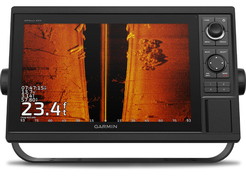
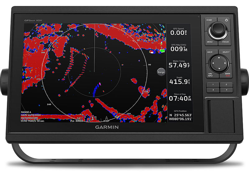
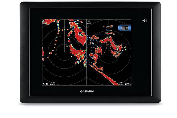
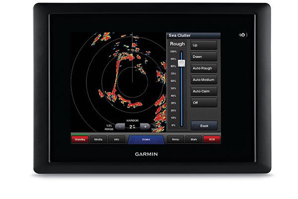
SONAR CAPABLE
The chartplotters include built-in single-channel CHIRP sonar plus CHIRP ClearVü™ and CHIRP SideVü™ scanning sonars with Panoptix™ and LiveScope™ sonar support on select models (transducers sold separately).
BUILT-IN ANT® CONNECTIVITY
Enjoy built-in ANT wireless connectivity directly to your compatible Garmin devices such as quatix® marine watches, gWind™ Wireless 2 transducers , GNX™ Wind marine instruments and wireless remote controls.
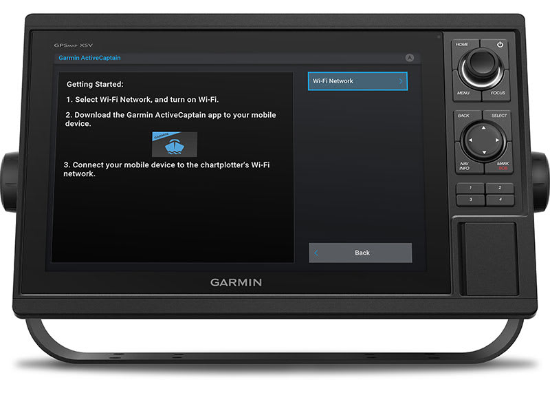
CONNECTED ACTIVECAPTAIN® APP
Built in Wi-Fi® technology gives you access to the free all-in-one ActiveCaptain app, so you can manage your marine experience from nearly anywhere on your compatible smartphone.

Navigate with ease.
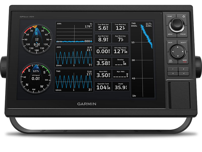
GARMIN SAILASSIST™ FEATURE
Use the polar table to view important data fields to help you trim your sails for maximum speed and efficiency. You can also see laylines, set and drift, true and apparent wind data (sensor sold separately), and more.
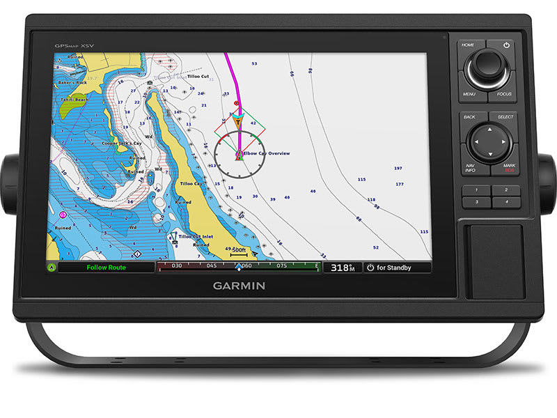
CHARTS AND MAPS
Bring a fresh new look and feel to your chartplotter with optional Garmin Navionics+™ or premium Garmin Navionics Vision+™ cartography featuring integrated coastal/inland content, access to daily updates, Auto Guidance+™ technology1 and more.
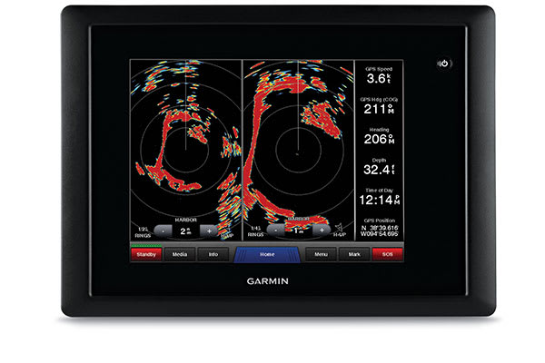
SMOOTH TRACKING
The fast, responsive built-in 10 Hz GPS and GLONASS receiver refreshes your position and heading 10 times each second to make your movement on the screen more fluid.
NETWORK CAPABLE
The GPSMAP chartplotters are fully network capable for the Garmin Marine Network and NMEA 2000® networking plus NMEA 0183 technology support.
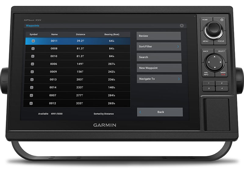
GPX WAYPOINTS TRANSFER
Easily transfer waypoints, tracks or frequently used routes from other devices via industry standard GPX software formatting.
COMPLETE NETWORK SHARING
Garmin Marine Network support allows sharing of sonar, maps, user data, dome or open-array radar, and Panoptix and LiveScope sonars among multiple units.
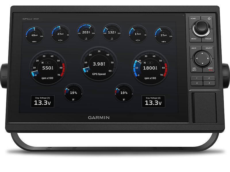
ENGINE CONNECTIVITY
Read RPMs, fuel flow, temperature, trim and other important information at a glance. Check with your engine manufacturer for additional hardware needs.
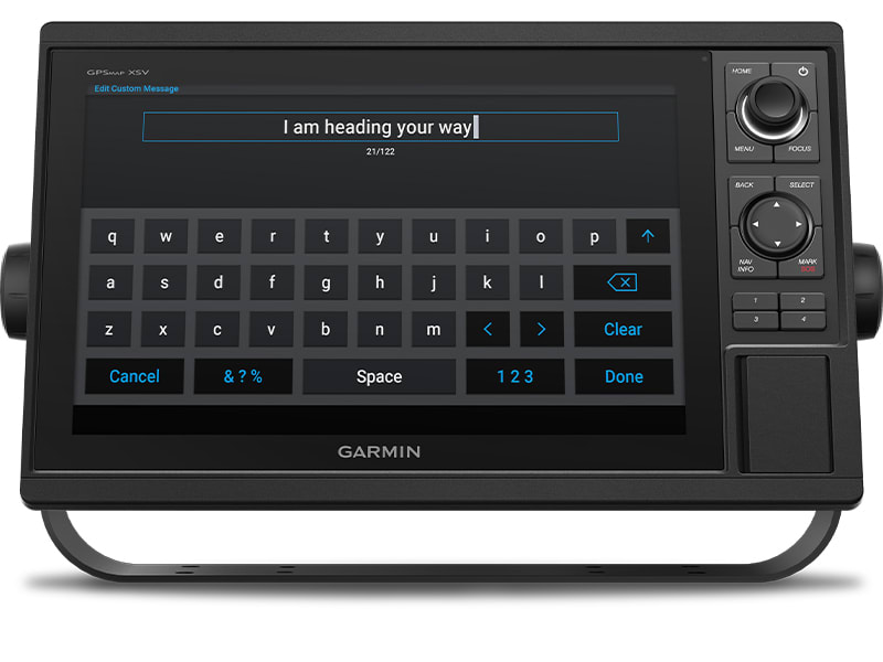
SEND INREACH® DEVICE MESSAGES
Pair your inReach satellite communicator2 to your chartplotter, and type custom messages using your MFD’s on-screen keyboard. Access your contact list or enter an email, inReach address or phone number. You can also group messages by conversation for a texting-like experience.
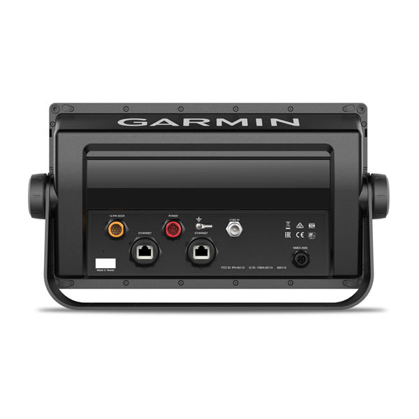
What’s in the box
- GPSMAP 1022xsv chartplotter
- Power/data cable
- NMEA 2000 T-connector
- NMEA 2000 drop cable (2 m)
- 8-pin transducer to 12-pin sounder adapter cable
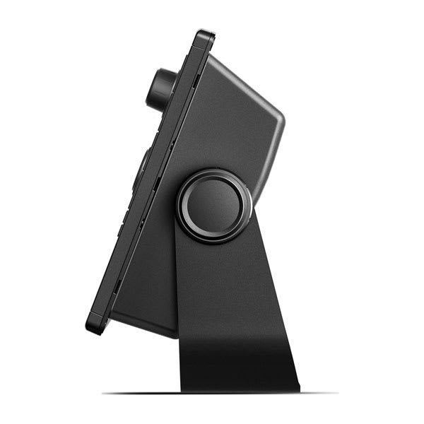
- Bail mount kit with knobs
- Flush mount kit with gasket
- Protective cover
- Trim piece snap covers
- Documentation
View Installation Instructions
View Owner’s Manual
| Weight | 1.9 kg |
|---|
General |
|
| DIMENSION | 12.5″ x 7.3″ x 2.7″ (318 x 185 x 69 mm) |
| WEIGHT |
4.1 lbs (1.85 kg) |
| WATERPROOF |
IPX7 |
| DISPLAY TYPE | WSVGA, NP |
| DISPLAY SIZE | 8.8″ x 4.9″; 10.1″ diagonal (22.4 x 12.5 cm; 25.7 cm diagonal) |
| DISPLAY RESOLUTION | 1024 x 600 pixels |
| MOUNTING OPTIONS | Bail or flush |
| INPUT | Keyed |
Maps & Memory |
|
| ACCEPTS DATA CARDS |
2 SD™ cards |
| WAYPOINTS |
5000 |
| TRACK POINTS | 50,000 |
| TRACKS | 50 saved tracks |
| NAVIGATION ROUTES | 100 |
Sensors |
|
| GPS | ✔ |
| GLONASS | ✔ |
| HAS BUILT-IN RECEIVER | ✔ |
| RECEIVER | ✔ |
| NMEA 2000 COMPATIBLE | ✔ |
| NMEA 0183 COMPATIBLE | ✔ |
| SUPPORTS WAAS | ✔ |
Built-in maps |
|
| TIDE TABLES | ✔ |
Optional map support |
|
| BLUECHART G3 | ✔ |
| BLUECHART G3 VISION | ✔ |
| LAKEVÜ G3 | ✔ |
| LAKEVÜ G3 ULTRA | ✔ |
| GARMIN NAVIONICS+™ | ✔ |
| GARMIN NAVIONICS VISION+™ | ✔ |
| TOPO | ✔ |
| STANDARD MAPPING | ✔ |
| GARMIN QUICKDRAW CONTOURS | ✔ |
| RASTER CHART SUPPORT | ✔ |
Chartplotter Features |
|
| SMART MODE COMPATIBLE | ✔ |
| AIS | ✔ |
| DSC | ✔ |
| SUPPORTS FUSION-LINK™ COMPATIBLE RADIOS | ✔ |
| GSD BLACK BOX SONAR SUPPORT | ✔ |
| GCV BLACK BOX SONAR SUPPORT | ✔ |
| ACTIVECAPTAIN MOBILE PLANNING COMPATIBLE | ✔ |
| GRID (GARMIN REMOTE INPUT DEVICE) COMPATIBLE | ✔ |
| WIRELESS REMOTE COMPATIBLE | ✔ |
| SAILING FEATURES | ✔ |
Electrical features |
|
| POWER INPUT | 10 to 32 Vdc |
| TYPICAL CURRENT DRAW AT 12 VDC | 1.9 A |
| MAXIMUM CURRENT DRAW AT 12 VDC | 2.7 A |
| MAXIMUM POWER USAGE AT 10 VDC | 32.4W |
Sonar Features & Specifications |
|
| DISPLAYS SONAR | ✔ |
| POWER OUTPUT | 1 kW |
| TRADITIONAL SONAR (DUAL FREQUENCY/BEAM) | built-in (single channel CHIRP, 70/83/200 kHz, L, M, H CHIRP) |
| CLEARVÜ | Yes with CHIRP (built-in) |
| SIDEVÜ | Yes with CHIRP (built-in) |
| PANOPTIX™ SONAR | ✔ |
| LIVESCOPE | ✔ |
Connections |
|
| NMEA 2000® PORTS | 1 |
| CONNECTIONS NMEA0183 INPUT PORTS | 1 |
| NMEA 0183 INPUT (TX) PORTS | 1 |
| VIDEO INPUT PORTS |
1 BNC |
| GARMIN MARINE NETWORK PORTS |
2 |
| BLUETOOTH® PAIRING | ✔ |
| ANT+ (CONNECTIVITY) | ✔ |
| GARMIN WI-FI NETWORK (LOCAL CONNECTION) | ✔ |
You may also like…
-
Garmin, Garmin Accessories, Sanctuary Cove
Garmin GPS 24xd NMEA 2000 – White
Garmin GPS 24xd NMEA 2000 – EXPLORE COASTAL WATERS
The GPS 24xd position receiver and antenna gives you precise location with multi-band GNSS and heading accuracy even at slow speeds.

Navigate in more locations with expanded GNSS support.

Get high-sensitivity tracking with fast GPS update rate.

Accurately pinpoint your heading — regardless of speed.

It’s water-resistant (IPX7) to withstand the elements.

Install it easily with multiple mounting options.

The antenna is compatible with NMEA 2000® devices.

More accurate data — for more confident navigation.
MULTI-BAND GNSS
Multi-band GNSS provides precise location accuracy1 to within 1 metre to compatible marine multifunction displays, instrument displays and autopilots.
MAGNETIC HEADING
The magnetic heading sensor provides accuracy to within 3 degrees, stabilising charts, radar overlay and MARPA even at slow speeds.
HIGH-SENSITIVITY GPS
Fast 10 Hz position update rates provide high-sensitivity position, velocity and time data.
EXPANDED GNSS SUPPORT
GPS 24xd provides access to four key global navigation satellite systems (GPS, Galileo2, GLONASS and BeiDou2) to more accurately track in challenging conditions than GPS alone.
MULTI-SBAS COMPATIBLE
Multi-SBAS compatibility corrects signal measurement errors and provides information about the accuracy, integrity, continuity and availability of its signals.
MOUNTING OPTIONS
Installation is easy with under-deck, pole and surface-mount options.
11 < 1 metre CEP, < 3 metres 95%2Supported when available What’s in the box?
- GPS 24xd NMEA 2000®
- Pole mount
- Surface mount
- Under-deck mount
- NMEA 2000 backbone/drop cable (6 metres)
- NMEA 2000 T-connector
- Documentation
Installation Instructions
Setting Up A NMEA Network and Installing a Garmin GPS 24XD on a boat
SKU: 010-02316-10 -
Garmin, Garmin Accessories
Garmin 9-axis Heading Sensor
Garmin 9-axis Heading Sensor
Premium Solution for Exceptional Heading Accuracy
- Provides exceptional heading accuracy, even at lower speeds or when bow is pitching, rolling or heeling over
- Heading accuracy of plus or minus 2 degrees
- Heading and rate-of-turn output at 10 Hz; trim and heel output at 1 Hz
- Simple 2-step calibration process
- 9-axis MEMS technology allows installation in any orientation located away from magnetic interference
The 9-axis heading sensor is our premium solution that is easy to install and provides fast calibration and exceptional heading accuracy.
Accurate Heading Even at Low Speed
Its heading output at 10 Hz and accuracy of plus or minus 2 degrees ensures your chart orientation and boat heading line match up with reality, even at lower speeds. It also allows for MARPA tracking and improves radar overlay experience.
Effective in Rough Waters
You can also be confident your heading information will remain accurate, even in rough sea conditions where your bow is pitching and rolling or — in sailboat applications — when heeled over. Provides heading and rate-of-turn output at 10 Hz and trim and heel output at 1 Hz.
Easy Installation, Fast Calibration
The 9-axis heading sensor installs easily with NMEA 2000® plug-and-play interface and a simple 2-step precision calibration process for compatible Garmin chartplotters. For displays other than Garmin, basic calibration is also supported. The heading sensor’s 9-axis MEMS technology allows installation in any orientation located away from magnetic interference. All of our heading sensors are built to withstand bilge environments.
What’s in the box?
- 9-axis Heading Sensor
- NMEA 2000® T-connector
- NMEA 2000 drop cable (2 meters)
- Documentation
Installation Instructions
SKU: 010-11417-20 -
Garmin, Garmin Accessories
Garmin GND™ 10 Black Box Bridge
Garmin GND™ 10 Black Box Bridge
- Converts data between the Nexus network and NMEA 2000®
- Provides compatibility between Nexus and Garmin products
- Simple plug-and-play installation between Nexus, NMEA 2000 and USB
- No user setup or system configuration required
- Allows PC applications, such as NexusRace™, Expedition, Adrena or SeaTrack, to communicate sailing-specific functions between Nexus and NMEA 2000 networks
The GND 10 black box bridge seamlessly integrates Nexus instruments and sensors with the Garmin family. It converts data between the Nexus Network and NMEA 2000 to provide compatibility between Nexus and Garmin products, including gWind™ and gWind™ Race transducers. Simple plug-and-play installation between Nexus and NMEA 2000, with USB connectivity, eliminates the need for user setup and system configuration.
GND 10 allows PC applications, such as NexusRace, Expedition, Adrena or SeaTrack, to communicate sailing-specific functions between Nexus and NMEA 2000 networks. It also enables GND 10 software updates over NMEA 2000. Existing NexusRace PC application can be used to update software, configure and calibrate Nexus devices over USB using the FDX protocol.
SKU: 010-01226-00 -
Garmin, Garmin Accessories
Garmin Marine Network PoE Isolation Coupler
Garmin Marine Network PoE Isolation Coupler
Connect a thermal camera, underwater lighting or boat stabilizing system to a compatible GPSMAP® series Garmin chartplotter with this PoE (Power over Ethernet) isolation coupler. The coupler provides connectivity to the Garmin Marine Network; without it the network will not function correctly and could possibly damage your Garmin unit and/or PoE device.
SKU: 010-10580-10
Related products
-
Garmin, Garmin Trolling Motors, Sanctuary Cove
Garmin Force® 57″ Trolling Motor
Garmin Force® 57″ Trolling Motor – FISH WITH FORCE
Get on fish faster, and stay on the water with the most powerful, most efficient trolling motor available1 — and it’s quiet, too.

Force is more efficient at 24 V than the competition’s 36 V system. No lie.

Wirelessly connect to your Garmin chartplotter, and open up a world of possibilities.

It comes with sonar built in, too? That’s just too good to be true.

All the control of a cable-steered pedal without the cable.

Just point the handheld remote where you want to go, and Force will take you there.
SKU: 010-02025-00 -
Garmin, Garmin Radars
Garmin Dome Radar GMR 24 xHD – 4kW 24”
Garmin Dome Radar GMR 24 xHD – 4kW 24” – HIGH-DEFINITION RADAR DOME
This 24-inch high-definition radar dome pairs ease of use with advanced features typically found on open arrays for enhanced situational awareness.

This 24-inch radar dome is easy to use and has options to make installation simple. What could be better?
It packs the power and echo definition you need, at all ranges.

When weather and sea conditions shift, the gain and sea filter do too — automatically.

See what’s close and far away with dual-range operation.

Know what’s out there.
COMPACT AND POWERFUL
This 24-inch dome radar delivers 4-kW transmit power and clear echo definition at all ranges. It has a maximum range of 48 nautical miles (88 km) and 48- or 24-RPM rotation speeds for fast screen refreshes.
HIGH-RESOLUTION RADAR
GMR™ 24 xHD features 8-bit true colour high resolution for outstanding target separation with less screen clutter on your chartplotter.
INTUITIVE OPERATION
This radar doesn’t have any complex user settings to deal with, so it’s easy to install and start using.
Performance in all conditions.
DYNAMIC AUTO GAIN
Gain levels automatically adjust to optimum settings for harbours, near shore and offshore in open waters.
DYNAMIC SEA FILTER
Gain automatically adjusts sea clutter for calm, medium and rough sea conditions.
DUAL-RANGE OPERATION
This feature enables the fully independent split-screen display of far and close radar views.
NO TRANSMIT ZONE
You have the option to protect areas behind the radar from being radiated while providing full forward-looking radar capability. This also makes installation more flexible.
RADAR OVERLAY
Overlay radar images onto your chartplotter’s map page. You can add an optional autopilot or heading sensor (sold separately) for best results.
MARPA TARGET TRACKING
GMR™ 24 xHD provides MARPA target tracking when combined with a multifunction display and heading sensor (sold separately).
In the box
- GMR 24 xHD
- Mounting hardware kit
- Power cable (15 m/49.21 ft)
- Network cable (15 m/49.21 ft)
- Installation instructions
- Mounting template
- Grommet for marine cable
Installation Instructions
Garmin GMR 18xHD & 24 xHD
SKU: 010-00960-00 -
Garmin, Garmin Accessories, Marine Electronics
Garmin BlueChart g3 Vision – East Coast of Australia
-8% Garmin, Garmin Accessories, Marine Electronics
Garmin BlueChart g3 Vision – East Coast of Australia
### GARMIN SALE – ONLINE ONLY DEAL – WHILE STOCKS LAST – MUST END###
Garmin BlueChart g2 Vision – East Coast of Australia [Garmin Part Number: 010-C0756-00] – RRP $399
Get a fresh perspective when you take to the water with BlueChart® g2 Vision®. With BlueChart g2 Vision data, you’ll get detailed marine cartography that provides convenient viewing of nautical content and other premium features. BlueChart g2 Vision allows you to see your vessel’s precise, on-chart position in relation to naviads, coastal features, anchorages, obstructions, waterways, restricted areas and more. You will also have access to detailed mapping capabilities that include Safety Shading, Fishing Charts, smooth data transition between zoom levels, harmonious transition across chart borders, and reduction of chart discontinuities. Premium features include 3-D perspective above and below the waterline, Auto Guidance, high-resolution imagery, and “real picture” aerial photos of ports, harbours, marinas, waterways, landmarks and other points of interest. It’s the most realistic mapping display Garmin has ever offered.
Detailed coverage of the Eastern coast of Australia from Mornington Island to Fowlers Bay (VPC022R). Also includes detailed coverage of Cape York, the Great Barrier Reef, Brisbane, Sydney, Melbourne, Adelaide, Tasmania, and Norfolk Island (if another region is required please contact us for availability).
THIS IS SUITABLE FOR CURRENT MODEL GARMIN GPSMAP 7407xsv, GPSMAP 7408xsv, GPSMAP 7410xsv, GPSMAP 7412xsv, echoMAP 75dv, echoMAP 75sv & echoMAP 95sv SOUNDER/GPS COMBO UNITS, PLEASE SEE RELATED PRODUCTS OR ASK FOR FURTHER INFORMATION.
WARRANTY:
We are an authorised Australian Garmin retailer, as such Full Australian Manufacturers Warranty is applicable for this item. Please note if a Garmin unit is purchased overseas or from a non-authorised Garmin retailer you may not receive warranty coverage in Australia.*Specifications from suppliers’ information. Actual depth capabilities depend on transducer installation, bottom type & water conditions. All sonars typically read deeper in freshwater than in saltwater. Images for display purposes only.
SKU: 010-C0756-00 -
Garmin, Garmin Sonar & Transducers, Sanctuary Cove
Airmar TM275LHW Transducer
Get more coverage under your boat with Airmar’s unique wide-beam, low and high-frequency, Chirp-ready Airmar TM275LHW. The high band operates across a frequency range of 150 to 250 kHz and has a fixed 25° beam for all frequencies which results in superior resolution. The constantly wide beam provides twice the coverage and clear fish arches on the display compared to most high-frequency, narrow-beam transducers.
The high wide is the ideal choice for both inshore and pelagic fishing, where resolution and maximum coverage are essential down to 152 m (500′). The low-frequency band and 1 kW of power also support great deep-water performance. Get the best of both worlds with Airmar’s Chirp-ready transducer with wide-beam coverage.
010-12571-20
SKU: 010-12571-20