Clearances
-
Clearances, Garmin, Garmin Sonar & Transducers, Lowrance, Lowrance Sonar & Transducers, Sanctuary Cove
AIRMAR B275LHW – Wide-beam Chirp-ready Thru-hull Transducer For Garmin
-24%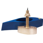 Clearances, Garmin, Garmin Sonar & Transducers, Lowrance, Lowrance Sonar & Transducers, Sanctuary Cove
AIRMAR B275LHW – Wide-beam Chirp-ready Thru-hull Transducer For Garmin
AIRMAR B275LHW – Wide-beam Chirp-ready Thru-hull
Get more coverage under your boat with Airmar’s unique wide-beam, low and high-frequency, Chirp-ready B275LHW. The high band operates across a frequency range of 150 to 250 kHz and has a fixed 25° beam for all frequencies which results in superior resolution. The constantly wide beam provides twice the coverage and clear fish arches on the display compared to most high-frequency, narrow-beam transducers.
The high wide is the ideal choice for both inshore and pelagic fishing, where resolution and maximum coverage under the boat are essentially down to 152 m (500′). The low-frequency band and 1 kW of power also support great deep-water performance. Get the best of both worlds with Airmar’s Chirp-ready transducers with wide-beam coverage.
The included High-performance Fairing improves broadband results at speeds over 30 knots (34 MPH).
SKU: 010-12183-20 -
Clearances, Garmin, Garmin Sonar & Transducers, Lowrance, Lowrance Sonar & Transducers
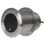
AIRMAR SS175HW – Wide-beam Chirp-ready Tilted Element™ Thru-hull Transducer – Fixed 12° tilted version for 8 to 15° hull deadrise angles
 Clearances, Garmin, Garmin Sonar & Transducers, Lowrance, Lowrance Sonar & Transducers
AIRMAR SS175HW – Wide-beam Chirp-ready Tilted Element™ Thru-hull Transducer – Fixed 12° tilted version for 8 to 15° hull deadrise angles
AIRMAR SS175HW – Wide-beam Chirp-ready Tilted Element™ Thru-hull Transducer – Fixed 12° tilted version for 8 to 15° hull deadrise angles
Get more coverage under your boat with Airmar’s unique wide-beam, high-frequency, Chirp-ready SS175HW. The high band operates across a frequency range of 150 to 250 kHz and has a fixed 25° beam for all frequencies. The high-frequency band delivers superior shallow-water performance, bottom detail, and fish-target separation. The constantly wide beam provides twice the coverage for detecting fish in the upper-water column and clear fish arches on the display compared to most high-frequency, narrow-beam transducers. The high wide is the ideal choice for both inshore and pelagic fishing, where resolution and maximum coverage under the boat are essential down to 152 m (500′).
Tilted Element™ transducers have the element fixed at 12° angle within the housing. Because the transducer is installed almost flush to the hull, the tilt corrects for the hull deadrise. It orients the ceramic element horizontally to ensure maximum echo returns to the transducer.
Features:
- Depth and fast-response water-temperature sensing
- 1 kW of power
- High frequency: 150 to 250 kHz
- Constant 25° beamwidth
- Maximum depth of 152 m (500’)
- 100 kHz of total bandwidth from one transducer
- Covers popular fishing frequency of 200 kHz plus everything else in the bandwidth
- Low-profile, thru-hull housing provides good display resolution at speed when installed properly
- Recommended for stepped, planing, or displacement hull
- Stainless steel housing for use in all hull materials
- Also available in a bronze housing (B175HW) and as thru-hull with fairing (B285HW), transom (TM185HW), and in-hull (M285HW) mounts
- Patented Xducer ID® technology
View Brochure
View Installation Instructions
Transducer University – Understanding Transducer Types
SKU: 000-13780-001, 000-13781-001, 000-13782-001 -
Clearances, Electrical, Switches
BEP Battery Distribution Cluster with DVSR – Twin Outboard Three Battery Banks
-8%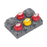 Clearances, Electrical, Switches
BEP Battery Distribution Cluster with DVSR – Twin Outboard Three Battery Banks
BEP Battery Distribution Cluster with DVSR – Twin Outboard Three Battery Banks
This system is designed to provide automatic battery management for twin outboard installations using outboards without AUX outputs. It is a preassembled module with solid links and application labels. Provides independent isolation of port start, starboard start and house batteries with the ability to emergency parallel both starting batteries, combined with a 140 amp DVSR connected to each engine. It will control the port engine to charge the port start battery first and then the house battery when the port start battery is fully charged. It will also control the starboard engine to charge the starboard start battery first and then charge the house battery when the starboard start battery is fully charged, giving a combined charge from both engines to the house battery until the voltage regulators of both engines control the charge. It will also allow the house battery to be charged if running on one engine.
SKU: BLA-113688 -
Batteries, Clearances, Electrical
BLA 12V 100Ah Lithium Marine Performance Batteries – Bluetooth Slimline Front Terminal
-20%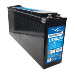 Batteries, Clearances, Electrical
BLA 12V 100Ah Lithium Marine Performance Batteries – Bluetooth Slimline Front Terminal
BLA 12V 100Ah Lithium Marine Performance Batteries – Bluetooth Slimline Front Terminal
The BLA Marine Performance Lithium is an exceptional range of batteries comprising of the highest quality Lithium Iron Phosphate composition. Lithium Iron Phosphate has been selected for the BLA range based on its favorable cell voltage, high energy density, cycle life and most importantly due to it being one of the safest Lithium technologies available.
The BLA Marine Performance Lithium range comes with all the advantages you assume will come from using Lithium Iron Phosphate while being skillfully designed into standard 12V Sealed Lead Acid (SLA) case sizes for convenient replacement. Up to 8 times the cycle life of standard SLA technology – BLA Marine Performance Lithium will lower your total cost of ownership and provide you with the latest in battery technology。
Features
- IEC Certification on the combination of BMS and individual cell for complete safety peace of mind
- High energy density (less than half the weight of SLA) lowering total weight of application
- Fast recharge, battery is charged and ready to be used sooner
- Flat discharge curve, longer run time and more efficient use of capacity
- Extremely low self-discharge rate, can sit unused for longer periods of time
- Large numbers of cycles >2000 (100% DoD), up to 8 times cycle life of SLA lowering your total cost of ownership
- Safe and stable chemistry and integrated BMS, the use of LiFePO4 along with integrated BMS ensures protection against over charge/discharge, temperature and short circuit providing the highest degree of safety.
- Bluetooth versions available, monitor the health and state of your battery from your phone
- Greater capacity utilization 60% more than SLA, gives longer runtime than equivalent SLA
High Cyclic applications
- 4×4 Vehicles
- Recreational Vehicles
- Caravan / Camping
Fast Charge requirement
- Medical Devices
- RC Devices
- Boats / Recreation
Low Weight applications
- Boats
- Golf Carts
- Personal power – Lighting, cameras etc
BLA Tradeshow 2023- MARINE PERFORMANCE BATTERIES
SKU: BLA-111185 -
Audio, Clearances, Fusion Marine, Fusion Stereo Units, Sanctuary Cove
Fusion® Apollo™ SRX400 – Apollo Marine Zone Stereo with Built-In Wi-Fi
-46%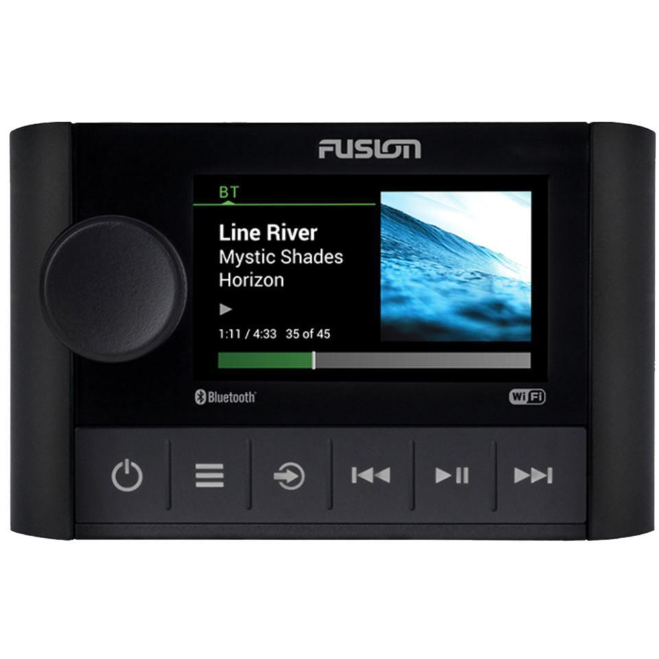 Audio, Clearances, Fusion Marine, Fusion Stereo Units, Sanctuary Cove
Fusion® Apollo™ SRX400 – Apollo Marine Zone Stereo with Built-In Wi-Fi
Fusion® Apollo™ SRX400 – Apollo Marine Zone Stereo with Built-In Wi-Fi – THE APOLLO RA770 STEREO’S PERFECT COMPANION
A perfect companion to Apollo RA770, the Fusion® Apollo™ SRX400 zone stereo combines premium design and superior sound in a compact form factor.

Custom audio profiles for each zone on your boat to deliver superior quality audio.

Audio streaming with Wi-Fi technology provides high-quality audio with a faster data transfer rate.

Experience seamless high-quality audio streaming from your music app via the AirPlay® 2 software feature.

Enjoy the freedom of musical choice with Fusion PartyBus™-Network technology.

Control your music from a compatible multifunction display (MFD), smart device or Garmin watch.
SKU: 010-01983-00 -
Clearances, Garmin, Garmin Sonar & Transducers, Sanctuary Cove
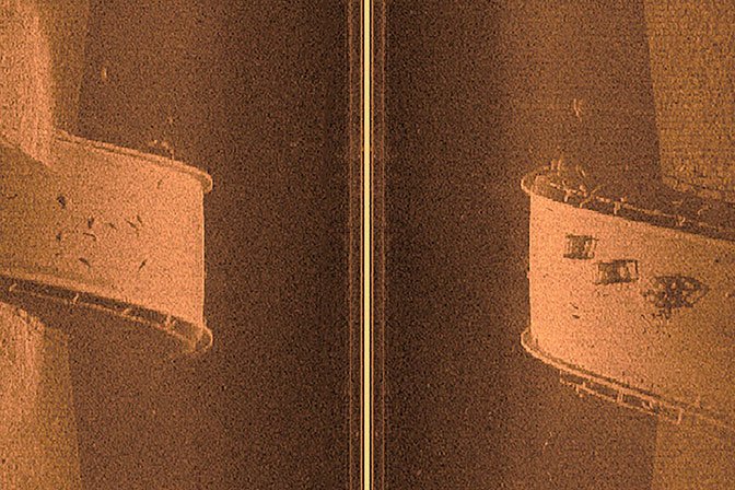
Garmin GCV™ 20 Scanning Sonar Black Box with GT34UHD-TM
-10% Clearances, Garmin, Garmin Sonar & Transducers, Sanctuary Cove
Garmin GCV™ 20 Scanning Sonar Black Box with GT34UHD-TM
Garmin GCV™ 20 Scanning Sonar Black Box with GT34UHD-TM – Redefine Scanning Sonar

See the stunning difference in clarity between standard scanning sonar on the left and Ultra High-Definition ClearVü scanning sonar on the right.
- Ultra High-Definition scanning sonar system provides crisp images of structure and fish in stunning detail
- Ultra High-Definition ClearVü sonar provides brilliant image clarity of structure and fish up to 200’ deep below your boat
- Ultra High-Definition SideVü sonar delivers stunningly clear images of structure and fish off to the sides of your boat
- System includes easy-to-install, networkable GCV™ 20 sonar black box with three-array transducer; includes transom and trolling motor mounts
- Share seamlessly across multiple networked chartplotters as well as networking Panoptix™ all-seeing sonar
Clarity and detail are redefined with the Ultra High-Definition scanning sonar system. Using an easy-to-install, networkable GCV 20 sonar black box with an included three-array GT34UHD transducer, now you can get scanning sonar images in ultra high-definition. You see everything below and off to the sides of your boat in amazingly sharp, crisp detail.
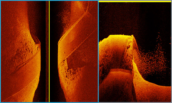
Ultra High-Definition ClearVü Scanning
This sonar system provides brilliant image clarity of structure and fish below your boat at greater depths than other high-frequency scanning sonars by putting more power on targets via a downward-facing element.


Ultra High-Definition SideVü Scanning
See stunningly clear images of structure and fish off to the sides of your boat. This makes it easy to scout a fishing area quickly, because you can see everything the first time with such amazing clarity.

Share Sonar Images
You can share your Ultra High-Definition scanning sonar images seamlessly across multiple networked chartplotters. You can also add optional Panoptix all-seeing sonar to your networked sonars.
What’s in the box
- GCV 20 Sonar Black Box
- GT34UHD-TM transducer
- Transom mount
- Trolling motor mount
- Right-angle power cable
- Right-angle ethernet cable
- Mounting hardware
- Documentation
View Installation Instructions
Garmin Ultra High-Definition Scanning Sonar System
SKU: 010-02055-00 -
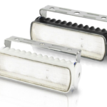
Clearances, Deck/Interior, Lighting
Hella Marine Sea Hawk-R LED Floodlights
Hella Marine launches new Hella Marine Sea Hawk-R LED Floodlights.
Future technology has been applied to the successful Sea Hawk series for class-leading efficiency and guaranteed durability.
SKU: 2LT 980 573-011, 2LT 980 573-021, 2LT 980 573-051, 2LT 980 573-061 -
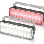
Clearances, Deck/Interior, Lighting
Hella Marine Sea Hawk-XL Dual Colour LED Floodlights
Hella Marine Sea Hawk-XL Dual Colour LED Floodlights – Professional sports fishermen, commercial operators, and ocean racers all recognise the ‘non-glare’ night vision preservation advantages of red lighting.
SKU: 2LT 980 950-041, 2LT 980 950-051, 2LT 980 950-061, 2LT 980 950-071, 2LT 980 950-081, 2LT 980 950-091 -
Clearances, Humminbird, Humminbird Fish Finders
Humminbird SOLIX 12 CHIRP MEGA SI+ G3 INC NAV CARD
-11%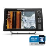 Clearances, Humminbird, Humminbird Fish Finders
Humminbird SOLIX 12 CHIRP MEGA SI+ G3 INC NAV CARD
Humminbird SOLIX 12 CHIRP MEGA SI+ G3 INC NAV CARD
The SOLIX 12 CHIRP MSI+ G3 combines cutting-edge technologies like MEGA Side Imaging+, MEGA Down Imaging+, Dual Spectrum CHIRP Sonar and AutoChart Live on an ultra-clear Cross Touch® display. Take full advantage of the generous 12.1″ touchscreen display with customizable views and settings that allow you to see multiple technologies at once and find what you want quickly via the convenient side bar menu. Leverage the networking power of built-in Wi-Fi and NMEA 2000®, as well as Bluetooth® and Ethernet connections for compatibility with the One-Boat Network™ family of products from Humminbird, Minn Kota and Cannon. This unit includes a Navionics+ map card.
FEATURES- Cross Touch® Interface: Control your fish finder using the touchscreen or the keypad—it’s up to you. Any menu navigation you can do on the touchscreen can also be done on the keypad, providing quick and intuitive access to technologies on your terms, no matter your situation and conditions.
- Customised Experience: Utilise an intuitive user interface and sidebar menu which provide customisable settings and view combinations to make your fishing experience all your own.
- NEW Dual Core Processor: Perform any task with speed and ease, thanks to the ultra-responsive interface and upgraded processing power.
- Airmar® Transducer ID: For those looking to install accessory 2D Airmar transducers, SOLIX G3 provides transducer ID to make for fast and simple setup.
- Industry-leading Humminbird sonar: Equipped with MEGA Side Imaging+, MEGA Down Imaging+ and Dual Spectrum CHIRP sonar to keep you on the fish. MEGA Imaging+ provides views up to 250′ under and out to either side of your boat and Dual Spectrum CHIRP shows exceptional 2D sonar with superior target separation and fish clarity.
- Internal GPS and Humminbird Basemap: Our enhanced basemap provides you with a clear view of underwater terrain and surrounding points of interest so you can fish and navigate with total confidence. Identify buoys, day markers, hazards, marinas, contours, depth markers and much, much more.
- AutoChart Live: Create real-time maps of your fishing spots. Map depth contours, bottom hardness and vegetation as you drive your boat. Comes standard with eight (8) hours of built-in recording time and is compatible with AutoChart Zero Line SD cards for virtually-endless AutoChart Live mapping capacity.
- One-Boat Network Compatible: Many Humminbird models seamlessly integrate and communicate with Minn Kota and Cannon products to unlock more features and capabilities for anglers everywhere. Make the more of your time on the water with the exclusive boat control and fish-catching features of the One-Boat Network.
- Ethernet Networking: High-speed Ethernet allows you to build a powerful, professional-grade fishing system. Easily connect multiple fish finders, or upgrade to add-on technologies like Minn Kota i-Pilot Link and Humminbird CHIRP Radar.
- Bluetooth: Take control right from the screen of your Humminbird with wireless communication to compatible Talon and Raptor shallow water anchors, as well as Cannon Optimum downriggers. Additional features include wireless software updates from the Humminbird FishSmart App and display of smart phone notifications on your Humminbird.
- NMEA 2000 networking built-in: Connect an accessory NMEA 2000 network to your control head for even more information; from boat performance to weather and water conditions, make sense of it all with NMEA 2000 networking.
- Compatible with CZone® Contact 6, Contact 6 Plus and digital switching devices
- Includes control head, transom mount transducer, mounting hardware, power cable, and gimbal mounting bracket. Product comes with 2-Year Limited Warranty.
SOLIX Installation Instructions
Transducer Installation Instructions
Operations Manual
How to Install a Humminbird SOLIX In-Dash Kit on a Skiff
SKU: 104636AU -
-
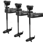
Clearances, Lowrance, Lowrance Trolling Motors
Lowrance Ghost Trolling Motor
Reliable, rugged and built to last, the new ultra-quiet Lowrance® Ghost™ trolling motor lets anglers fish longer, run faster and move in closer without spooking fish. Ghost has a revolutionary brushless motor with the most thrust and the longest run time of any trolling motor on the market. With integrated Lowrance sonar options, waypoint anchoring and a three-year warranty, Ghost is the new standard for your trolling motor upgrade.
SKU: 000-14937-001, 000-14938-001, 000-15480-001 -
12V Accessories, Clearances, Electrical
Relaxn Power Outlet and Dual USB Charger Combo – Flush Mount
-37%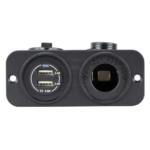 12V Accessories, Clearances, Electrical
Relaxn Power Outlet and Dual USB Charger Combo – Flush Mount
Relaxn Power Outlet and Dual USB Charger Combo – Flush Mount
• Panel mount.
• Flame retardant nylon glass fibre reinforced and UV stabilised enclosure.
• Supplied with water resistant rubber cap (IP66).
• LED power indication.
• Short circuit and overheating protection.
• 6.4mm quick connect terminals.
• Mount with 8 gauge stainless steel screws included.Power Outlet Features:
• DC power outlet.
• Rating 12V at 20A.Dual USB Charger Features:
• Input 12V/24V.
• Compatible with all smartphones and GoPro.
• Optimised for the latest iPhone / iPad models for fast charging at full speed (2.4Amps for iPad, 1.5~2Amps for iPhone/iPod).PART NUMBER PACK SIZE HOUSING COLOUR IP RATING MAX CURRENT USB CHARGER OUTPUT L X W X H SAW-530002 1 Black IP66 12V – 20 Amps 5V 4.8A 110mm x 80mm x 48.8mm SAW-530002-10 10 Black IP66 12V – 20 Amps 5V 4.8A – SAW-530003 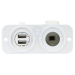
1 White IP66 12V – 20 Amps 5V 4.8A 110mm x 80mm x 48.8mm SAW-530003-10 10 White IP66 12V – 20 Amps 5V 4.8A – SKU: SAW-530002, SAW-530002-10, SAW-530003, SAW-530003-10 -
12V Accessories, Clearances, Electrical
Relaxn Surface Mount Power Outlet Single Socket
Relaxn Surface Mount Power Outlet Single Socket
USB Charger Features:
• Optimised for iPad, iPhone and iPod – fast charging at full speed (2.1Amps
for iPad, 1Amp for iPhone/iPod).
• Compatible with other smartphones.
• Input: 12V. Output: 5V-2.1Amp.
• Short circuit / overheat protection.
• 0.250 inch quick connect terminals.
• LED power indication.
• Supplied with water resistant and dust proof rubber cap.
• Flame retardant nylon (glass fibre reinforced) enclosure.Power Outlet Features:
• DC power outlet.
• Flame retardant nylon (glass fibre reinforced) enclosure.
• 0.250 inch quick connect terminals.
• Rating: 12V at 20A.PART NUMBER COLOUR HEIGHT LENGTH WIDTH SAW-53039 
White 48mm 80mm 56mm SAW-53039-10 White 48mm 80mm 56mm SAW-53040 
Black 48mm 80mm 56mm SAW-53040-10 Black 48mm 80mm 56mm SKU: SAW-53039, SAW-53039-10, SAW-53040, SAW-53040-10 -
Clearances, Lowrance, Lowrance Sonar & Transducers
XSONIC AIRMAR PM275LHW – Wide-beam Chirp-ready Pocket Mount Transducer
-41% Clearances, Lowrance, Lowrance Sonar & Transducers
XSONIC AIRMAR PM275LHW – Wide-beam Chirp-ready Pocket Mount Transducer
AIRMAR PM275LHW – Wide-beam Chirp-ready Pocket Mount
Get more coverage under your boat with Airmar’s unique wide-beam, low and high-frequency, Chirp-ready PM275LHW. The high band operates across a frequency range of 150 to 250 kHz and has a fixed 25° beam for all frequencies which results in superior resolution. The constantly wide beam provides twice the coverage and clear fish arches on the display compared to most high-frequency, narrow-beam transducers.
The high wide is the ideal choice for both inshore and pelagic fishing, where resolution and maximum coverage under the boat are essentially down to 152 m (500′). The low-frequency band and 1 kW of power also support great deep-water performance. Get the best of both worlds with Airmar’s Chirp-ready transducer with wide-beam coverage.
SKU: 000-13940-001