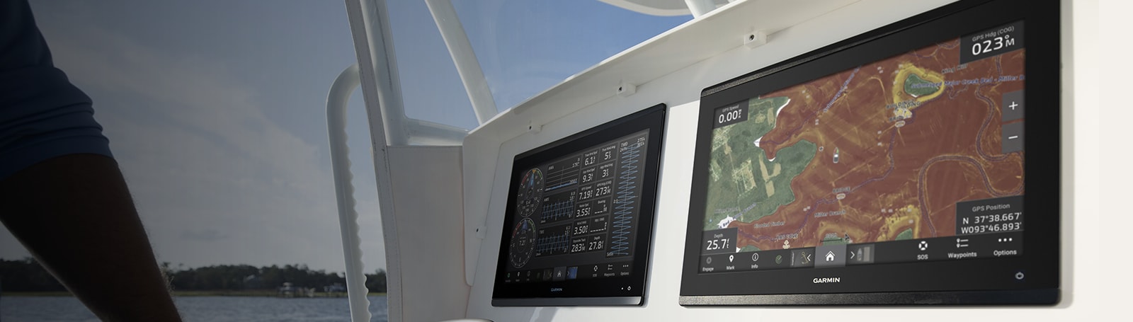
Marine Electronics
Showing 1–30 of 79 results
-
EOFY, Garmin, Garmin VHF and AIS, Marine Electronics, Sanctuary Cove, VHF & AIS
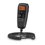
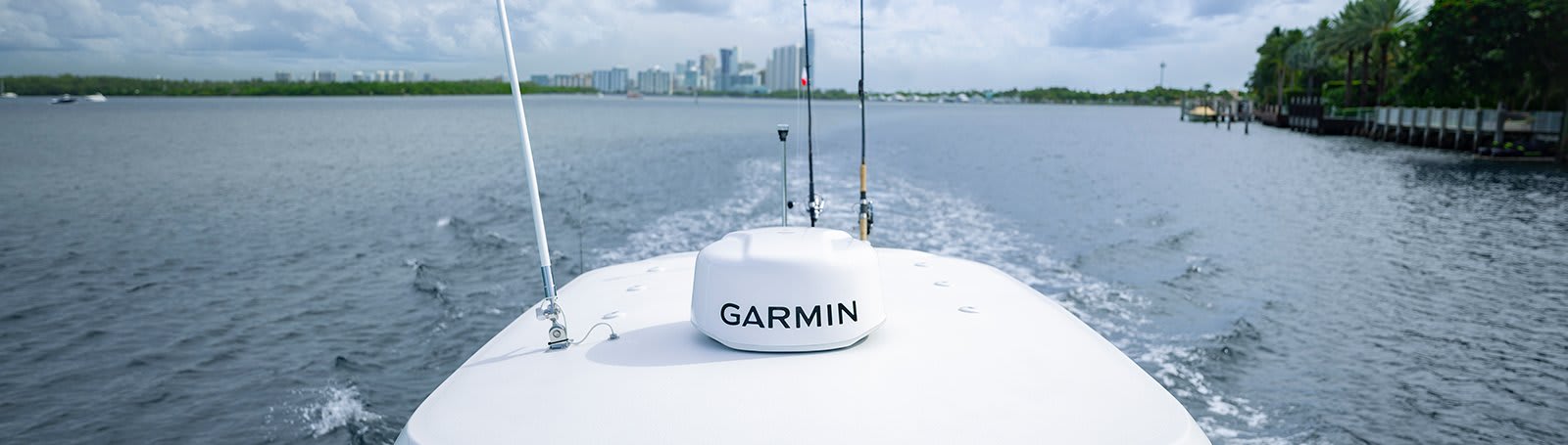
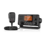
Garmin 115i VHF Marine Radio with DSC
-9%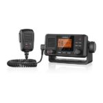 EOFY, Garmin, Garmin VHF and AIS, Marine Electronics, Sanctuary Cove, VHF & AIS
Garmin 115i VHF Marine Radio with DSC
Garmin 115i VHF Marine Radio with DSC
Stay in Contact on the Water
- Fixed-mount radio with plug and play via the NMEA 2000® network
- Standard Class D Digital Selective Calling (DSC) functionality (distress calling and direct calling with user-programmed MMSI)
- In case of trouble, DSC may improve your chances of a rapid rescue
- 25-watt transmit power with built-in GPS
- Frequency bands include all U.S., Canadian and international marine channels plus 10 NOAA weather channels
Communication is critical on the water. With the VHF 115i radio, you can stay in contact with the shore and other boats in your area. So, no matter where you are or where you’re headed, you’ll maintain communication.
Increase Your Peace of Mind
During an emergency situation, the 25-watt transmit power of VHF 115i gives fishermen, sailors and cruisers confidence at their fingertips.Communicate Confidently on the Water
Easy to install and use, just plug and play to compatible Garmin chartplotters and MFDs via the NMEA 2000 network. VHF 115i provides standard Class D DSC functionality (distress calling and direct calling with user-programmed MMSI). The radio includes frequency bands for all U.S., Canadian and international marine channels and 10 NOAA weather channels. It’s also NMEA 0183 compatible.Communicate with Style
Because your helm is a source of pride, we’ve designed the VHF 115i marine radio to complement GPSMAP® 7×2/9×2, GPMAP 10×2/12×2, GPSMAP 7400/7600 and GPSMAP 8400/8600 chartplotters and MFDs.What’s in the box?
- VHF 115i marine radio
- Bail mount with knobs and mounting hardware
- Protective cover
- Trim ring snap cover
- Flush mount gasket
- Power cable
- Documentation
Installation Instructions
Owner’s Manual
SKU: 010-02096-01 -
Garmin, Garmin VHF and AIS, Marine Electronics, Sanctuary Cove, VHF & AIS
Garmin AIS™ 800 Blackbox Transceiver
-3%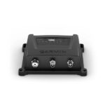 Garmin, Garmin VHF and AIS, Marine Electronics, Sanctuary Cove, VHF & AIS
Garmin AIS™ 800 Blackbox Transceiver
Garmin AIS™ 800 Blackbox Transceiver – Help Avoid Running into Trouble on the Water
- Easy-to-use, reliable communication transmits your vessel information to other AIS receivers in your area while receiving AIS target data
- 5 watts of transmit power with Class B/SO provides faster positioning reporting than ever before¹
- Built-in GPS with connector for optional external antenna
- NMEA 2000® connectivity for easy integration with compatible chartplotters and multifunction displays
- Internal VHF antenna splitter allows VHF and AIS to share a single antenna
Increase your situational awareness and confidence on the water with the Garmin AIS 800 transceiver. It has 5 watts of transmit power and provides faster position reporting than ever before¹. It transmits your vessel information to other AIS receivers in your area while it receives their AIS target data. Garmin AIS 800 has an internal VHF antenna splitter, which allows the VHF and AIS to share a single antenna. It includes a built-in GPS (with connector for optional external antenna) and integrates seamlessly into the Garmin onboard system. The transceiver features NMEA 2000/0183 connectivity for easy integration with compatible chartplotters and multifunction displays. And it’s all packed into an easy-to-install black box unit with a small footprint.
¹When cruising above 14 knots
Specs
- Dimensions: 17.5 x 14.2 x 5.5 cm
- Weight: 0.9 lbs (414 g)
- Operating Temperature Range: 5°F to 131°F (-15°C to 55°C)
- Waterproof Rating: IPX7
- Compass safe distance: 15.8” (40 cm)
- Operating Voltage: 9.6 – 31.2 Vdc
- Current Drain: 12Vdc: < 400 mA; 24Vdc: <250 mA
- Antenna Connector: S0-239 (50 Ω)
- GPS refresh rate: 1 Hz
- Max Antenna Gain: 9 dB
- Transmitter Power: 5 W
- NMEA 2000 LEN: 2
- NMEA 0183: Yes
In the Box
- AIS 800
- NMEA 2000® T-connector
- NMEA 2000 drop cable (2 meters)
- VHF antenna extension (1.2 meters)
- USB adapter cable
- Power cable
- Mounting hardware
- Documentation
SKU: 010-02087-00 -
Garmin, Garmin Accessories, Marine Electronics
Garmin BlueChart g3 Vision – East Coast of Australia
-8%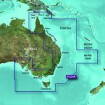 Garmin, Garmin Accessories, Marine Electronics
Garmin BlueChart g3 Vision – East Coast of Australia
### GARMIN SALE – ONLINE ONLY DEAL – WHILE STOCKS LAST – MUST END###
Garmin BlueChart g2 Vision – East Coast of Australia [Garmin Part Number: 010-C0756-00] – RRP $399
Get a fresh perspective when you take to the water with BlueChart® g2 Vision®. With BlueChart g2 Vision data, you’ll get detailed marine cartography that provides convenient viewing of nautical content and other premium features. BlueChart g2 Vision allows you to see your vessel’s precise, on-chart position in relation to naviads, coastal features, anchorages, obstructions, waterways, restricted areas and more. You will also have access to detailed mapping capabilities that include Safety Shading, Fishing Charts, smooth data transition between zoom levels, harmonious transition across chart borders, and reduction of chart discontinuities. Premium features include 3-D perspective above and below the waterline, Auto Guidance, high-resolution imagery, and “real picture” aerial photos of ports, harbours, marinas, waterways, landmarks and other points of interest. It’s the most realistic mapping display Garmin has ever offered.
Detailed coverage of the Eastern coast of Australia from Mornington Island to Fowlers Bay (VPC022R). Also includes detailed coverage of Cape York, the Great Barrier Reef, Brisbane, Sydney, Melbourne, Adelaide, Tasmania, and Norfolk Island (if another region is required please contact us for availability).
THIS IS SUITABLE FOR CURRENT MODEL GARMIN GPSMAP 7407xsv, GPSMAP 7408xsv, GPSMAP 7410xsv, GPSMAP 7412xsv, echoMAP 75dv, echoMAP 75sv & echoMAP 95sv SOUNDER/GPS COMBO UNITS, PLEASE SEE RELATED PRODUCTS OR ASK FOR FURTHER INFORMATION.
WARRANTY:
We are an authorised Australian Garmin retailer, as such Full Australian Manufacturers Warranty is applicable for this item. Please note if a Garmin unit is purchased overseas or from a non-authorised Garmin retailer you may not receive warranty coverage in Australia.*Specifications from suppliers’ information. Actual depth capabilities depend on transducer installation, bottom type & water conditions. All sonars typically read deeper in freshwater than in saltwater. Images for display purposes only.
SKU: 010-C0756-00 -
Garmin, Garmin Radars, Marine Electronics, Radars, Sanctuary Cove
Garmin Dome Radar GMR 18 xHD3 – 4kW 18”
-6% Garmin, Garmin Radars, Marine Electronics, Radars, Sanctuary Cove
Garmin Dome Radar GMR 18 xHD3 – 4kW 18”
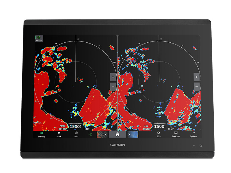
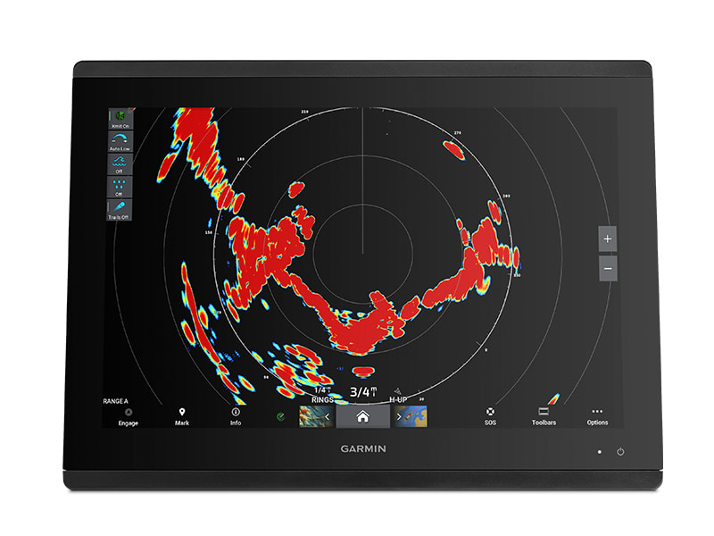
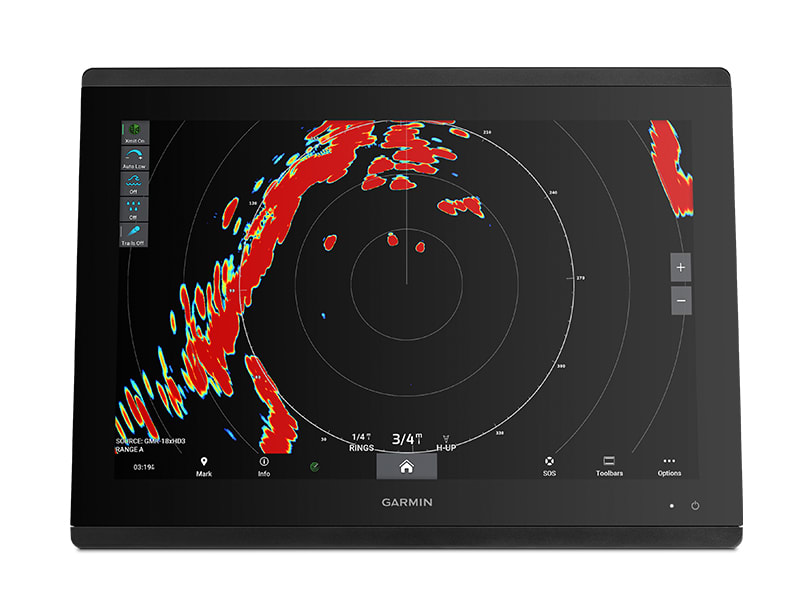
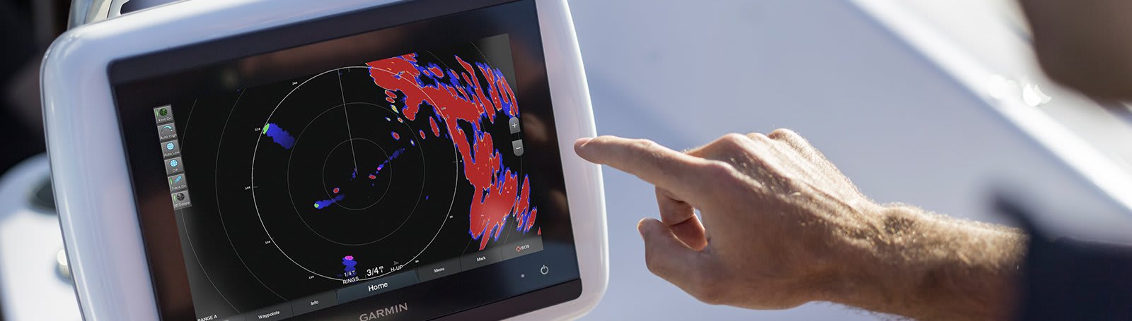
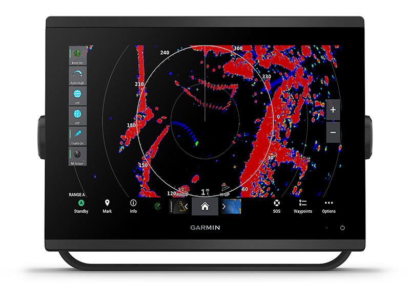
Garmin Dome Radar GMR 18 xHD3 – 4kW 18” – GET ROBUST MAGNETRON SCANNING IN A COMPACT GARMIN DOME RADAR
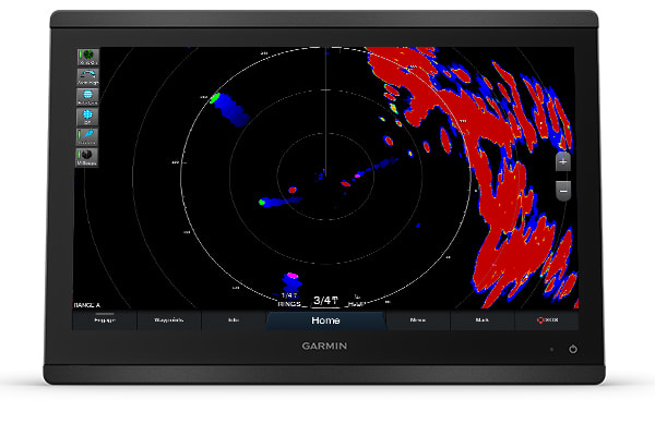
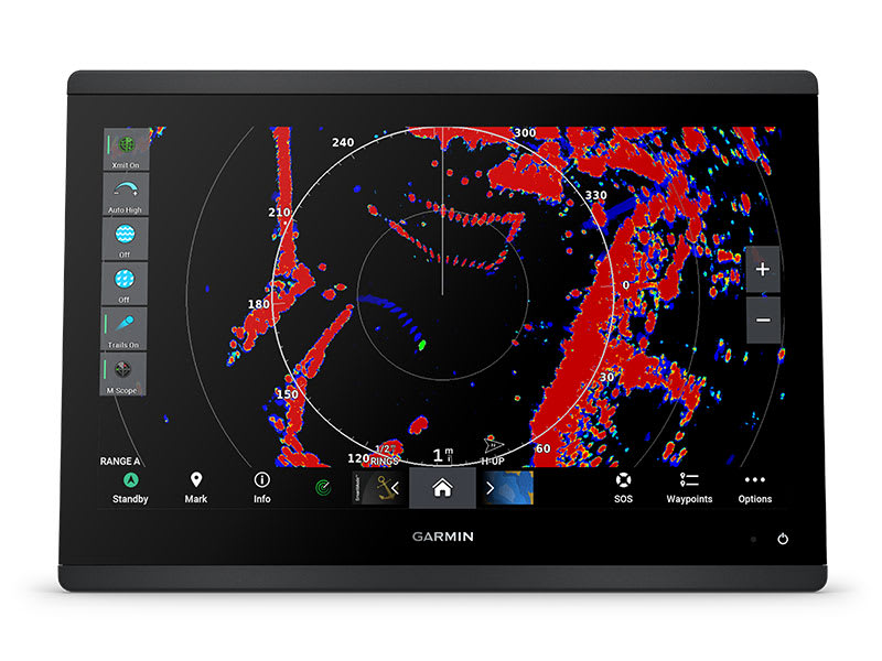
Loaded with advanced features typically found on open arrays, these powerful 18″ and 24″ dome radars offer superior traffic, obstacle and weather detection for peace of mind on the water.
 4kW POWER OUTPUT, 48-NAUTICAL MILE MAX RANGE
 SCAN AVERAGING TECHNOLOGY
 IMPROVED TARGET-SIZE PROCESSING
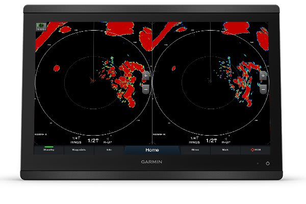
 SPLIT-SCREEN DUAL-RANGE DISPLAY
 BIRD DETECTION
 QUIET DOME DRIVE MOTOR
TOP FEATURES
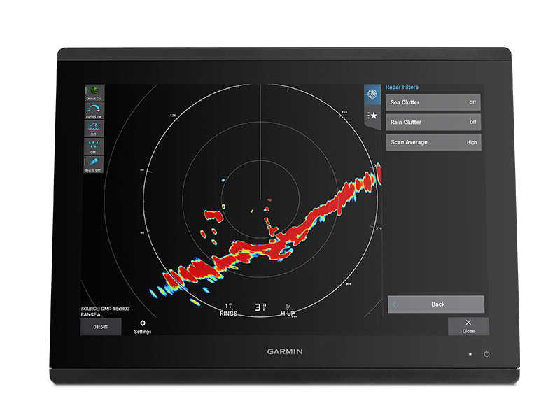
NEW SCAN AVERAGING TECHNOLOGY
A first for Garmin magnetron radar, scan averaging helps filter out sea clutter and interference to enhance the detection and display of consistent targets.
ANGULAR TARGET-SIZE ADJUSTMENT
Pulse expansion and angular target-size processing techniques optimise on-screen object shapes for better interpretation at all range scales.
FASTER SCANNING ANTENNA
Rotation speeds up to 60 rpm improve the redraw rate for faster target updates.
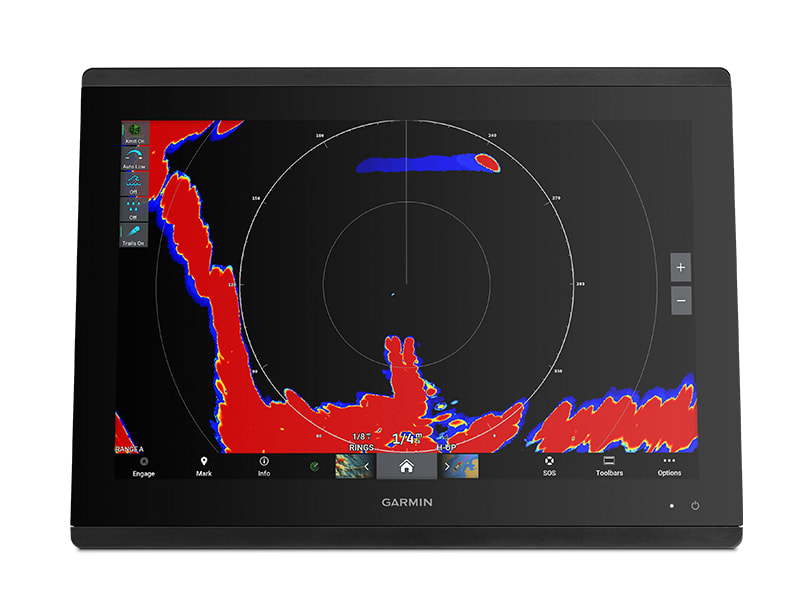
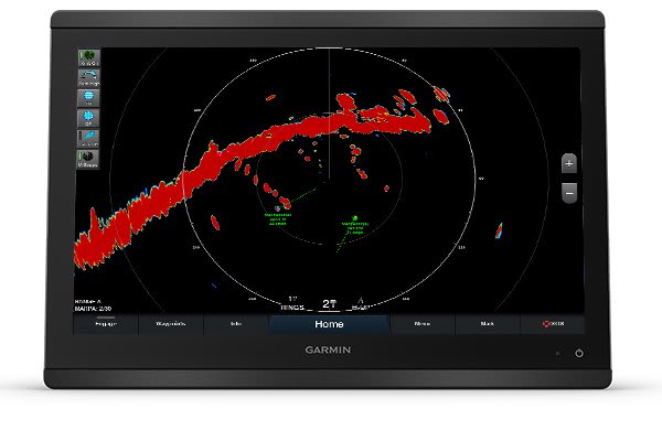
TRUE ECHO TRAILS
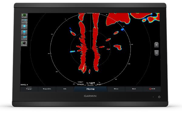
A historical “trail” of boats on the water is displayed on the screen, removing relative motion influence to help you quickly identify moving targets and potential collision threats.
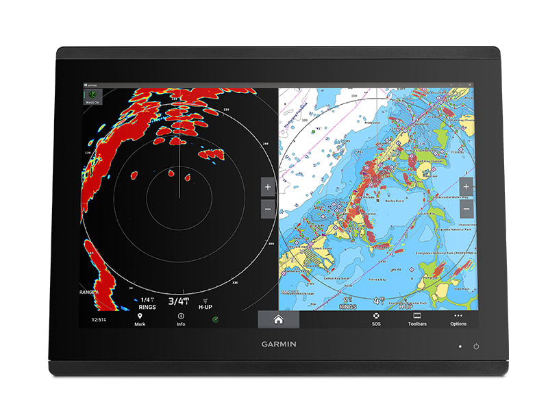
DUAL RANGE WITH OVERLAY
A single radar antenna is capable of providing split-screen, side-by-side images on your compatible chartplotter, with independent range setting and controls for both close and long range. Overlay either or both ranges on a chart.
DYNAMIC AUTO GAIN
Gain automatically adjusts levels to optimum settings for harbours, near shore and offshore in open waters.
SEE MORE OF WHAT’S OUT THERE
 RADAR OVERLAY: See overlaid images on your chartplotter’s map screen (with appropriate sensors, sold separately).
 HIGH-RESOLUTION RADAR: Pick out targets at a distance, thanks to narrow horizontal beamwidth and high antenna gain. DUAL-RADAR SUPPORT: This provides redundancy and allows each display unit to pull data from different sources.
 DYNAMIC SEA FILTER: Radar gain automatically adjusts sea clutter for calm, medium and rough sea conditions. AUTO BIRD GAIN: Locate flocks of birds at the water’s surface where baitfish are also likely to be found.
 MARPA TARGET TRACKING: Track up to 30 targets to help avoid collisions (with appropriate sensors, sold separately).
 GUARD ZONE: Set the safety zone, and receive an alarm when an object enters the zone.
 RANGE AND BEARING CUES: Variable range markers and electronic bearing lines allow rapid measurements of distance and bearing to vessels and land.
In the box
- GMR 18 or 24 dome radar (depending on model selected)
- Power cable (15 m/49.21 ft)
- Network cable (15 m/49.21 ft)
- Mounting hardware kit and template
- Installation instructions
Installation Instructions
Garmin GMR xHD3
SKU: 010-02841-00 -
Garmin, Garmin Radars, Marine Electronics, Radars, Sanctuary Cove
Garmin Dome Radar GMR 24 xHD3 – 4kW 24”
-6%Garmin, Garmin Radars, Marine Electronics, Radars, Sanctuary CoveGarmin Dome Radar GMR 24 xHD3 – 4kW 24”
Garmin Dome Radar GMR 24 xHD3 – 4kW 24” – GET ROBUST MAGNETRON SCANNING IN A COMPACT GARMIN DOME RADAR
Loaded with advanced features typically found on open arrays, these powerful 24″ dome radars offer superior traffic, obstacle and weather detection for peace of mind on the water.
4kW POWER OUTPUT, 48-NAUTICAL MILE MAX RANGE SCAN AVERAGING TECHNOLOGY IMPROVED TARGET-SIZE PROCESSING SPLIT-SCREEN DUAL-RANGE DISPLAY BIRD DETECTION QUIET DOME DRIVE MOTORTOP FEATURES
NEW SCAN AVERAGING TECHNOLOGY
A first for Garmin magnetron radar, scan averaging helps filter out sea clutter and interference to enhance the detection and display of consistent targets.
ANGULAR TARGET-SIZE ADJUSTMENT
Pulse expansion and angular target-size processing techniques optimise on-screen object shapes for better interpretation at all range scales.
FASTER SCANNING ANTENNA
Rotation speeds up to 60 rpm improve the redraw rate for faster target updates.
TRUE ECHO TRAILS
A historical “trail” of boats on the water is displayed on the screen, removing relative motion influence to help you quickly identify moving targets and potential collision threats.
DUAL RANGE WITH OVERLAY
A single radar antenna is capable of providing split-screen, side-by-side images on your compatible chartplotter, with independent range setting and controls for both close and long range. Overlay either or both ranges on a chart.
DYNAMIC AUTO GAIN
Gain automatically adjusts levels to optimum settings for harbours, near shore and offshore in open waters.
SEE MORE OF WHAT’S OUT THERE
RADAR OVERLAY: See overlaid images on your chartplotter’s map screen (with appropriate sensors, sold separately). HIGH-RESOLUTION RADAR: Pick out targets at a distance, thanks to narrow horizontal beamwidth and high antenna gain. DUAL-RADAR SUPPORT: This provides redundancy and allows each display unit to pull data from different sources. DYNAMIC SEA FILTER: Radar gain automatically adjusts sea clutter for calm, medium and rough sea conditions. AUTO BIRD GAIN: Locate flocks of birds at the water’s surface where baitfish are also likely to be found. MARPA TARGET TRACKING: Track up to 30 targets to help avoid collisions (with appropriate sensors, sold separately). GUARD ZONE: Set the safety zone, and receive an alarm when an object enters the zone. RANGE AND BEARING CUES: Variable range markers and electronic bearing lines allow rapid measurements of distance and bearing to vessels and land.In the box
- GMR 24 dome radar (depending on model selected)
- Power cable (15 m/49.21 ft)
- Network cable (15 m/49.21 ft)
- Mounting hardware kit and template
- Installation instructions
Installation Instructions
Garmin GMR xHD3
SKU: 010-02842-00 -
Garmin, Garmin Radars, Marine Electronics, Sanctuary Cove
Garmin Dome Radar GMR Fantom 18x – 50W 18″ White
-6%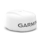 Garmin, Garmin Radars, Marine Electronics, Sanctuary Cove
Garmin Dome Radar GMR Fantom 18x – 50W 18″ White
Garmin Dome Radar GMR Fantom 18x – 50W 18″ White – STRIKINGLY POWERFUL RADAR
These incredibly powerful 18″ and 24″ dome radars have beauty and brains with a black colour option and 50 watts of output power.

GMR Fantom brings the power. Fifty watts of it, actually.

See targets clearly, and adjust their sizes as needed.

With power save mode, you get to choose when to use full power and when to pull back.

Every second of power usage counts. Cut back even more by choosing your active times down to the second.

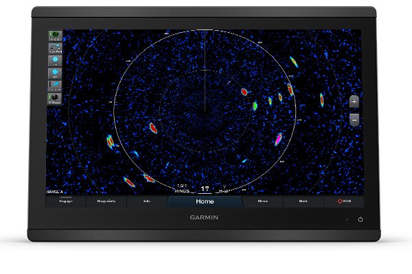
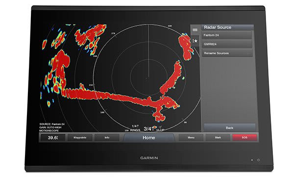
MotionScope™ technology shows targets in colour as they move toward you or away.
SKU: 010-02584-00 -
Garmin, Garmin Radars, Marine Electronics, Sanctuary Cove
Garmin Dome Radar GMR Fantom 18x – 50W 18″ Black
-8%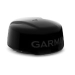 Garmin, Garmin Radars, Marine Electronics, Sanctuary Cove
Garmin Dome Radar GMR Fantom 18x – 50W 18″ Black
Garmin Dome Radar GMR Fantom 18x – STRIKINGLY POWERFUL RADAR
These incredibly powerful 18″ and 24″ dome radars have beauty and brains with a black colour option and 50 watts of output power.
GMR Fantom brings the power. Fifty watts of it, actually.
See targets clearly, and adjust their sizes as needed.
With power save mode, you get to choose when to use full power and when to pull back.
Every second of power usage counts. Cut back even more by choosing your active times down to the second.
MotionScope™ technology shows targets in colour as they move toward you or away.
SKU: 010-02584-10 -
Garmin, Garmin Radars, Marine Electronics, Sanctuary Cove
Garmin Dome Radar GMR Fantom 24x – 50W 24″ Black
-5%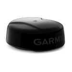 Garmin, Garmin Radars, Marine Electronics, Sanctuary Cove
Garmin Dome Radar GMR Fantom 24x – 50W 24″ Black
Garmin Dome Radar GMR Fantom 24x – 50W 24″ Black – STRIKINGLY POWERFUL RADAR
These incredibly powerful 18″ and 24″ dome radars have beauty and brains with a black colour option and 50 watts of output power.
GMR Fantom brings the power. Fifty watts of it, actually.
See targets clearly, and adjust their sizes as needed.
With power save mode, you get to choose when to use full power and when to pull back.
Every second of power usage counts. Cut back even more by choosing your active times down to the second.
MotionScope™ technology shows targets in colour as they move toward you or away.
See what’s coming.
HIGH-POWERED RADAR
These 50-watt solid-state dome radars have a range from 20’ to 48 nautical miles, even in fog or rain. Plus, they deliver up to 60 RPM rotation speed for a refresh rate that can detect movement at any speed. This time around, we even have a white and black option so you can tailor to your boat.
HIGH-RESOLUTION RADAR
High-resolution images and high antenna gain help to pick out targets at a distance, while 8-bit true colour imagery enhances target separation.
MOTIONSCOPE TECHNOLOGY
MotionScope uses the Doppler effect to detect moving targets and highlight them in different colours, so you can navigate around other boats or severe weather — or toward fishing spots where birds feed at the surface.
POWER SAVE MODE
The power save feature lets you choose when you need more power or less, so you have power when you need it and conserve it when you don’t.
TIMED TRANSMIT MODE
With timed transmit mode, you can even specify active and inactive times down to the second to help reduce power consumption, so you can stay on the water longer than ever.
INTUITIVE OPERATION
These radars don’t have any complex user settings to deal with, so they’re easy to install and start using.
See incredible detail on the water.
TARGET SIZE
Adjust on-screen target resolution for better separation based on your surroundings.
AUTO BIRD GAIN
Locate flocks of birds at the water’s surface where baitfish are also likely to be found.
ECHO TRAILS
See a historical ″trail″ on the screen to help you quickly and easily identify moving targets and potential collision threats.
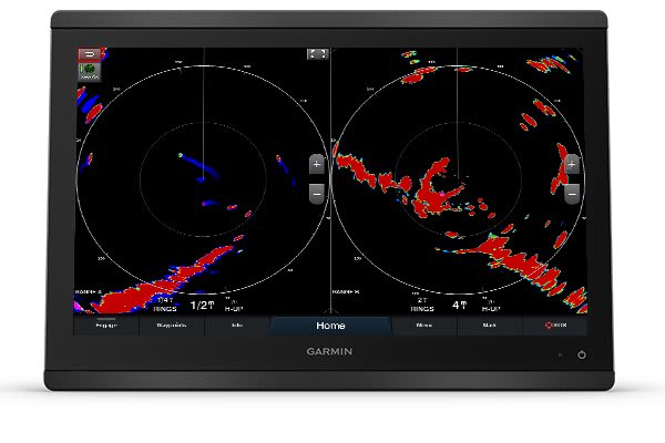
DUAL RANGE
The single radar antenna can provide split-screen images on your chartplotter side by side, with independent range setting and controls for both close and long range.
DUAL-RADAR SUPPORT
Using dual radar provides redundancy and allows each display unit on the boat to pull data from one of two different radar sources.
DYNAMIC AUTO GAIN
This feature automatically adjusts to your surroundings for optimal performance in all conditions.
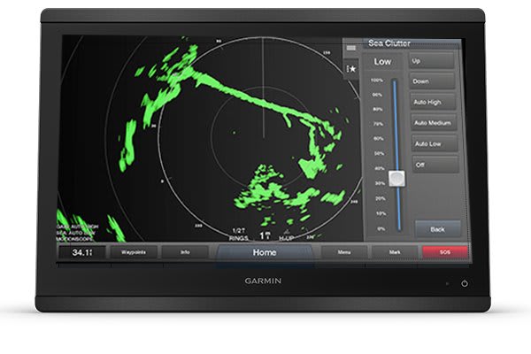
DYNAMIC SEA FILTER
Gain automatically adjusts sea clutter for calm, medium and rough sea conditions.
RADAR OVERLAY
Overlay radar images onto your chartplotter’s map page. You can add an optional autopilot or heading sensor (sold separately) for best results.
AUTOMATIC ACQUISITION
New mini-automatic radar plotting aid (MARPA) automatic acquisition allows for triggering and tracking of up to 30 targets with no user prompting on all returns, boundary zones, guard zones or MotionScope technology.
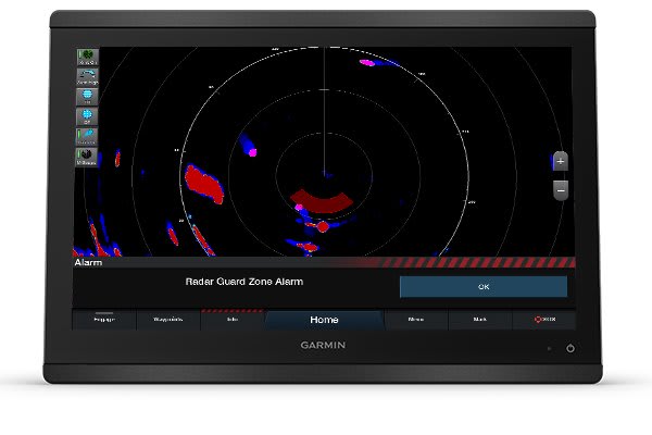
GUARD ZONE
Set the safety zone and receive an alarm when an object enters the zone.
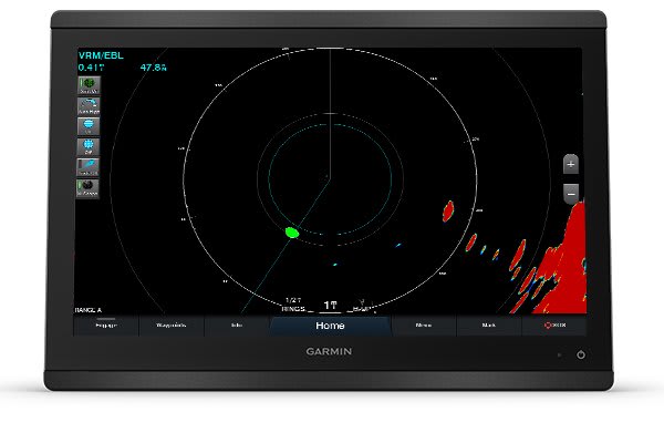
VRM AND EBL
Variable range markers (VRM) and electronic bearing lines (EBL) allow rapid measurements of distance and bearing to vessels and land.
In the box
- GMR Fantom 18x or 24x Dome Radar(depending on model selected)
- Power cable (15 m/49.21 ft)
- Network cable (15 m/49.21 ft)
- Network adapter cable (GMN 2.0 Small to GMN)
- Installation instructions
- Mounting hardware kit and template
- Garmin Marine Network adapter cable (small connector to large connector)
View Installation Instructions
Installation of the Garmin Fantom 18x Radar Dome
SKU: 010-02585-10 -
Garmin, Garmin Radars, Marine Electronics, Sanctuary Cove
Garmin Dome Radar GMR Fantom 24x – 50W 24″ White
-6%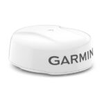 Garmin, Garmin Radars, Marine Electronics, Sanctuary Cove
Garmin Dome Radar GMR Fantom 24x – 50W 24″ White
Garmin Dome Radar GMR Fantom 24x – 50W 24″ White – STRIKINGLY POWERFUL RADAR
These incredibly powerful 18″ and 24″ dome radars have beauty and brains with a black colour option and 50 watts of output power.
GMR Fantom brings the power. Fifty watts of it, actually.
See targets clearly, and adjust their sizes as needed.
With power save mode, you get to choose when to use full power and when to pull back.
Every second of power usage counts. Cut back even more by choosing your active times down to the second.
MotionScope™ technology shows targets in colour as they move toward you or away.
See what’s coming.
HIGH-POWERED RADAR
These 50-watt solid-state dome radars have a range from 20’ to 48 nautical miles, even in fog or rain. Plus, they deliver up to 60 RPM rotation speed for a refresh rate that can detect movement at any speed. This time around, we even have a white and black option so you can tailor to your boat.
HIGH-RESOLUTION RADAR
High-resolution images and high antenna gain help to pick out targets at a distance, while 8-bit true colour imagery enhances target separation.
MOTIONSCOPE TECHNOLOGY
MotionScope uses the Doppler effect to detect moving targets and highlight them in different colours, so you can navigate around other boats or severe weather — or toward fishing spots where birds feed at the surface.
POWER SAVE MODE
The power save feature lets you choose when you need more power or less, so you have power when you need it and conserve it when you don’t.
TIMED TRANSMIT MODE
With timed transmit mode, you can even specify active and inactive times down to the second to help reduce power consumption, so you can stay on the water longer than ever.
INTUITIVE OPERATION
These radars don’t have any complex user settings to deal with, so they’re easy to install and start using.
See incredible detail on the water.
TARGET SIZE
Adjust on-screen target resolution for better separation based on your surroundings.
AUTO BIRD GAIN
Locate flocks of birds at the water’s surface where baitfish are also likely to be found.
ECHO TRAILS
See a historical ″trail″ on the screen to help you quickly and easily identify moving targets and potential collision threats.
DUAL RANGE
The single radar antenna can provide split-screen images on your chartplotter side by side, with independent range setting and controls for both close and long range.
DUAL-RADAR SUPPORT
Using dual radar provides redundancy and allows each display unit on the boat to pull data from one of two different radar sources.
DYNAMIC AUTO GAIN
This feature automatically adjusts to your surroundings for optimal performance in all conditions.
DYNAMIC SEA FILTER
Gain automatically adjusts sea clutter for calm, medium and rough sea conditions.
RADAR OVERLAY
Overlay radar images onto your chartplotter’s map page. You can add an optional autopilot or heading sensor (sold separately) for best results.
AUTOMATIC ACQUISITION
New mini-automatic radar plotting aid (MARPA) automatic acquisition allows for triggering and tracking of up to 30 targets with no user prompting on all returns, boundary zones, guard zones or MotionScope technology.
GUARD ZONE
Set the safety zone and receive an alarm when an object enters the zone.
VRM AND EBL
Variable range markers (VRM) and electronic bearing lines (EBL) allow rapid measurements of distance and bearing to vessels and land.
In the box
- GMR Fantom 18x or 24x Dome Radar(depending on model selected)
- Power cable (15 m/49.21 ft)
- Network cable (15 m/49.21 ft)
- Network adapter cable (GMN 2.0 Small to GMN)
- Installation instructions
- Mounting hardware kit and template
- Garmin Marine Network adapter cable (small connector to large connector)
View Installation Instructions
Installation of the Garmin Fantom 18x Radar Dome
SKU: 010-02585-00 -
Garmin, Garmin VHF and AIS, Marine Electronics, VHF & AIS
Garmin GHS™ 11i Wired VHF Handset
Garmin GHS 11i allows full function of your compatible VHF radio from a remote location. There are no complex components, just a simple design that includes soft keys, a 2” diagonal dot matrix display and a coiled cable that stretches from about 1’ to nearly 5’.
A rotary/push knob for volume, squelch and channel selection makes it easy to use with a dedicated button for access to channels 16/9. All buttons and knobs resemble those of the VHF radio.
In addition, GHS 11i features a microphone that has intercom capabilities when connected to a speaker.
Specs
- Dimensions: 2.7″ x 6.1″ x 1.6″ (6.9 x 15.4 x 4.0 cm)
- Weight: 0.7 lb. (0.3 kg)
- Operating Temperature Range: 5°F to 158°F (-15°C to 70°C)
- Water rating: IPX7
- Cable length: 1 ft. coiled (5 ft. stretched)
- Compass safe distance: 27” (70 cm)
- Display: Backlit LCD
- Built-in speaker mic: Yes
- 16/9 or 16+ channel button: Yes
- Languages: English, French, Italian, German and Spanish
In the Box
- GHS 11i
- Deck cable (10 meter)
- Microphone hanger
- Mounting hardware
- Documentation
SKU: 010-01759-01 -
EOFY, Garmin, Garmin Chartplotters, Marine Electronics, Sanctuary Cove, Sounders
Garmin GPSMAP 1253xsv
-10% EOFY, Garmin, Garmin Chartplotters, Marine Electronics, Sanctuary Cove, Sounders
Garmin GPSMAP 1253xsv
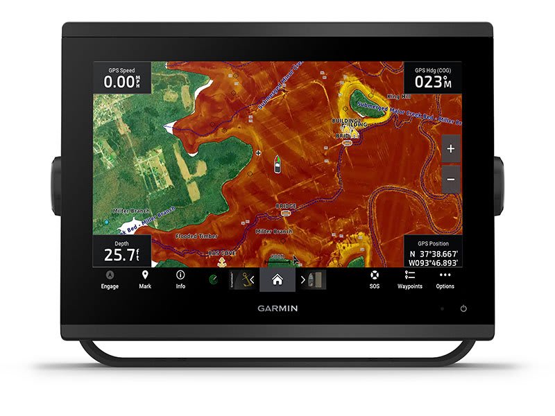
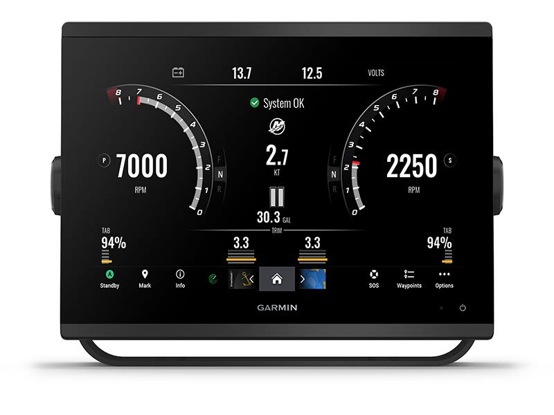
Garmin GPSMAP 1253xsv – GET A SHARPER VIEW FROM YOUR CONNECTED HELM
With its sleek design, powerful processing and upgraded IPS display, this advanced 12″ chartplotter integrates seamlessly into your Garmin marine system.
 Easily integrate with more engines.
 Connect to compatible third-party devices with OneHelm™ digital switching.
 Easily build your marine system using the best of network connectivity.
 Compatible with premium maps and charts1 for the best in Garmin navigation.
 See below your boat with built-in sonar capabilities
 Manage your marine experience from nearly anywhere1.
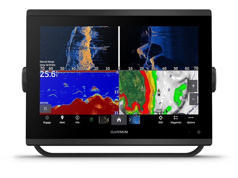
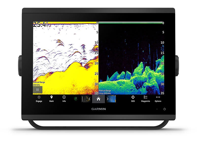
See the world below.
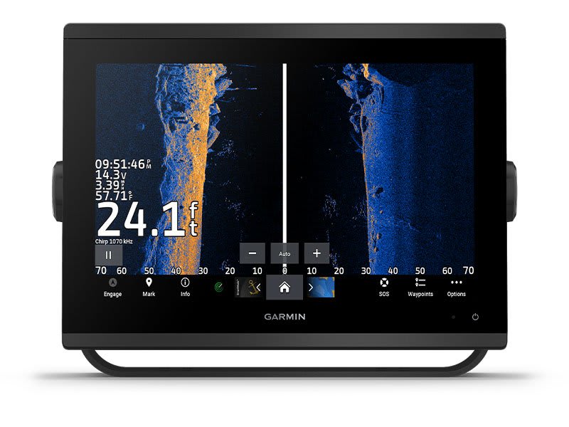
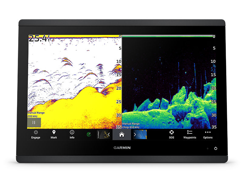
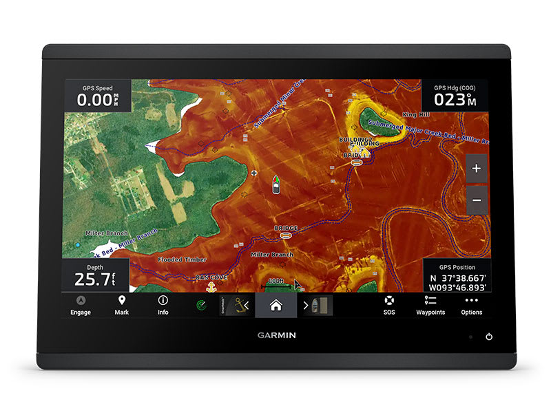
ULTRA HIGH-DEFINITION SCANNING SONAR
Get built-in Ultra High-Definition SideVü and ClearVü scanning sonars with vivid, high-contrast color palettes to help distinguish fish from structure. GPSMAP® X3 series also supports 1 kW CHIRP traditional sonar capabilities. Built-in sonar compatibility only available on xsv models.
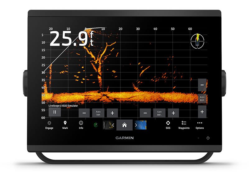
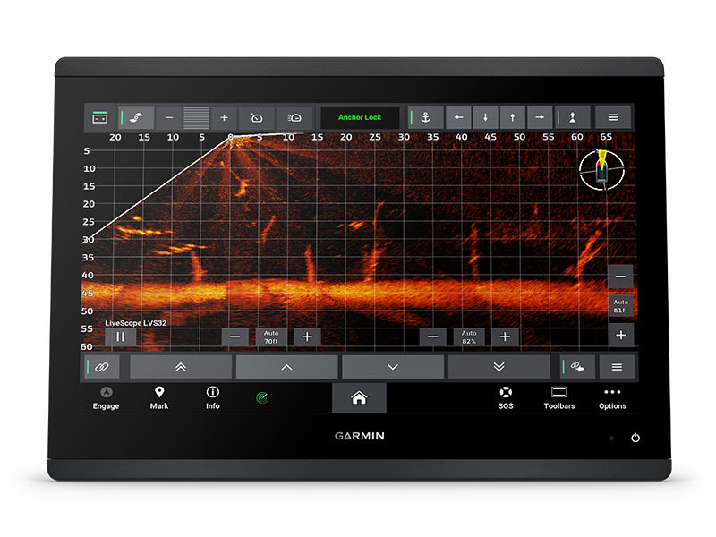
PANOPTIX™ & LIVESCOPE™ SONAR SUPPORT
Pair with Panoptix or LiveScope™ easy-to-interpret live sonar (transducer required, sold separately) to see all around your boat in real time.
Made for your helm.
FASTER, SHARPER, SMARTER
With its added processing power and new slimline design featuring edge-to-edge glass and a smaller unit footprint, it’s easy to retrofit this plotter in a wider range of dash configurations.
IMPROVED DISPLAY OPTICS
New higher-resolution IPS displays for 9″ and 12″ plotters offer improved sunlight readability and visibility from any angle, with 50% more pixels than previous-generation 9″ GPSMAP devices.
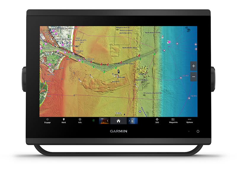
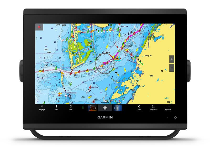
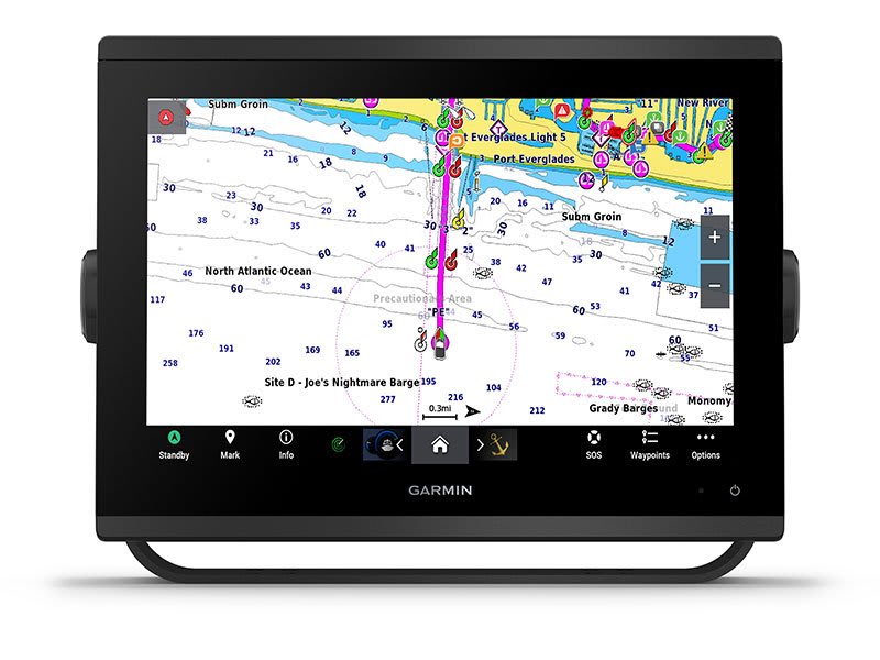
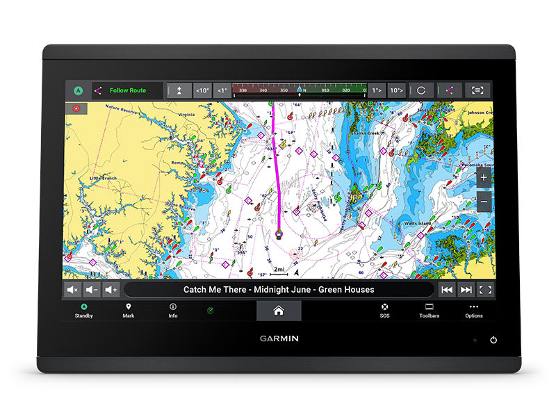
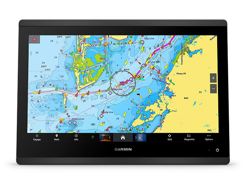
CHARTS AND MAPS
Bring a fresh new look and feel to your chartplotter with optional Garmin Navionics+™ or premium Garmin Navionics Vision+™ cartography featuring integrated coastal/inland content, access to daily updates, Auto Guidance+™ technology3 and more.
OPTIONAL RADAR BUNDLE
To help you avoid weather and traffic on the water, the compact 4 kW GMR™ 18 HD+ dome radar is available as a bundled option with your GPSMAP chartplotter/sonar package.

Sail and navigate with ease.
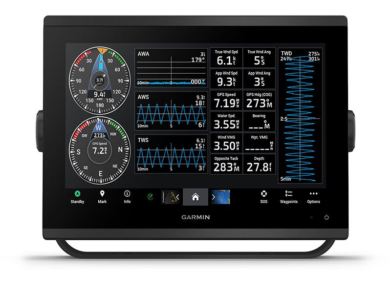
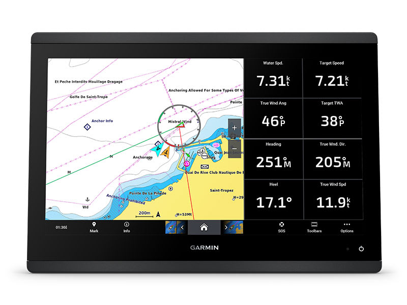
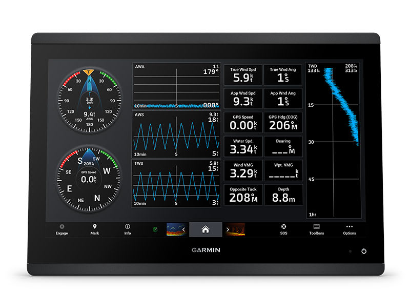
GARMIN SAILASSIST™ SAILING FEATURES
View laylines, race start line guidance, enhanced wind rose, heading and course-over-ground lines, true wind data fields and tide/current/time slider, wind angle, set and drift, wind speed and more.
OPTIONAL PREMIUM NAVIGATION FEATURES
These optional charts offer the best of Garmin and Navionics® data, Auto Guidance3 technology and other premium navigation features.
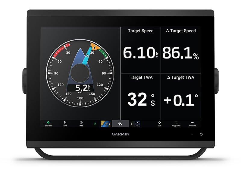
SAILING POLARS
Use the polar table to see key data, including how fast you should go at a certain wind angle and speed — so you know whether you need to adjust sail trim.
GARMIN MARINE NETWORK
If you have multiple compatible Garmin devices on your boat, you can share information — such as maps, user data, radar and IP camera video — among them.
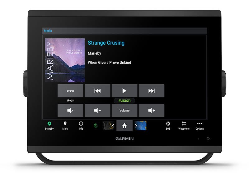
NMEA 2000® AND NMEA 0183 NETWORKS
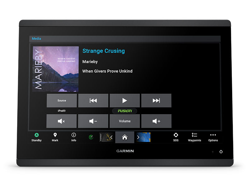
Connect to compatible autopilots, digital switching, weather, Fusion-Link™ audio system, media, VHF, AIS and more from one screen.
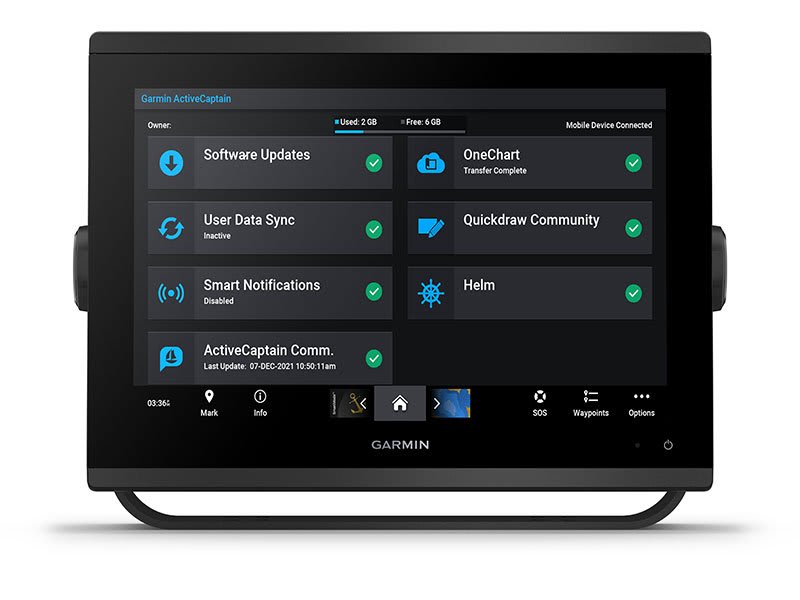
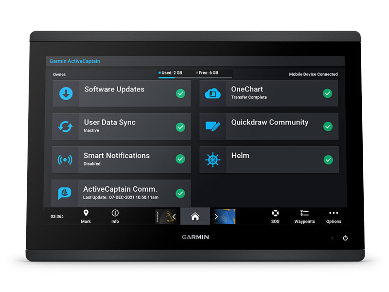
ACTIVECAPTAIN® APP
Built-in Wi-Fi® connectivity pairs with the free all-in-one mobile app for access to the OneChart™ feature, smart notifications, software updates, Garmin Helm™ digital switching, Garmin Quickdraw™ Community 4.
INTEGRATED ANT® TECHNOLOGY
Connect with some of your favourite devices, such as quatix® marine watches, gWind™ Wireless 2 transducers, GNX™ Wind marine instruments and wireless remote controls.
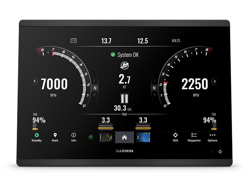
ENGINE CONNECTIVITY
Now you can connect your chartplotter to different kinds of engines, including select Yamaha engines.
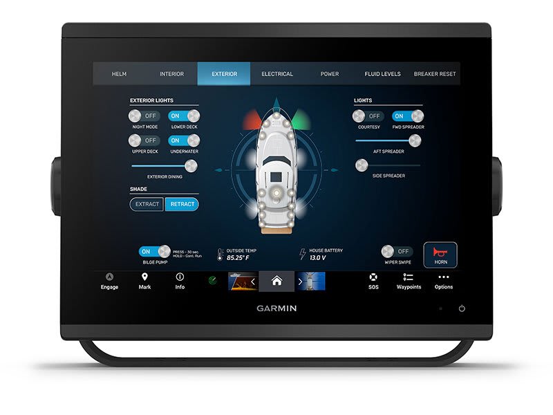
ONEHELM FEATURE
This feature brings together all the operations and capabilities of select third-party devices, such as EmpirBus™ digital switching, on one screen.
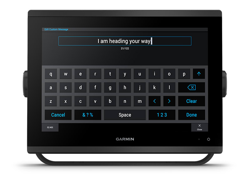
SEND INREACH® DEVICE MESSAGES
Pair your inReach satellite communicator5 to your chartplotter, and type custom messages using your MFD’s on-screen keyboard. Access your contact list or enter an email, inReach address or phone number. You can also group messages by conversation for a texting-like experience.
What’s in the box?
- GPSMAP 1253xsv chartplotter
- microSD™ card preinstalled
- Power cable
- NMEA 2000® T-connector
- NMEA 2000 drop cable (2 meters)
- 8-pin transducer to 12-pin sounder adapter cable
- Bail mount kit with knobs
- Flush mount kit with gasket
- Protective cover
- Trim piece snap covers
- Documentation
View Installation Instructions
View Owner’s Manual
SKU: 010-02367-62 -
EOFY, Garmin, Garmin Chartplotters, Marine Electronics, Sanctuary Cove, Sounders
Garmin GPSMAP 1653xsv – SideVu, ClearVu and Traditional CHIRP Sonar with Mapping
-6% EOFY, Garmin, Garmin Chartplotters, Marine Electronics, Sanctuary Cove, Sounders
Garmin GPSMAP 1653xsv – SideVu, ClearVu and Traditional CHIRP Sonar with Mapping
Garmin GPSMAP 1653xsv – GET A SHARPER VIEW FROM YOUR CONNECTED HELM
With its sleek design, powerful processing and upgraded IPS display, this advanced 16″ chartplotter integrates seamlessly into your Garmin marine system.
 Easily integrate with more engines.
 Easily build your marine system by using our advanced network connectivity.
 Navigate any waters with preloaded Garmin Navionics+™ charts on select models.
 See below your boat with built-in sonar capabilities (only available on xsv models.)
 Manage your marine experience from nearly anywhere1.
See the world below.
ULTRA HIGH-DEFINITION SCANNING SONAR
Get built-in Ultra High-Definition SideVü™ and ClearVü™ scanning sonars with vivid, high-contrast colour palettes to help distinguish fish from structure. The GPSMAP X3 chartplotter series also supports 1 kW traditional sonar capabilities.Built-in sonar compatibility only available on xsv models.
PANOPTIX™ SONAR SUPPORT
Pair with Panoptix™ or LiveScope™ easy-to-interpret live sonar (transducer required, sold separately) to see all around your boat in real time.
Made for your helm.
FASTER, SHARPER, SMARTER
With its added processing power and slimline design featuring edge-to-edge glass, it’s easy to fit this plotter in a wider range of dash configurations.
BRIGHT AND CLEAR OPTICS
High-resolution IPS displays for 16″ chartplotters offer improved sunlight readability and visibility from any angle.
PRELOADED MAPPING
Experience unparalleled coverage and detail with built-in Garmin Navionics+™ integrated coastal and inland mapping that includes Auto Guidance+™ technology2 and a 1-year subscription for downloadable daily updates and more on select chartplotters.
OPTIONAL CHARTS AND MAPS
Bring a fresh new look and feel to your chartplotter with an optional upgrade to a Garmin Navionics Vision+™ premium chart subscription, featuring downloadable relief shading, satellite imagery,
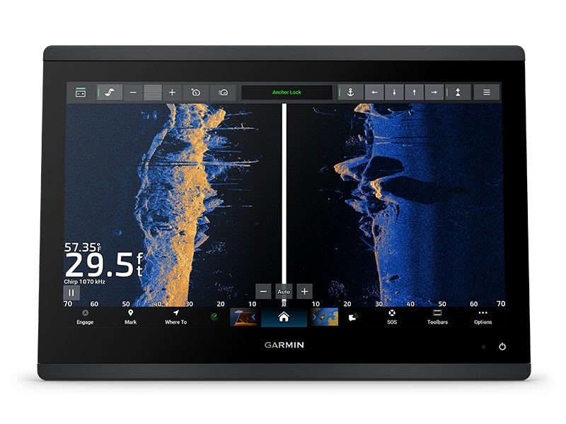
POWER-POLE® SHALLOW WATER ANCHOR
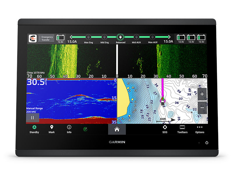
By networking select Garmin chartplotters with a Force® trolling motor and your compatible Power-Pole shallow water anchoring system, you can access advanced boat control features3 from your plotter, including smart anchor auto-deployment, smart anchor jog, auto stow, anchor drag detection and auto guidance2 end-of-route anchoring. Spend more time fishing, less time positioning.
CHARGE INTEGRATION FROM POWER-POLE
Your CHARGE Marine Power Manager from Power-Pole integrates with compatible Garmin chartplotters to help keep your battery power going longer and stronger on the water. You’re able to charge batteries on the run, monitor power use, select where power is allocated, control emergency starts and even transfer power between battery banks — all from your chartplotter display.
OPTIONAL RADAR BUNDLE
To help you avoid weather and traffic on the water, the compact 4 kW GMR™ 18 HD3 dome radar is available as a bundled option with select GPSMAP chartplotter/sonar packages.
TROLLING MOTOR INTEGRATION
Get support and integration for your Force trolling motor (sold separately) to gain complete control while you fish.

Sail and navigate with ease.
GARMIN SAILASSIST™ SAILING FEATURES
View laylines, race start line guidance, enhanced wind rose, heading and course-over-ground lines, true wind data fields and tide/current/time slider, wind angle, set and drift, wind speed and more.
SAILING POLARS
Use the polar table to see key data, including how fast you should go at a certain wind angle and speed — so you know whether you need to adjust sail trim.
GARMIN MARINE NETWORK
If you have multiple compatible Garmin devices on your boat, you can share information — such as maps, user data, radar and IP camera video — among them.
NMEA 2000® AND NMEA 0183 NETWORKS
Connect to compatible autopilots, digital switching, weather, the Fusion audio system, media, VHF, AIS and more from one screen.
ACTIVECAPTAIN® APP
Built-in Wi-Fi® connectivity pairs with the free all-in-one mobile app for access to the OneChart™ feature, smart notifications, software updates, Helm app, Garmin Quickdraw™ Community data and more1.
INTEGRATED ANT® TECHNOLOGY
Connect with some of your favorite devices, such as quatix® marine watches, gWind™ Wireless 2 transducers GNX™ Wind marine instruments and wireless remote controls.
ENGINE CONNECTIVITY
You can connect your chartplotter to different engines, including select Yamaha® engines.
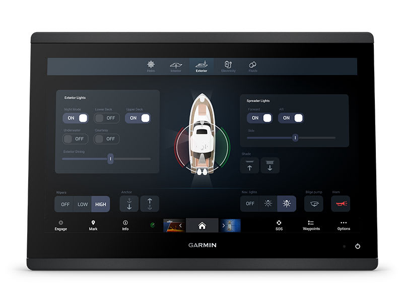
ONEHELM FEATURE
This feature brings together all the operations and capabilities of select third-party devices, such as EmpirBus™ digital switching, on one screen.
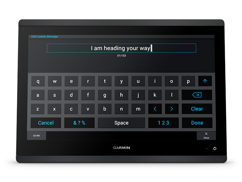
SEND INREACH® DEVICE MESSAGES
Pair your inReach satellite communicator4 to your chartplotter, and type custom messages using your MFD’s on-screen keyboard. Access your contact list or enter an email, inReach address or phone number. You can also group messages by conversation for a texting-like experience.
What’s in the box?
- GPSMAP® 1653xsv Chartplotter
- microSD™ card preinstalled
- 8-pin transducer to 12-pin sounder adapter cable
- Power cable
- Flush mount kit with gasket
- Protective cover
- Trim piece snap covers
- Backbone/drop cable (2 metres) and T-connector for the NMEA 2000® network
- Documentation
View Installation Instructions
View Owner’s Manual
SKU: 010-02919-04 -
Garmin, Garmin Chartplotters, Marine Electronics, Sanctuary Cove, Sounders
Garmin GPSMAP 953xsv
Garmin GPSMAP 953xsv – GET A SHARPER VIEW FROM YOUR CONNECTED HELM
With its sleek design, powerful processing and upgraded IPS display, this advanced 9″ chartplotter integrates seamlessly into your Garmin marine system.
Easily integrate with more engines.
Connect to compatible third-party devices with OneHelm™ digital switching.
Easily build your marine system using the best of network connectivity.
Compatible with premium maps and charts1 for the best in Garmin navigation.
See below your boat with built-in sonar capabilities
Manage your marine experience from nearly anywhere1.
SKU: 010-02366-62 -
Garmin, Garmin Sonar & Transducers, Marine Electronics, Transducers
Garmin GT54UHD-TM Transducer – Ultra High-Definition Scanning Sonar All-in-one Transducer
-8%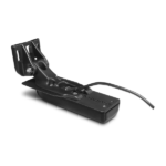 Garmin, Garmin Sonar & Transducers, Marine Electronics, Transducers
Garmin GT54UHD-TM Transducer – Ultra High-Definition Scanning Sonar All-in-one Transducer
Garmin GT54UHD-TM Transducer – Ultra High-Definition Scanning Sonar All-in-one Transducer
All-in-one Transducer
- One transducer provides the highest resolution ClearVü and SideVü scanning sonar images available and amazingly clear high wide CHIRP traditional sonar
- High wide CHIRP traditional sonar provides remarkably clear target separation and definition
- See incredibly detailed images of fish and structure up to 200’ below your boat with 800 kHz ClearVü sonar
- Two SideVü sonar frequency settings (455/1200 kHz) provide options for extended range of up to 500’
- Easy-to-install, compact, all-in-one design includes transom and trolling motor mounts
Ultra-high Clarity
The GT54UHD-TM transducer provides image details so clear and precise, you can actually see fish hanging just off branches of submerged trees, brush and rocks. You can see size differences between bigger and smaller fish and even see individual fish swimming in bait balls. You get the highest resolution ClearVü and SideVü scanning sonar images available plus amazingly clear high wide CHIRP traditional sonar1 — all in one transducer.
Ultra-high Performance
Ultra High-Definition scanning sonar provides extended range and depth performance. It shows you incredibly detailed images of fish and structure up to 200’ below your boat with 800 kHz ClearVü, while two SideVü sonar frequency settings (455/1200 kHz) provide options for extended range of up to 500’. It’s easy to install with included transom and trolling motor mounts so you can start fishing faster.
¹For use with GPSMAP® 8400xsv/8600xsv chartplotter/sonar combos
SKU: 010-12909-000 -
Garmin, Garmin Sonar & Transducers, Marine Electronics, Sanctuary Cove, Transducers
Garmin GT56UHD-TH Transducer
-16% Garmin, Garmin Sonar & Transducers, Marine Electronics, Sanctuary Cove, Transducers
Garmin GT56UHD-TH Transducer
Garmin GT56UHD-TH Transducer – LESS TIME FINDING. MORE TIME FISHING.
This all-in-one transducer offers ultimate versatility, featuring Ultra High-Definition ClearVü and SideVü scanning sonars, high wide CHIRP traditional sonar and more, so you can spend more time catching fish.
See everything below and around your boat with Ultra High-Definition scanning sonar.
High wide CHIRP traditional sonar delivers target separation like no other.

Multiple sonar frequencies have you covered — no matter what depth you’re fishing.

See targets and structure in bright, vivid colour.

Mount this transducer your way — transom, trolling motor or thru-hull.
SKU: 010-02732-10 -
Garmin, Garmin Sonar & Transducers, Marine Electronics, Sanctuary Cove, Transducers
Garmin GT56UHD-THP Transducer
-13%Garmin, Garmin Sonar & Transducers, Marine Electronics, Sanctuary Cove, TransducersGarmin GT56UHD-THP Transducer
Garmin GT56UHD-THP Transducer – LESS TIME FINDING. MORE TIME FISHING.
This all-in-one transducer offers ultimate versatility, featuring Ultra High-Definition ClearVü and SideVü scanning sonars, high wide CHIRP traditional sonar and more, so you can spend more time catching fish.
See everything below and around your boat with Ultra High-Definition scanning sonar.
High wide CHIRP traditional sonar delivers target separation like no other.
Multiple sonar frequencies have you covered — no matter what depth you’re fishing.
See targets and structure in bright, vivid colour.
Mount this transducer your way — transom, trolling motor or thru-hull.
SKU: 010-02732-11 -
EOFY, Garmin, Garmin Sonar & Transducers, Marine Electronics, Sanctuary Cove, Transducers
Garmin GT56UHD-TM Transducer
-7%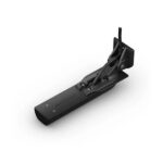 EOFY, Garmin, Garmin Sonar & Transducers, Marine Electronics, Sanctuary Cove, Transducers
Garmin GT56UHD-TM Transducer
Garmin GT56UHD-TM Transducer – LESS TIME FINDING. MORE TIME FISHING.
This all-in-one transducer offers ultimate versatility, featuring Ultra High-Definition ClearVü and SideVü scanning sonars, high wide CHIRP traditional sonar and more, so you can spend more time catching fish.
See everything below and around your boat with Ultra High-Definition scanning sonar.
High wide CHIRP traditional sonar delivers target separation like no other.
Multiple sonar frequencies have you covered — no matter what depth you’re fishing.
See targets and structure in bright, vivid colour.
Mount this transducer your way — transom, trolling motor or thru-hull.
SKU: 010-13073-00 -
Garmin, Garmin Sonar & Transducers, Marine Electronics, Transducers
Garmin GT56UHD-TR Transducer – for 63″ or 75″ Force® Kraken Trolling Motor
-19% Garmin, Garmin Sonar & Transducers, Marine Electronics, Transducers
Garmin GT56UHD-TR Transducer – for 63″ or 75″ Force® Kraken Trolling Motor
Garmin GT56UHD-TR Transducer – for 63″ or 75″ Force® Kraken Trolling Motor
Use this transducer on your compatible Force® Kraken Trolling Motor. Please note, the cable length is designed for Force Kraken trolling motors with factory-installed transducers (black models).
In the box
- GT56UHD-TR Transducer
- Transducer replacement kit
- Mounting hardware
- Documentation
SKU: 010-02732-02 -
Garmin, Garmin Accessories, Garmin Radars, Radars
Garmin Marine Heading Sensor for Radar (Part No. 010-11417-00)
 Garmin, Garmin Accessories, Garmin Radars, Radars
Garmin Marine Heading Sensor for Radar (Part No. 010-11417-00)
Garmin Marine Heading Sensor for Radar [Garmin Part Number: 010-11417-00] – RRP $1200
When interfacing this 3-axis compass heading sensor to our marine lineup of MFDs and radars, mariners can expect unparalleled radar overlay performance and accuracy along with excellent MARPA capabilities.
This heading sensor (based on Airmar H2183) uses a rate gyro, so it can maintain an exceptional 2 degree heading accuracy under heavy dynamic conditions, with up to 30 degrees of pitch and roll. In addition, it supports either NMEA 0183 or NMEA 2000® data output to fit any installation.
Installation is a snap thanks to the heading sensor’s innovative design, allowing it to mount to any angled bulkhead. Mariners can expect this heading sensor to provide trouble-free service in the harshest conditions and will learn to appreciate its reliability and excellent performance.
* Note: NMEA 0183 and NMEA 2000 cables sold separately (to connect to a NMEA 2000 Network a dedicated NMEA 2000 Marine Heading Sensor Cable is required Garmin Part Number: 010-11419-00 – optional, please see related products).
THIS IS SUITABLE FOR CURRENT MODEL GARMIN GMR 18 xHD RADOME & GMR 24 xHD RADOME.
FEATURES:
* Better than 1 degree static heading accuracy
* Industry leading 2 degree dynamic accuracy up to 30 degree pitch and roll
* Three-axis solid-state compass provides accurate heading data
* Three-axis accelerometer improves heading, pitch and roll in static conditions
* Three-axis rate gyro improves heading, pitch and roll in dynamic conditions
* Temperature compensated across the entire operating range to ensure optimum accuracy
* Easy installation to any angled bulkhead
* Auto-calibration featureSPECIFICATIONS:
* Dimensions (HxLxD): 2″ (5.08 cm) x 4.4″ (11.18 cm) x 4.5″ (11.43 cm)
* Default heading output: 10 Hz for both NMEA 0183 and NMEA 2000 (NMEA 2000 can be output up to 20 Hz)
* Waterproof housing: IPX6
* Operating voltage: 9 VDC to 16 VDCWHAT’S IN THE BOX:
* Garmin Marine Heading Sensor
* DocumentationWARRANTY:
We are an authorised Australian Garmin retailer, as such Full Australian Manufacturers Warranty is applicable for this item. Please note if a Garmin unit is purchased overseas or from a non-authorised Garmin retailer you may not receive warranty coverage in Australia.*Specifications from suppliers’ information.
SKU: 010-11417-00 -
EOFY, Garmin, Garmin VHF and AIS, Marine Electronics, Sanctuary Cove, VHF & AIS
Garmin VHF 215i AIS Marine Radio
-10% EOFY, Garmin, Garmin VHF and AIS, Marine Electronics, Sanctuary Cove, VHF & AIS
Garmin VHF 215i AIS Marine Radio
Garmin VHF 215i AIS Marine Radio – Stay in Contact on the Water
- Displays Automatic Identification System (AIS) on the chartplotter
- Standard Class D Digital Selective Calling (DSC) functionality (distress calling and direct calling with user-programmed MMSI)
- In case of trouble, DSC may improve your chances of a rapid rescue
- 25-watt transmit power with built-in GPS
- Frequency bands include all U.S., Canadian and international marine channels plus 10 NOAA weather channels
Communication and situational awareness are critical on the water. This fixed-mount VHF 215i AIS radio displays AIS on the chartplotter to enhance communication, situational awareness and collision avoidance between you and other mariners worldwide.
Increase Your Peace of Mind
During an emergency situation, the 25-watt transmit power of VHF 215i AIS gives fishermen, sailors and cruisers confidence at their fingertips.Communicate Confidently on the Water
Easy to install and use, just plug and play to compatible Garmin chartplotters and MFDs via the NMEA 2000 network. VHF 215i AIS provides standard Class D DSC functionality (distress calling and direct calling with user-programmed MMSI). The radio includes frequency bands for all U.S., Canadian and international marine channels and 10 NOAA weather channels. It’s also NMEA 0183 compatible and includes a two-way hailer system for onboard communication.Communicate with Style
Because your helm is a source of pride, the VHF 215i AIS marine radio is designed to complement the appearance of GPSMAP® 7×2/9×2, GPMAP 10×2/12×2, GPSMAP 7400/7600 and GPSMAP 8400/8600 chartplotters and MFDs.Specs
- Unit Dimensions, HxWxD: 3.9” x 7.8” x 5.8” (9.8 x 19.7 x 14.9 cm)
- Weight: Radio without microphone 42.8 oz. (1.2 kg); Microphone 8.8 oz. (0.25 kg)
- Water rating: IPX7
- Temperature Range: Operating (from -15ºC to 70ºC; from 5ºF to 158ºF); Storage (from -20ºC to 70ºC; from -4ºF to 158ºF);
- Compass-safe Distance: 29.5” (75 cm)
- NMEA 2000: Yes
- NMEA 0183: Yes
- Digital Selective Calling: Class D
- Frequency Bands: All USA, Canadian, and international marine channels; 10 NOAA weather channels
- Operating Voltage: 10.8 – 15.6 Vdc
- Current Draw: Standby 350 mA; Receive 600 mA; Transmit from 2.0 A to 6.0 A (from 1 W to 25 W)
- Frequency Range: 156.050 MHz to 163.275 MHz (including WX channels)
- Hailer Output Power: 20 W at 4 Ω
- Hailer horn impedance: 4 Ω
- External speaker impedance: 4 Ω
- Antenna connector: S0-239 (50 Ω)
- Maximum antenna gain: 9 dBi
 In the Box
- VHF 215i AIS marine radio
- Removable fist mic
- Fist mic mounting bracket and hardware
- Bail mount with knobs and mounting hardware
- Protective cover
- Trim ring snap cover
- Flush mount gasket
- Power cable
- Documentation
SKU: 010-02098-01 -
Garmin, Garmin VHF and AIS, Marine Electronics, Sanctuary Cove, VHF & AIS
Garmin VHF 315i Marine Radio
-9%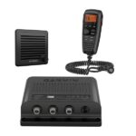 Garmin, Garmin VHF and AIS, Marine Electronics, Sanctuary Cove, VHF & AIS
Garmin VHF 315i Marine Radio
Garmin VHF 315i Marine Radio – Enjoy Reliable Communication
- Reliable 25-watt VHF Class D DSC marine radio
- Includes GHS™ 11 handset and new active speaker to use as intercom between up to 3 stations
- Built-in GPS receiver
- NMEA 2000® connectivity for easy integration with compatible chartplotters and multifunction displays
- Preprogrammed with U.S., Canadian and international marine channels plus 10 NOAA weather channels
The 25-watt VHF 315i marine radio with Class D DSC is a modular communication solution. It provides the security of reliable communication and full NOAA weather alerts on the water by meeting the latest industry standards. It’s easy to use and integrates seamlessly into the Garmin onboard system. It has a built-in GPS receiver with connector for required external antenna. VHF 315i includes a GHS 11 handset and new active speaker to use as an intercom between up to 3 stations. It’s also equipped with a two-way 30-watt hailer system for communication with other boats or deckhands. NMEA 2000 connectivity enables easy integration with compatible chartplotters, multifunction displays and convenient software updates. Simplified handset connectors and an uncomplicated, easy-to-use interface allow you to get your radio set up quickly, so you can get back out on the water and start communicating.
Specs
- Dimensions: 8.1” x 7.1” x 2.4” (20.5 x 18.1 x 6.0 cm)
- Weight: 3.4 lbs. (1.53 kg)
- Operating Temperature Range: 5°F to 158°F (-15°C to 70°C)
- Water rating: IPX7
- Compass-safe Distance: 2” (5 cm)
- Digital Selective Calling: Class D
- Frequency Bands: All USA, Canadian, and international marine channels; 10 NOAA weather channels
- Operating Voltage: 9.6 – 16 Vdc
- Current Draw: Standby: 350 mA; Receive: 600 mA; Transmit High Power: 6 A max; Transmit Low Power: 2 A max
- Transmitter Power (at 13.6 Vdc): High Power: 23-25 W; Low Power: 0.7-1 W
- NMEA 2000 LEN: 1
- NMEA 0183: Yes
In the Box- VHF 315i marine radio
- GHS 11
- Cradle (for GHS 11)
- Active speaker
- Power cable
- Deck cable (10 meters)
- Microphone hanger
- Mounting hardware
- Documentation
SKU: 010-02047-01 -
Marine Electronics, VHF & AIS
GME 1800mm VHF Detachable Antenna Whip
GME 1800mm VHF Detachable Antenna Whip
GME’s range of Australian Made marine VHF antennas lead the market in performance and quality.
Our antennas are designed, engineered, and manufactured to ensure reliability and high performance in the harshest marine environments.
Compatible with GME’s full range of marine VHF radios, these antennas are the perfect addition to any vessel’s communication set up.
Key Features
- White/Black Fibreglass Radome
- Ground Independent Design
- Length: 1800mm
In the box
- Whip only
SKU: GME-AW366V, GME-AW366VB -
Audio, GME, Marine Electronics, VHF & AIS
GME BCV008 – 12V Vehicle Charger suit GX850 DSC Handheld VHF
 Audio, GME, Marine Electronics, VHF & AIS
GME BCV008 – 12V Vehicle Charger suit GX850 DSC Handheld VHF
GME BCV008 – 12V Vehicle Charger suit GX850 DSC Handheld VHF
For over 60 years GME has designed and manufactured an extensive range of high quality accessories to suit a wide variety of applications. From 4WDing to Boating and Fishing, GME has a genuine accessory to meet every need. The BCV008 is a 12V DC Vehicle Charger to suit the GX850W.
Key Features
- 12V DC Vehicle Charger to Suit GX850W
In the box
- Charger Only
SKU: GME BCV008 -
Marine Electronics, VHF & AIS
GME Double Swivel Rectangular Antenna Base – Suit AW36xx Whips
GME Double Swivel Rectangular Antenna Base – Suit AW36xx Whips
The ABL01x Series of Marine antenna bases are designed as a plug and play solution to suit the AW36xx range of Marine Antennas.
Offering a range of designs with single/ double swivel and round/ rectangular base options in both white and black finishes, we have an option to suit every installation.
Key Features
- Suits all AW36XX Antenna Whips
- Double Swivel Adjustment
- Rectangular Mounting Base
- White Nylon
- Coloured Inserts to Identify Frequency
- Ground Independent Design
In the box
- Antenna Base (White)
- 5m Lead Assembly
- Colour Coded Inserts (VHF, AM/FM, 27Mhz)
- FME Connector
Instruction Manual
SKU: GME-ABL012, GME-ABL012B -
Audio, GME, Marine Electronics, VHF & AIS
GME GS620B – 140 Watt ip54 Marine Flush Mount Speakers
GME GS620B – 140 Watt ip54 Marine Flush Mount Speakers
The GS620 flush mount speakers are designed to deliver outstanding audio quality even in the harshest of marine environments.
With a diameter of 188mm, the GS620 flush mount marine speakers are compact yet powerful.
Featuring 140 Watts of power these speakers are the perfect addition to any marine entertainment system.
Available in black (GS620B) or white (GS620W).
- 2 x 140 Watt Flush Mount Speakers
- ASTM B117-03 Salt Spray (Fog) Compliant
- ASTM G154 UV Exposure Compliant
- IP54 Water Ingress Protection
- Impedance: 4 Ohms
- Diameter: 188mm
- 3 Year Warranty
Key Features
- 2 x 140 Watt Flush Mount Speakers
- ASTM B117-03 Salt Spray (Fog) Compliant
- ASTM G154 UV Exposure Compliant
- IP54 Water Ingress Protection
- Impedance: 4 Ohms
- Diameter: 188mm
In the box
- 2 x GS620 Speakers with Grilles
- 2 x 5m Speaker Cable
- Mounting Hardware
- Mounting Template
Instruction Manual
SKU: GME-GS620B -
Audio, GME, Marine Electronics, VHF & AIS
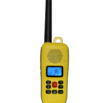
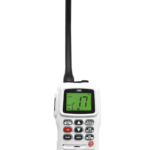
GME GX610 – 2.5W Marine VHF Handheld Radio
GME GX610 – 2.5W Marine VHF Handheld Radio
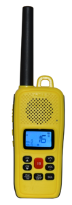
With a proud history of marine safety and communication, GME is pleased to introduce the GX610 Marine VHF Handheld Radio.
Featuring 2.5/ 1 Watt switchable transmission power, IP67 ingress protection, a floating design, and a highly visible yellow finish, the GX610 is ideal for close-range communication on inland waterways and inshore coastal waters.
A large 1600mAh Lithium-Ion (Li-Ion) battery provides an extended operating life and many hours of usage between charges.
The GX610 can be charged using either the built-in USB-C charge port or a desktop charger, ensuring your radio is always ready to go.
- 2.5/1 Watt Switchable Power
- IP67 Ingress Protection
- Large, Bright LCD Display
- Highly Visible Yellow Finish
- USB-C Charging
- Floating Design
- 3 Year Warranty
Key Features
- 2.5/1 Watt Switchable Power
- IP67 Ingress Protection
- Large, Bright LCD Display
- Highly Visible Yellow Finish
- USB-C Charging
- Floating Design
In the box
- VHF Marine Radio (GX610)
- 1600mAh Li-Ion Battery Pack (BP029)
- Desktop Charging Cradle (BCD610)
- USB-C Charging Cable
- 240V AC Power Supply (PS003)
Instruction Manual
SKU: GME-GX610 -
Audio, GME, Marine Electronics, VHF & AIS
GME GX625 – 5/1 Watt Handheld VHF Marine Radio
GME GX625 – 5/1 Watt Handheld VHF Marine Radio
The GX625 is an entry-level portable VHF marine radio that doesn’t sacrifice features or compromise on quality.
Featuring 5/1 Watt switchable transmission power, IP66 ingress protection, dual/ triple watch, programmable scan, and a large bright LCD display the GX625 is ideal for dinghies or tenders that need to keep in touch with the ‘mother ship‘, or small watercraft such as tinnies, kayaks and jet skis that may not have electrical systems or sufficient space for a conventional fixed-mount radio.
The GX625 boasts a class-leading 1200mAh Lithium Ion (Li-Ion) battery pack, providing extended operating life and great stamina for a small handheld radio.
A 240V desktop charger, wrist strap and belt clip are supplied as part of the standard package to ensure the GX625 is always ready to go when you are.
- 5/1 Watt Switchable Transmission Power
- Large, Bright LCD Display
- IP66 Ingress Protection
- Programmable Scan
- International, USA & Canadian Channel Sets
- Flexible, Removable Antenna
- Dual & Triple Watch
- 1 Year Warranty
Key Features
- 5/1 Watt Switchable Transmission Power
- Large, Bright LCD Display
- IP66 Ingress Protection
- Programmable Scan
- International, USA & Canadian Channel Sets
- Flexible, Removable Antenna
- Dual & Triple Watch
- Floats with Auto Flash LCD
In the box
- VHF Marine Radio (GX625)
- High Gain Flexible Antenna (AE4027)
- Li-Ion Battery Pack (1200mAh) (BP025)
- Desktop Charging Cradle (BCD025)
- 240V AC Power Adaptor (PS004)
- Belt Clip (MB625)
- Wrist Strap
Instruction Manual
How to choose your handheld | GME
SKU: GME-GX625 -
Audio, GME, Marine Electronics, VHF & AIS
GME GX625W – 5/1 Watt Handheld VHF Marine Radio
GME GX625W – 5/1 Watt Handheld VHF Marine Radio
Featuring 5/1 Watt switchable transmission power, IP66 ingress protection, dual/ triple watch, programmable scan, and a large bright LCD display, the GX625W is ideal for dinghies or tenders that need to keep in touch with the ‘mother ship‘, or small watercraft such as tinnies, kayaks and jet skis that may not have electrical systems or sufficient space for a conventional fixed-mount radio.
The GX625W boasts a class-leading 1200mAh Lithium-Ion (Li-Ion) battery pack, providing extended operating life and great stamina for a small handheld radio.
A 240V desktop charger, wrist strap, and belt clip are supplied as part of the standard package to ensure the GX625W is always ready to go when you are.
- 5/1 Watt Switchable Transmission Power
- Large, Bright LCD Display
- IP66 Ingress Protection
- Programmable Scan
- International, USA & Canadian Channel Sets
- Flexible, Removable Antenna
- Dual & Triple Watch
- 1 Year Warranty
Key Features
- 5/1 Watt Switchable Transmission Power
- Large, Bright LCD Display
- IP66 Ingress Protection
- Programmable Scan
- International, USA & Canadian Channel Sets
- Flexible, Removable Antenna
- Dual & Triple Watch
- Floats with Auto Flash LCD
In the box
- VHF Marine Radio (GX625W)
- High Gain Flexible Antenna (AE4027)
- Li-Ion Battery (1200mAh) (BP025)
- Desktop Charging Cradle (BCD025)
- 240V AC Power Adaptor (PS004)
- Belt Clip (MB625)
- Wrist Strap
Instruction Manual
How to choose your handheld | GME
SKU: GME-GX625W -
Audio, GME, Marine Electronics, VHF & AIS
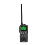
GME GX865 – VHF Marine Handheld Radio
GME GX865 – VHF Marine Handheld Radio

The GX865 radio is ideal for Commercial, Recreational, and Sports use where reliability is essential. Equipped with a robust 5W/1W switchable power transmission, superior IPX8 ingress protection, a built-in torch, float, and flash capabilities, and efficient USB-C charging with a reliable 4000mah battery.
The GX865s also offers WDT (Water Displacement Technology) for unparalleled durability, 60- second channel recording and playback, ultra-long standby time, and dual and triple watch functions for optimal situational awareness. Invest in the GX865 and elevate your marine communication experience to new heights.
- 5/1 Watt Switchable Power
- IPX8 Ingress Protection
- Floats with Auto Flash LCD
- Large LCD with White Background
- Dual & Triple Watch
- Ultra-Long Standby Mode
- Water Displacement Technology
- Voice Record & Loop Play
- 2 Year Warranty
Key Features
- 5/1 Watt Switchable Power
- Torch (White & Red)
- Ultra-Long Standby Mode
- Floats with Auto Flash LCD
- Voice Record and Loop Play
- IPX8 Ingress Protection
- Water displacement Technology
- Large LCD with White Background
- Dual and Triple Watch
In the box
- VHF Marine Radio
- 4000mah Battery (Installed)
- 5v AC/DC power Cable
- Detachable Antenna
- Wrist Strap
- Belt Clip
Instruction Manual
GME’s Marine Radio Range – Handhelds and more!
SKU: GME-GX865