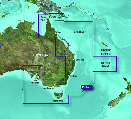
Garmin BlueChart g3 Vision – East Coast of Australia
Price Match
$600.00 $650.00
Premier Coastal Charts
- Exceptional coverage, clarity and detail with updated coastal charts that feature integrated Garmin and Navionics® content
- Auto Guidance¹ technology quickly calculates a suggested route by using your desired depth and overhead clearance
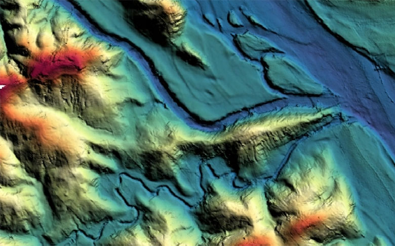
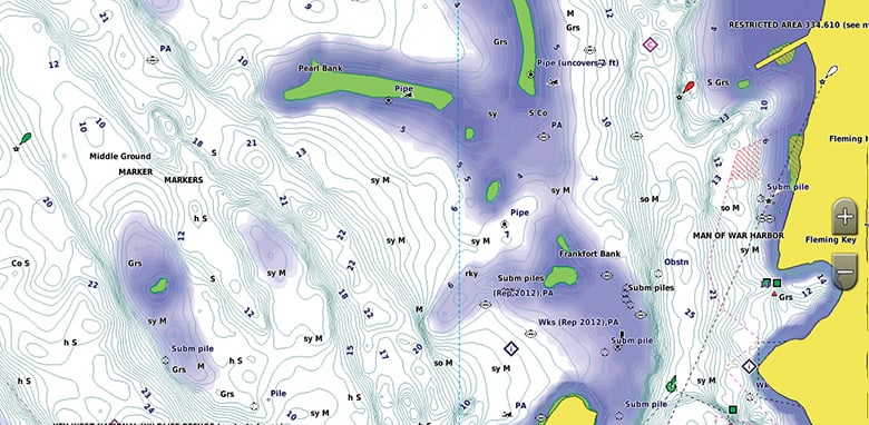
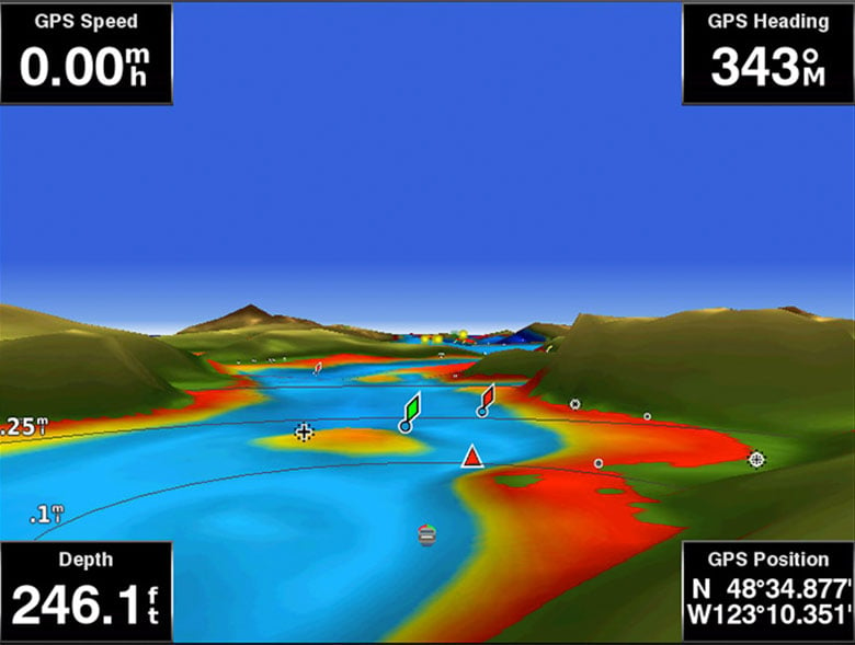
- Certain areas offer high-resolution relief shading, which combines color and shadow to give you an easy-to-interpret, clearer view of bottom structure
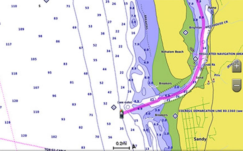
- Includes depth range shading for up to 10 depth ranges, enabling you to view your target depth at a glance
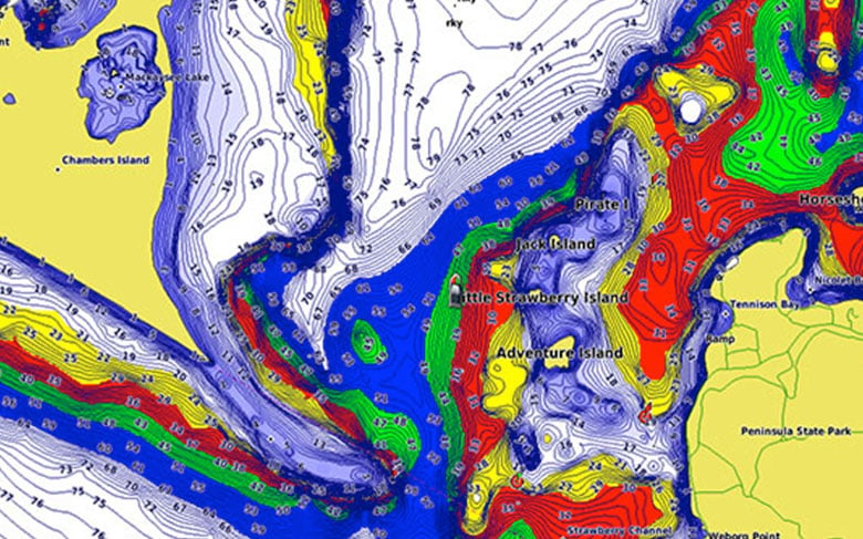
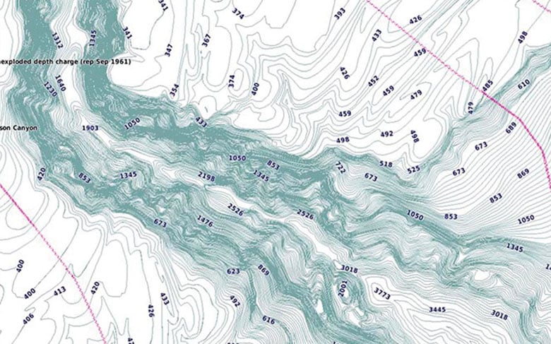
- Up to 1’ contours provide a more accurate depiction of the bottom structure for improved fishing charts
- To give a clear picture of shallow waters to avoid, the Shallow Water Shading allows for shading at a user-defined depth
Experience unparalleled coverage and brilliant detail when you’re on the water. BlueChart g3 Vision coastal charts provide exceptional coverage, clarity and detail with integrated Garmin and Navionics content.
Auto Guidance
Whether you are fishing or cruising, select a spot, and get a route showing you the general path and nearby obstructions at a safe depth1.
High-resolution Relief Shading
With 100% coverage of the continental U.S. coastline, this exceptional shading feature combines color and shadow to give you an easy-to-interpret view of bottom profile, making it easy to find artificial reefs, underwater shelves and more. View coverage areas.
Depth Range Shading
This feature displays high-resolution depth range shading for up to 10 depth ranges so you can view your designated target depth.
Shallow Water Shading
To give a clear picture of shallow waters to avoid, this feature allows for shading at a user-defined depth.
Detailed Contours
BlueChart g3 Vision charts feature 1’ contours that provide a more accurate depiction of bottom structure for improved fishing charts and enhanced detail in swamps, canals and port plans.
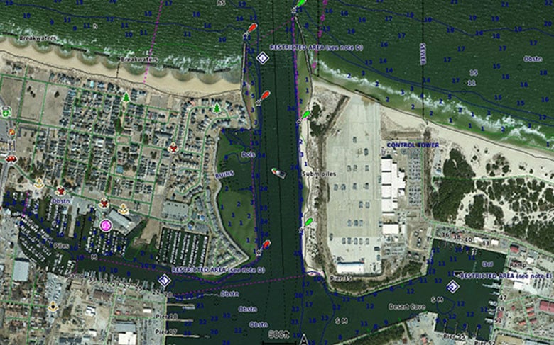
High-resolution Satellite Imagery
High-resolution satellite imagery with navigational charts overlaid gives you a realistic view of your surroundings. It’s our most realistic charting display in a chartplotter — ideal for entering unfamiliar harbors or ports.
FishEye View
This underwater perspective shows 3-D representation of bottom and contours as seen from below the waterline. Interface with sonar data for a customized view.
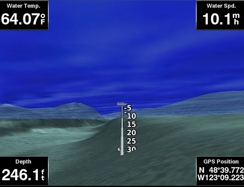
MarinerEye View
This view provides a 3-D representation of the surrounding area both above and below the waterline.
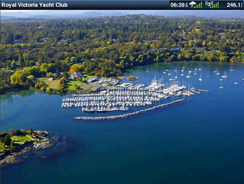
Aerial Photography
Crystal-clear aerial photography shows exceptional detail of many ports, harbors and marinas and is ideal when entering unfamiliar ports.
¹Auto Guidance is for planning purposes only and does not replace safe navigation practices
| Weight | 0.1 kg |
|---|
Based on 0 reviews
Be the first to review “Garmin BlueChart g3 Vision – East Coast of Australia”
You must be logged in to post a review.
Related products
-
Lighting
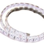
LED Exterior/Interior Strip Light 1m Cool White
LED Exterior/Interior Strip Light 1m Cool White
Super bright multi-purpose LED strip lights available in a range of colours in one and five metre lengths. Features 60 SMD 3528 LED’s per metre set within a clear, low profile, flexible outer casing to provide excellent protection against the elements. Waterproof and rated to IP67.
Each 12 volt strip is pre-wired and may be cut to individual requirements. Supplied with quality ‘3M’ brand self-adhesive tape, plastic mounting clips for added security and additional end caps.
Suitable for marine, outdoor, home, camping, caravan and RV for a wide range of applications. Supplied in bright retail clam packaging.
Features:
Pre-wired and may be cut to individual lengths
Uses quality SMD 3528 LED’s
Ideal for outdoor use, rated to IP67
Long life span with minimal maintenance
Supplied with ‘3M’ self-adhesive tape and mounting clipsBBB Code LED Colour Length metre LED’s per metre Volts LED SMD Type Current draw per metre mHa Lumen per metre BBB-PISL1M3528BLUE Blue 1 60 12 3528 400 180 BBB-PISL1M3528CW Cool White 1 60 12 3528 400 300 BBB-PISL1M3528RED Red 1 60 12 3528 400 180 BBB-PISL1M3528WW Warm White 1 60 12 3528 400 180 SKU: 1M STRIP LIGHT - COOL WHITE -
Lighting
LED Aluminium Slimline Cabin Light (Part # 70998)
LED Aluminium Slimline Cabin Light (Part # 70998)
• Ideal for use in all interior marine, caravan, motorhome and camper
trailer applications. Most commonly used to light up galleys, saloons
and engine rooms.
• Aluminium extrusions with silver plastic end covers.
• 70996: 240 x super bright LEDs.
• 70998: 96 x super bright LEDs.Features:
Part No: 70998
LED Colour: Cool White
Frame Colour: Silver
Length (mm): 300
Height (mm): 90
Thickness (mm): 15
Lumens: 216
Volts: 12
Amps: 0.3
Watts: 3.6SKU: 70998 -
Lowrance Sonar & Transducers, Simrad Sonar & Transducers, Transducers
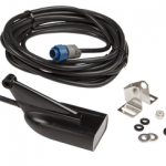
Lowrance Hybrid Dual Imaging (HDI) transducer (83/200/455/800) Transom Mount Depth/Temp Transducer (10976-001)
 Lowrance Sonar & Transducers, Simrad Sonar & Transducers, Transducers
Lowrance Hybrid Dual Imaging (HDI) transducer (83/200/455/800) Transom Mount Depth/Temp Transducer (10976-001)
Lowrance Hybrid Dual Imaging™ (HDI) transducer (83/200/455/800) Transom Mount Depth/Temp Transducer (10976-001)
HDI Skimmer® Transducer
Hybrid Dual Imaging™ (HDI) transducer (83/200/455/800) – The power of two award-winning technologies — Broadband Sounder PLUS Exclusive DownScan Imaging™ — combined to provide the best-possible view beneath your boat.
Transducer Specifications:
* Frequency 83/200/455/800 kHz
* Temperature Sensor Yes
* Mounting Style Transom Mount
* Elements 2Suitable for Lowrance Elite Series: 4 HDI, 4X HDI, 5 HDI, 5X HDI, 7 HDI, 7X HDI, 4x Chirp, 4 Chirp, 5x Chirp, 5 Chirp, 7x Chirp, 7 Chirp, 9x Chirp, 9 Chirp; Lowrance HDS Gen2 & Gen3 Touch Series: HDS 7 Touch, HDS 9 Touch, HDS 12 Touch; Simrad NSS Evo2 Series: NSS7 Evo2, NSS9 Evo2, NSS12 Evo2, NSS16 Evo2.
SKU: 000-10976-001
There are no reviews yet.