-
Garmin, Garmin Chartplotters
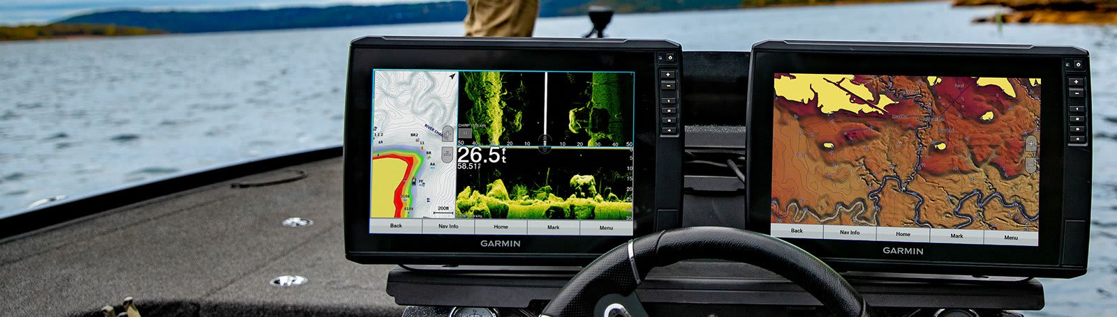
Garmin ECHOMAP™ Ultra 125sv – 12″ Chartplotter with GT56UHD-TM Transducer
-14%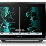 Garmin, Garmin Chartplotters
Garmin ECHOMAP™ Ultra 125sv – 12″ Chartplotter with GT56UHD-TM Transducer
Garmin ECHOMAP™ Ultra 125sv – 12″ Chartplotter with GT56UHD-TM Transducer – ALL THE TOOLS YOU NEED FOR SUCCESSFUL FISHING
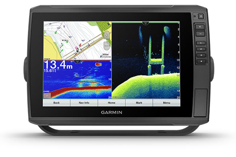
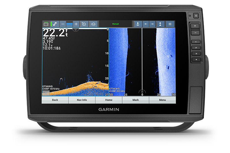
The sunlight-readable 12” touchscreen chartplotter/sonar combo features our Garmin Navionics+™ charts for Australia and New Zealand, plus the transducer bundle adds CHIRP traditional and Ultra High-Definition scanning sonars.

The keyed-assist 12” touchscreen puts fishfinding know-how at your fingertips.

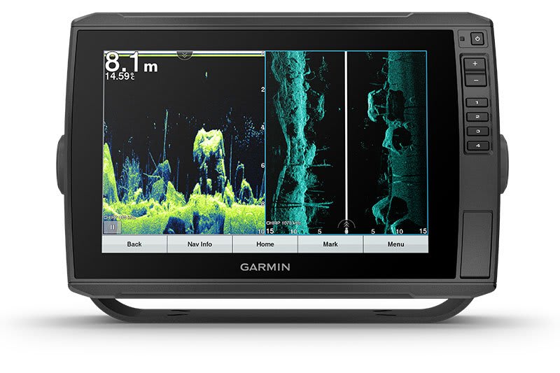
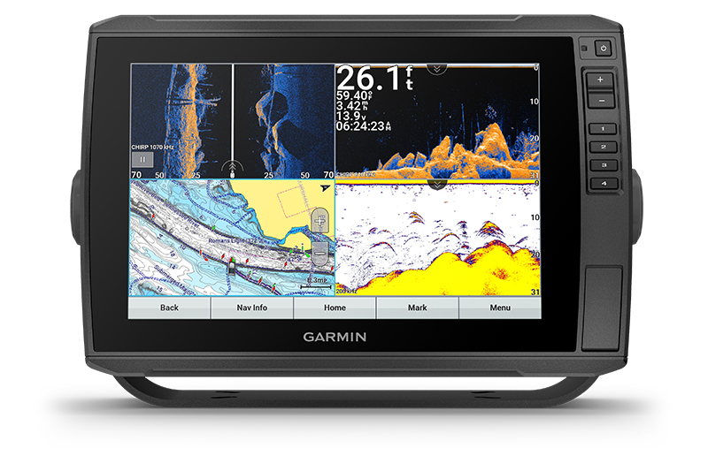
See crisp images of structure and fish in stunning detail.

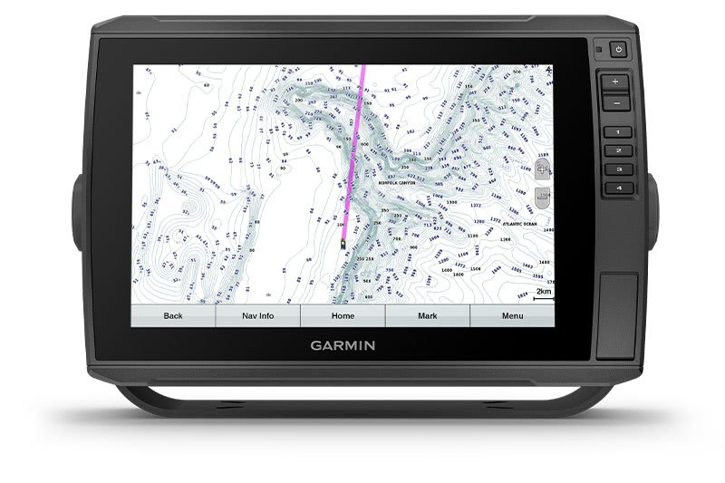
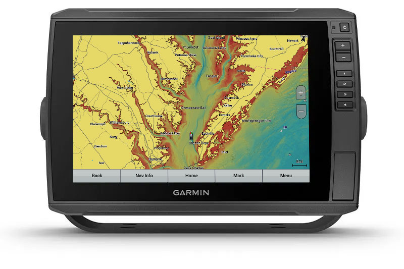
Navigate confidently with built-in Garmin Navionics+™ charts for Australia and New Zealand.

Manage your marine experience from nearly anywhere with the ActiveCaptain® app1.

Connect your boat to share data, sonar and charts with your other compatible devices.

Explore your new favorite spot; create maps on the fly, and tailor them to fit your needs.
SKU: 010-02528-70 -
Garmin, Garmin Accessories
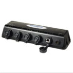
Garmin GMS 10 Network Port Expander
Garmin GMS 10 Network Port Expander
The GMS 10 Network Port Expander allows you to connect multiple chartplotters and sensors over the Garmin Marine Network. With this robust 100-megabit switch, you can connect multiple MFDs and sensors to the Garmin Marine Network and gain the benefit of Ethernet-like data transfer speeds up to 10 times faster than some competitive systems.
Just Plug and Play
The GMS 10 and the Garmin Marine Network are completely plug-and-play, which means that all peripherals are automatically detected and readily accessible once they’re connected to the network. Likewise, you can easily expand your system using the same standard data cable to plug additional units and displays into the GMS 10 network ports.
Waterproof Your Connections
The rugged GMS 10 is specifically designed to withstand the corrosive marine environment. All connections are totally waterproof, and sealed covers keep harmful moisture away from unused data ports.
GMS 10: Expand your network to its fullest potential
SKU: 010-00351-00 -


Garmin ECHOMAP™ Ultra 125sv – 12″ Chartplotter with GT56UHD-TM Transducer
Price Match
$4,199.00 $4,899.00
Garmin ECHOMAP™ Ultra 125sv – 12″ Chartplotter with GT56UHD-TM Transducer – ALL THE TOOLS YOU NEED FOR SUCCESSFUL FISHING
The sunlight-readable 12” touchscreen chartplotter/sonar combo features our Garmin Navionics+™ charts for Australia and New Zealand, plus the transducer bundle adds CHIRP traditional and Ultra High-Definition scanning sonars.
![]()
The keyed-assist 12” touchscreen puts fishfinding know-how at your fingertips.
![]()
See crisp images of structure and fish in stunning detail.
![]()
Navigate confidently with built-in Garmin Navionics+™ charts for Australia and New Zealand.
![]()
Manage your marine experience from nearly anywhere with the ActiveCaptain® app1.
![]()
Connect your boat to share data, sonar and charts with your other compatible devices.
![]()
Explore your new favorite spot; create maps on the fly, and tailor them to fit your needs.
Better fishing comes built-in.
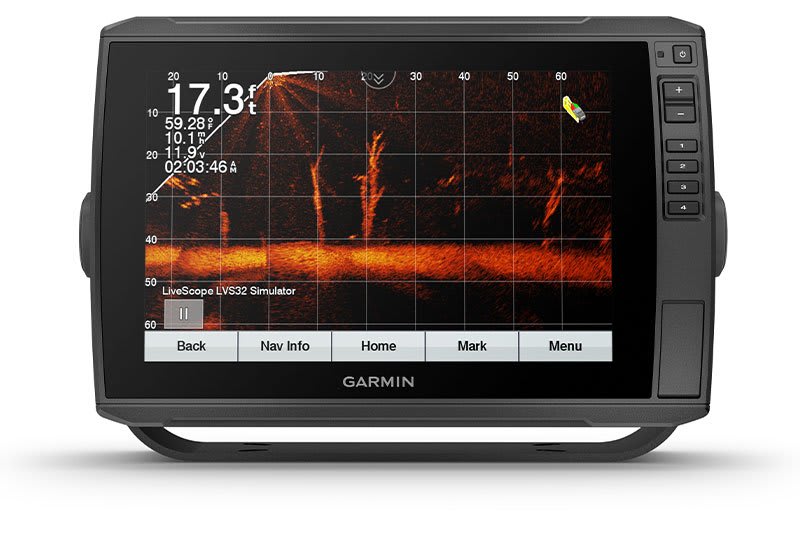
LIVESCOPE™ SONAR SUPPORT
ECHOMAP Ultra supports a variety of Garmin transducers (sold separately), including LiveScope all-seeing live sonar.
BUILT-IN UHD SONAR
Built-in UHD sonar provides Garmin CHIRP traditional sonar plus Ultra High-Definition ClearVü™ and SideVü™ scanning sonars when paired with a compatible UHD transducer. Transducer bundled products include the GT56 transducers with three scanning sonar frequencies and 20% greater range for your UHD SideVü sonar.
VIVID COLOR PALETTES
High-contrast vivid scanning sonar color palettes make it easier than ever to distinguish targets and structure.
PRELOADED CHARTS
Experience unparalleled coverage and detail with preloaded Garmin Navionics+ charts for Australia and New Zealand, featuring integrated coastal and inland lake coverage. It comes with a 1-year subscription for downloadable daily updates and more.
OPTIONAL MAP UPGRADES
Bring a fresh new look and feel to your chartplotter with optional Garmin Navionics Vision+™ premium cartography, featuring high-resolution relief shading, satellite imagery, sonar imagery and more.
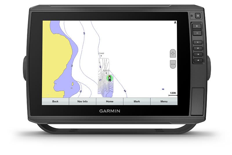
QUICKDRAW CONTOURS
Create personalized fishing maps on-screen with 1’ contours. Keep the data to yourself, or share it with the Garmin Quickdraw™ Community on the Garmin Connect™ app2.

Stay connected on and off the water.
NETWORK CAPABLE
If you have multiple compatible ECHOMAP Ultra 10” or 12” units or ECHOMAP Plus or UHD 7” and 9” units on your boat, you can share information — such as sonar, user data and charts — among them.
NMEA 2000® NETWORK COMPATIBILITY
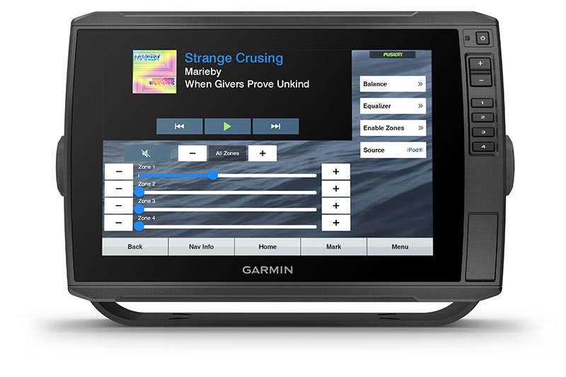
Connect to your compatible autopilots, digital switching, weather, Fusion-Link™ audio system, media, VHF, AIS, engine data, heading sensors — such as the SteadyCast™ sensor — and more from one screen.
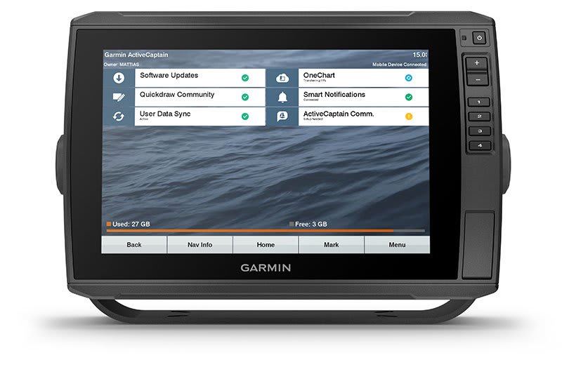
ACTIVECAPTAIN APP
Built-in Wi-Fi® connectivity pairs with the free all-in-one mobile app for access to the OneChart™ feature, smart notifications, software updates, Garmin Quickdraw Community data and more1.
FORCE® TROLLING MOTOR COMPATIBILITY
Take control of the most powerful and efficient trolling motor available3, route it to waypoints, follow tracks and more from the screen of your chartplotter.
TAKE IT WITH YOU
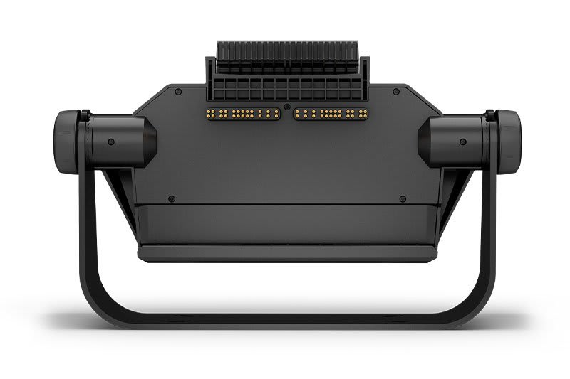
Keep your ECHOMAP Ultra safe and secure. Cords plug directly into the quick-disconnect bail mount, which allows you to quickly install and remove your unit.
What’s in the box?
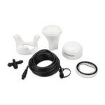
- ECHOMAP Ultra 125sv with Garmin Navionics+
- GT56UHD-TM transducer
- Power/data cable
- Tilt mount with quick release cradle
- Flush mount
- Protective cover
- Hardware
- Documentation
View Installation Instructions
View Owner’s Manual
| Weight | 2.5 kg |
|---|
General |
|
| DIMENSION | 13.4″ x 9.0″ x 3.9″ (341 x 229 x 98 mm) |
| WEIGHT |
5.5 lbs (2.5 kg) |
| WATERPROOF |
IPX7 |
| TOUCHSCREEN | ✔ |
| DISPLAY TYPE | WXGA, IPS |
| DISPLAY SIZE | 10.3” x 6.4”; 12.1″ diagonal (26.1 cm x 16.3 cm; 30.7 cm diagonal) |
| DISPLAY RESOLUTION | 1280 x 800 pixels |
| MOUNTING OPTIONS | Bail or flush |
| INPUT | Touchscreen with Keyed Assist |
Maps & Memory |
|
| ACCEPTS DATA CARDS |
2 microSD™ cards |
| WAYPOINTS | 5000 |
| TRACK POINTS | 50,000 |
| TRACKS | 50 saved tracks |
| NAVIGATION ROUTES | 100 |
Sensors |
|
| GPS | ✔ |
| HAS BUILT-IN RECEIVER | ✔ |
| RECEIVER |
10 Hz |
| NMEA 2000 COMPATIBLE | ✔ |
| NMEA 0183 COMPATIBLE | ✔ |
| SUPPORTS WAAS | ✔ |
Built-in maps |
|
| BUILT-IN AUTO GUIDANCE+ | ✔ |
| GARMIN NAVIONICS+ INLAND & COASTAL | ✔ |
| TIDE TABLES | ✔ |
Optional map support |
|
| GARMIN NAVIONICS+™ | ✔ |
| GARMIN NAVIONICS VISION+™ | ✔ |
| TOPO | ✔ |
| STANDARD MAPPING | ✔ |
| GARMIN QUICKDRAW CONTOURS | ✔ |
Chartplotter Features |
|
| AIS | ✔ |
| DSC | ✔ |
| SUPPORTS FUSION-LINK™ COMPATIBLE RADIOS | ✔ |
| ACTIVECAPTAIN MOBILE PLANNING COMPATIBLE |
yes |
| SAILING FEATURES | ✔ |
Electrical features |
|
| POWER INPUT | 9 to 18 Vdc |
| TYPICAL CURRENT DRAW AT 12 VDC | 2.8 A |
| MAXIMUM CURRENT DRAW AT 12 VDC | 3.0 A |
| MAXIMUM POWER USAGE AT 10 VDC | 24.4 W |
Sonar Features & Specifications |
|
| DISPLAYS SONAR | |
| POWER OUTPUT | 600 W |
| TRADITIONAL SONAR (DUAL FREQUENCY/BEAM) | built-in (single channel CHIRP, 70/83/200 kHz, L, M, H CHIRP) |
| CLEARVÜ | Built-in 260/455/800/1000/1200 kHz |
| SIDEVÜ | Built-in 260/455/800/1000/1200 kHz |
| PANOPTIX™ SONAR | |
| LIVESCOPE | |
Connections |
|
| NMEA 2000® PORTS | 1 |
| CONNECTIONS NMEA0183 INPUT PORTS |
1 |
| NMEA 0183 INPUT (TX) PORTS | 1 |
| GARMIN MARINE NETWORK PORTS |
2 (large connector) |
| 12-PIN TRANSDUCER PORTS | 1 LVS sonar; 1 12-pin scanning sonar |
You may also like…
-
Garmin, Garmin Sonar & Transducers, Marine Electronics, Transducers
Garmin GT56UHD-TM Transducer
-13%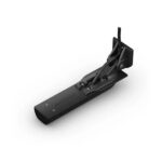 Garmin, Garmin Sonar & Transducers, Marine Electronics, Transducers
Garmin GT56UHD-TM Transducer
Garmin GT56UHD-TM Transducer – LESS TIME FINDING. MORE TIME FISHING.
This all-in-one transducer offers ultimate versatility, featuring Ultra High-Definition ClearVü and SideVü scanning sonars, high wide CHIRP traditional sonar and more, so you can spend more time catching fish.
See everything below and around your boat with Ultra High-Definition scanning sonar.

High wide CHIRP traditional sonar delivers target separation like no other.

Multiple sonar frequencies have you covered — no matter what depth you’re fishing.

See targets and structure in bright, vivid colour.

Mount this transducer your way — transom, trolling motor or thru-hull.
SKU: 010-13073-00 -
Garmin, Garmin Accessories
Garmin GPS 24xd NMEA 2000
Garmin GPS 24xd NMEA 2000 – EXPLORE COASTAL WATERS
The GPS 24xd position receiver and antenna gives you precise location with multi-band GNSS and heading accuracy even at slow speeds.

Navigate in more locations with expanded GNSS support.

Get high-sensitivity tracking with fast GPS update rate.

Accurately pinpoint your heading — regardless of speed.

It’s water-resistant (IPX7) to withstand the elements.
Install it easily with multiple mounting options.

The antenna is compatible with NMEA 2000® devices.
SKU: 010-02316-10 -
Garmin, Garmin Accessories
Garmin Y-cable (12pin transducer + 8-pin transducer to 12 pin Sounder)
Garmin Y-cable (12pin transducer + 8-pin transducer to 12 pin Sounder)
Combine a Garmin transom mount scanning transducer with a Garmin or Airmar in-hull mounted transducer. Use this Y-cable to connect a 12-pin SideVü/Clearvü-only transducer along with an 8-pin 2D-only transducer into a single 12-pin (orange) port on a Garmin SideVü equipped sonar. This adapter cable allows compatible ECHOMAP, GPSMAP or STRIKER family sonar products to continue to display water depth from the in-hull transducer in instances when the transom mount transducer loses depth reading due to excess speed or cavitation.
Y-cable to connect an 8-pin 2-D-only transducer along with a 12-pin SideVü / Clearvü -only transducer into a single 12-pin (orange) port on a Garmin SideVü equipped sonar.

- This cable only works with specific SideVü / Clearvü transducers. There are currently only three of those; the GT30, GT34, and the GT36UHD
- This cable also only works with specific 2-D transducers. There are currently only 5 of those; GT8HW-IH, GT15M-IH, Airmar B60, Airmar P72, and Airmar P79
- Software setup is automatic with the GT8 and GT15. The Airmar transducers require a manual transducer selection
NOTE: This Y-Cable will not work with any GT or CV all-in-one transducer like GT40, GT41, GT50M, GT51M, GT52HW, GT54HW and GT56UHD.
NOTE: When using the 12-Pin + 8-Pin to 12-Pin sounder cable, user must manually select the transducer type they intend to use.
SKU: 010-12445-33 -
Garmin Accessories, Garmin
Garmin NMEA 2000 Starter Kit
Garmin NMEA 2000 Starter Kit
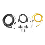
Our starter kit has everything you need to build a basic NMEA 2000 network on your boat. The kit includes an NMEA 2000 drop cable (2 m), backbone cable (6 m), power cable (2 m), 2 T-connectors, and male and female terminator connectors.
SKU: 010-11442-00
Related products
-
Uncategorised
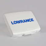
Lowrance Hook-5 / Hook-5x / Elite 5 HDI/5x HDI, 5 Chirp Sun Cover (000-10050-001)
Lowrance Hook-5 / Hook-5x / Elite 5 HDI/5x HDI, 5 Chirp Sun Cover (000-10050-001)
Suits only Lowrance Hook-5, Hook-5x, Elite 5 HDI, Elite 5x HDI, and Elite 5 CHIRP units.
*Specifications from suppliers’ information.
SKU: 000-10050-001AU -
Seating, Seats
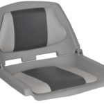
Fisherman Boat Seat Folding Padded – Grey/Charcoal
QUICK OVERVIEW
Made with highly resistant, marine-grade polymer, our low-back fisherman seats are available in 4 varieties.
Low-back, moulded folding seat
High-Impact polymer shell
UV-treated shell resists deterioration and fading
Cushion and back insert upholstered in UV resistant marine-grade vinyl
Suits standard 7″ (175mm) mounts or Titan Swivel
Seat Colour – Grey/Charcoal (others available)SKU: MA702-23 -
Trailer Parts, Wheels
13” Multi Fit 5 Stud HT/FD Trailer Wheel Assembly Galvanised 155LT (Tyre Size: 155LTR13)
 Trailer Parts, Wheels
13” Multi Fit 5 Stud HT/FD Trailer Wheel Assembly Galvanised 155LT (Tyre Size: 155LTR13)
13” Multi Fit 5 Stud HT/FD Trailer Wheel Assembly Galvanised 155LT (Tyre Size: 155LTR13). Suits both HT Holden Hubs and Ford Hubs.
*Specifications from suppliers’ information. This product due to its bulky nature requires an additional surcharge on freight – as a guide freight to South East Queensland [Gold Coast to Sunshine Coast & west to Toowoomba] is approx. $15; Melbourne, Sydney, Adelaide is approx. $20-30; Central & Northern Queensland – Coastal [Bundaberg to Cairns] is approx. $20-30; Perth is approx. $20-30 (we will contact you regarding this depending on location – or simply contact us on 0732658016 for a quote).
SKU: 92755 -
Boating Accessories, Rod Holders
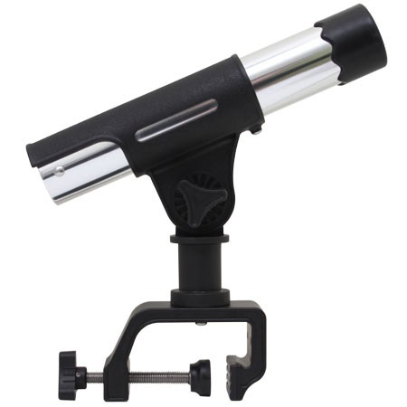
XXX Marine – Tournament Series G-Clamp Rod Holder (RHP300)
XXX Marine – Tournament Series G-Clamp Rod Holder (RHP300)
Ideal for use on boats (clamp to boat side), piers, kayaks etc. Corrosion resistant anodised and polished silver aluminum tube. 360° rotation and with fully adjustable rod angle. Turns through 12 rest position.
Features:
G Clamp mount made from aluminum with 304 stainless steel pressure screw. For boat sides up to 70mm thick.
Rod holder tube length: 280mm
Rod holder tube inner diameter: 41mmSKU: Tournament Series G-Clamp Rod Holder (RHP300)