Northside Marine
Showing 1–30 of 35 results
-
Garmin, Garmin Sonar & Transducers, Sanctuary Cove
Airmar TM185M – Chirp-ready Transom Mount Transducer
-18%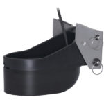 Garmin, Garmin Sonar & Transducers, Sanctuary Cove
Airmar TM185M – Chirp-ready Transom Mount Transducer
Airmar TM185M – Chirp-ready Transom Mount Transducer
Airmar’s TM185M is a transom-mounted, Chirp-ready transducer designed for offshore fishing and freshwater anglers spending their time in shallow to mid-range depths. The medium frequency delivers the right combination of coverage under the boat, extended depth range, and the ability to produce clean and accurate target and structure returns in mid to deeper water. Medium frequency also provides excellent shallow to mid-depth performance, bottom detail, and fish-target separation. Operating at a frequency range of 85 to 135 kHz, this transducer reveals fish at medium depths down to 457 m (1500′) and gives ultra-clear target resolution.
SKU: 010-12810-20 -
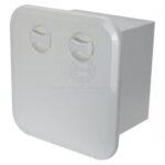
Boating Accessories, Deck Fittings
Ceredi Europa Hatch w Drawers
Ceredi Europa Hatch w Drawers
The new Ceredi Europa hatches are available in two versions; a three drawer and a five drawer. These new hatches are injection moulded in ASA thermoplastic for greater toughness and rigidity. They have outstanding UV resistance to aging and yellowing making them ideal solution for boating and RV use.
• Designed for recess mounting.
• Concealed mounting holes.
• Small Hatch Drawers: 2 x green
1 x red
• Large hatch drawers: 2 x green
3 x red
• Manufactured in ASA plastic and Nylon.
• In-laid gasket ensures a good seal every time.
• Injection moulded tubs and drawers.
• UV resistant.SKU: SAW-38501 -
Garmin, Garmin Radars, Marine Electronics, Sanctuary Cove
Garmin Dome Radar GMR Fantom 18x – 50W 18″ Black
-8%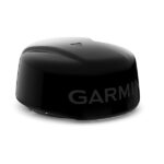 Garmin, Garmin Radars, Marine Electronics, Sanctuary Cove
Garmin Dome Radar GMR Fantom 18x – 50W 18″ Black
Garmin Dome Radar GMR Fantom 18x – STRIKINGLY POWERFUL RADAR
These incredibly powerful 18″ and 24″ dome radars have beauty and brains with a black colour option and 50 watts of output power.

GMR Fantom brings the power. Fifty watts of it, actually.

See targets clearly, and adjust their sizes as needed.

With power save mode, you get to choose when to use full power and when to pull back.

Every second of power usage counts. Cut back even more by choosing your active times down to the second.

MotionScope™ technology shows targets in colour as they move toward you or away.
SKU: 010-02584-10 -
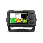
Easter, EOFY, Garmin, Garmin Chartplotters, Sanctuary Cove
Garmin Echomap UHD2 95sv – 9″ Chartplotter with GT56UHD-TM Transducer and Garmin Navionics+ Australia & New Zealand Mapping
-14% Easter, EOFY, Garmin, Garmin Chartplotters, Sanctuary Cove
Garmin Echomap UHD2 95sv – 9″ Chartplotter with GT56UHD-TM Transducer and Garmin Navionics+ Australia & New Zealand Mapping
Garmin Echomap UHD2 95sv – KNOW THE WATER BETTER THAN A LOCAL
When it comes to catching more fish, they say, “Talk to a local.” With the Echomap™ UHD2 95sv chartplotter, which offers our best-in-class sonar and mapping and premium touchscreen display with keyed-assist, you’ll know the water even better than they do.

The bright 6″, 7″ or 9″ touchscreen display with keyed-assist is user-friendly and easy to read.

Good things come in threes. Three sonar types, that is: Garmin traditional, ClearVü™ and SideVü™ sonars.

Improved detail? Check. Distinguished targets? Yep. That’s the beauty of high-contrast vivid colour palettes.

If you’re running another ECHOMAP UHD2 chartplotter, you can wirelessly share sonar, waypoints and routes.

Want our best in mapping? Who doesn’t? Select chartplotters come with Garmin Navionics+™ mapping.
SKU: 010-02690-20 -
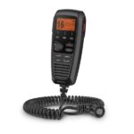
Garmin, Garmin VHF and AIS, Marine Electronics, VHF & AIS
Garmin GHS™ 11i Wired VHF Handset
Garmin GHS 11i allows full function of your compatible VHF radio from a remote location. There are no complex components, just a simple design that includes soft keys, a 2” diagonal dot matrix display and a coiled cable that stretches from about 1’ to nearly 5’.
A rotary/push knob for volume, squelch and channel selection makes it easy to use with a dedicated button for access to channels 16/9. All buttons and knobs resemble those of the VHF radio.
In addition, GHS 11i features a microphone that has intercom capabilities when connected to a speaker.
Specs
- Dimensions: 2.7″ x 6.1″ x 1.6″ (6.9 x 15.4 x 4.0 cm)
- Weight: 0.7 lb. (0.3 kg)
- Operating Temperature Range: 5°F to 158°F (-15°C to 70°C)
- Water rating: IPX7
- Cable length: 1 ft. coiled (5 ft. stretched)
- Compass safe distance: 27” (70 cm)
- Display: Backlit LCD
- Built-in speaker mic: Yes
- 16/9 or 16+ channel button: Yes
- Languages: English, French, Italian, German and Spanish
In the Box
- GHS 11i
- Deck cable (10 meter)
- Microphone hanger
- Mounting hardware
- Documentation
SKU: 010-01759-01 -
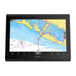
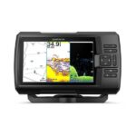
EOFY, Garmin, Garmin Chartplotters, Sanctuary Cove
Garmin GPSMAP 8412xsv – Chartplotter With Worldwide Basemap & Sonar
-10%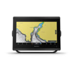 EOFY, Garmin, Garmin Chartplotters, Sanctuary Cove
Garmin GPSMAP 8412xsv – Chartplotter With Worldwide Basemap & Sonar
Garmin GPSMAP 8412xsv – With Worldwide Basemap & Sonar – SERIOUS ANGLERS, CRUISERS, SAILORS AND SAIL RACERS DEMAND SERIOUS EQUIPMENT
The easy-to-use, easy-to-install chartplotter/sonar combo delivers MFD performance in a combo-size package.

Get wider viewing angles and superior clarity on the touchscreen with a full HD in-plane switching (IPS) display.

It’s compatible with premium maps and charts for the best in Garmin navigation.

Easily build your marine system using the best of network connectivity.

See below and around your boat with built-in sonar capabilities (transducers sold separately)

From ANT® technology to Wi-Fi® networking, there are countless ways to connect to your system.

With SmartMode™ station controls, everything is designed to give you quick, one-touch access to the information you need.
SKU: 010-02092-02 -
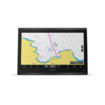
EOFY, Garmin, Garmin Chartplotters, Sanctuary Cove
Garmin GPSMAP 8416xsv – Chartplotter With Worldwide Basemap & Sonar
-10%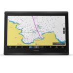 EOFY, Garmin, Garmin Chartplotters, Sanctuary Cove
Garmin GPSMAP 8416xsv – Chartplotter With Worldwide Basemap & Sonar
Garmin GPSMAP 8416xsv – Chartplotter With Worldwide Basemap & Sonar – SERIOUS ANGLERS, CRUISERS, SAILORS AND SAIL RACERS DEMAND SERIOUS EQUIPMENT
The easy-to-use, easy-to-install chartplotter/sonar combo delivers MFD performance in a combo-size package.
Get wider viewing angles and superior clarity on the touchscreen with a full HD in-plane switching (IPS) display.
It’s compatible with premium maps and charts for the best in Garmin navigation.
Easily build your marine system using the best of network connectivity.
See below and around your boat with built-in sonar capabilities (transducers sold separately)
From ANT® technology to Wi-Fi® networking, there are countless ways to connect to your system.
With SmartMode™ station controls, everything is designed to give you quick, one-touch access to the information you need.
SKU: 010-02093-02 -
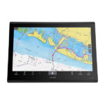
Garmin, Garmin Chartplotters
Garmin GPSMAP 8417 MFD- Chartplotter With Worldwide Basemap
Garmin GPSMAP 8417 MFD- Chartplotter With Worldwide Basemap – TAKE CONTROL OF A BEAUTIFUL HELM
The large-format MFD lets you experience a beautifully powerful, completely networked helm at your fingertips.
Premium full HD touchscreen features Garmin’s highest resolution display.
It’s compatible with premium maps and charts for the best in Garmin navigation.
Easily build your marine system using the best of network connectivity.
From ANT® technology to Wi-Fi® networking, there are countless ways to connect to your system.
Take the guesswork out of sailing with clear laylines and more right on the screen.

With SmartMode™ station controls, everything is designed to give you quick, one-touch access to the information you need.
SKU: 010-01510-00 -
Garmin, Garmin Chartplotters
Garmin GPSMAP 8422 MFD – Chartplotter With Worldwide Basemap
Garmin GPSMAP 8422 MFD- Chartplotter With Worldwide Basemap – TAKE CONTROL OF A BEAUTIFUL HELM
The large-format MFD lets you experience a beautifully powerful, completely networked helm at your fingertips.
Premium full HD touchscreen features Garmin’s highest resolution display.
It’s compatible with premium maps and charts for the best in Garmin navigation.
Easily build your marine system using the best of network connectivity.
From ANT® technology to Wi-Fi® networking, there are countless ways to connect to your system.
Take the guesswork out of sailing with clear laylines and more right on the screen.
With SmartMode™ station controls, everything is designed to give you quick, one-touch access to the information you need.
SKU: 010-01511-00 -
Garmin, Garmin Chartplotters
Garmin GPSMAP 8424 MFD – Chartplotter With Worldwide Basemap
Garmin GPSMAP 8424 MFD – Chartplotter With Worldwide Basemap – TAKE CONTROL OF A BEAUTIFUL HELM
The large-format MFD lets you experience a beautifully powerful, completely networked helm at your fingertips.
Premium full HD touchscreen features Garmin’s highest resolution display.
It’s compatible with premium maps and charts for the best in Garmin navigation.
Easily build your marine system using the best of network connectivity.
From ANT® technology to Wi-Fi® networking, there are countless ways to connect to your system.
Take the guesswork out of sailing with clear laylines and more right on the screen.
With SmartMode™ station controls, everything is designed to give you quick, one-touch access to the information you need.
SKU: 010-01512-00 -
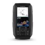
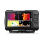
EOFY, Garmin, Garmin Fishfinder, Sanctuary Cove
Garmin STRIKER Vivid 4cv with GT20-TM Transducer
Garmin STRIKER Vivid 4cv with GT20-TM Transducer – THE CHOICE IS YOURS
See fish and structure in maximum detail when you pick your display colour, your location and your sonar for your day on the water with the STRIKER Vivid 4cv fishfinder with transducer.

The sonar colour you pick says a lot about your fishing style. Good thing there are 7 new vivid options.

What a view. Use the included transducer to get CHIRP traditional and ClearVü sonars.

Never lose a hot spot again. Use waypoint marking to find your way back.
What’s under the water’s surface looks pretty good as 1-foot contours, just saying.
SKU: 010-02550-01 -
Garmin, Garmin Fishfinder, Sanctuary Cove
Garmin STRIKER Vivid 5cv with GT20-TM Transducer
Garmin STRIKER Vivid 5cv with GT20-TM Transducer – THE CHOICE IS YOURS
See fish and structure in maximum detail when you pick your display colour, your location and your sonar for your day on the water with the STRIKER Vivid 5cv fishfinder with transducer.
The sonar colour you pick says a lot about your fishing style. Good thing there are 7 new vivid options.
What a view. Use the included transducer to get CHIRP traditional and ClearVü sonars.
Never lose a hot spot again. Use waypoint marking to find your way back.
What’s under the water’s surface looks pretty good as 1′ contours, just saying.
SKU: 010-02551-01 -
EOFY, Garmin, Garmin Fishfinder, Sanctuary Cove
Garmin STRIKER Vivid 7cv with GT20-TM Transducer
Garmin STRIKER Vivid 7cv with GT20-TM Transducer – THE CHOICE IS YOURS
See fish and structure in maximum detail when you pick your display colour, your location and your sonar for your day on the water with the STRIKER Vivid 7cv fishfinder with transducer.
The sonar colour you pick says a lot about your fishing style. Good thing there are 7 new vivid options.
What a view. Use the included transducer to get CHIRP traditional and ClearVü sonars.
Never lose a hot spot again. Use waypoint marking to find your way back.
What’s under the water’s surface looks pretty good as 1-foot contours, just saying.

Wi-Fi® connection1 on land opens up a world of possibilities on the water.
SKU: 010-02552-01 -
Garmin, Garmin Fishfinder, Sanctuary Cove
Garmin STRIKER Vivid 7sv with GT52HW-TM Transducer
Garmin STRIKER Vivid 7sv With GT52HW-TM Transducer – THE CHOICE IS YOURS
See fish and structure in maximum detail when you pick your display colour, your location and your sonar for your day on the water with the STRIKER Vivid 7sv fishfinder with transducer.
The sonar colour you pick says a lot about your fishing style. Good thing there are 7 new vivid options.
What a view. Use the included transducer to get CHIRP traditional and ClearVü sonars.
Never lose a hot spot again. Use waypoint marking to find your way back.
What’s under the water’s surface looks pretty good as 1-foot contours, just saying.
Wi-Fi® connection1 on land opens up a world of possibilities on the water.
SKU: 010-02553-01 -
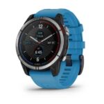
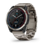
EOFY, Garmin, Garmin Watches
Garmin Watch Quatix 7 – Standard Edition Multisport GPS Watch
Garmin Watch Quatix 7 – Standard Edition Multisport GPS Watch – PLOT YOUR PARADISE ON THE WATER AND BEYOND
With the quatix® 7 multisport GPS smartwatch, you’ll get all the features you need on your boat and the ones you want off it.

Chargers weigh you down, so don’t take one. Go up to 18 days without needing to plug in.

When you own a boat, you want to stay connected. quatix 7 is your answer.

Touch or tap, it’s up to you. Use traditional buttons or the new touchscreen interface.
No matter where you go, know where you are with coastal charts and inland maps.

Kayak or kickbox, SUP or ski, quatix 7 has built-in activity profiles and is made for what you like to do.

Off the grid or at your local spot, text messages and smart notifications1 will be able to find you.
SKU: 010-02540-61 -
EOFY, Garmin, Garmin Watches
Garmin Watch Quatix 7X – Solar Edition Multisport GPS Watch
Garmin Watch Quatix 7X – Solar Edition Multisport GPS Watch – PLOT YOUR PARADISE ON THE WATER AND BEYOND
With quatix® 7X – Solar Edition, the multisport GPS smartwatch with solar charging, you’ll get all the features you need on your boat and the ones you want off it.
Do more. Charge less. Solar charging yields up to 37 days of battery life in smartwatch mode2.
Get a battery boost from the sunlight, so you can go longer between charges.
When you own a boat, you want to stay connected. quatix 7 is your answer.
Touch or tap, it’s up to you. Use traditional buttons or the new touchscreen interface.
No matter where you go, know where you are with coastal charts and inland maps.
Off the grid or at your local spot, text messages and smart notifications1 will be able to find you.
SKU: 010-02541-62 -
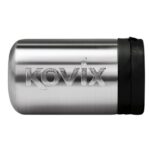
Minn Kota, Minn Kota Accessories
Kovix Minn Kota Bracket Lock
Secure your boat’s electric motor and prevent it from theft with this quality stainless steel lock.
The lock also features a plastic cap to provide maximum water and dust resistance. A 5.5mm cylinder locking pin secures the quick release mounting base, shielding it from cutting and hammering.
Features & Benefits:
• Specially designed to suit MINN KOTA Electric Motors
• Secures the Mounting Base
• Stainless Steel body for durability
• Plastic cap to protect against dust & water
• Can also be used to with the Kovix Hitch PinSKU: 215209 -
Fishfinder / Chartplotter, Lowrance, Lowrance Fish Finders, Marine Electronics
Lowrance HDS LIVE 9 Fishfinder
-23% Fishfinder / Chartplotter, Lowrance, Lowrance Fish Finders, Marine Electronics
Lowrance HDS LIVE 9 Fishfinder
Big enough for use as a standalone display, but compact enough to fit consoles with limited space, the Lowrance HDS LIVE 9 Fishfinder /Chartplotter offers access to the latest Lowrance® fishfinding innovations with support for Active Imaging™, high-resolution ActiveTarget™ Live Sonar, StructureScan® 3D with Active Imaging and Genesis Live onscreen mapping.
SKU: 000-14905-001, 000-14906-001 -
Fishfinder / Chartplotter, Lowrance, Lowrance Fish Finders, Marine Electronics
Lowrance HDS PRO 16 Fishfinder
-17%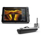 Fishfinder / Chartplotter, Lowrance, Lowrance Fish Finders, Marine Electronics
Lowrance HDS PRO 16 Fishfinder
See more and catch more with the new Lowrance HDS PRO 16 Fishfinder. Watch fish react to your lure live with new, high-resolution ActiveTarget® 2 Live Sonar, and find fish and holding structure with new, ultra-high-definition Active Imaging™ HD. Quickly find fishing areas with the latest and most detailed C-MAP® charts and get full fishing system networking with expanded boat control from bow to stern.
SKU: 000-16007-001, 000-15992-001 -
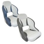
Seating, Seats
Mojo Deluxe Helm Seats
High quality, very comfortable deluxe Helmsman’s seat with full 316 grade stainless steel frame, padded 316 S/S arm rests and fully upholstered with heavy duty marine grade vinyl.
These seats are flat-packed for shipping. They are quick and easy to assemble with fastenings provided.
Features:
- Heavy duty rotomoulded base 20mm thick
- 316 grade stainless steel frame
- Thick foam padding for comfort
- Marine grade heavy duty vinyl upholstery
- Stainless steel arm rests – padded & upholstered
- High level of comfort and support
- Generously sized wide and deep seat
- Designed for mounting to a seat slide only
SKU: RWB-5078 -
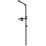
Accessory Mounts, Railblaza
RailBlaza HEXX Live Pole 60
RailBlaza HEXX Live Pole 60
The HEXX Live Pole 60 gives anglers an all-new way to unearth the full potential of their fishfinder. It provides seamless integration with Live Sonar Transducers, allowing you to view more action below the water in real-time. Compatible with Garmin Live Scope, Lowrance Active Target and Humminbird Mega Live, this innovative pole is lightweight and can be easily stowed away when not in use.The pole attaches to the deck, giving it stability and the perfect angle of aim for your transducer. Now it doesn’t matter if you’re operating on a powerboat or a kayak – you’ll always have access to the same level of detail and accuracy as HEXX has been designed with portability in mind. Plus, anglers can appreciate the soft grip handle being situated at hip level to make operation easy and comfortable.Your fishing trips have evolved – so should your electronic mounts. The HEXX Live Pole 60 enables you to get more out of your sonar system than ever before, offering a greater degree of precision that fishermen everywhere will benefit from. Simple to install and quick to remove, it’s ideal for those hoping for increased success when navigating anywhere on the water!SKU: 11-4190-11