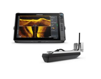
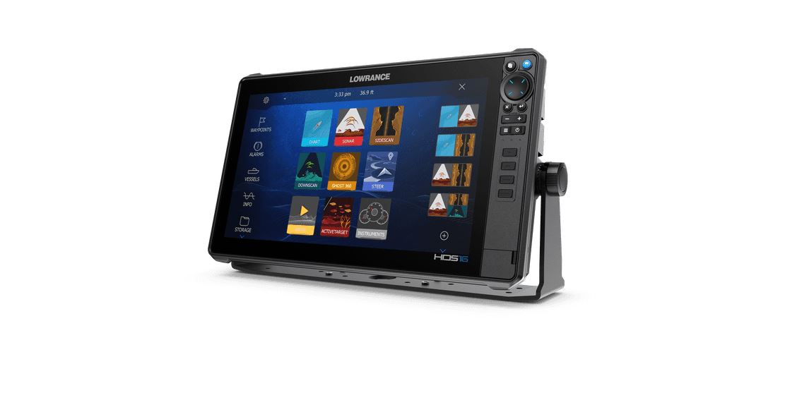
Experience the next level of fishfinding with the new Lowrance HDS PRO 16 Fishfinder, featuring the ultimate clarity of enhanced Lowrance sonar, the latest C-MAP® charts and easy bow-to-stern control.
NEW LOWRANCE SONAR
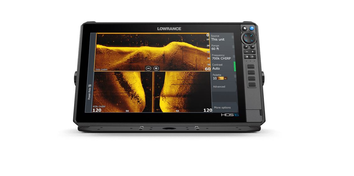
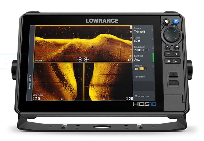
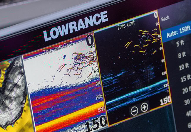
See more and catch more with the new Lowrance HDS PRO 16 Fishfinder, giving you the clearest and most-detailed views with new, higher-resolution ActiveTarget® 2 Live Sonar and new, ultra-high-definition Active Imaging™ HD.
NEW
ACTIVE IMAGING™ HD
Our clearest sonar ever, Active Imaging™ HD delivers high-definition views of Lowrance CHIRP sonar, SideScan and DownScan Imaging™.
FISHREVEAL™
FishReveal™ has also been expanded to be available on SideScan* and DownScan, making fish easier to identify to the sides and beneath the boat.
*SideScan with FishReveal™ requires S3100 module and compatible transducer
NEW
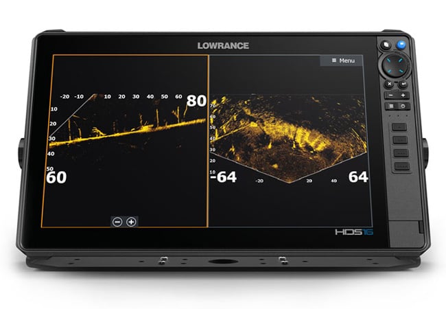
ACTIVETARGET® 2 LIVE SONAR
ActiveTarget® 2 Live Sonar provides higher-resolution views of fish movement and structure.
ADDITIONAL LIVE SONAR VIEWS
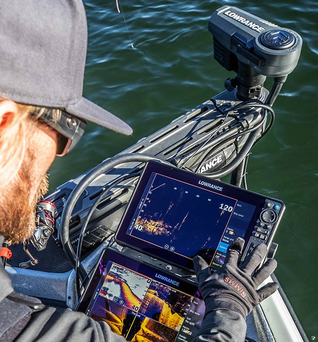
The Lowrance HDS PRO 16 Fishfinder also supports plug-and-play installation of two ActiveTarget® systems, making it possible to watch multiple views simultaneously, and to widen Front and Scout modes for better bait tracking.
C-MAP® NAVIGATION
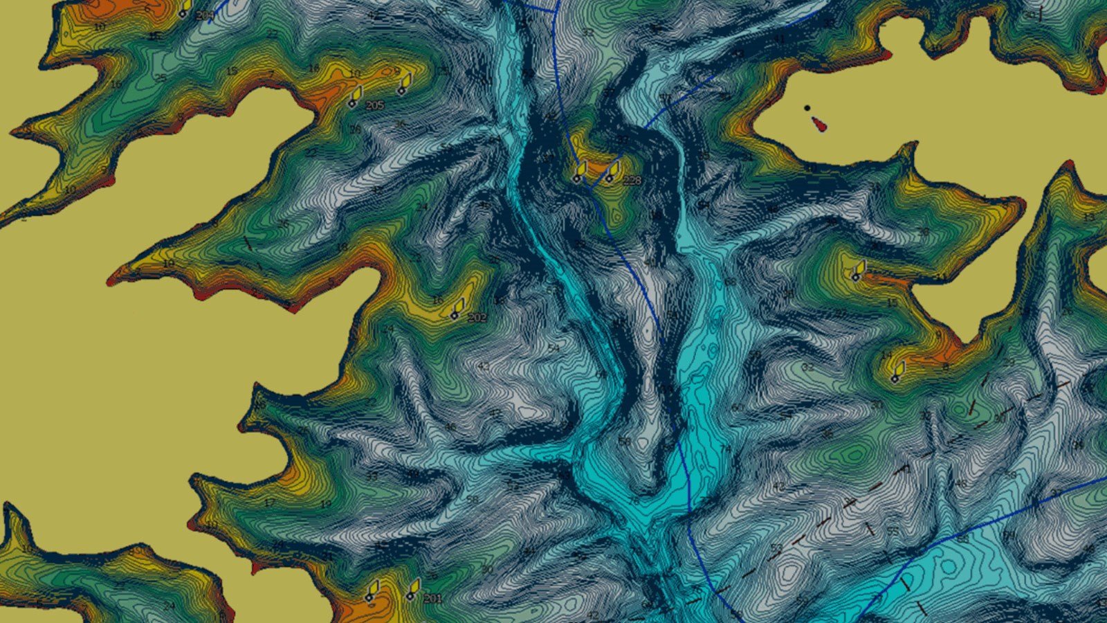
Find great fishing spots with Enhanced Embedded charts for New Zealand and Australia.
ALL THE CHART DETAILS – PRELOADED
Spend more time catching fish and less time finding them, thanks to the detail of C-MAP® inland and coastal charts built into the Lowrance HDS PRO 16 Fishfinder. Enhanced Embedded charts help you find ledges, drop-offs, and ditches – then they help you navigate there with precision.
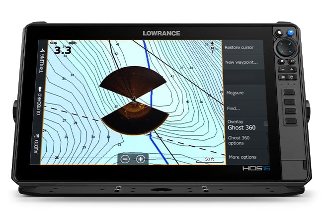
NEW CHART OVERLAY
The Lowrance HDS PRO 16 Fishfinder also introduces a new chart overlay option, allowing you to view ActiveTarget® Scout Mode or Ghost® 360 trolling motor mode directly on the chart screen.
ULTIMATE CLARITY
The better your view, the better your fishing.
From the high-definition touchscreen display to the high-level clarity of the newly-enhanced Lowrance sonar, the Lowrance HDS PRO 16 Fishfinder delivers a full range of meaningful underwater views that will take your fishing experience from good to great.
SOLARMAX™ HD
The SolarMAX™ HD touchscreen provides stunning images of fish, structure and chart details that are easy to see from any angle, in direct sunlight and through polarized lenses – a real difference maker on the water.
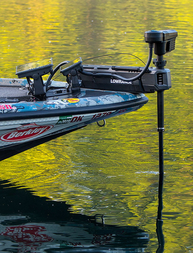
COMPLETE BOW-TO-STERN BOAT CONTROL
The Lowrance HDS PRO 16 Fishfinder gives you full bow-to-stern networking and expanded control of the Ultimate Fishing System.
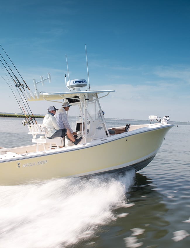
THE ULTIMATE FISHING SYSTEM
With the Lowrance HDS PRO 16 Fishfinder at the heart of your fishing system, it’s easy to customize your boat to fit the way you fish with your choice of fish-finding, navigation, network and entertainment options.
CONNECTIVITY
Expand your system — taking advantage of radar, autopilot and NMEA 2000® compatibility — and add SiriusXM® Weather/Audio to monitor changing weather conditions and to listen to your favourite tunes.
BUILT-IN SUPPORT
The Lowrance HDS PRO 16 Fishfinder offers support for the complete range of top fish-finding technologies – from ActiveTarget® 2 Live Sonar and Active Imaging™ HD to touchscreen control of Ghost® Trolling Motor, Power-Pole® Anchors and more.
Key Features
SolarMAX™ HD Touchscreen viewable at extreme angles and through polarized lenses
New! High-definition up to 1.2MHz Active Imaging™ HD ready (Lowrance CHIRP/SideScan/DownScan Imaging™)
New! High-resolution ActiveTarget® 2 Live Sonar ready
FishReveal™ with new SideScan view, as well as Downscan*
Available in 9, 10, 12 and 16-inch display size
Preloaded C-MAP® Enhanced charts for New Zealand and Australia
Real-time mapping is available with C-MAP® Genesis Live.
Support for new ActiveTarget® Scout and Ghost® Trolling Motor 360 chart overlay views
Large programmable keys for 10, 12 and 16-inch sizes
Touchscreen control of Power-Pole® anchors, Ghost® Trolling Motor, Autopilot and Lowrance Outboard Pilot
NMEA 2000®, Wireless and Bluetooth®, connectivity – plus smartphone notifications
Wide range of optional chart upgrades including C-MAP® REVEAL, Navionics®, Florida Marine Tracks and more.
*SidescanFishReveal requires an S3100 module and a compatible transducer
Integrated Bluetooth 4.0 with support for Bluetooth Classic
Ethernet Ports
2 x 100 Mbit, 6 max MFD’s on a network
Connectivity Wi Fi
Internal 802.11b/g/n and Compatible with WiFi-1 Module
N2K PG Ns
Receive only 65240 ISO Commanded Address, 127245 Rudder, 127251 Rate of Turn, 127257 Attitude, 127488 Engine Parameters, Rapid Update, 127489 Engine Parameters, Dynamic, 127493 Transmission Parameters, Dynamic, 127505 Fluid Level, 127508 Battery Status, 129033 Time and Date, 129038 AIS Class A Position Report, 129039 AIS Class B Position Report, 129040 AIS Class B Extended Position Report, 129794 AIS Class A Static and Voyage Related Data, 129801 AIS Address Safety Related Message, 129802 AIS Safety Related Broadcast Message, 129808 DSC Call Information, 130313 Humidity, 130314 Actual Pressure, 130576 Small Craft Status, 65285 Temperature with Instance, 65325 Reprogramming Status, 65480 Parameter Reply, 130817 Product Information, 130820 Reprogramming Status, 130832 Fuel Used – High Resolution, 130834 Engine and Tank Configuration, 130838 Fluid Level Warning, 130842 AIS and VHF Message Transport, 130843 Sonar Status – Frequency and DSP Voltage Transmit and Receive: 59392 ISO Acknowledgement, 59904 ISO Request, 60160 ISO Transport Protocol, Data Transfer, 60416 ISO Transport Protocol, Connection Management, 60928 ISO Address Claim, 126208 NMEA Group Function, 126464 Receive/Transmit PGN’s group function, 126992 System Time, 126996 Product Information, 127237 Heading/Track Control, 127250 Vessel Heading, 127258 Magnetic Variation, 128259 Speed, 128267 Water Depth, 128275 Distance Log, 129025 Position, Rapid Update, 120296 COG and SOG, Rapid Update, 129029 GNSS Position Data, 129283 Cross Track Error, 129284 Navigation Data, 129539 GNSS DOPs, 129540 GNSS Sats In View, 130074 Route and WP Service – WP List – WP Name and Position, 130310 Environmental Parameters, 130311 Environmental Parameters, 130312 Temperature, 130577 Direction Data, 61184 Parameter Command, 65292 Clear Fluid Level Warnings, 65293 LGC-2000 Configuration, 65323 Data User Group Request, 130831 EP-20 Suzuki Engine and EP-50 Storage Device Configuration, 130835 Set Engine and Tank Configuration, 130839 EP-45 Pressure Configuration, 130840 Data User Group Configuration, 130845 Parameter Handle, 130850 Event Command, 130851 Event Reply Transmit only65287 Temperature Sensor Configuration, 65289 Trim Tab Configuration, 65290 Paddle Wheel Speed Configuration, 130818 Reprogramming Data, 130819 Request Reprogram, 130828 Set Serial Number, 130836 Fluid Level Configuration, 130837 Fuel Flow Turbine Configuration
AIS Chart and Radar overlay. Target vessel details.
Autopilot
Outboard Pilot NAC-1NAC-2 Ghost Trolling Motor Motor Guide Xi5/Xi3 Trolling Motor **requires Motor guide Pinpoint Gateway
Cartography included
C-MAP AUS/NZ Enhanced Base map (AUS/NZ models) C-MAP World Background (ROW models) Navionics base map (AMER and ROW models)
Digital Switching
CzoneNaviop
GPS
10 Hz GPS/GLONASS WAAS/EGNOS/MSAS
Internal Storage
8.0 GB Internal
Multimedia
SonicHubSonicHub2FusionLink products any NMEA 2000 compliant Marine Audio products
Sonar Compatibility
Integrated: CHIRP Broadband Active Imaging Down Scan Active Imaging Side Scan Active Imaging HD Down Scan Active Imaging HD Side Scan Compatible with: ActiveTargetActiveTarget2S3100 SonarHubStructureScanStructureScanHDStructureScan3DLiveSight (requires PSI-1 module)
Waypoints, Routes, Tracks
3000 Waypoints 100 Routes 100 Trails with up to 10,000 points per trail
Weather
SiriusXM via WM-3 (USA only) SiriusXM via WM-4 (USA only)
Physical
Compass Safe
65 cm (2.1 ft)
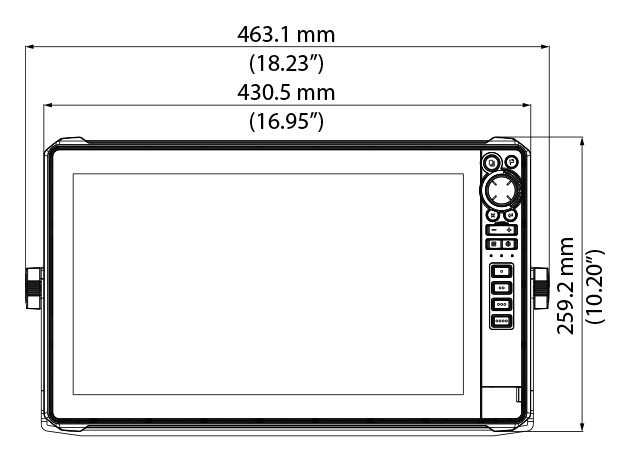
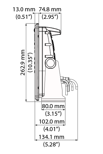
Dimensions W x H x D
16.95″ (430.5 mm) x 10.20″ (259.2 mm) x 3.46 (87.8 mm)
Mounting Type
Gimbal Bracket Front Dash Flush Mount Rear Dash Flush Mount
Weight
7.94 lb (3.60 kg)
Other
Interface
Touch screen: Full Multi-touch touchscreenKeypad:8-way directional keypad Zoom +/-Exit Enter Menu Waypoint Power/Light4 – User Programmable Quick Access Keys
Languages
Standard Language Pack: Afrikaans/Afrikaans, Danish/Dansk, German/Deutsch, English (US), English (UK), Spanish/Español, Finnish/Suomi, French/Français, Greek/Ελληνικά, Icelandic/íslenska, Italian/Italiano, Dutch/Nederlands, Norwegian/Norsk, Portugese (Brazil)/Português (BR), Portugese (Portugal)/Português (PT), Swedish/SvenskaAsian Language Pack: English (US), English (UK), Japanese/日本語, Korean/한국어, Thai/ภาษาไทย, Chinese – (simplified) China/简体中文, Chinese – (traditional) Taiwan/繁體中文Eastern European Language Pack:Bulgarian/Български, German/Deutsch, Estonian/Eesti, English (US), English (UK), Spanish/Español, French/Français, Hebrew/ عبری , Croatian/ Hrvatski, Hungarian/ Magyar, Italian/Italiano, Lithuanian/Lietuvos, Latvian/ Latvijas, Polish/Polski, Slovak/ Slovensky, Turkish/TürkçeRussia/Ukraine Language pack: German/Deutsch, English (US), English (UK), Spanish/Español, Italian/Italiano, Russian/Русский, Ukraine/ УкраїнськаMiddle Eastern Language Pack: Arabic (UAE)/ العربية , German/Deutsch, English (US), English (UK), Farsi/ فارسی , French/Français, Italian/Italiano
Warranty Period
2 Year + 3 additional years of upgrade options Totalling 5 years


 Fishfinder / Chartplotter, Lowrance, Lowrance Fish Finders, Marine Electronics
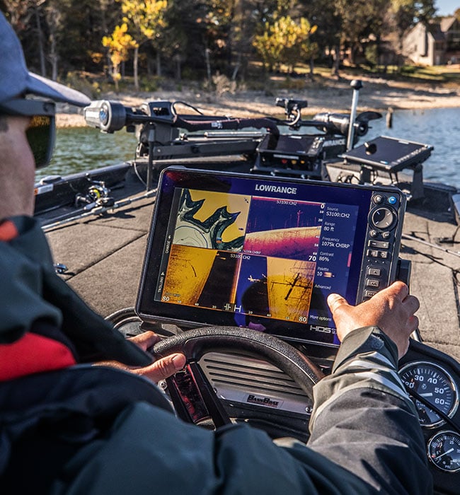

 Lowrance, Lowrance Sonar & Transducers, Marine Electronics, Transducers
 Lowrance, Lowrance Sonar & Transducers, Marine Electronics, Transducers
 Lowrance Sonar & Transducers, Simrad Sonar & Transducers, Transducers
![Raymarine Axiom 7 - 7" Touch Screen Multifunction Navigation with integrated RealVision 3D, 600W Sonar with RV-100 transducer and AUS Mapping [Part Number #E70365-03-AUS]](https://www.northsidemarine.com.au/online-store/wp-content/uploads/sites/9/nc/catalog/Raymarine/Axiom7-tran-150x150.jpg) Marine Electronics, Sounders
Marine Electronics, Sounders Lowrance, Lowrance VHF & AIS, Marine Electronics, VHF & AIS