-
Boat Show Specials, Garmin, Garmin Chartplotters
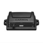
Garmin GPSMAP 8410xsv – Chartplotter With Worldwide Basemap & Sonar
-15%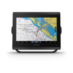 Boat Show Specials, Garmin, Garmin Chartplotters
Garmin GPSMAP 8410xsv – Chartplotter With Worldwide Basemap & Sonar
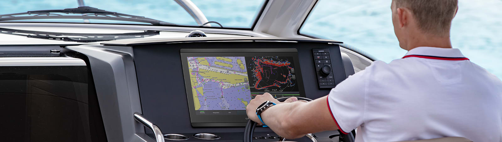
Garmin GPSMAP 8410xsv – With Worldwide Basemap & Sonar – SERIOUS ANGLERS, CRUISERS, SAILORS AND SAIL RACERS DEMAND SERIOUS EQUIPMENT
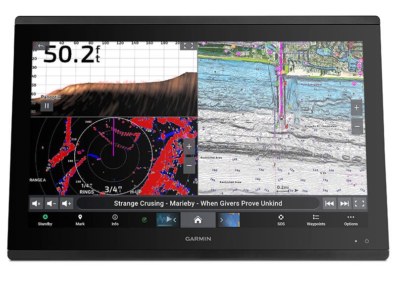
The easy-to-use, easy-to-install chartplotter/sonar combo delivers MFD performance in a combo-size package.

Get wider viewing angles and superior clarity on the touchscreen with a full HD in-plane switching (IPS) display.

It’s compatible with premium maps and charts for the best in Garmin navigation.

Easily build your marine system using the best of network connectivity.

See below and around your boat with built-in sonar capabilities (transducers sold separately)

From ANT® technology to Wi-Fi® networking, there are countless ways to connect to your system.

With SmartMode™ station controls, everything is designed to give you quick, one-touch access to the information you need.
SKU: 010-02091-02 -
Garmin, Garmin Accessories
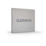
Garmin 10 inch Magnetic Protective Cover for GPSMAP 8410xsv, GPSMAP 8610xsv
 Garmin, Garmin Accessories
Garmin 10 inch Magnetic Protective Cover for GPSMAP 8410xsv, GPSMAP 8610xsv
Garmin 10 inch Magnetic Protective Cover for GPSMAP 8410xsv, GPSMAP 8610xsv
Keep your compatible GPSMAP device safe from the harsh marine environment, when not in use, with this magnetic protective cover.
SKU: 010-12799-10 -
Garmin, Garmin Accessories
Garmin 10 inch Protective Cover for GPSMAP 8410xsv, GPSMAP 8610xsv
Garmin 10 inch Protective Cover for GPSMAP 8410xsv, GPSMAP 8610xsv
Keep your compatible GPSMAP device safe from the harsh marine environment, when not in use, with this plastic protective cover.
SKU: 010-12799-00
")
")
")
")
")
")
")
")
Garmin GPSMAP 8410xsv – Chartplotter With Worldwide Basemap & Sonar
Price Match
$3,899.00 $4,599.00
Garmin GPSMAP 8410xsvGPSMAP 8410xsv – Chartplotter With Worldwide Basemap & Sonar – SERIOUS ANGLERS, CRUISERS, SAILORS AND SAIL RACERS DEMAND SERIOUS EQUIPMENT
The easy-to-use, easy-to-install chartplotter/sonar combo delivers MFD performance in a combo-size package.
![]() Get wider viewing angles and superior clarity on the touchscreen with a full HD in-plane switching (IPS) display.
Get wider viewing angles and superior clarity on the touchscreen with a full HD in-plane switching (IPS) display.
![]() It’s compatible with premium maps and charts for the best in Garmin navigation.
It’s compatible with premium maps and charts for the best in Garmin navigation.
![]() Easily build your marine system using the best of network connectivity.
Easily build your marine system using the best of network connectivity.
![]() See below and around your boat with built-in sonar capabilities (transducers sold separately)
See below and around your boat with built-in sonar capabilities (transducers sold separately)
![]() From ANT® technology to Wi-Fi® networking, there are countless ways to connect to your system.
From ANT® technology to Wi-Fi® networking, there are countless ways to connect to your system.
![]() With SmartMode™ station controls, everything is designed to give you quick, one-touch access to the information you need.
With SmartMode™ station controls, everything is designed to give you quick, one-touch access to the information you need.
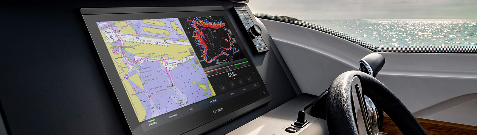
Made for your helm.
HD IPS TOUCHSCREEN
This 10″ display offers wider viewing angles, superior clarity and sunlight readability, even with polarized sunglasses.
SIMPLE, ATTRACTIVE MOUNTING OPTIONS
You can install multiple displays, either flat mounted edge-to-edge for a sleek glass helm look or mounted flush — creating a stunning helm.
GRID™ 20 REMOTE CONTROL
The optional, easy-to-use GRID 20 remote input device provides intuitive remote access and control of your entire Garmin marine system.
See the world below.
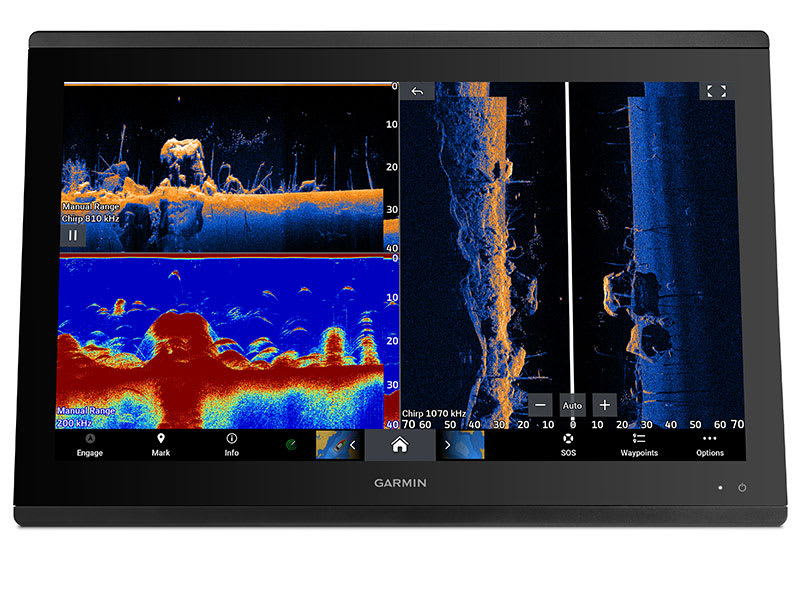
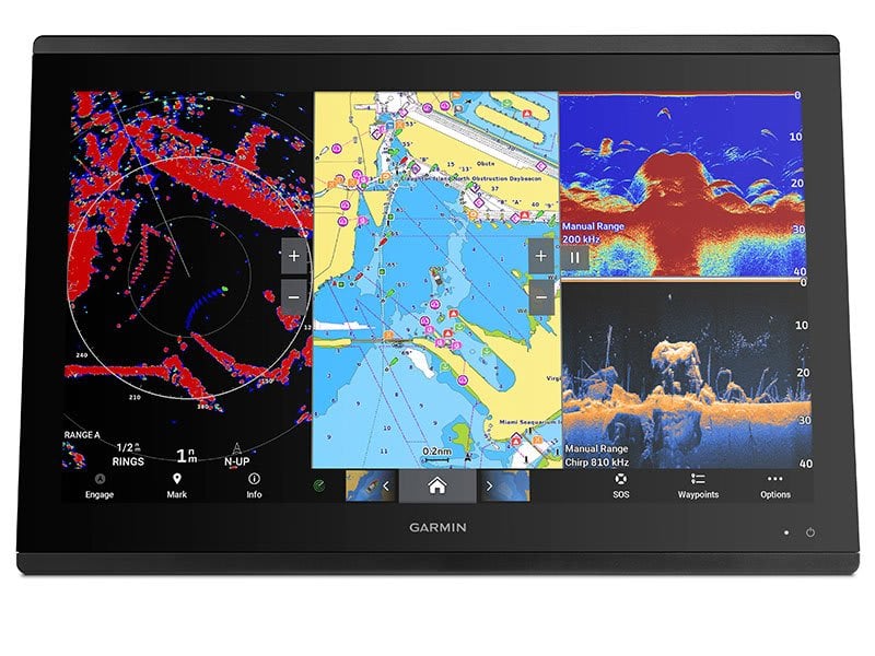
TRADITIONAL AND SCANNING SONAR SUPPORT
Get built-in support for 1-kW Dual-Channel CHIRP traditional sonar for superior target separation and ClearVü and SideVü scanning sonars to see up to 1,000’ below and around your boat at 260 kHz (requires transducer, sold separately). Built-in sonar compabiliity only available on xsv models.
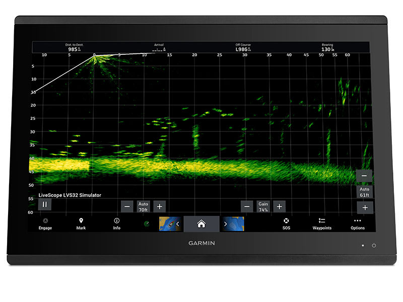
PANOPTIX™ SONAR SUPPORT
Pair your chartplotter with Panoptix or Panoptix LiveScope™ easy-to-interpret live sonar (transducer sold separately) to see all around your boat in real time.

Sail and navigate with ease.
GARMIN SAILASSIST™ SAILING FEATURES
View laylines, race start line guidance, enhanced wind rose, heading and course-over-ground lines, true wind data fields and tide/current/time slider, wind angle, set and drift, wind speed and more.
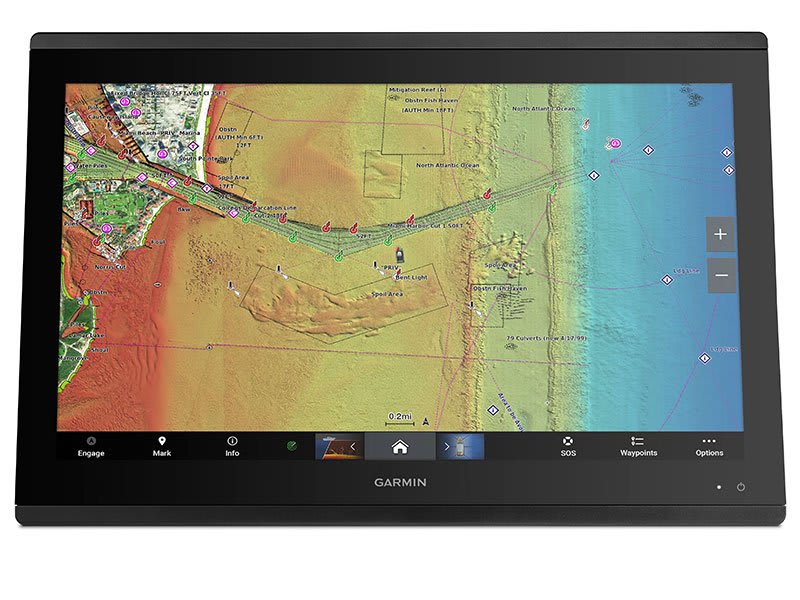
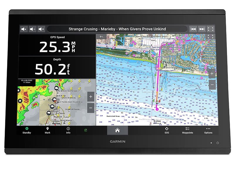
CHARTS & MAPS
Bring a fresh new look and feel to your chartplotter with optional Garmin Navionics+™ or premium Garmin Navionics Vision+™ cartography featuring integrated coastal/inland content, access to daily updates, Auto Guidance+™ technology2 and more.
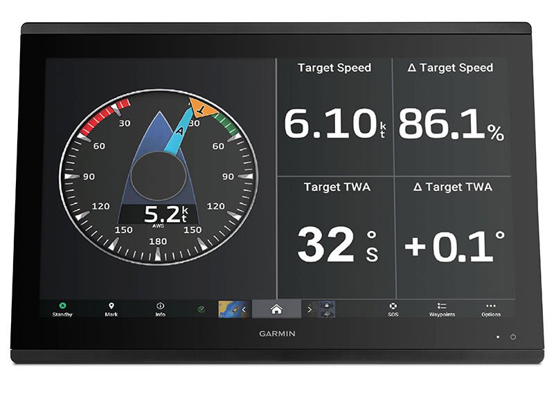
SAILING POLARS
Use the polar table to see key data, including how fast you should go at a certain wind angle and speed — so you know whether you need to adjust sail trim.
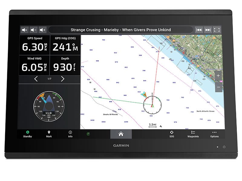
Connect to everything on your boat.
GARMIN MARINE NETWORK
If you have multiple compatible Garmin devices on your boat, you can share information — such as maps, user data, radar and IP camera video — among them.
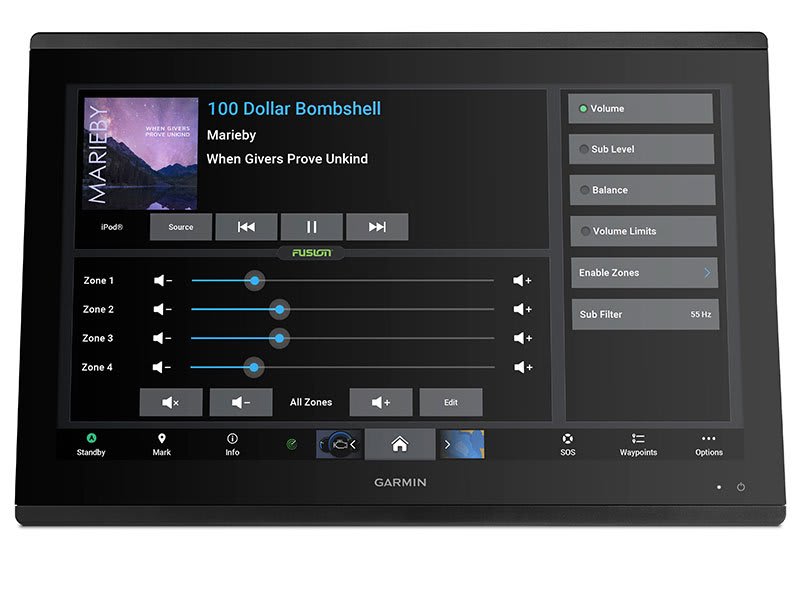
NMEA 2000® AND NMEA 0183 NETWORKS
Connect to autopilots, digital switching, weather, your FUSION-Link™ audio system, media, VHF, AIS and more from one screen.
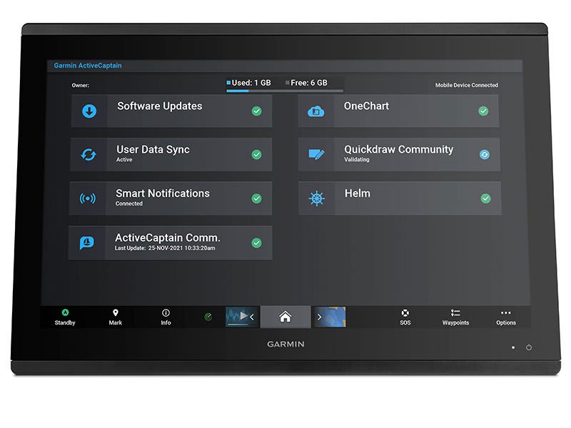
ACTIVECAPTAIN® APP
Built-in Wi-Fi® connectivity pairs with the free all-in-one mobile app for access to the OneChart™ feature, smart notifications3 , software updates, Helm, Garmin Quickdraw™ Community data and more.
INTEGRATED BLUETOOTH® AND ANT TECHNOLOGIES
Connect with some of your favorite devices, such as quatix® marine watches, gWind™ Wireless 2 transducers, GNX™ Wind marine instruments and wireless remote controls.
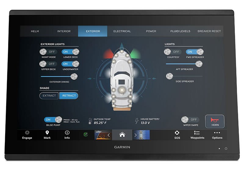
ONEHELM™ FEATURE
This feature brings together all the operations and capabilities of third-party devices, such as EmpirBus™ digital switching, on one screen.
SMARTMODE STATION CONTROLS
Get quick, one-touch access to the information you need to ease high-stress situations such as docking. You can incorporate networked sonar, radar, cameras, media and more.
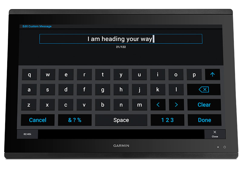
SEND INREACH® DEVICE MESSAGES
Pair your inReach satellite communicator5 to your chartplotter, and type custom messages using your MFD’s on-screen keyboard. Access your contact list or enter an email, inReach address or phone number. You can also group messages by conversation for a texting-like experience.
 What’s in the box?
- GPSMAP 8410xsv
- Power cable
- NMEA 2000® drop cable
- NMEA 2000 T-connector
- Bail mount with knobs
- Flush mount kit
- Sun cover
- Trim piece snap covers
- Documentation
View Owner’s Manual
View Installation Instructions
| Weight | 2.4 kg |
|---|
General |
|
| DIMENSION | 10.25″ x 8.0625″ x 2.95″ (25.9 cm x 20.5 cm x 7.5 cm) |
| WEIGHT |
5.2 lbs (2.4 kg) |
| WATERPROOF |
IPX7 |
| TOUCHSCREEN | ✔ |
| DISPLAY TYPE | WUXGA, IPS |
| DISPLAY SIZE | 8.6″ x 5.4″; 10.1″ diagonal (21.8 cm x 13.7 cm; 25.7 cm diagonal) |
| DISPLAY RESOLUTION | 1920 x 1200 pixels |
| MOUNTING OPTIONS | Bail, flat or flush (Garmin does not offer any hardware or accessories for a flat-mount installation. Professional tools and knowledge is required.) |
Maps & Memory |
|
| ACCEPTS DATA CARDS |
2 microSD cards |
| WAYPOINTS |
5000 |
| TRACK POINTS | 50,000 |
| TRACKS | 50 saved tracks |
| NAVIGATION ROUTES | 100 |
Sensors |
|
| GPS | ✔ |
| GLONASS | ✔ |
| GALILEO | ✔ |
| HAS BUILT-IN RECEIVER | ✔ |
| RECEIVER |
10 Hz |
| NMEA 2000 COMPATIBLE | ✔ |
| NMEA 0183 COMPATIBLE | ✔ |
| SUPPORTS WAAS | ✔ |
Built-in maps |
|
| TIDE TABLES | ✔ |
Optional map support |
|
| BLUECHART G3 | ✔ |
| BLUECHART G3 VISION | ✔ |
| LAKEVÜ G3 | ✔ |
| LAKEVÜ G3 ULTRA | ✔ |
| GARMIN NAVIONICS+™ | ✔ |
| GARMIN NAVIONICS VISION+™ | ✔ |
| TOPO | ✔ |
| STANDARD MAPPING | ✔ |
| GARMIN QUICKDRAW CONTOURS | ✔ |
| RASTER CHART SUPPORT | ✔ |
Chartplotter Features |
|
| SMART MODE COMPATIBLE | ✔ |
| AIS | ✔ |
| DSC | ✔ |
| SUPPORTS FUSION-LINK™ COMPATIBLE RADIOS | ✔ |
| GSD BLACK BOX SONAR SUPPORT | ✔ |
| GCV BLACK BOX SONAR SUPPORT | ✔ |
| ACTIVECAPTAIN MOBILE PLANNING COMPATIBLE | ✔ |
| GRID (GARMIN REMOTE INPUT DEVICE) COMPATIBLE | ✔ |
| WIRELESS REMOTE COMPATIBLE | ✔ |
| SAILING FEATURES | ✔ |
| SPOKEN AUDIO ALERTS | ✔ |
| ONEHELM SUPPORT | ✔ |
Electrical features |
|
| POWER INPUT | 10-32 Vdc |
| TYPICAL CURRENT DRAW AT 12 VDC | 1.5 A |
| MAXIMUM CURRENT DRAW AT 12 VDC | 6.0 A |
| MAXIMUM POWER USAGE AT 10 VDC | 40.1W |
Sonar Features & Specifications |
|
| DISPLAYS SONAR | ✔ |
| POWER OUTPUT | 1 kW |
| TRADITIONAL SONAR (DUAL FREQUENCY/BEAM) | Built-in (dual channel CHIRP, 70/83/200 kHz, L, M, H CHIRP) |
| CLEARVÜ | Built-in 260/455/800/1000/1200 kHz |
| SIDEVÜ | Built-in 260/455/800/1000/1200 kHz |
| PANOPTIX™ SONAR | ✔ |
| LIVESCOPE | ✔ |
Connections |
|
| NMEA 2000® PORTS | 1 |
| CONNECTIONS NMEA0183 INPUT PORTS | 1 |
| NMEA 0183 INPUT (TX) PORTS | 1 |
| VIDEO INPUT PORTS |
1 (BNC composite); 1 HDMI (HDCP compliant) |
| VIDEO OUTPUT PORTS |
1 HDMI |
| J1939 PORTS | 1 |
| GARMIN MARINE NETWORK PORTS |
2 |
| USB PORTS | ✔ |
| BNC EXTERNAL GPS ANTENNA PORT | ✔ |
| BLUETOOTH® PAIRING | ✔ |
| ANT+ (CONNECTIVITY) | ✔ |
| GARMIN WI-FI NETWORK (LOCAL CONNECTION) | ✔ |
You may also like…
-
Garmin, Garmin Accessories
Garmin GRID™ 20 Remote Control
Garmin GRID™ 20 Remote Control – Sit Back and Take Control
- Provides intuitive, easy-to-use remote access and control of your entire Garmin marine system
- 360-degree, all-in-one joystick with a rotary knob and push-to-select button
- Enables easy chartplotter menu/setting navigation and fine control, even in the worst conditions
- 4 favorite keys can be designated to restore your system to a previously saved configuration
- Allows wired or wireless installation options
The easy-to-use GRID 20 remote input device provides intuitive remote access and control of your entire Garmin marine system. It features a 360-degree joystick with a rotary knob and push-to-select button for easy chartplotter menu/setting navigation and fine control, even in the worst conditions. You can designate 4 favourite keys to restore your system to a previously saved configuration. There are also a variety of hard keys for quick access to important functions, including left and right screen switches, autopilot standby/engage and more. For peace of mind, there’s also a dedicated SOS key. Wired or wireless installation and vertical or horizontal options allow for a plug-and-play solution that is tailored to your marine system. Its small footprint makes it convenient to integrate into a busy helm between displays — or even into the arm of the captain’s chair.
What’s in the box?
- GRID 20
- Mounting hardware
- Power cable
- Documentation
SKU: 010-02011-00, 010-02011-01 -
Garmin, Garmin Accessories
Garmin GND™ 10 Black Box Bridge
Garmin GND™ 10 Black Box Bridge
- Converts data between the Nexus network and NMEA 2000®
- Provides compatibility between Nexus and Garmin products
- Simple plug-and-play installation between Nexus, NMEA 2000 and USB
- No user setup or system configuration required
- Allows PC applications, such as NexusRace™, Expedition, Adrena or SeaTrack, to communicate sailing-specific functions between Nexus and NMEA 2000 networks
The GND 10 black box bridge seamlessly integrates Nexus instruments and sensors with the Garmin family. It converts data between the Nexus Network and NMEA 2000 to provide compatibility between Nexus and Garmin products, including gWind™ and gWind™ Race transducers. Simple plug-and-play installation between Nexus and NMEA 2000, with USB connectivity, eliminates the need for user setup and system configuration.
GND 10 allows PC applications, such as NexusRace, Expedition, Adrena or SeaTrack, to communicate sailing-specific functions between Nexus and NMEA 2000 networks. It also enables GND 10 software updates over NMEA 2000. Existing NexusRace PC application can be used to update software, configure and calibrate Nexus devices over USB using the FDX protocol.
SKU: 010-01226-00 -
Garmin, Garmin Accessories
Garmin 9-axis Heading Sensor
Garmin 9-axis Heading Sensor
Premium Solution for Exceptional Heading Accuracy
- Provides exceptional heading accuracy, even at lower speeds or when bow is pitching, rolling or heeling over
- Heading accuracy of plus or minus 2 degrees
- Heading and rate-of-turn output at 10 Hz; trim and heel output at 1 Hz
- Simple 2-step calibration process
- 9-axis MEMS technology allows installation in any orientation located away from magnetic interference
The 9-axis heading sensor is our premium solution that is easy to install and provides fast calibration and exceptional heading accuracy.
Accurate Heading Even at Low Speed
Its heading output at 10 Hz and accuracy of plus or minus 2 degrees ensures your chart orientation and boat heading line match up with reality, even at lower speeds. It also allows for MARPA tracking and improves radar overlay experience.
Effective in Rough Waters
You can also be confident your heading information will remain accurate, even in rough sea conditions where your bow is pitching and rolling or — in sailboat applications — when heeled over. Provides heading and rate-of-turn output at 10 Hz and trim and heel output at 1 Hz.
Easy Installation, Fast Calibration
The 9-axis heading sensor installs easily with NMEA 2000® plug-and-play interface and a simple 2-step precision calibration process for compatible Garmin chartplotters. For displays other than Garmin, basic calibration is also supported. The heading sensor’s 9-axis MEMS technology allows installation in any orientation located away from magnetic interference. All of our heading sensors are built to withstand bilge environments.
What’s in the box?
- 9-axis Heading Sensor
- NMEA 2000® T-connector
- NMEA 2000 drop cable (2 meters)
- Documentation
Installation Instructions
SKU: 010-11417-20 -
Garmin, Boat Show Specials, Garmin Accessories
Garmin GPS 24xd NMEA 2000 – White
Garmin GPS 24xd NMEA 2000 – EXPLORE COASTAL WATERS
The GPS 24xd position receiver and antenna gives you precise location with multi-band GNSS and heading accuracy even at slow speeds.

Navigate in more locations with expanded GNSS support.

Get high-sensitivity tracking with fast GPS update rate.

Accurately pinpoint your heading — regardless of speed.

It’s water-resistant (IPX7) to withstand the elements.

Install it easily with multiple mounting options.

The antenna is compatible with NMEA 2000® devices.

More accurate data — for more confident navigation.
MULTI-BAND GNSS
Multi-band GNSS provides precise location accuracy1 to within 1 metre to compatible marine multifunction displays, instrument displays and autopilots.
MAGNETIC HEADING
The magnetic heading sensor provides accuracy to within 3 degrees, stabilising charts, radar overlay and MARPA even at slow speeds.
HIGH-SENSITIVITY GPS
Fast 10 Hz position update rates provide high-sensitivity position, velocity and time data.
EXPANDED GNSS SUPPORT
GPS 24xd provides access to four key global navigation satellite systems (GPS, Galileo2, GLONASS and BeiDou2) to more accurately track in challenging conditions than GPS alone.
MULTI-SBAS COMPATIBLE
Multi-SBAS compatibility corrects signal measurement errors and provides information about the accuracy, integrity, continuity and availability of its signals.
MOUNTING OPTIONS
Installation is easy with under-deck, pole and surface-mount options.
11 < 1 metre CEP, < 3 metres 95%2Supported when available What’s in the box?
- GPS 24xd NMEA 2000®
- Pole mount
- Surface mount
- Under-deck mount
- NMEA 2000 backbone/drop cable (6 metres)
- NMEA 2000 T-connector
- Documentation
Installation Instructions
Setting Up A NMEA Network and Installing a Garmin GPS 24XD on a boat
SKU: 010-02316-10
Related products
-
Trailer Parts, Wheels
13” Multi Fit 5 Stud HT/FD Trailer Wheel Assembly Galvanised 165 (Tyre Size: 165R13C)
 Trailer Parts, Wheels
13” Multi Fit 5 Stud HT/FD Trailer Wheel Assembly Galvanised 165 (Tyre Size: 165R13C)
13” Multi Fit 5 Stud HT/FD Trailer Wheel Assembly Galvanised 165 (Tyre Size: 165R13C). Suits both HT Holden Hubs and Ford Hubs.
*Specifications from suppliers’ information. This product due to its bulky nature requires an additional surcharge on freight – as a guide freight to South East Queensland [Gold Coast to Sunshine Coast & west to Toowoomba] is approx. $15; Melbourne, Sydney, Adelaide is approx. $20-30; Central & Northern Queensland – Coastal [Bundaberg to Cairns] is approx. $20-30; Perth is approx. $20-30 (we will contact you regarding this depending on location – or simply contact us on 0732658016 for a quote).
SKU: 92755W -
Rod Holders
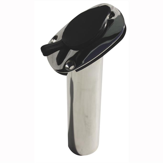
Viper Pro Series Deluxe Stainless Rod Holder – 30 degree (BM-10001)
Viper Pro Series Deluxe Stainless Rod Holder – 30o Angle (BM-10001)
Heavy duty cast stainless steel rod holder with bottom gimble to support rod. Flush fitting with pre-drilled fastening holes. Heavy duty construction, which are fully welded, and hand polished to a shiny finish. Strong enough for offshore and bay fishing. Complete with cap to prevent water ingress.
SKU: BM-10001 -
Lighting
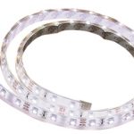
LED Exterior/Interior Strip Light 1m Cool White
LED Exterior/Interior Strip Light 1m Cool White
Super bright multi-purpose LED strip lights available in a range of colours in one and five metre lengths. Features 60 SMD 3528 LED’s per metre set within a clear, low profile, flexible outer casing to provide excellent protection against the elements. Waterproof and rated to IP67.
Each 12 volt strip is pre-wired and may be cut to individual requirements. Supplied with quality ‘3M’ brand self-adhesive tape, plastic mounting clips for added security and additional end caps.
Suitable for marine, outdoor, home, camping, caravan and RV for a wide range of applications. Supplied in bright retail clam packaging.
Features:
Pre-wired and may be cut to individual lengths
Uses quality SMD 3528 LED’s
Ideal for outdoor use, rated to IP67
Long life span with minimal maintenance
Supplied with ‘3M’ self-adhesive tape and mounting clipsBBB Code LED Colour Length metre LED’s per metre Volts LED SMD Type Current draw per metre mHa Lumen per metre BBB-PISL1M3528BLUE Blue 1 60 12 3528 400 180 BBB-PISL1M3528CW Cool White 1 60 12 3528 400 300 BBB-PISL1M3528RED Red 1 60 12 3528 400 180 BBB-PISL1M3528WW Warm White 1 60 12 3528 400 180 SKU: 1M STRIP LIGHT - COOL WHITE -
Uncategorised
Lowrance Hook-4 / Hook-4x / Elite 4 HDI/4x HDI/4 CHIRP/4x CHIRP Sun Cover (000-11307-001)
 Uncategorised
Lowrance Hook-4 / Hook-4x / Elite 4 HDI/4x HDI/4 CHIRP/4x CHIRP Sun Cover (000-11307-001)
Lowrance Hook-4 / Hook-4x / Elite 4 HDI/4x HDI/4 CHIRP/4x CHIRP Sun Cover (000-11307-001)
Suits only Lowrance Hook-4, Hook-4x, Elite 4 HDI & Elite 4 CHIRP Sounder/GPS Combos, and Lowrance Elite 4x HDI & Lowrance Elite 4x CHIRP Fishfinder/Sounders.
*Specifications from suppliers’ information.
SKU: 000-11307-001AU