Garmin
Showing 121–150 of 316 results
-
Garmin, Garmin Radars
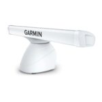
Garmin GMR™ 2526 xHD2 – 25kW 6′ Open Array Radar and Pedestal
Garmin GMR™ 2526 xHD2 – 25kW 6′ Open Array Radar and Pedestal – 1.8 METRE OPEN-ARRAY RADAR WITH 25 KW OF POWER
This incredibly powerful open-array radar is perfect for cruising and fishing offshore, overnight and in foggy, limited or no-visibility conditions.

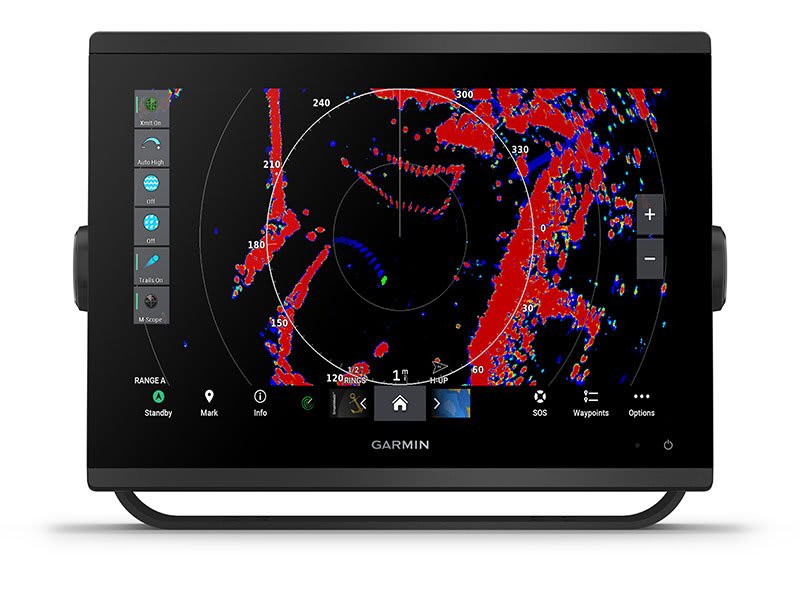
Serious seafarers like you need serious range — up to 96 nautical miles (177 km).

See targets in incredible detail, even at a distance.

Add even more detail to your maps with radar overlay — even in a split-screen view.

See flocks of birds on the water, and find baitfish below.

Maximise energy, and increase target size with pulse expansion.
SKU: K10-00012-16 -
Garmin, Garmin Radars
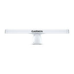
Garmin GMR™ 2534 xHD3 – 25kW 4′ Open Array Radar and Pedestal
Garmin GMR™ 2534 xHD3 – 25kW 4′ Open Array Radar and Pedestal – SCAN WITH THE MAGNETRON POWER OF GARMIN OPEN-ARRAY RADAR
Combining high-definition imaging with the latest Garmin platform technology, these robust 4’ open-array radars offer superior weather, obstacle and traffic detection for mariners cruising or fishing offshore.

25kW OUTPUT, UP TO 96-NAUTICAL MILE RANGE

SCAN AVERAGING TECHNOLOGY

IMPROVED TARGET-SIZE PROCESSING

SPLIT-SCREEN DUAL-RANGE DISPLAY

100-KNOT COMMERCIAL GRADE WIND RATING1

QUIET OPEN-ARRAY DRIVE MOTOR
SKU: K10-00012-28 -
Garmin, Garmin Radars
Garmin GMR™ 2536 xHD3 – 25kW 6′ Open Array Radar and Pedestal
Garmin GMR™ 2536 xHD3 – 25kW 6′ Open Array Radar and Pedestal – SCAN WITH THE MAGNETRON POWER OF GARMIN OPEN-ARRAY RADAR
Combining high-definition imaging with the latest Garmin platform technology, these robust 6’ open-array radars offer superior weather, obstacle and traffic detection for mariners cruising or fishing offshore.
25kW OUTPUT, UP TO 96-NAUTICAL MILE RANGE
SCAN AVERAGING TECHNOLOGY
IMPROVED TARGET-SIZE PROCESSING
SPLIT-SCREEN DUAL-RANGE DISPLAY
100-KNOT COMMERCIAL GRADE WIND RATING1
QUIET OPEN-ARRAY DRIVE MOTOR
SKU: K10-00012-29 -
Garmin, Garmin Radars
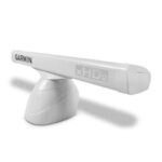
Garmin GMR™ 424 xHD2 – 4kW 4′ Open Array Radar and Pedestal
Garmin GMR™ 424 xHD2 – 4kW 4′ Open Array Radar and Pedestal – 1.2 METRE OPEN-ARRAY RADAR WITH 4 KW OF POWER
This high-definition open-array radar is perfect for cruising and fishing offshore, overnight and in foggy, limited or no-visibility conditions — especially on yachts and sport fishing boats under 12 metres.
Serious seafarers like you need serious range — up to 72 nautical miles (133 km).
See targets in incredible detail, even at a distance.
Easily see what’s close and far away with dual-range radar.

Don’t waste time fussing with complex settings. This radar is easy to install.

Say goodbye to noise pollution. This radar rotates quietly.
SKU: K10-00012-08 -
Garmin, Garmin Radars
Garmin GMR™ 434 xHD3 – 4kW 4′ Open Array Radar and Pedestal
Garmin GMR™ 434 xHD3 – 4kW 4′ Open Array Radar and Pedestal – SCAN WITH THE MAGNETRON POWER OF GARMIN OPEN-ARRAY RADAR
Combining high-definition imaging with the latest Garmin platform technology, these robust 4’ open-array radars offer superior weather, obstacle and traffic detection for mariners cruising or fishing offshore.
4kW OUTPUT, UP TO 96-NAUTICAL MILE RANGE
SCAN AVERAGING TECHNOLOGY
IMPROVED TARGET-SIZE PROCESSING
SPLIT-SCREEN DUAL-RANGE DISPLAY
100-KNOT COMMERCIAL GRADE WIND RATING1
QUIET OPEN-ARRAY DRIVE MOTOR
SKU: K10-00012-24 -
Garmin, Garmin Radars
Garmin GMR™ 436 xHD3 – 4kW 6′ Open Array Radar and Pedestal
Garmin GMR™ 436 xHD3 – 4kW 6′ Open Array Radar and Pedestal – SCAN WITH THE MAGNETRON POWER OF GARMIN OPEN-ARRAY RADAR
Combining high-definition imaging with the latest Garmin platform technology, these robust 6’ open-array radars offer superior weather, obstacle and traffic detection for mariners cruising or fishing offshore.
4kW OUTPUT, UP TO 96-NAUTICAL MILE RANGE
SCAN AVERAGING TECHNOLOGY
IMPROVED TARGET-SIZE PROCESSING
SPLIT-SCREEN DUAL-RANGE DISPLAY
100-KNOT COMMERCIAL GRADE WIND RATING1
QUIET OPEN-ARRAY DRIVE MOTOR
SKU: K10-00012-25 -
Garmin, Garmin Accessories, Sanctuary Cove
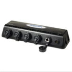
Garmin GMS 10 Network Port Expander
Garmin GMS 10 Network Port Expander
The GMS 10 Network Port Expander allows you to connect multiple chartplotters and sensors over the Garmin Marine Network. With this robust 100-megabit switch, you can connect multiple MFDs and sensors to the Garmin Marine Network and gain the benefit of Ethernet-like data transfer speeds up to 10 times faster than some competitive systems.
Just Plug and Play
The GMS 10 and the Garmin Marine Network are completely plug-and-play, which means that all peripherals are automatically detected and readily accessible once they’re connected to the network. Likewise, you can easily expand your system using the same standard data cable to plug additional units and displays into the GMS 10 network ports.
Waterproof Your Connections
The rugged GMS 10 is specifically designed to withstand the corrosive marine environment. All connections are totally waterproof, and sealed covers keep harmful moisture away from unused data ports.
GMS 10: Expand your network to its fullest potential
SKU: 010-00351-00 -
Garmin, Garmin Accessories
Garmin GNA 10 – NMEA 2000 Multi-Function Adapter For Reactor 40 Autopilots
 Garmin, Garmin Accessories
Garmin GNA 10 – NMEA 2000 Multi-Function Adapter For Reactor 40 Autopilots
Garmin GNA 10 – NMEA 2000 Multi-Function Adapter For Reactor 40 Autopilots
Use the Garmin GNA 10 to connect a jog lever to our Reactor 40 autopilots1 on displacement hull boats. A jog lever is a rugged and simple steering control for work boats or trawlers. Adjust heading hold with the jog lever by pressing it right or left, or put the autopilot into the new Power Steering mode to move the rudder without autopilot guidance. The GNA 10 can also optionally connect to a button and LED light to allow switching between heading hold and standby2. Garmin does not supply the jog lever, button or LED light.
Installation Instructions
SKU: 010-13007-00 -
Garmin, Garmin Accessories
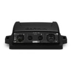
Garmin GND™ 10 Black Box Bridge
Garmin GND™ 10 Black Box Bridge
- Converts data between the Nexus network and NMEA 2000®
- Provides compatibility between Nexus and Garmin products
- Simple plug-and-play installation between Nexus, NMEA 2000 and USB
- No user setup or system configuration required
- Allows PC applications, such as NexusRace™, Expedition, Adrena or SeaTrack, to communicate sailing-specific functions between Nexus and NMEA 2000 networks
The GND 10 black box bridge seamlessly integrates Nexus instruments and sensors with the Garmin family. It converts data between the Nexus Network and NMEA 2000 to provide compatibility between Nexus and Garmin products, including gWind™ and gWind™ Race transducers. Simple plug-and-play installation between Nexus and NMEA 2000, with USB connectivity, eliminates the need for user setup and system configuration.
GND 10 allows PC applications, such as NexusRace, Expedition, Adrena or SeaTrack, to communicate sailing-specific functions between Nexus and NMEA 2000 networks. It also enables GND 10 software updates over NMEA 2000. Existing NexusRace PC application can be used to update software, configure and calibrate Nexus devices over USB using the FDX protocol.
SKU: 010-01226-00 -
Garmin, Garmin Accessories
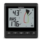
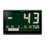
Garmin GNX Wind – 4-inch Wind Rose Display Marine Instrument
Garmin GNX Wind – 4-inch Wind Rose Display Marine Instrument – Affordable, Dedicated Wind Instrument
- Glass-bonded backlit monochrome LCD display lens avoids fogging
- Large, easy-to-read black digits on white or customizable background colors for high contrast and high visibility in all lighting conditions
- 2 data fields and a digital wind rose simultaneously display true and apparent wind data, Steer Pilot, boat speed and more
- Displays true and apparent wind speed and wind angles, true wind direction, boat speed, speed over ground, VMG, heading, course over ground and closed haul
- NMEA 2000® network and ANT technology interfaces
It’s Easy to See the Data You Need
If you own a 20- to 40-foot sailboat with no wind system or an older wind system onboard, then GNX Wind marine instrument is an excellent choice to provide the accurate, reliable data you need to make confident decisions.
GNX Wind features a high-visibility, glass-bonded backlit monochrome LCD display with customizable backlight colors making it easy to see from nearly any angle at a distance. Background colors can be customized to nearly any color preference to provide the contrast and visibility that work best in any lighting condition. It interfaces through the NMEA 2000 network to show 2 data fields and a digital wind rose simultaneously to display true and apparent wind data, Steer Pilot, boat speed and more. Auto-scroll feature rotates through screens for easy, hands-free operation. Low power consumption of 350 mW daylight (no backlight) and 400 mW nighttime (mid-level backlight) is perfect for sailboats. Customizable configurations include more than 15 important marine parameters for wind, speed and navigation. Installs easily, either flush or flat mount. It can even wirelessly connect to a compatible chartplotter or quatix® 3 GPS marine smartwatch to stream wind data directly to your wrist. Also available in a GNX Wired Sail Pack.
SKU: 010-01142-30 -
Garmin, Garmin Accessories
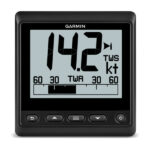
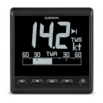
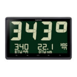
Garmin GNX™ 120 – 7-inch SInverted LCD Monochrome Display Marine Instrument
 Garmin, Garmin Accessories
Garmin GNX™ 120 – 7-inch SInverted LCD Monochrome Display Marine Instrument
Garmin GNX™ 120 – 7-inch SInverted LCD Monochrome Display Marine Instrument – Create a High-performance Glass Mast
- High-precision glass-bonded backlit LCD display avoids fogging
- Bold 2-inch (51 mm) digits are the largest digits in class
- Provides the data necessary to make confident decisions
- Displays more than 50 marine and boat parameters for wind, sea and vessel conditions
- Integrated sailing eco-system allows seamless sharing of sailing data between Garmin devices
 Designed for serious sailors who demand quality, precision and total integration, this high-precision glass-bonded 7-inch large format instrument creates a beautiful “glass mast” display with superior readability day and night. It allows seamless sharing of sailing data between Garmin devices and is controlled from a compatible GNX keypad. It is easy to set up, calibrate and use.
Superior Readability
Enjoy superior readability in all conditions, day and night¹. Options for white or color 2-inch (51 mm) digits — the largest in class — allow you to adjust for most preferred visibility setting for any lighting condition. The GNX 120 provides a flush mount glass mast look, and its glass-bonded high-contrast monochrome LCD display avoids fogging. Low power consumption of 0.36 W daylight with no backlight and 0.4 W nighttime with mid-level backlight preserves your batteries.
Customize Your Profile
Fully customizable user profiles allow you to configure the screen layout to your preferred setting. Five display configurations are available: single, dual and triple function, plus Gauge and Graph modes, to display data for more than 50 important marine parameters for wind, sea and vessel conditions. Display data from Expedition software on the instrument using a Actisence NGT-1 N2K USB or GND 10 (not required). Adrena and SmartSkipper information can also be displayed using the GND 10.
¹Color backlight is not visible in daylight.
SKU: 010-01395-00 -
Garmin, Garmin Accessories
Garmin GNX™ 130 – 10-inch SInverted LCD Monochrome Display Marine Instrument
 Garmin, Garmin Accessories
Garmin GNX™ 130 – 10-inch SInverted LCD Monochrome Display Marine Instrument
Garmin GNX™ 130 – 10-inch SInverted LCD Monochrome Display Marine Instrument – Easy-to-read With the Largest Digits in its Class
- High-precision glass-bonded backlit LCD display avoids fogging
- Bold 2.75-inch (70 mm) digits are the largest digits in class
- Provides the data necessary to make confident decisions
- Displays more than 50 marine and boat parameters for wind, sea and vessel conditions
- Integrated sailing eco-system allows seamless sharing of sailing data between Garmin devices
 Designed for serious sailors who demand quality, precision and total integration, this high-precision glass-bonded 10-inch large format instrument creates a beautiful “glass mast” display with superior readability day and night. It allows seamless sharing of sailing data between Garmin devices and is controlled from a compatible GNX keypad. It is easy to set up, calibrate and use.
Superior Readability
Enjoy superior readability in all conditions, day and night¹. Options for white or color 2.75-inch (70 mm) digits — the largest in class — allow you to adjust for most preferred visibility setting for any lighting condition. The GNX 130 provides a flush mount glass mast look, and its glass-bonded high-contrast monochrome LCD display avoids fogging. Low power consumption of 0.36 W daylight with no backlight and 0.4 W nighttime with mid-level backlight preserves your batteries.
Design Your Profile
Fully customizable user profiles allow you to configure the screen layout to your preferred setting. Five display configurations are available: single, dual and triple function, plus Gauge and Graph modes, to display data for more than 50 important marine parameters for wind, sea and vessel conditions. Display data from Expedition software on the instrument using a Actisence NGT-1 N2K USB or GND 10 (not required). Adrena and SmartSkipper information can also be displayed using the GND 10.
¹Color backlight is not visible in daylight.
SKU: 010-01396-00 -
Garmin, Garmin Accessories
Garmin GNX™ 20 – 4-inch Standard LCD Monochrome Display Marine Instrument
Garmin GNX™ 20- 4-inch Standard LCD Monochrome Display Marine Instrument
- Large, easy-to-read black digits and graphs on a white or color background provides high contrast and high visibility; choose from 7 customizable backlight colors¹
- Glass-bonded display with anti-glare lens avoids fogging
- Fully customizable user profiles for sail or power boating to display most important marine and vessel data
- Low power consumption (25 mA) with 350 mW (no backlight)/400 mW (mid-level backlight)
- 5 display configurations plus gauge and graph mode to display depth, speed, wind and 50+ marine and boat parameters
The easy-to-read GNX 20 marine instrument display with black digits on a white or color background clearly shows depth, speed, wind and 50-plus marine and boat parameters. Its glass-bonded display with anti-glare lens coating provides excellent daytime and nighttime readability with high-contrast digits scalable up to 36 mm.
The GNX 20 is the first glass-bonded marine instrument with a combination of directly driven LCD segments and a dot-matrix field to display graphical information. Its low power consumption — (25 mA) with 350 mW (no backlight)/400 mW (mid-level backlight) — is perfect for use on sailboats, and provides a valuable instrument for cruising and fishing. Fully customizable user profiles display wind, depth and speed data. Plus, the GNX 20 includes an auto-scroll feature that rotates through data screens for hands-free operation. It can be installed with the included low profile flush mount or an optional flat mount for the ultimate glass helm solution and custom look for your boat.
¹Color backlight is not visible in daylight.
SKU: 010-01142-00 -
Garmin, Garmin Accessories
Garmin GNX™ 21 – 4-inch Inverted LCD Monochrome Display Marine Instrument
Garmin GNX™ 21 – 4-inch Inverted LCD Monochrome Display Marine Instrument
- Large, easy-to-read white or color digits on a black background for high visibility in low-light or darkness; choose from 7 customizable backlight colors¹
- Glass-bonded display with anti-glare lens avoids fogging
- Fully customizable user profiles for sail or power boating to display most important marine and vessel data
- Low power consumption (25 mA) with 350 mW (no backlight)/400 mW (mid-level backlight)
- 5 display configurations plus gauge and graph mode to display depth, speed, wind and 50+ marine and boat parameters
The easy-to-read GNX 21 marine instrument has an inverted display with white or color digits on a black background that clearly shows depth, speed, wind and 50-plus marine and boat parameters. Its glass-bonded display with anti-glare lens coating provides excellent daytime and nighttime readability with high-contrast digits scalable up to 36 mm.
The GNX 21 is the first glass-bonded marine instrument with a combination of directly driven LCD segments and a dot-matrix field to display graphical information. Its low power consumption — (25 mA) with 350 mW (no backlight)/400 mW (mid-level backlight) — is perfect for use on sailboats, and provides a valuable instrument for cruising and fishing. Fully customizable user profiles display wind, depth and speed data. Plus, the GNX 21 includes an auto-scroll feature that rotates through data screens for hands-free operation. It can be installed with the included low profile flush mount or an optional flat mount for the ultimate glass helm solution and custom look for your boat.
¹Color backlight is not visible in daylight.
SKU: 010-01142-10 -
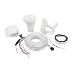
Garmin, Garmin Accessories, Sanctuary Cove
Garmin GPS 24xd HVS NMEA 0183
Garmin GPS 24xd HVS NMEA 0183 – EXPLORE COASTAL WATERS
The GPS 24xd position receiver and antenna gives you precise location with multi-band GNSS and heading accuracy even at slow speeds.

Navigate in more locations with expanded GNSS support.

Get high-sensitivity tracking with fast GPS update rate.

Accurately pinpoint your heading — regardless of speed.
It’s water-resistant (IPX7) to withstand the elements.

Install it easily with multiple mounting options.

The antenna is compatible with NMEA 2000® devices.
SKU: 010-02316-00 -
Garmin, Garmin Accessories, Sanctuary Cove
Garmin GPS 24xd NMEA 2000 – Black
Garmin GPS 24xd NMEA 2000 – EXPLORE COASTAL WATERS
The GPS 24xd position receiver and antenna gives you precise location with multi-band GNSS and heading accuracy even at slow speeds.
Navigate in more locations with expanded GNSS support.
Get high-sensitivity tracking with fast GPS update rate.
Accurately pinpoint your heading — regardless of speed.
It’s water-resistant (IPX7) to withstand the elements.
Install it easily with multiple mounting options.
The antenna is compatible with NMEA 2000® devices.

More accurate data — for more confident navigation.
MULTI-BAND GNSS
Multi-band GNSS provides precise location accuracy1 to within 1 metre to compatible marine multifunction displays, instrument displays and autopilots.
MAGNETIC HEADING
The magnetic heading sensor provides accuracy to within 3 degrees, stabilising charts, radar overlay and MARPA even at slow speeds.
HIGH-SENSITIVITY GPS
Fast 10 Hz position update rates provide high-sensitivity position, velocity and time data.
EXPANDED GNSS SUPPORT
GPS 24xd provides access to four key global navigation satellite systems (GPS, Galileo2, GLONASS and BeiDou2) to more accurately track in challenging conditions than GPS alone.
MULTI-SBAS COMPATIBLE
Multi-SBAS compatibility corrects signal measurement errors and provides information about the accuracy, integrity, continuity and availability of its signals.
MOUNTING OPTIONS
Installation is easy with under-deck, pole and surface-mount options.
11 < 1 metre CEP, < 3 metres 95%2Supported when available What’s in the box?
- GPS 24xd NMEA 2000®
- Pole mount
- Surface mount
- Under-deck mount
- NMEA 2000 backbone/drop cable (6 metres)
- NMEA 2000 T-connector
- Documentation
Installation Instructions
Setting Up A NMEA Network and Installing a Garmin GPS 24XD on a boat
SKU: 010-02316-20 -
Garmin, Garmin Accessories, Sanctuary Cove
Garmin GPS 24xd NMEA 2000 – White
Garmin GPS 24xd NMEA 2000 – EXPLORE COASTAL WATERS
The GPS 24xd position receiver and antenna gives you precise location with multi-band GNSS and heading accuracy even at slow speeds.
Navigate in more locations with expanded GNSS support.
Get high-sensitivity tracking with fast GPS update rate.
Accurately pinpoint your heading — regardless of speed.
It’s water-resistant (IPX7) to withstand the elements.
Install it easily with multiple mounting options.
The antenna is compatible with NMEA 2000® devices.
More accurate data — for more confident navigation.
MULTI-BAND GNSS
Multi-band GNSS provides precise location accuracy1 to within 1 metre to compatible marine multifunction displays, instrument displays and autopilots.
MAGNETIC HEADING
The magnetic heading sensor provides accuracy to within 3 degrees, stabilising charts, radar overlay and MARPA even at slow speeds.
HIGH-SENSITIVITY GPS
Fast 10 Hz position update rates provide high-sensitivity position, velocity and time data.
EXPANDED GNSS SUPPORT
GPS 24xd provides access to four key global navigation satellite systems (GPS, Galileo2, GLONASS and BeiDou2) to more accurately track in challenging conditions than GPS alone.
MULTI-SBAS COMPATIBLE
Multi-SBAS compatibility corrects signal measurement errors and provides information about the accuracy, integrity, continuity and availability of its signals.
MOUNTING OPTIONS
Installation is easy with under-deck, pole and surface-mount options.
11 < 1 metre CEP, < 3 metres 95%2Supported when available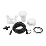 What’s in the box?
- GPS 24xd NMEA 2000®
- Pole mount
- Surface mount
- Under-deck mount
- NMEA 2000 backbone/drop cable (6 metres)
- NMEA 2000 T-connector
- Documentation
Installation Instructions
Setting Up A NMEA Network and Installing a Garmin GPS 24XD on a boat
SKU: 010-02316-10 -
Garmin, Garmin Chartplotters, Sanctuary Cove
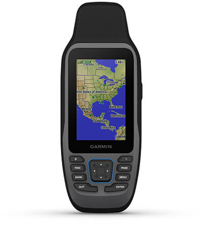
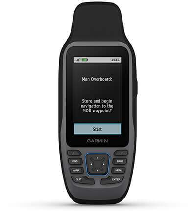
Garmin GPS 73
Garmin GPS 73 – Easy-to-use GPS Handheld Navigator
- High-sensitivity GPS marks and stores 1,000 waypoints and 100 tracks
- Marks your favorite locations to easily navigate back to them
- Garmin SailAssist™ for GPS 73 includes virtual starting line, heading line, countdown timers and tack assist
- Sunrise/sunset, estimated time of arrival, other calculations and marine data
- Built-in backlight
This easy-to-use handheld is the perfect navigational solution for boats, sailboats or small watercraft that do not have a chartplotter. It’s also ideal as an important emergency navigation backup for all vessels. Its high-sensitivity GPS marks and stores 1,000 waypoints and 100 tracks so you can navigate right back to them. Use on land or water — it floats! Features SailAssist, including virtual starting line, heading line, countdown timers and tack assist.
Quickly Acquires Satellites
High-sensitivity GPS receiver quickly locks onto GPS signals and tracks your location even in challenging locations, such as deep canyons or under heavy tree cover.
Mark Important Waypoints
Whether it’s a hot fishing spot or a lobster pot, you can mark and store 1,000 waypoints and 100 tracks to navigate to and from time and time again.
SailAssist
SailAssist helps you sail more effectively with heading line and tack assist. Tack assist lets you know when to tack based on whether your boat is getting headed or lifted compared to the boat’s optimal tacking angle. For those who like to race, there’s virtual starting line and countdown timer to make sure you cross the starting line at the right time.
Store Important Data
GPS 73 is NMEA 0183 compatible. To transfer data to your device, it easily connects to your computer via USB. If you’re into boating, hunting or fishing, you can use the built-in celestial data, which includes sunrise/sunset times and a hunting and fishing calendar, estimated time of arrival, other calculations and marine data.
High-contrast Display
GPS 73 has an intuitive user interface with dedicated back-lit buttons for quick and easy operation. Its high-contrast display makes it easy to read in all lighting conditions.
In the box
- GPS 73
- Lanyard
- Quick start manual
Owner’s Manual
SKU: 010-01504-00 -
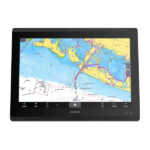
Garmin, Garmin Chartplotters, Sanctuary Cove
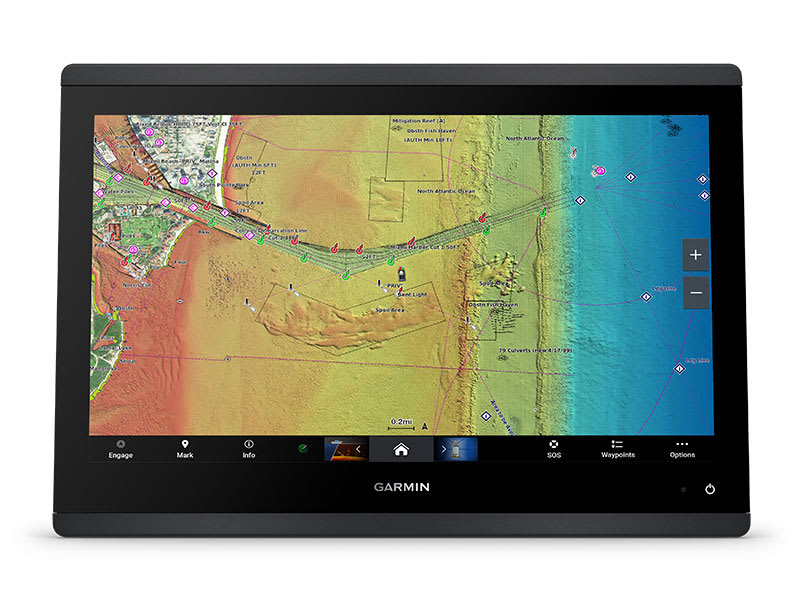
Garmin GPSMAP 1022xsv – Chartplotter without Transducer but with SideVü, ClearVü and Traditional CHIRP Sonar & Worldwide Basemap
-8% Garmin, Garmin Chartplotters, Sanctuary Cove
Garmin GPSMAP 1022xsv – Chartplotter without Transducer but with SideVü, ClearVü and Traditional CHIRP Sonar & Worldwide Basemap
Garmin GPSMAP 1022xsv Chartplotter – without Transducer, but with SideVü, ClearVü and Traditional CHIRP Sonar & Worldwide Basemap.
A PREMIUM CHARTPLOTTER FOR THE ADVENTUROUS SPIRIT
These chartplotters feature large, bright screens coupled with quick and easy-to-use keypad interfaces with user-programmable keys and multifunction control knobs to help you navigate with ease.

Get wider viewing angles on a vivid 10″ or 12″ colour display.

These are compatible with our premium maps and charts for the best in Garmin navigation.

Share information among multiple units, thanks to Garmin Marine Network support.

See fluid position and heading changes with update rates of 10 times per second.

Easily transfer waypoints, tracks and routes from your other GPS devices.

See what’s around your boat with built-in sonar capabilities on select models (transducers sold separately).
SKU: 010-01740-02 -
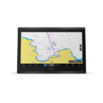
Garmin, Garmin Chartplotters, Sanctuary Cove
Garmin GPSMAP 1222xsv – Chartplotter without Transducer but with SideVü, ClearVü and Traditional CHIRP Sonar & Worldwide Basemap
-9% Garmin, Garmin Chartplotters, Sanctuary Cove
Garmin GPSMAP 1222xsv – Chartplotter without Transducer but with SideVü, ClearVü and Traditional CHIRP Sonar & Worldwide Basemap
Garmin GPSMAP 1222xsv Chartplotter – without Transducer, but with SideVü, ClearVü and Traditional CHIRP Sonar & Worldwide Basemap.
A PREMIUM CHARTPLOTTER FOR THE ADVENTUROUS SPIRIT
These chartplotters feature large, bright screens coupled with quick and easy-to-use keypad interfaces with user-programmable keys and multifunction control knobs to help you navigate with ease.
Get wider viewing angles on a vivid 10″ or 12″ colour display.
These are compatible with our premium maps and charts for the best in Garmin navigation.
Share information among multiple units, thanks to Garmin Marine Network support.
See fluid position and heading changes with update rates of 10 times per second.
Easily transfer waypoints, tracks and routes from your other GPS devices.
See what’s around your boat with built-in sonar capabilities on select models (transducers sold separately).
SKU: 010-01741-02 -
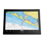
EOFY, Garmin, Garmin Chartplotters, Marine Electronics, Sanctuary Cove, Sounders
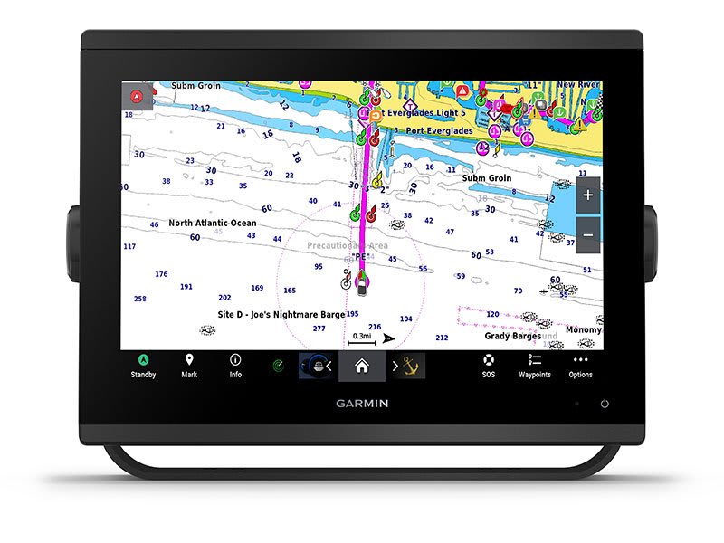
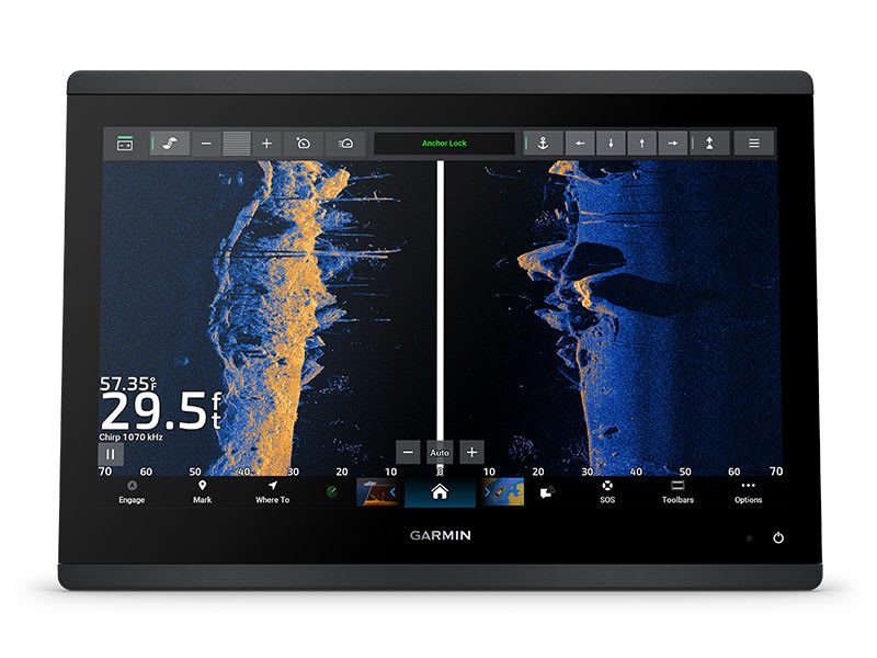
Garmin GPSMAP 1253xsv
-10% EOFY, Garmin, Garmin Chartplotters, Marine Electronics, Sanctuary Cove, Sounders
Garmin GPSMAP 1253xsv
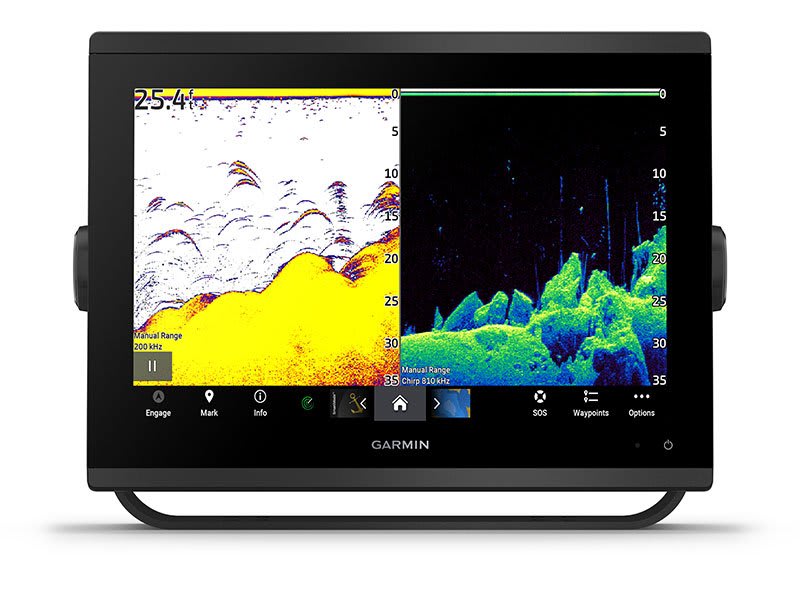
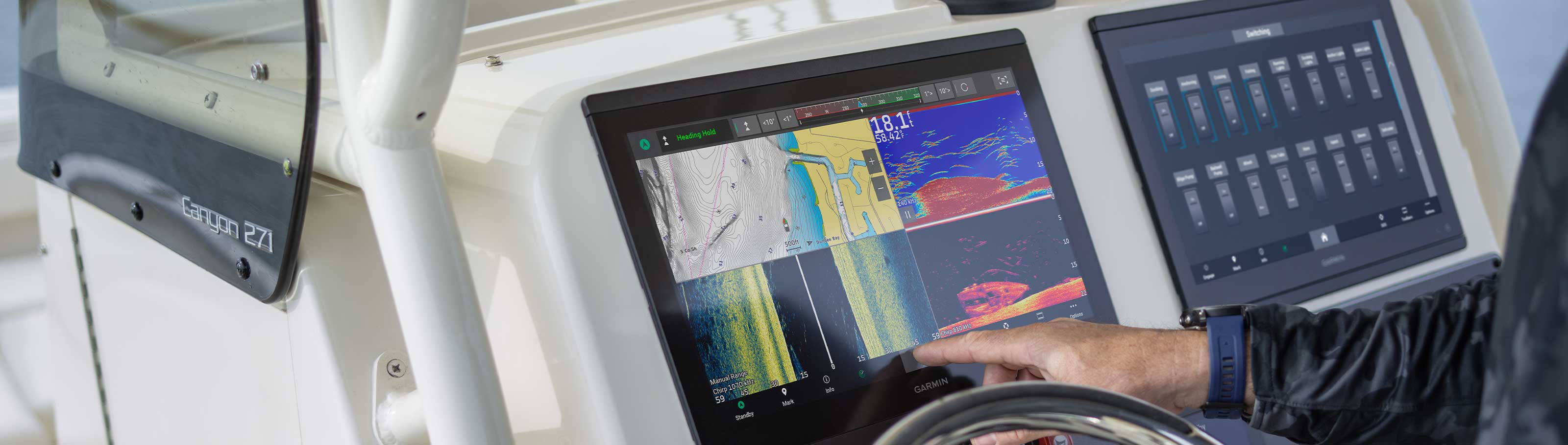
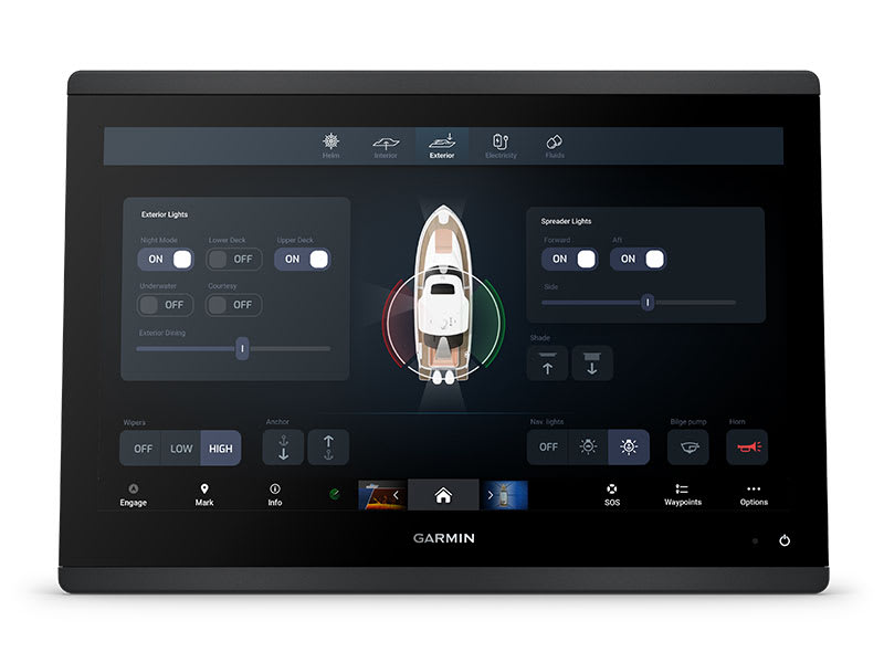
Garmin GPSMAP 1253xsv – GET A SHARPER VIEW FROM YOUR CONNECTED HELM
With its sleek design, powerful processing and upgraded IPS display, this advanced 12″ chartplotter integrates seamlessly into your Garmin marine system.
Easily integrate with more engines. Connect to compatible third-party devices with OneHelm™ digital switching.
 Easily build your marine system using the best of network connectivity.
 Compatible with premium maps and charts1 for the best in Garmin navigation.
 See below your boat with built-in sonar capabilities
 Manage your marine experience from nearly anywhere1.
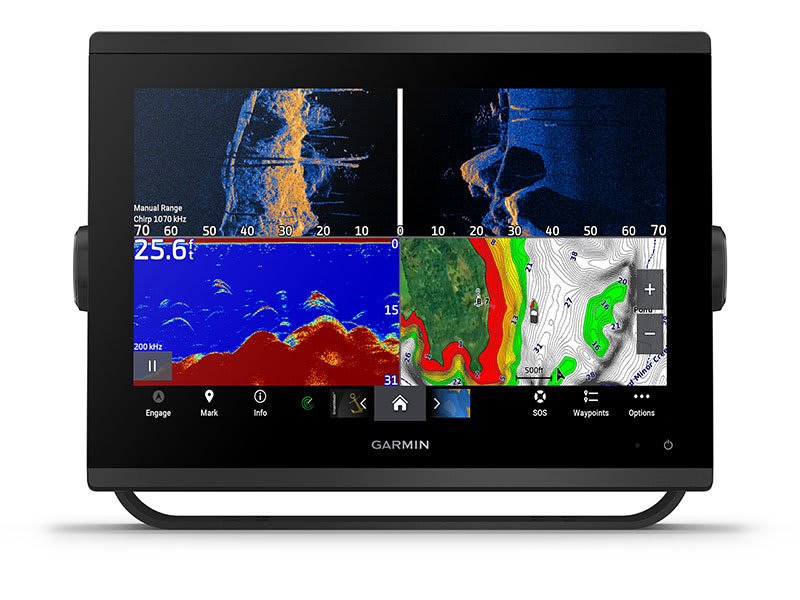
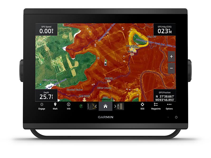
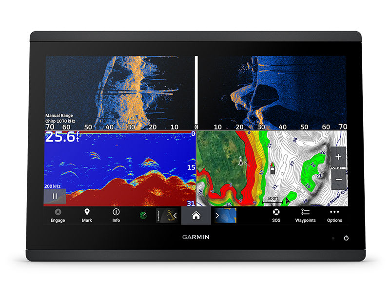
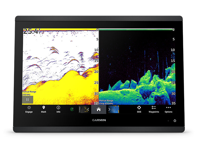
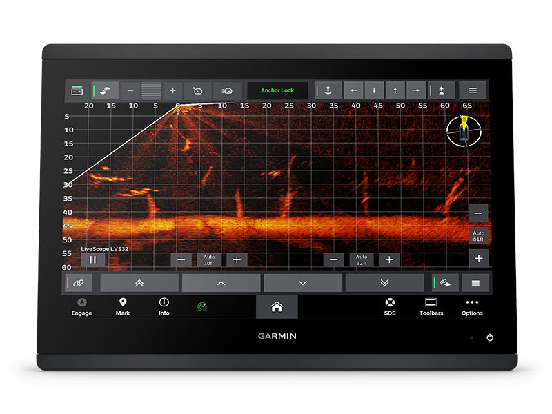
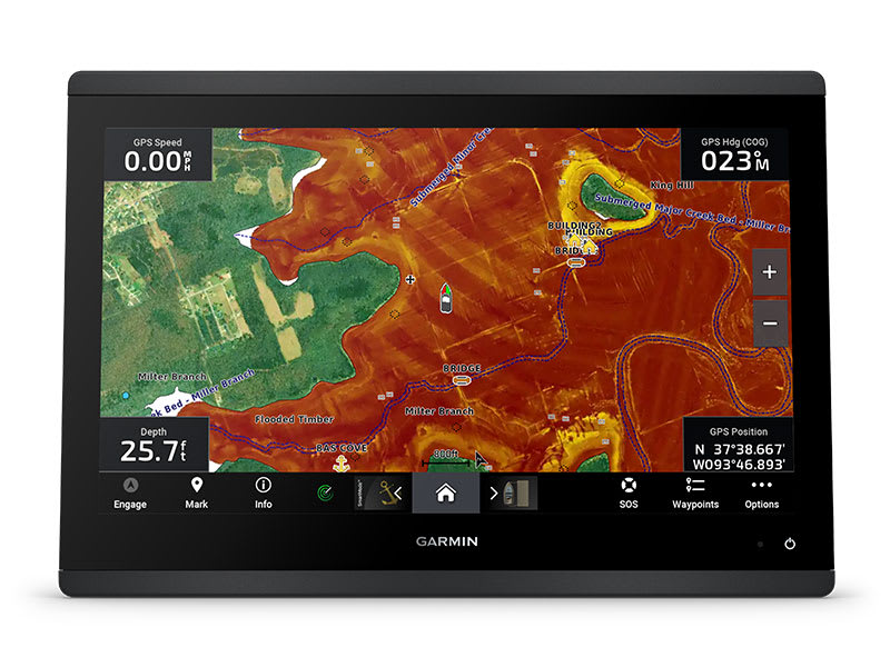
See the world below.
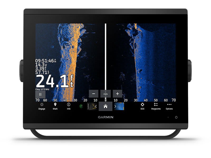
ULTRA HIGH-DEFINITION SCANNING SONAR
Get built-in Ultra High-Definition SideVü and ClearVü scanning sonars with vivid, high-contrast color palettes to help distinguish fish from structure. GPSMAP® X3 series also supports 1 kW CHIRP traditional sonar capabilities. Built-in sonar compatibility only available on xsv models.
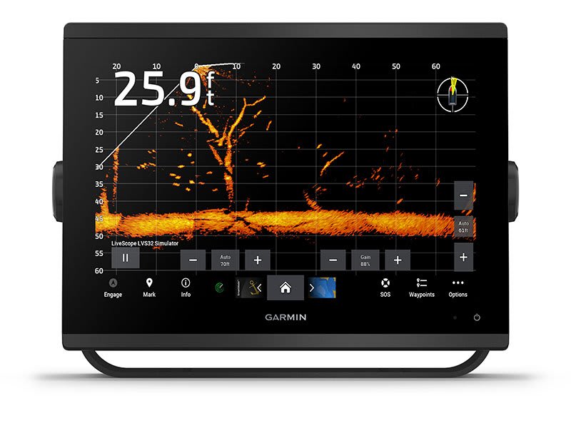
PANOPTIX™ & LIVESCOPE™ SONAR SUPPORT
Pair with Panoptix or LiveScope™ easy-to-interpret live sonar (transducer required, sold separately) to see all around your boat in real time.
Made for your helm.
FASTER, SHARPER, SMARTER
With its added processing power and new slimline design featuring edge-to-edge glass and a smaller unit footprint, it’s easy to retrofit this plotter in a wider range of dash configurations.
IMPROVED DISPLAY OPTICS
New higher-resolution IPS displays for 9″ and 12″ plotters offer improved sunlight readability and visibility from any angle, with 50% more pixels than previous-generation 9″ GPSMAP devices.
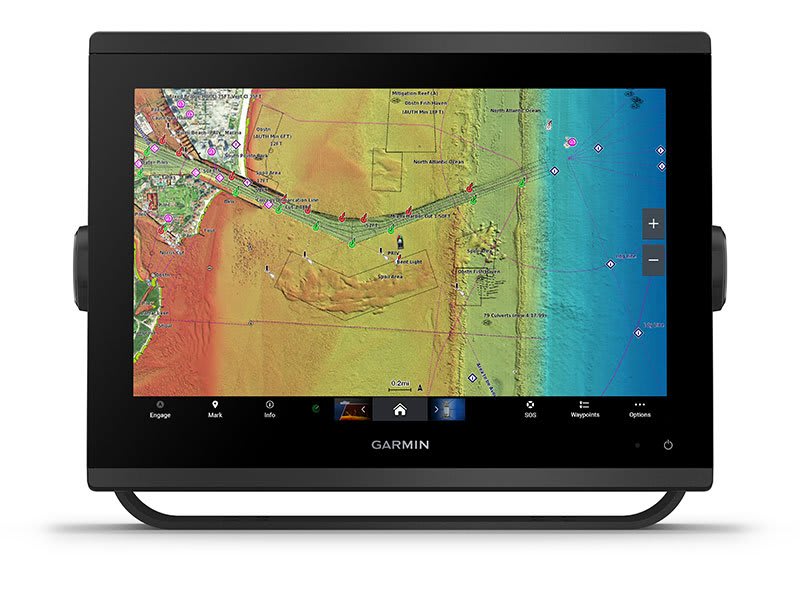
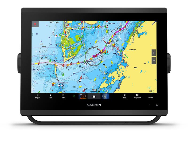
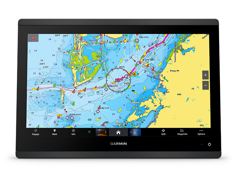
CHARTS AND MAPS
Bring a fresh new look and feel to your chartplotter with optional Garmin Navionics+™ or premium Garmin Navionics Vision+™ cartography featuring integrated coastal/inland content, access to daily updates, Auto Guidance+™ technology3 and more.
OPTIONAL RADAR BUNDLE
To help you avoid weather and traffic on the water, the compact 4 kW GMR™ 18 HD+ dome radar is available as a bundled option with your GPSMAP chartplotter/sonar package.

Sail and navigate with ease.
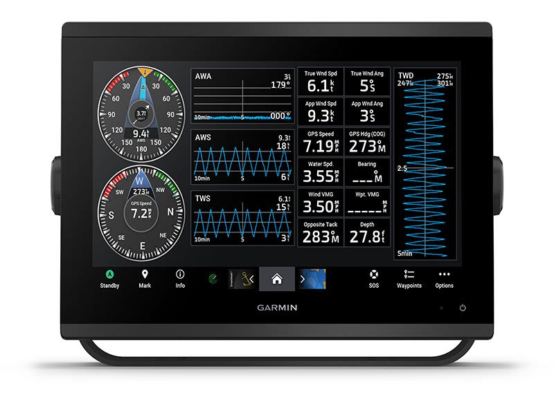
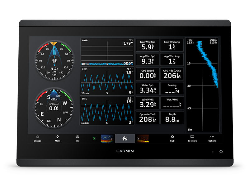
GARMIN SAILASSIST™ SAILING FEATURES
View laylines, race start line guidance, enhanced wind rose, heading and course-over-ground lines, true wind data fields and tide/current/time slider, wind angle, set and drift, wind speed and more.
OPTIONAL PREMIUM NAVIGATION FEATURES
These optional charts offer the best of Garmin and Navionics® data, Auto Guidance3 technology and other premium navigation features.
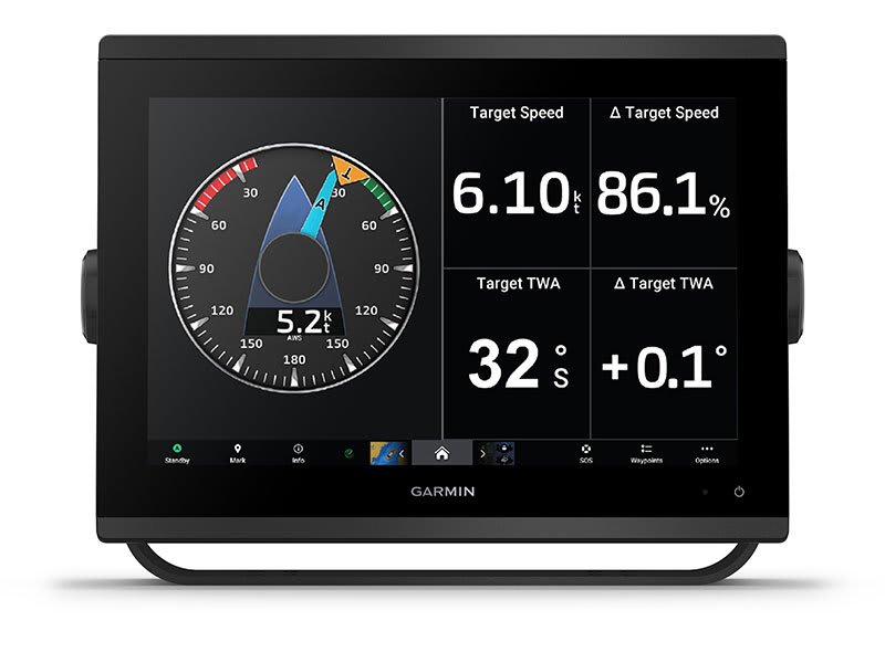
SAILING POLARS
Use the polar table to see key data, including how fast you should go at a certain wind angle and speed — so you know whether you need to adjust sail trim.
GARMIN MARINE NETWORK
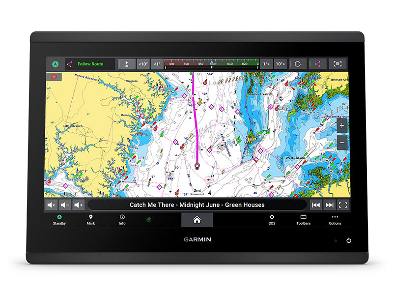
If you have multiple compatible Garmin devices on your boat, you can share information — such as maps, user data, radar and IP camera video — among them.
NMEA 2000® AND NMEA 0183 NETWORKS
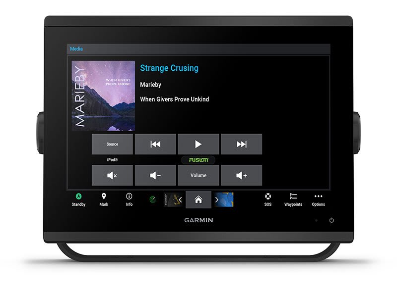
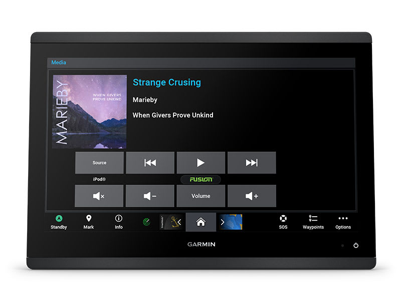
Connect to compatible autopilots, digital switching, weather, Fusion-Link™ audio system, media, VHF, AIS and more from one screen.
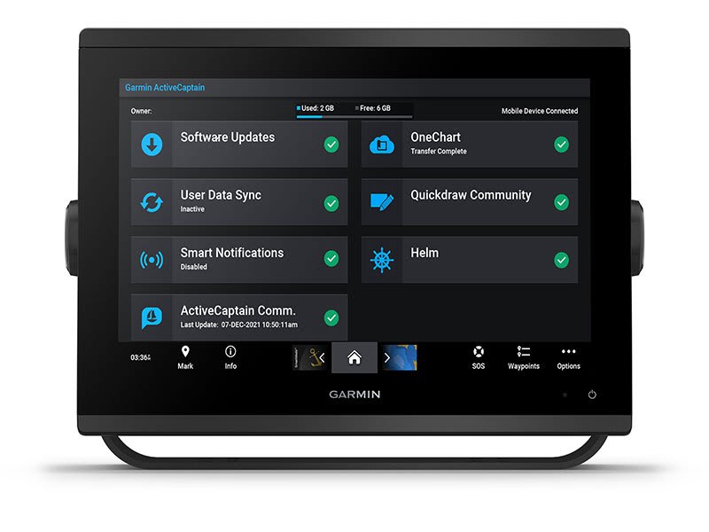
ACTIVECAPTAIN® APP
Built-in Wi-Fi® connectivity pairs with the free all-in-one mobile app for access to the OneChart™ feature, smart notifications, software updates, Garmin Helm™ digital switching, Garmin Quickdraw™ Community 4.
INTEGRATED ANT® TECHNOLOGY
Connect with some of your favourite devices, such as quatix® marine watches, gWind™ Wireless 2 transducers, GNX™ Wind marine instruments and wireless remote controls.
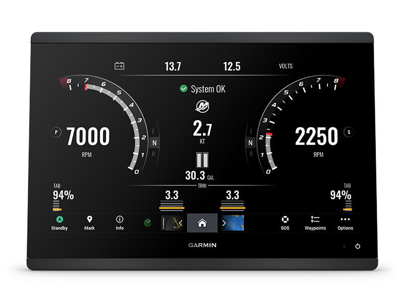
ENGINE CONNECTIVITY
Now you can connect your chartplotter to different kinds of engines, including select Yamaha engines.
ONEHELM FEATURE
This feature brings together all the operations and capabilities of select third-party devices, such as EmpirBus™ digital switching, on one screen.
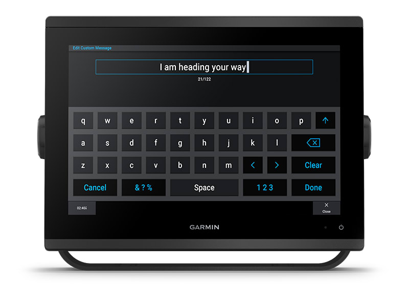
SEND INREACH® DEVICE MESSAGES
Pair your inReach satellite communicator5 to your chartplotter, and type custom messages using your MFD’s on-screen keyboard. Access your contact list or enter an email, inReach address or phone number. You can also group messages by conversation for a texting-like experience.
What’s in the box?
- GPSMAP 1253xsv chartplotter
- microSD™ card preinstalled
- Power cable
- NMEA 2000® T-connector
- NMEA 2000 drop cable (2 meters)
- 8-pin transducer to 12-pin sounder adapter cable
- Bail mount kit with knobs
- Flush mount kit with gasket
- Protective cover
- Trim piece snap covers
- Documentation
View Installation Instructions
View Owner’s Manual
SKU: 010-02367-62 -
EOFY, Garmin, Garmin Chartplotters, Marine Electronics, Sanctuary Cove, Sounders
Garmin GPSMAP 1653xsv – SideVu, ClearVu and Traditional CHIRP Sonar with Mapping
-6% EOFY, Garmin, Garmin Chartplotters, Marine Electronics, Sanctuary Cove, Sounders
Garmin GPSMAP 1653xsv – SideVu, ClearVu and Traditional CHIRP Sonar with Mapping
Garmin GPSMAP 1653xsv – GET A SHARPER VIEW FROM YOUR CONNECTED HELM
With its sleek design, powerful processing and upgraded IPS display, this advanced 16″ chartplotter integrates seamlessly into your Garmin marine system.
 Easily integrate with more engines.
 Easily build your marine system by using our advanced network connectivity. Navigate any waters with preloaded Garmin Navionics+™ charts on select models. See below your boat with built-in sonar capabilities (only available on xsv models.)
 Manage your marine experience from nearly anywhere1.
See the world below.
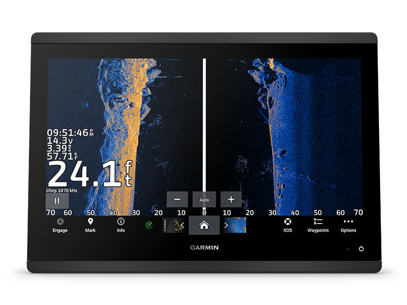
ULTRA HIGH-DEFINITION SCANNING SONAR
Get built-in Ultra High-Definition SideVü™ and ClearVü™ scanning sonars with vivid, high-contrast colour palettes to help distinguish fish from structure. The GPSMAP X3 chartplotter series also supports 1 kW traditional sonar capabilities.Built-in sonar compatibility only available on xsv models.
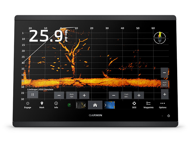
PANOPTIX™ SONAR SUPPORT
Pair with Panoptix™ or LiveScope™ easy-to-interpret live sonar (transducer required, sold separately) to see all around your boat in real time.
Made for your helm.
FASTER, SHARPER, SMARTER
With its added processing power and slimline design featuring edge-to-edge glass, it’s easy to fit this plotter in a wider range of dash configurations.
BRIGHT AND CLEAR OPTICS
High-resolution IPS displays for 16″ chartplotters offer improved sunlight readability and visibility from any angle.
PRELOADED MAPPING
Experience unparalleled coverage and detail with built-in Garmin Navionics+™ integrated coastal and inland mapping that includes Auto Guidance+™ technology2 and a 1-year subscription for downloadable daily updates and more on select chartplotters.
OPTIONAL CHARTS AND MAPS
Bring a fresh new look and feel to your chartplotter with an optional upgrade to a Garmin Navionics Vision+™ premium chart subscription, featuring downloadable relief shading, satellite imagery,
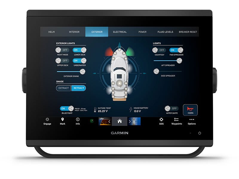
POWER-POLE® SHALLOW WATER ANCHOR
By networking select Garmin chartplotters with a Force® trolling motor and your compatible Power-Pole shallow water anchoring system, you can access advanced boat control features3 from your plotter, including smart anchor auto-deployment, smart anchor jog, auto stow, anchor drag detection and auto guidance2 end-of-route anchoring. Spend more time fishing, less time positioning.
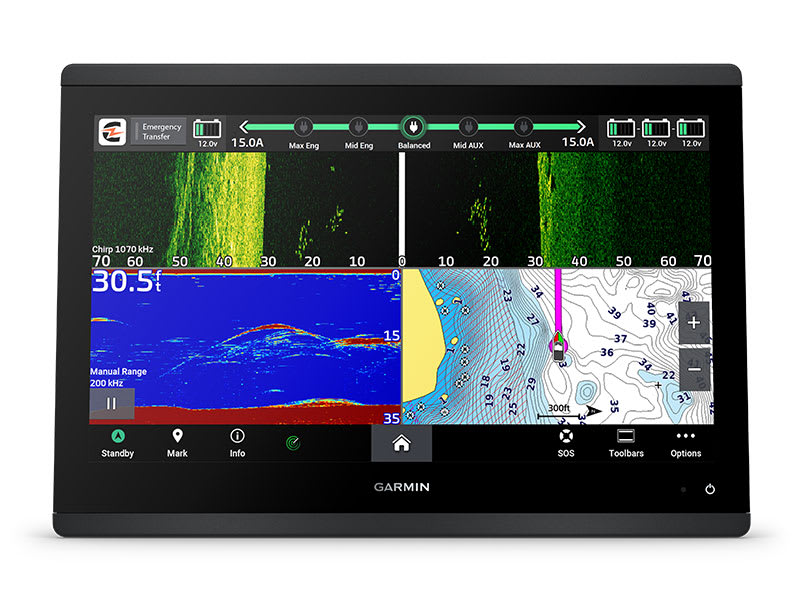
CHARGE INTEGRATION FROM POWER-POLE
Your CHARGE Marine Power Manager from Power-Pole integrates with compatible Garmin chartplotters to help keep your battery power going longer and stronger on the water. You’re able to charge batteries on the run, monitor power use, select where power is allocated, control emergency starts and even transfer power between battery banks — all from your chartplotter display.
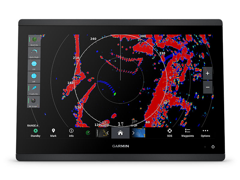
OPTIONAL RADAR BUNDLE
To help you avoid weather and traffic on the water, the compact 4 kW GMR™ 18 HD3 dome radar is available as a bundled option with select GPSMAP chartplotter/sonar packages.
TROLLING MOTOR INTEGRATION
Get support and integration for your Force trolling motor (sold separately) to gain complete control while you fish.

Sail and navigate with ease.
GARMIN SAILASSIST™ SAILING FEATURES
View laylines, race start line guidance, enhanced wind rose, heading and course-over-ground lines, true wind data fields and tide/current/time slider, wind angle, set and drift, wind speed and more.
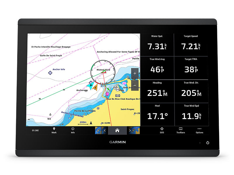
SAILING POLARS
Use the polar table to see key data, including how fast you should go at a certain wind angle and speed — so you know whether you need to adjust sail trim.
GARMIN MARINE NETWORK
If you have multiple compatible Garmin devices on your boat, you can share information — such as maps, user data, radar and IP camera video — among them.
NMEA 2000® AND NMEA 0183 NETWORKS
Connect to compatible autopilots, digital switching, weather, the Fusion audio system, media, VHF, AIS and more from one screen.
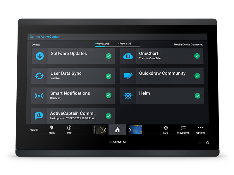
ACTIVECAPTAIN® APP
Built-in Wi-Fi® connectivity pairs with the free all-in-one mobile app for access to the OneChart™ feature, smart notifications, software updates, Helm app, Garmin Quickdraw™ Community data and more1.
INTEGRATED ANT® TECHNOLOGY
Connect with some of your favorite devices, such as quatix® marine watches, gWind™ Wireless 2 transducers GNX™ Wind marine instruments and wireless remote controls.
ENGINE CONNECTIVITY
You can connect your chartplotter to different engines, including select Yamaha® engines.
ONEHELM FEATURE
This feature brings together all the operations and capabilities of select third-party devices, such as EmpirBus™ digital switching, on one screen.
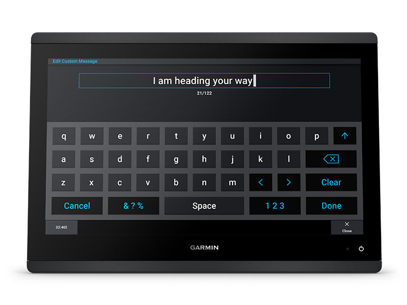
SEND INREACH® DEVICE MESSAGES
Pair your inReach satellite communicator4 to your chartplotter, and type custom messages using your MFD’s on-screen keyboard. Access your contact list or enter an email, inReach address or phone number. You can also group messages by conversation for a texting-like experience.
What’s in the box?
- GPSMAP® 1653xsv Chartplotter
- microSD™ card preinstalled
- 8-pin transducer to 12-pin sounder adapter cable
- Power cable
- Flush mount kit with gasket
- Protective cover
- Trim piece snap covers
- Backbone/drop cable (2 metres) and T-connector for the NMEA 2000® network
- Documentation
View Installation Instructions
View Owner’s Manual
SKU: 010-02919-04 -
Garmin, Garmin Chartplotters, Sanctuary Cove
Garmin GPSMAP 753xsv – Chartplotter with SideVü, ClearVü and Traditional CHIRP Sonar with Garmin Navionics+ Mapping
-10% Garmin, Garmin Chartplotters, Sanctuary Cove
Garmin GPSMAP 753xsv – Chartplotter with SideVü, ClearVü and Traditional CHIRP Sonar with Garmin Navionics+ Mapping
Garmin GPSMAP 753xsv – GET A SHARPER VIEW FROM YOUR CONNECTED HELM
With its sleek design, powerful processing and upgraded IPS display, this advanced 7″ chartplotter integrates seamlessly into your Garmin marine system.
Easily integrate with more engines.
Connect to compatible third-party devices with OneHelm™ digital switching.
Easily build your marine system using the best network connectivity.
Compatible with premium maps and charts1 for the best in Garmin navigation.
See below your boat with built-in sonar capabilities
Manage your marine experience from nearly anywhere1.
SKU: 010-02365-62 -
Garmin, Garmin Chartplotters, Sanctuary Cove
Garmin GPSMAP 79s – Marine Handheld with Worldwide Basemap
-10% Garmin, Garmin Chartplotters, Sanctuary Cove
Garmin GPSMAP 79s – Marine Handheld with Worldwide Basemap
Garmin GPSMAP 79s – CAST OFF CONFIDENTLY
Stay on course, and track more adventures with these rugged, floating handhelds.
 It’s water-resistant, it floats, and it’s fogproof, so it belongs on the water — just like you.
 This thing can remember up to 10,000 waypoints and more, so you don’t have to.
 It’s nice to have reliable positioning when you’re out on the water.
 The built-in compass will point you in the right direction.
 Get the best of Garmin and Navionics® data with optional BlueChart® g3 coastal charts.
 Stay out longer with up to 19 hours of battery life in GPS mode.
Built for life on the boat.
RUGGED HANDHELD
This handheld is water-resistant IPX7 with a high-resolution colour display you can read in the sun. The glass is even scratch-resistant and fogproof.
DESIGNED TO FLOAT
If rough waters come and the handheld goes overboard, don’t worry. This device floats.

BATTERY LIFE
User-replaceable AA batteries (not included) provide up to 19 hours of battery life in GPS tracking mode.
Exactly what you need to navigate.
ACCURATE TRACKING
With support for multiple satellite constellations — such as GPS, GLONASS, Galileo, QZSS and SBAS — you’ll get accurate, reliable tracking and positioning around the world.
INCREASED MEMORY
More memory than previous models means you can save and track 10,000 waypoints, 250 routes and 300 fitness activity files.
BUILT-IN COMPASS
The 3-axis tilt-compensated electronic compass shows your heading — even while the boat is standing still.

BLUECHART COVERAGE
Preloaded BlueChart g3 coastal charts (GPSMAP 79sc only) give you leading-edge coverage, clarity and detail with integrated Garmin and Navionics data.
What’s in the box
- GPSMAP 79s
- Lanyard
- USB cable
- Documentation
View Owner’s Manual
Garmin® Training Video – Cast off confidently with the GPSMAP® 79 series
SKU: 010-02635-00 -
Garmin, Garmin Chartplotters, Sanctuary Cove
Garmin GPSMAP 79sc – Marine Handheld Preloaded with BlueChart g3 Coastal Charts
-10%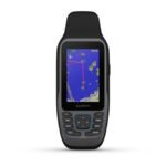 Garmin, Garmin Chartplotters, Sanctuary Cove
Garmin GPSMAP 79sc – Marine Handheld Preloaded with BlueChart g3 Coastal Charts
Garmin GPSMAP 79sc – Marine Handheld Preloaded with BlueChart g3 Coastal Charts – CAST OFF CONFIDENTLY
Stay on course, and track more adventures with these rugged, floating handhelds.
It’s water-resistant, it floats, and it’s fogproof, so it belongs on the water — just like you.
This thing can remember up to 10,000 waypoints and more, so you don’t have to.
It’s nice to have reliable positioning when you’re out on the water.
The built-in compass will point you in the right direction.
Get the best of Garmin and Navionics® data with optional BlueChart® g3 coastal charts.
Stay out longer with up to 19 hours of battery life in GPS mode.
Built for life on the boat.
RUGGED HANDHELD
This handheld is water-resistant IPX7 with a high-resolution colour display you can read in the sun. The glass is even scratch-resistant and fogproof.
DESIGNED TO FLOAT
If rough waters come and the handheld goes overboard, don’t worry. This device floats.
BATTERY LIFE
User-replaceable AA batteries (not included) provide up to 19 hours of battery life in GPS tracking mode.
Exactly what you need to navigate.
ACCURATE TRACKING
With support for multiple satellite constellations — such as GPS, GLONASS, Galileo, QZSS and SBAS — you’ll get accurate, reliable tracking and positioning around the world.
INCREASED MEMORY
More memory than previous models means you can save and track 10,000 waypoints, 250 routes and 300 fitness activity files.
BUILT-IN COMPASS
The 3-axis tilt-compensated electronic compass shows your heading — even while the boat is standing still.
BLUECHART COVERAGE
Preloaded BlueChart g3 coastal charts (GPSMAP 79sc only) give you leading-edge coverage, clarity and detail with integrated Garmin and Navionics data.
What’s in the box
- GPSMAP 79s or 79sc, depending on the version selected
- Lanyard
- USB cable
- Documentation
View Owner’s Manual
Garmin® Training Video – Cast off confidently with the GPSMAP® 79 series
SKU: 010-02635-03 -
EOFY, Garmin, Garmin Chartplotters, Sanctuary Cove
Garmin GPSMAP 8412xsv – Chartplotter With Worldwide Basemap & Sonar
-10%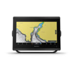 EOFY, Garmin, Garmin Chartplotters, Sanctuary Cove
Garmin GPSMAP 8412xsv – Chartplotter With Worldwide Basemap & Sonar
Garmin GPSMAP 8412xsv – With Worldwide Basemap & Sonar – SERIOUS ANGLERS, CRUISERS, SAILORS AND SAIL RACERS DEMAND SERIOUS EQUIPMENT
The easy-to-use, easy-to-install chartplotter/sonar combo delivers MFD performance in a combo-size package.

Get wider viewing angles and superior clarity on the touchscreen with a full HD in-plane switching (IPS) display.
It’s compatible with premium maps and charts for the best in Garmin navigation.
Easily build your marine system using the best of network connectivity.

See below and around your boat with built-in sonar capabilities (transducers sold separately)

From ANT® technology to Wi-Fi® networking, there are countless ways to connect to your system.

With SmartMode™ station controls, everything is designed to give you quick, one-touch access to the information you need.
SKU: 010-02092-02 -
EOFY, Garmin, Garmin Chartplotters, Sanctuary Cove
Garmin GPSMAP 8416xsv – Chartplotter With Worldwide Basemap & Sonar
-10%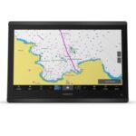 EOFY, Garmin, Garmin Chartplotters, Sanctuary Cove
Garmin GPSMAP 8416xsv – Chartplotter With Worldwide Basemap & Sonar
Garmin GPSMAP 8416xsv – Chartplotter With Worldwide Basemap & Sonar – SERIOUS ANGLERS, CRUISERS, SAILORS AND SAIL RACERS DEMAND SERIOUS EQUIPMENT
The easy-to-use, easy-to-install chartplotter/sonar combo delivers MFD performance in a combo-size package.
Get wider viewing angles and superior clarity on the touchscreen with a full HD in-plane switching (IPS) display.
It’s compatible with premium maps and charts for the best in Garmin navigation.
Easily build your marine system using the best of network connectivity.
See below and around your boat with built-in sonar capabilities (transducers sold separately)
From ANT® technology to Wi-Fi® networking, there are countless ways to connect to your system.
With SmartMode™ station controls, everything is designed to give you quick, one-touch access to the information you need.
SKU: 010-02093-02 -
Garmin, Garmin Chartplotters
Garmin GPSMAP 8417 MFD- Chartplotter With Worldwide Basemap
Garmin GPSMAP 8417 MFD- Chartplotter With Worldwide Basemap – TAKE CONTROL OF A BEAUTIFUL HELM
The large-format MFD lets you experience a beautifully powerful, completely networked helm at your fingertips.
Premium full HD touchscreen features Garmin’s highest resolution display.
It’s compatible with premium maps and charts for the best in Garmin navigation.
Easily build your marine system using the best of network connectivity.
From ANT® technology to Wi-Fi® networking, there are countless ways to connect to your system.
Take the guesswork out of sailing with clear laylines and more right on the screen.
With SmartMode™ station controls, everything is designed to give you quick, one-touch access to the information you need.
SKU: 010-01510-00 -
Garmin, Garmin Chartplotters
Garmin GPSMAP 8422 MFD – Chartplotter With Worldwide Basemap
Garmin GPSMAP 8422 MFD- Chartplotter With Worldwide Basemap – TAKE CONTROL OF A BEAUTIFUL HELM
The large-format MFD lets you experience a beautifully powerful, completely networked helm at your fingertips.
Premium full HD touchscreen features Garmin’s highest resolution display.
It’s compatible with premium maps and charts for the best in Garmin navigation.
Easily build your marine system using the best of network connectivity.
From ANT® technology to Wi-Fi® networking, there are countless ways to connect to your system.
Take the guesswork out of sailing with clear laylines and more right on the screen.
With SmartMode™ station controls, everything is designed to give you quick, one-touch access to the information you need.
SKU: 010-01511-00 -
Garmin, Garmin Chartplotters
Garmin GPSMAP 8424 MFD – Chartplotter With Worldwide Basemap
Garmin GPSMAP 8424 MFD – Chartplotter With Worldwide Basemap – TAKE CONTROL OF A BEAUTIFUL HELM
The large-format MFD lets you experience a beautifully powerful, completely networked helm at your fingertips.
Premium full HD touchscreen features Garmin’s highest resolution display.
It’s compatible with premium maps and charts for the best in Garmin navigation.
Easily build your marine system using the best of network connectivity.
From ANT® technology to Wi-Fi® networking, there are countless ways to connect to your system.
Take the guesswork out of sailing with clear laylines and more right on the screen.
With SmartMode™ station controls, everything is designed to give you quick, one-touch access to the information you need.
SKU: 010-01512-00