
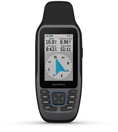
Garmin GPSMAP 79sc – Marine Handheld Preloaded with BlueChart g3 Coastal Charts
Price Match
$557.00 $619.00
Garmin GPSMAP 79sc – Marine Handheld Preloaded with BlueChart g3 Coastal Charts – CAST OFF CONFIDENTLY
Stay on course, and track more adventures with these rugged, floating handhelds.
![]()
It’s water-resistant, it floats, and it’s fogproof, so it belongs on the water — just like you.
![]()
This thing can remember up to 10,000 waypoints and more, so you don’t have to.
![]()
It’s nice to have reliable positioning when you’re out on the water.
![]()
The built-in compass will point you in the right direction.
![]()
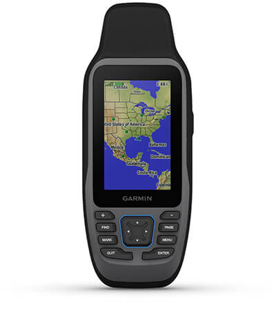
Get the best of Garmin and Navionics® data with optional BlueChart® g3 coastal charts.
![]()
Stay out longer with up to 19 hours of battery life in GPS mode.

Built for life on the boat.
RUGGED HANDHELD
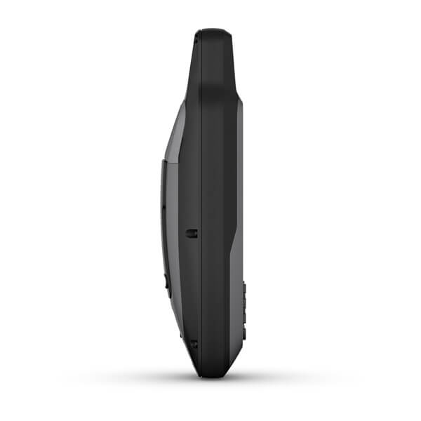
This handheld is water-resistant IPX7 with a high-resolution colour display you can read in the sun. The glass is even scratch-resistant and fogproof.
DESIGNED TO FLOAT
If rough waters come and the handheld goes overboard, don’t worry. This device floats.

BATTERY LIFE
User-replaceable AA batteries (not included) provide up to 19 hours of battery life in GPS tracking mode.

Exactly what you need to navigate.
![]()
ACCURATE TRACKING
With support for multiple satellite constellations — such as GPS, GLONASS, Galileo, QZSS and SBAS — you’ll get accurate, reliable tracking and positioning around the world.
INCREASED MEMORY
More memory than previous models means you can save and track 10,000 waypoints, 250 routes and 300 fitness activity files.
BUILT-IN COMPASS
The 3-axis tilt-compensated electronic compass shows your heading — even while the boat is standing still.

BLUECHART COVERAGE
Preloaded BlueChart g3 coastal charts (GPSMAP 79sc only) give you leading-edge coverage, clarity and detail with integrated Garmin and Navionics data.
What’s in the box
- GPSMAP 79s or 79sc, depending on the version selected
- Lanyard
- USB cable
- Documentation
View Owner’s Manual
Garmin® Training Video – Cast off confidently with the GPSMAP® 79 series
| Weight | 0.3 kg |
|---|
General |
|
| LENS MATERIAL |
chemically strengthened glass |
| DIMENSION | 6.77 x 17.40 x 4.23 cm |
| WEIGHT | 282g with batteries |
| WATERPROOF | IPX7 |
| MIL-STD-810 | Yes (thermal, shock, water); bare unit only |
| DISPLAY TYPE | Transflective, 65K colour TFT |
| DISPLAY SIZE | 3.8 x 6.3 cm; 3″ diag (7.6 cm) |
| DISPLAY RESOLUTION | 240 x 400 pixels |
| BATTERY TYPE | 2 AA batteries (not included); NiMH or Lithium recommended |
| BATTERY LIFE | Up to 19 hours |
| MEMORY/HISTORY | 8 GB (user space varies based on included mapping on sc version) |
| INTERFACE: | High speed microUSB and NMEA 0183 compatible |
Maps & Memory |
|
| PRELOADED MAPS | Available on sc version only |
| ABILITY TO ADD MAPS | ✔ |
| BASEMAP | ✔ |
| AUTOMATIC ROUTING (TURN BY TURN ROUTING ON ROADS) FOR OUTDOOR ACTIVITIES | Yes (with optional mapping for detailed roads) |
| MAP SEGMENTS | 15,000 |
| INCLUDES DETAILED HYDROGRAPHIC FEATURES (COASTLINES, LAKE/RIVER SHORELINES, WETLANDS AND PERENNIAL AND SEASONAL STREAMS) | yes (downloadable from Garmin Express™) |
| INCLUDES SEARCHABLE POINTS OF INTERESTS (PARKS, CAMPGROUNDS, SCENIC LOOKOUTS AND PICNIC SITES) | yes (downloadable from Garmin Express™) |
| DISPLAYS NATIONAL, STATE AND LOCAL PARKS, FORESTS, AND WILDERNESS AREAS | yes (downloadable from Garmin Express™) |
| EXTERNAL MEMORY STORAGE | Yes (32 GB max microSD™ card, not included) |
| WAYPOINTS/FAVORITES/LOCATIONS | 10,000 |
| TRACKS | 250 |
| NAVIGATION TRACK LOG | 20,000 points, 250 saved gpx tracks, 300 saved fit activities |
| NAVIGATION ROUTES | 250, 250 points per route; 50 points auto routing |
| RINEX LOGGING | ✔ |
Sensors |
|
| GPS | ✔ |
| QZSS | ✔ |
| SBAS | ✔ |
| BEIDOU | ✔ |
| COMPASS | Yes (tilt-compensated 3-axis) |
| HIGH-SENSITIVITY RECEIVER | ✔ |
| GPS COMPASS (WHILE MOVING) | ✔ |
Outdoor Recreation |
|
| POINT-TO-POINT NAVIGATION | ✔ |
| AREA CALCULATION | ✔ |
| FISH FORECAST | ✔ |
| GEOCACHING-FRIENDLY | Yes (Paperless) |
| CUSTOM MAPS COMPATIBLE | ✔ |
| PICTURE VIEWER | ✔ |
Related products
-
Garmin, Garmin Accessories
Garmin GLO 2 Remote GPS Sensor with Bluetooth (010-02184-01)
Garmin GLO Remote GPS Sensor with Bluetooth [Garmin Part Number: 010-01055-00] – RRP $149
Navigate with Garmin-caliber GPS data on the mobile device of your choice. GLO brings you the best of both worlds by combining GPS/GLONASS receivers with Bluetooth® technology so you can enjoy precise position information on your iPad, iPhone or Android device.
The Accuracy of GPS + GLONASS
GLO can receive position information from both the GPS and GLONASS satellite constellations, allowing it to connect to up to 24 more satellites than devices that rely on GPS alone. This allows GLO to lock on to satellites approximately 20 percent faster and remain connected even at high speed. What’s more, GLO updates its position information at 10 times per second — that’s up to 10 times more often than the GPS receivers in many mobile devices.Set It Up and Go
Using Bluetooth technology, GLO wirelessly pairs to your mobile device. Just set GLO within range of your mobile device, and in moments you’ll be receiving GLO’s position data. It has up to 12 hours of battery life to keep your position on long trips, and charging GLO between uses is easy with the included USB cable or optional 12/24 volt cigarette lighter adapter. The optional friction mount keeps the receiver safe on your dashboard and in full view of satellites.SPECIFICATIONS:
Physical & Performance
* Unit size, WxHxD: .70″ x 1.65″ x 3.04″ (1.78 x 4.19 x 7.72 cm)
* Weight: 2.12 oz (60.1 g)
* Receiver Technology: GPS+GLONASS
* WAAS: Yes
* Update Rate: 10 Hz
* Accuracy: 3 meters
* Battery Capacity: 1100mAh
* Battery Life: 12 hours
* Hot Start Time: 3–5s
* Warm Start Time: 35s
* Cold Start Time: 60sWHAT’S IN THE BOX:
* GLO receiver
* USB cable
* DocumentationWARRANTY:
We are an authorised Australian Garmin retailer, as such Full Australian Manufacturers Warranty is applicable for this item. Please note if a Garmin unit is purchased overseas or from a non-authorised Garmin retailer you may not receive warranty coverage in Australia.*Specifications from suppliers’ information. Actual depth capabilities depend on transducer installation, bottom type & water conditions. All sonars typically read deeper in freshwater than in saltwater. Images for display purposes only.
SKU: 010-02184-01 -
Garmin, Garmin Accessories
Garmin BlueChart g3 Vision – Northern and Western Australia
Garmin BlueChart g2 Vision – Northern and Western Australia [Garmin Part Number: 010-C0754-00] – RRP $399
Get a fresh perspective when you take to the water with BlueChart® g2 Vision®. With BlueChart g2 Vision data, you’ll get detailed marine cartography that provides convenient viewing of nautical content and other premium features. BlueChart g2 Vision allows you to see your vessel’s precise, on-chart position in relation to naviads, coastal features, anchorages, obstructions, waterways, restricted areas and more. You will also have access to detailed mapping capabilities that include Safety Shading, Fishing Charts, smooth data transition between zoom levels, harmonious transition across chart borders, and reduction of chart discontinuities. Premium features include 3-D perspective above and below the waterline, Auto Guidance, high-resolution imagery, and “real picture” aerial photos of ports, harbours, marinas, waterways, landmarks and other points of interest. It’s the most realistic mapping display Garmin has ever offered.
Detailed coverage of the Northern and Western coasts of Australia from Mackay to Esperance (VPC021R). Also includes detailed coverage of Perth, Geraldton, Broome, Darwin, the Gulf of Carpentaria, and the northern Great Barrier Reef (if another region is required please contact us for availability).
THIS IS SUITABLE FOR CURRENT MODEL GARMIN GPSMAP 7407xsv, GPSMAP 7408xsv, GPSMAP 7410xsv, GPSMAP 7412xsv, echoMAP 75dv, echoMAP 75sv & echoMAP 95sv SOUNDER/GPS COMBO UNITS, PLEASE SEE RELATED PRODUCTS OR ASK FOR FURTHER INFORMATION.
WARRANTY:
We are an authorised Australian Garmin retailer, as such Full Australian Manufacturers Warranty is applicable for this item. Please note if a Garmin unit is purchased overseas or from a non-authorised Garmin retailer you may not receive warranty coverage in Australia.*Specifications from suppliers’ information. Actual depth capabilities depend on transducer installation, bottom type & water conditions. All sonars typically read deeper in freshwater than in saltwater. Images for display purposes only.
SKU: 010-C0754-00 -
Garmin, Garmin Accessories, Garmin Sonar & Transducers
Garmin Transducer Spray Shield
Garmin Transducer Spray Shield
The Garmin spray shield is designed to reduce excess water spray from transducers when the vessel is running at high speeds. Can be retro fitted to a wide range of common Garmin transom mounted transducers. The plate is simply fitted between the plastic transducer housing and the transom mount bracket. Supplied complete with stainless steel mount fixtures and washers.
COMPATABLE UNITS & TRANSDUCERS:
* echoMAP™ 45dv
* echoMAP™ 55dv
* echoMAP™ 75dv
* echoMAP™ 75sv
* echoMAP™ 95sv
* echoMAP™ CHIRP 45dv
* echoMAP™ CHIRP 55dv
* echoMAP™ CHIRP 75dv
* echoMAP™ CHIRP 75sv
* echoMAP™ CHIRP 95sv
* Garmin GT20-TM – Transom Mount DownVü 500 W (CHIRP 455/800 kHz) Traditional 500 W (77/200 kHz) Transducer with Temp (8-pin)
* Garmin GT21-TM – Transom Mount DownVü 500 W (CHIRP 260/455 kHz) Traditional 600 W (50/200 kHz) Transducer with Temp (8-pin)
* Garmin GT30-TM – Transom Mount DownVü/SideVü 500 W (CHIRP 455/800 kHz) Scanning Transducer with Temp (12-pin)
* Garmin GT40-TM – Transom Mount DownVü/SideVü 500 W (CHIRP 455/800 kHz) Traditional 500 W (77/200 kHz) Transducer with Temp (12-pin)
* Garmin GT41-TM – Transom Mount DownVü/SideVü 500 W (CHIRP 260/455 kHz) Traditional 600 W (50/200 kHz) Transducer with Temp (12-pin)
* Garmin GT50M-TM – Transom Mount DownVü/SideVü 500 W (CHIRP 455/800 kHz) Traditional 300 W (Mid-band CHIRP 80-160 kHz) Transducer with Temp (12-pin)
* Garmin GT51M-TM – Transom Mount DownVü/SideVü 500 W (CHIRP 260/455 kHz) Traditional 600 W (Mid-band CHIRP 80-160 kHz) Transducer with Temp (12-Pin)*Specifications from suppliers’ information.
SKU: 010-12406-00 -
EOFY, Garmin, Garmin VHF and AIS, Marine Electronics, Sanctuary Cove, VHF & AIS
Garmin 115i VHF Marine Radio with DSC
-9% EOFY, Garmin, Garmin VHF and AIS, Marine Electronics, Sanctuary Cove, VHF & AIS
Garmin 115i VHF Marine Radio with DSC
Garmin 115i VHF Marine Radio with DSC
Stay in Contact on the Water
- Fixed-mount radio with plug and play via the NMEA 2000® network
- Standard Class D Digital Selective Calling (DSC) functionality (distress calling and direct calling with user-programmed MMSI)
- In case of trouble, DSC may improve your chances of a rapid rescue
- 25-watt transmit power with built-in GPS
- Frequency bands include all U.S., Canadian and international marine channels plus 10 NOAA weather channels
Communication is critical on the water. With the VHF 115i radio, you can stay in contact with the shore and other boats in your area. So, no matter where you are or where you’re headed, you’ll maintain communication.
Increase Your Peace of Mind
During an emergency situation, the 25-watt transmit power of VHF 115i gives fishermen, sailors and cruisers confidence at their fingertips.Communicate Confidently on the Water
Easy to install and use, just plug and play to compatible Garmin chartplotters and MFDs via the NMEA 2000 network. VHF 115i provides standard Class D DSC functionality (distress calling and direct calling with user-programmed MMSI). The radio includes frequency bands for all U.S., Canadian and international marine channels and 10 NOAA weather channels. It’s also NMEA 0183 compatible.Communicate with Style
Because your helm is a source of pride, we’ve designed the VHF 115i marine radio to complement GPSMAP® 7×2/9×2, GPMAP 10×2/12×2, GPSMAP 7400/7600 and GPSMAP 8400/8600 chartplotters and MFDs.What’s in the box?
- VHF 115i marine radio
- Bail mount with knobs and mounting hardware
- Protective cover
- Trim ring snap cover
- Flush mount gasket
- Power cable
- Documentation
Installation Instructions
Owner’s Manual
SKU: 010-02096-01