Garmin Flotation Lanyard
Keep your device secure and close-at-hand on the water with this neoprene flotation lanyard, featuring a quick-release connector.

Keep your device secure and close-at-hand on the water with this neoprene flotation lanyard, featuring a quick-release connector.
| Weight | 0.1 kg |
|---|
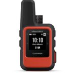
This compact satellite communicator1 helps you keep home with you when you’re off the grid — adding peace of mind to every adventure, without adding weight to your pack.
![]()
Global satellite coverage keeps you connected when mobile phones can’t.
![]()
In an emergency, send an interactive SOS message to our coordination centre.
![]()
You can still connect to the ones who matter, even without mobile phone coverage.
![]()
With TracBack® routing, find your way back if you happen to get lost.
![]()
Expand the capabilities of your inReach device by using the Garmin Explore™ app.
![]()
Stay on adventures longer with up to 14 days of battery life in 10-minute tracking mode.
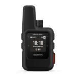
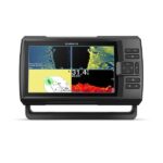
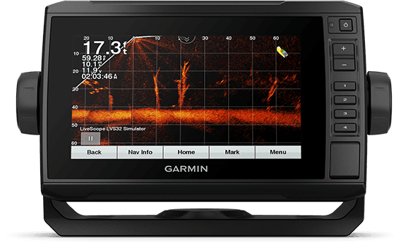
See fish and structure in maximum detail when you pick your display colour, your location and your sonar for your day on the water with the STRIKER Vivid 9sv fishfinder with transducer.
![]()
The sonar colour you pick says a lot about your fishing style. Good thing there are 7 new vivid options.
![]()
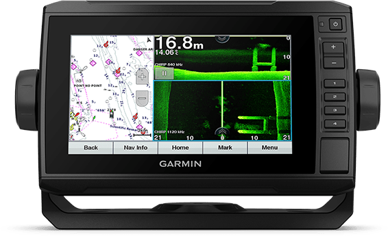
What a view. Use the included transducer to get CHIRP traditional and ClearVü sonars.
![]()
Never lose a hot spot again. Use waypoint marking to find your way back.
![]()
What’s under the water’s surface looks pretty good as 1-foot contours, just saying.
![]()
Wi-Fi® connection1 on land opens up a world of possibilities on the water.
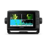
The sunlight-readable 7” touchscreen chartplotter features a quick-release bail mount, and the transducer bundle adds Ultra High-Definition scanning sonar and CHIRP traditional sonar.
See below and around your boat in incredible detail with included transducer.
Navigate any waters with preloaded Australia and New Zealand BlueChart® g3 coastal charts.
Share data and maps with select ECHOMAP devices on your network.
Manage your marine experience from nearly anywhere1.
Control the most powerful trolling motor available2.
Create your own maps on the fly and tailor them to fit your needs.
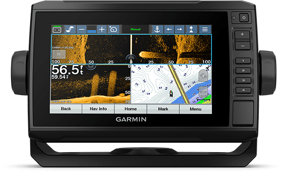
This chartplotter supports a variety of Garmin transducers (sold separately), including the Panoptix LiveScope™ scanning sonar system, which lets you see all around your boat in real time.

High-contrast vivid scanning sonar color palettes make it easier than ever to distinguish targets and structure.
This chartplotter comes with a GT56 transducer for Garmin CHIRP traditional sonar and Ultra High-Definition ClearVü and SideVü scanning sonars. With three scanning sonar frequencies and 20% greater range for our UHD SideVü sonar, you’ll get top performance at all depths.
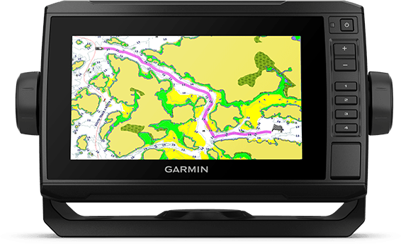
Experience unparalleled coverage and detail with preloaded Experience unparalleled coverage and detail with preloaded Australia and New Zealand BlueChart g3 coastal charts featuring integrated Navionics® data.
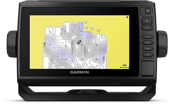
Create personalized fishing maps on-screen with 1’ contours. Keep the data to yourself, or share it with the Quickdraw Community on the Garmin Connect™ app3.
If you have multiple compatible ECHOMAP UHD or ECHOMAP Ultra devices on your boat, the 7” and 9” models can share information — such as sonar, user data and charts — with them.
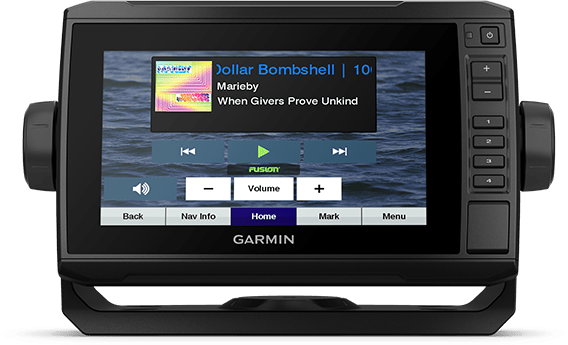
Connect to your compatible autopilots, digital switching, weather, Fusion-Link™ audio system, media, VHF, AIS, engine data, heading sensors — such as the SteadyCast™ sensor — and more from one screen.
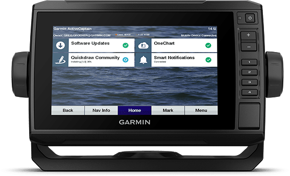
Built-in Wi-Fi® connectivity pairs with the free all-in-one mobile app for access to the OneChart™ feature, smart notifications, software updates, Garmin Quickdraw™ Community data and more1.
Take control of the most powerful and efficient trolling motor available2, route it to waypoints, follow tracks and more from the screen of your chartplotter.
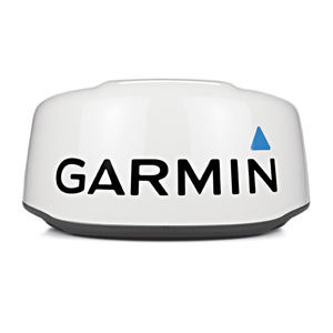
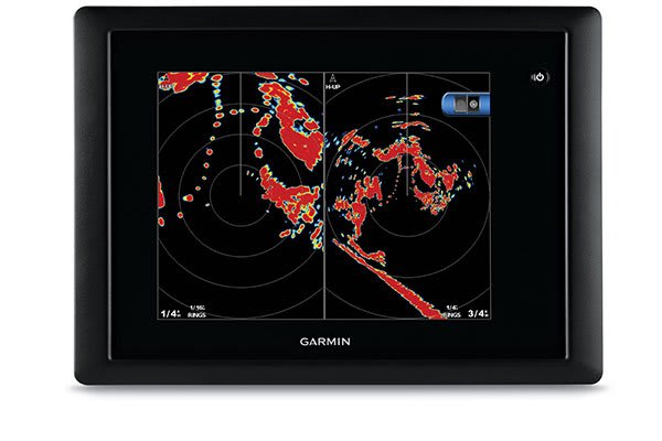
This 24-inch high-definition radar dome pairs ease of use with advanced features typically found on open arrays for enhanced situational awareness.
![]()
This 24-inch radar dome is easy to use and has options to make installation simple. What could be better?
![]()
It packs the power and echo definition you need, at all ranges.
![]()
When weather and sea conditions shift, the gain and sea filter do too — automatically.
![]()
See what’s close and far away with dual-range operation.
This 24-inch dome radar delivers 4-kW transmit power and clear echo definition at all ranges. It has a maximum range of 48 nautical miles (88 km) and 48- or 24-RPM rotation speeds for fast screen refreshes.
GMR™ 24 xHD features 8-bit true colour high resolution for outstanding target separation with less screen clutter on your chartplotter.
This radar doesn’t have any complex user settings to deal with, so it’s easy to install and start using.
Gain levels automatically adjust to optimum settings for harbours, near shore and offshore in open waters.
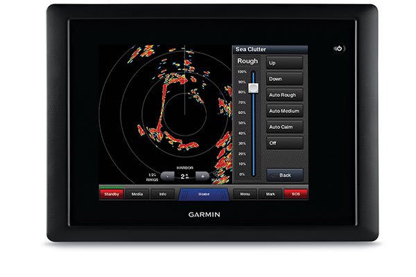
Gain automatically adjusts sea clutter for calm, medium and rough sea conditions.
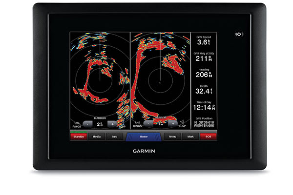
This feature enables the fully independent split-screen display of far and close radar views.
You have the option to protect areas behind the radar from being radiated while providing full forward-looking radar capability. This also makes installation more flexible.
Overlay radar images onto your chartplotter’s map page. You can add an optional autopilot or heading sensor (sold separately) for best results.
GMR™ 24 xHD provides MARPA target tracking when combined with a multifunction display and heading sensor (sold separately).
### GARMIN SALE – ONLINE ONLY DEAL – WHILE STOCKS LAST – MUST END###
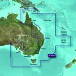
Garmin BlueChart g2 Vision – East Coast of Australia [Garmin Part Number: 010-C0756-00] – RRP $399
Get a fresh perspective when you take to the water with BlueChart® g2 Vision®. With BlueChart g2 Vision data, you’ll get detailed marine cartography that provides convenient viewing of nautical content and other premium features. BlueChart g2 Vision allows you to see your vessel’s precise, on-chart position in relation to naviads, coastal features, anchorages, obstructions, waterways, restricted areas and more. You will also have access to detailed mapping capabilities that include Safety Shading, Fishing Charts, smooth data transition between zoom levels, harmonious transition across chart borders, and reduction of chart discontinuities. Premium features include 3-D perspective above and below the waterline, Auto Guidance, high-resolution imagery, and “real picture” aerial photos of ports, harbours, marinas, waterways, landmarks and other points of interest. It’s the most realistic mapping display Garmin has ever offered.
Detailed coverage of the Eastern coast of Australia from Mornington Island to Fowlers Bay (VPC022R). Also includes detailed coverage of Cape York, the Great Barrier Reef, Brisbane, Sydney, Melbourne, Adelaide, Tasmania, and Norfolk Island (if another region is required please contact us for availability).
THIS IS SUITABLE FOR CURRENT MODEL GARMIN GPSMAP 7407xsv, GPSMAP 7408xsv, GPSMAP 7410xsv, GPSMAP 7412xsv, echoMAP 75dv, echoMAP 75sv & echoMAP 95sv SOUNDER/GPS COMBO UNITS, PLEASE SEE RELATED PRODUCTS OR ASK FOR FURTHER INFORMATION.
WARRANTY:
We are an authorised Australian Garmin retailer, as such Full Australian Manufacturers Warranty is applicable for this item. Please note if a Garmin unit is purchased overseas or from a non-authorised Garmin retailer you may not receive warranty coverage in Australia.
*Specifications from suppliers’ information. Actual depth capabilities depend on transducer installation, bottom type & water conditions. All sonars typically read deeper in freshwater than in saltwater. Images for display purposes only.