-
×
 Garmin 11mm Split Connector
1 × $1.95
Garmin 11mm Split Connector
1 × $1.95
Subtotal: $1.95

$1,499.00 $1,599.00

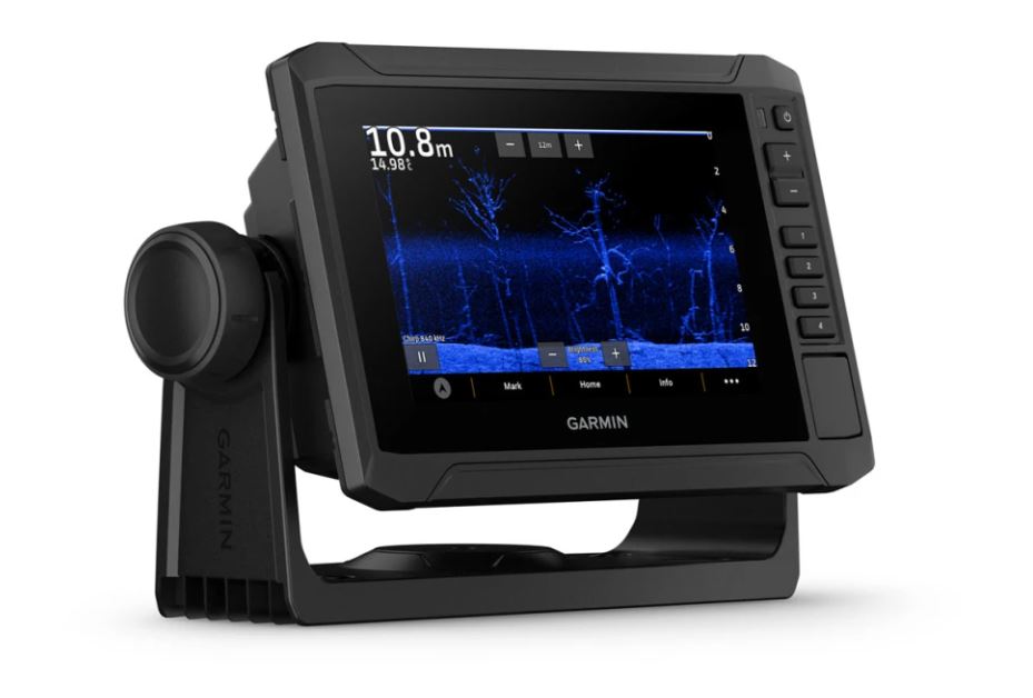
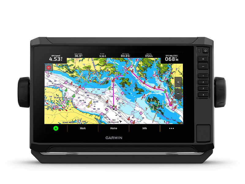
When it comes to catching more fish, they say, “Talk to a local.” With the Echomap UHD2 65sv chartplotter, which offers our best-in-class sonar and mapping and premium touchscreen display with keyed-assist, you’ll know the water even better than they do.
![]()
The bright 6″, 7″ or 9″ touchscreen display with keyed-assist is user-friendly and easy to read.
![]()
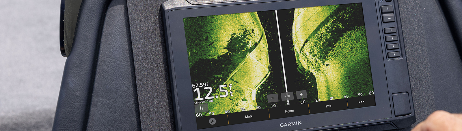
Good things come in threes. Three sonar types, that is: Garmin traditional, ClearVü™ and SideVü™ sonars.
![]()
Improved detail? Check. Distinguished targets? Yep. That’s the beauty of high-contrast vivid colour palettes.
![]()
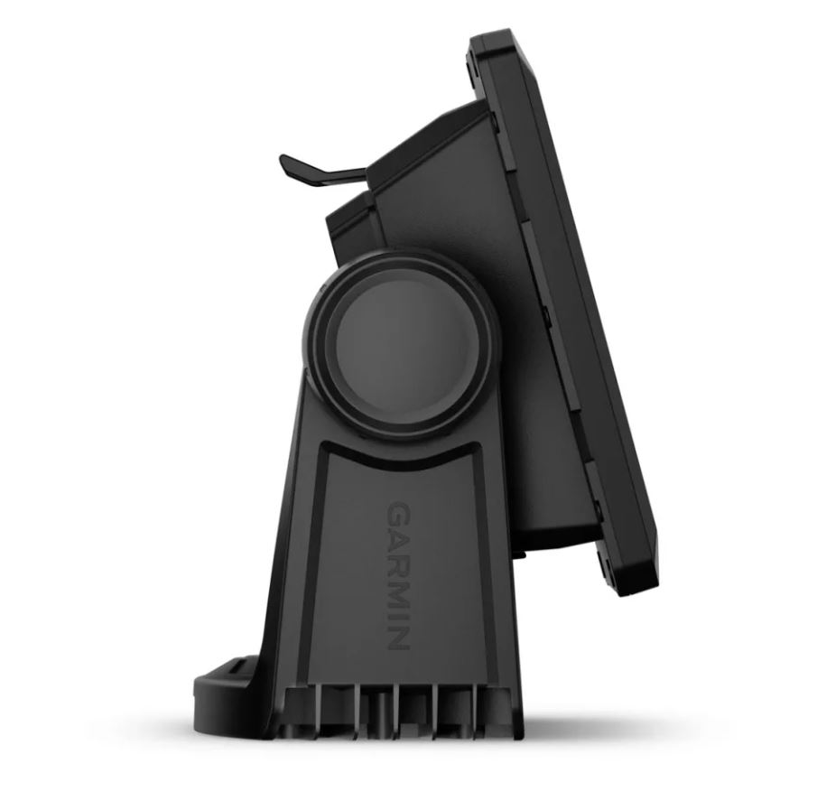
If you’re running another ECHOMAP UHD2 chartplotter, you can wirelessly share sonar, waypoints and routes.
![]()
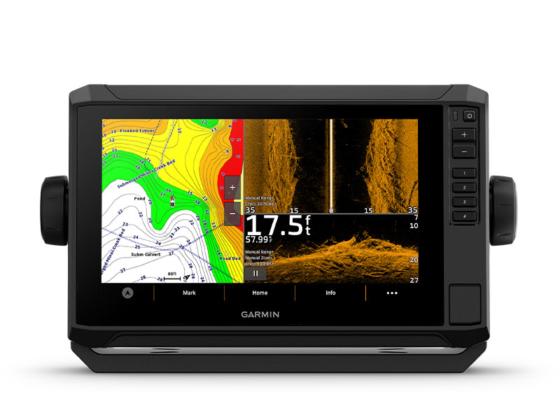
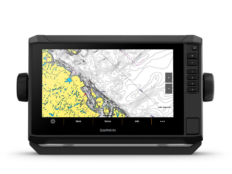
Want our best in mapping? Who doesn’t? Select chartplotters come with Garmin Navionics+™ mapping.
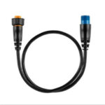
Use this adapter cable to connect an 8-pin transducer with XID to a 12-pin sonar port on a compatible marine device.
When it comes to catching more fish, they say, “Talk to a local.” With the Echomap UHD2 65sv chartplotter, which offers our best-in-class sonar and mapping and premium touchscreen display with keyed-assist, you’ll know the water even better than they do.
![]() The bright 6″ touchscreen display with keyed assist is user-friendly and easy to read.
The bright 6″ touchscreen display with keyed assist is user-friendly and easy to read.
![]() Good things come in threes. Three sonar types, that is Garmin traditional, ClearVü™ and SideVü™ sonars.
Good things come in threes. Three sonar types, that is Garmin traditional, ClearVü™ and SideVü™ sonars.
![]() Improved detail? Check. Distinguished targets? Yep. That’s the beauty of high-contrast vivid colour palettes.
Improved detail? Check. Distinguished targets? Yep. That’s the beauty of high-contrast vivid colour palettes.
![]() If you’re running another ECHOMAP UHD2 chartplotter, you can wirelessly share sonar, waypoints and routes.
If you’re running another ECHOMAP UHD2 chartplotter, you can wirelessly share sonar, waypoints and routes.
![]() Want our best in mapping? Who doesn’t? Select chartplotters come with Garmin Navionics+™ mapping.
Want our best in mapping? Who doesn’t? Select chartplotters come with Garmin Navionics+™ mapping.
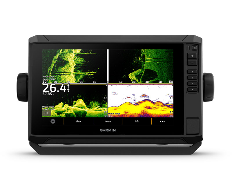
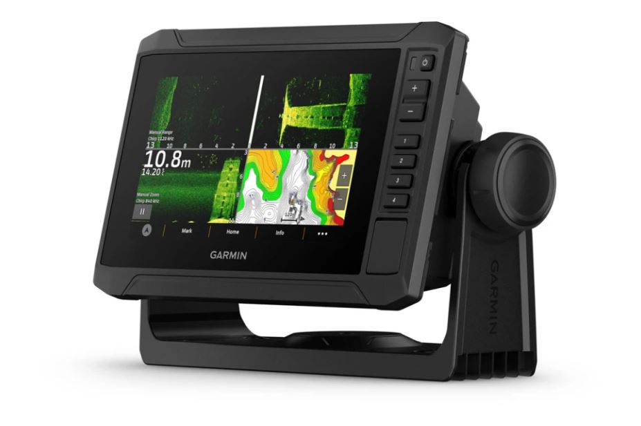
With crisp, clear traditional sonar and brilliant ClearVü and SideVü scanning sonars, the fish will have nowhere to hide. Your ECHOMAP UHD2 also supports LiveScope™ live-scanning sonar.

High-contrast vivid scanning sonar colour palettes make it easier than ever to distinguish targets and structure.
![]()
Your ECHOMAP UHD2 device supports a variety of Garmin transducers. The 6″ and 7″ chartplotters come bundled with a GT54 transducer — while the 9″ chartplotter comes with a GT56 transducer.

You’ve never seen Garmin cartography like this before. Select chartplotters come with built-in Garmin Navionics+ cartography which includes a 1-year subscription for daily updates, raster cartography and more.
If you have another compatible ECHOMAP UHD2 chartplotter on your boat, you can wirelessly share information — such as sonar1, waypoints and routes — with them.
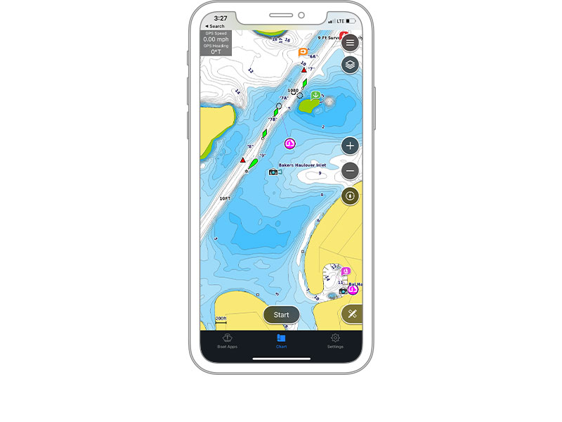
Built-in Wi-Fi® connectivity pairs with the free all-in-one mobile app for access to the OneChart™ feature, smart notifications2, software updates, Garmin QuickDraw Community data and more.
Chartplotters with built-in Garmin Navionics+ charts include downloadable Auto Guidance+ technology3 with the ActiveCaptain app.
Your ECHOMAP UHD2 wirelessly connects to your Force trolling motor to create and follow routes, navigate to waypoints, control speed, check battery life and more.

Get improved position accuracy, particularly in areas where signals are reflected or weak, with multi-band GPS.
 What’s in The Box:
| Weight | 0.8 kg |
|---|
General |
|
| DIMENSION | 8.1″ x 5.2″ x 2.6″ (20.6 x 13.1 x 6.7 cm) |
| WEIGHT | 1.8 lbs (0.8 kg) |
| WATERPROOF | IPX7 |
| TOUCHSCREEN | ✔ |
| DISPLAY TYPE | WVGA, TN |
| DISPLAY SIZE | 5.4″ x 3.1″, 6.2″ (13.8 x 7.8 cm, 15.7 cm) |
| DISPLAY RESOLUTION | 800 x 480 pixels |
| MOUNTING OPTIONS | Bail or flush |
| INPUT | Touchscreen with Keyed Assist |
Maps & Memory |
|
| ACCEPTS DATA CARDS | 1 microSD™ card; 32 GB maximum size |
| WAYPOINTS | 5000 |
| TRACK POINTS | 50000 |
| TRACKS | 50 saved tracks |
| NAVIGATION ROUTES | 100 |
Sensors |
|
| GPS | ✔ |
| GLONASS | ✔ |
| GALILEO | ✔ |
| BEIDOU | ✔ |
| HAS BUILT-IN RECEIVER | ✔ |
| RECEIVER | 10 Hz |
| NMEA 2000 COMPATIBLE | ✔ |
| SUPPORTS WAAS | ✔ |
| SUPPORTS MULTI-BAND, MULTI-CONSTELLATION GPS | ✔ |
Built-in maps |
|
| BUILT-IN AUTO GUIDANCE+ | Yes (downloadable via ActiveCaptain app) |
| GARMIN NAVIONICS+ INLAND & COASTAL | Yes (see Additional) |
| GARMIN NAVIONICS+™ (COASTAL) | Yes (see Additional) |
| GARMIN NAVIONICS+ (INLAND) | Yes (see Additional) |
| BLUECHART (COASTAL) | Yes (see Additional) |
| TIDE TABLES | Yes (see Additional) |
Optional map support |
|
| GARMIN NAVIONICS+™ | ✔ |
| GARMIN NAVIONICS VISION+™ | ✔ |
| TOPO | ✔ |
| STANDARD MAPPING | ✔ |
| GARMIN QUICKDRAW CONTOURS | ✔ |
Chartplotter Features |
|
| AIS | ✔ |
| DSC | ✔ |
| SUPPORTS FUSION-LINK™ COMPATIBLE RADIOS | ✔ |
| ACTIVECAPTAIN MOBILE PLANNING COMPATIBLE | ✔ |
| SAILING FEATURES | ✔ |
Electrical features |
|
| POWER INPUT | 9 to 18 Vdc |
| TYPICAL CURRENT DRAW AT 12 VDC | 1.53 A |
| MAXIMUM CURRENT DRAW AT 12 VDC | 3.2 A |
| MAXIMUM POWER USAGE AT 10 VDC | 18.4W |
Sonar Features & Specifications |
|
| DISPLAYS SONAR | ✔ |
| POWER OUTPUT | 500W |
| TRADITIONAL SONAR (DUAL FREQUENCY/BEAM) | Built-in (single channel CHIRP, 70/83/200 kHz, L, M, H CHIRP) |
| CLEARVÜ | Built-in 260/455/800/1000/1200 kHz |
| SIDEVÜ | Built-in 260/455/800/1000/1200 kHz |
| PANOPTIX™ SONAR | ✔ |
| LIVESCOPE | ✔ |
Connections |
|
| NMEA 2000® PORTS | ✔ |
| GARMIN MARINE NETWORK PORTS | 1 |
| 12-PIN TRANSDUCER PORTS | 1 |
| BLUETOOTH® PAIRING | ✔ |
| ANT+ (CONNECTIVITY) | ✔ |
| GARMIN WI-FI NETWORK (LOCAL CONNECTION) | ✔ |
Additional |
|
| ADDITIONAL | · Garmin Navionics+ (inland and coastal): 65sv Canada, Australia and New Zealand
· Garmin Navionics+ (coastal): 64sv U.S. coastal, 65sv UK/Ireland · Garmin Navionics+ (inland): 63sv U.S. lakes · Tide tables: 63sv, 64sv, 65sv
|
The 9-axis heading sensor is our premium solution that is easy to install and provides fast calibration and exceptional heading accuracy.
Its heading output at 10 Hz and accuracy of plus or minus 2 degrees ensures your chart orientation and boat heading line match up with reality, even at lower speeds. It also allows for MARPA tracking and improves radar overlay experience.
You can also be confident your heading information will remain accurate, even in rough sea conditions where your bow is pitching and rolling or — in sailboat applications — when heeled over. Provides heading and rate-of-turn output at 10 Hz and trim and heel output at 1 Hz.
The 9-axis heading sensor installs easily with NMEA 2000® plug-and-play interface and a simple 2-step precision calibration process for compatible Garmin chartplotters. For displays other than Garmin, basic calibration is also supported. The heading sensor’s 9-axis MEMS technology allows installation in any orientation located away from magnetic interference. All of our heading sensors are built to withstand bilge environments.
The easy-to-use GRID 20 remote input device provides intuitive remote access and control of your entire Garmin marine system. It features a 360-degree joystick with a rotary knob and push-to-select button for easy chartplotter menu/setting navigation and fine control, even in the worst conditions. You can designate 4 favourite keys to restore your system to a previously saved configuration. There are also a variety of hard keys for quick access to important functions, including left and right screen switches, autopilot standby/engage and more. For peace of mind, there’s also a dedicated SOS key. Wired or wireless installation and vertical or horizontal options allow for a plug-and-play solution that is tailored to your marine system. Its small footprint makes it convenient to integrate into a busy helm between displays — or even into the arm of the captain’s chair.
With the GFL 10 Fluid Level Analog Adapter aboard your vessel, you can give new life to your old gauges by making the transition from analog to digital. This simple-to-install adapter takes the data generated by traditional analog gauges and converts the data into a NMEA 2000® signal so you can create or expand your network without replacing all of the equipment on your boat.
With the GFL 10 adapter, you can convert analog information provided via the fluid-level sensor (not included) on your boat to your NMEA 2000 network. The GFL 10 allows you to observe fluid-level information on compatible Garmin display devices connected to your NMEA 2000 network.
The NMEA 2000 analog adapters from Garmin are easy to add to any existing marine network. Once installed, the data from the adapters can be viewed via the GMI™ 10 Marine Instrument Display and other compatible Garmin devices. This easy-to-use set-up will help you bring your older dashboard into the digital age.
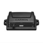
Garmin Marine Heading Sensor for Radar [Garmin Part Number: 010-11417-00] – RRP $1200
When interfacing this 3-axis compass heading sensor to our marine lineup of MFDs and radars, mariners can expect unparalleled radar overlay performance and accuracy along with excellent MARPA capabilities.
This heading sensor (based on Airmar H2183) uses a rate gyro, so it can maintain an exceptional 2 degree heading accuracy under heavy dynamic conditions, with up to 30 degrees of pitch and roll. In addition, it supports either NMEA 0183 or NMEA 2000® data output to fit any installation.
Installation is a snap thanks to the heading sensor’s innovative design, allowing it to mount to any angled bulkhead. Mariners can expect this heading sensor to provide trouble-free service in the harshest conditions and will learn to appreciate its reliability and excellent performance.
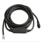
* Note: NMEA 0183 and NMEA 2000 cables sold separately (to connect to a NMEA 2000 Network a dedicated NMEA 2000 Marine Heading Sensor Cable is required Garmin Part Number: 010-11419-00 – optional, please see related products).
THIS IS SUITABLE FOR CURRENT MODEL GARMIN GMR 18 xHD RADOME & GMR 24 xHD RADOME.
FEATURES:
* Better than 1 degree static heading accuracy
* Industry leading 2 degree dynamic accuracy up to 30 degree pitch and roll
* Three-axis solid-state compass provides accurate heading data
* Three-axis accelerometer improves heading, pitch and roll in static conditions
* Three-axis rate gyro improves heading, pitch and roll in dynamic conditions
* Temperature compensated across the entire operating range to ensure optimum accuracy
* Easy installation to any angled bulkhead
* Auto-calibration feature
SPECIFICATIONS:
* Dimensions (HxLxD): 2″ (5.08 cm) x 4.4″ (11.18 cm) x 4.5″ (11.43 cm)
* Default heading output: 10 Hz for both NMEA 0183 and NMEA 2000 (NMEA 2000 can be output up to 20 Hz)
* Waterproof housing: IPX6
* Operating voltage: 9 VDC to 16 VDC
WHAT’S IN THE BOX:
* Garmin Marine Heading Sensor
* Documentation
WARRANTY:
We are an authorised Australian Garmin retailer, as such Full Australian Manufacturers Warranty is applicable for this item. Please note if a Garmin unit is purchased overseas or from a non-authorised Garmin retailer you may not receive warranty coverage in Australia.
*Specifications from suppliers’ information.
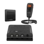
Garmin VHF 315i Marine Radio – Enjoy Reliable Communication
The 25-watt VHF 315i marine radio with Class D DSC is a modular communication solution. It provides the security of reliable communication and full NOAA weather alerts on the water by meeting the latest industry standards. It’s easy to use and integrates seamlessly into the Garmin onboard system. It has a built-in GPS receiver with connector for required external antenna. VHF 315i includes a GHS 11 handset and new active speaker to use as an intercom between up to 3 stations. It’s also equipped with a two-way 30-watt hailer system for communication with other boats or deckhands. NMEA 2000 connectivity enables easy integration with compatible chartplotters, multifunction displays and convenient software updates. Simplified handset connectors and an uncomplicated, easy-to-use interface allow you to get your radio set up quickly, so you can get back out on the water and start communicating.
Specs
In the Box
Airmar’s TM185M is a transom-mounted, Chirp-ready transducer designed for offshore fishing and freshwater anglers spending their time in shallow to mid-range depths. The medium frequency delivers the right combination of coverage under the boat, extended depth range, and the ability to produce clean and accurate target and structure returns in mid to deeper water. Medium frequency also provides excellent shallow to mid-depth performance, bottom detail, and fish-target separation. Operating at a frequency range of 85 to 135 kHz, this transducer reveals fish at medium depths down to 457 m (1500′) and gives ultra-clear target resolution.
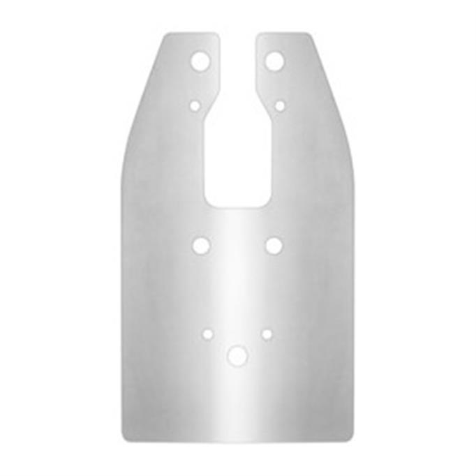
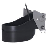
The Garmin spray shield is designed to reduce excess water spray from transducers when the vessel is running at high speeds. Can be retro fitted to a wide range of common Garmin transom mounted transducers. The plate is simply fitted between the plastic transducer housing and the transom mount bracket. Supplied complete with stainless steel mount fixtures and washers.
COMPATABLE UNITS & TRANSDUCERS:
* echoMAP™ 45dv
* echoMAP™ 55dv
* echoMAP™ 75dv
* echoMAP™ 75sv
* echoMAP™ 95sv
* echoMAP™ CHIRP 45dv
* echoMAP™ CHIRP 55dv
* echoMAP™ CHIRP 75dv
* echoMAP™ CHIRP 75sv
* echoMAP™ CHIRP 95sv
* Garmin GT20-TM – Transom Mount DownVü 500 W (CHIRP 455/800 kHz) Traditional 500 W (77/200 kHz) Transducer with Temp (8-pin)
* Garmin GT21-TM – Transom Mount DownVü 500 W (CHIRP 260/455 kHz) Traditional 600 W (50/200 kHz) Transducer with Temp (8-pin)
* Garmin GT30-TM – Transom Mount DownVü/SideVü 500 W (CHIRP 455/800 kHz) Scanning Transducer with Temp (12-pin)
* Garmin GT40-TM – Transom Mount DownVü/SideVü 500 W (CHIRP 455/800 kHz) Traditional 500 W (77/200 kHz) Transducer with Temp (12-pin)
* Garmin GT41-TM – Transom Mount DownVü/SideVü 500 W (CHIRP 260/455 kHz) Traditional 600 W (50/200 kHz) Transducer with Temp (12-pin)
* Garmin GT50M-TM – Transom Mount DownVü/SideVü 500 W (CHIRP 455/800 kHz) Traditional 300 W (Mid-band CHIRP 80-160 kHz) Transducer with Temp (12-pin)
* Garmin GT51M-TM – Transom Mount DownVü/SideVü 500 W (CHIRP 260/455 kHz) Traditional 600 W (Mid-band CHIRP 80-160 kHz) Transducer with Temp (12-Pin)
*Specifications from suppliers’ information.