Subtotal: $479.00
-6%


EOFY, Garmin, Garmin Chartplotters, Sanctuary Cove
Price Match
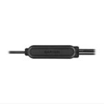
Garmin Echomap UHD2 75sv – 7″ Chartplotter with GT54UHD-TM Transducer and Garmin Navionics+ Australia & New Zealand Mapping
Price Match
$1,699.00 $1,799.00
-
EOFY, Garmin, Garmin Chartplotters, Sanctuary Cove
Garmin Echomap UHD2 75sv – 7″ Chartplotter with GT54UHD-TM Transducer and Garmin Navionics+ Australia & New Zealand Mapping
-6%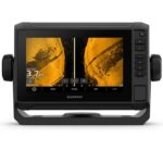 EOFY, Garmin, Garmin Chartplotters, Sanctuary Cove
Garmin Echomap UHD2 75sv – 7″ Chartplotter with GT54UHD-TM Transducer and Garmin Navionics+ Australia & New Zealand Mapping
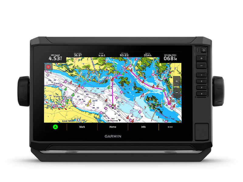
Garmin Echomap UHD2 75sv – 7″ Chartplotter with GT54UHD-TM Transducer and Garmin Navionics+ Australia & New Zealand Mapping – KNOW THE WATER BETTER THAN A LOCAL
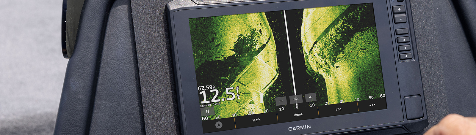
When it comes to catching more fish, they say, “Talk to a local.” With the Garmin Echomap UHD2 75sv 7″ Chartplotter, which offers our best-in-class sonar and mapping and premium touchscreen display with keyed-assist, you’ll know the water even better than they do.

The bright 6″, 7″ or 9″ touchscreen display with keyed-assist is user-friendly and easy to read.

Good things come in threes. Three sonar types, that is: Garmin traditional, ClearVü™ and SideVü™ sonars.

Improved detail? Check. Distinguished targets? Yep. That’s the beauty of high-contrast vivid colour palettes.

If you’re running another ECHOMAP UHD2 chartplotter, you can wirelessly share sonar, waypoints and routes.

Want our best in mapping? Who doesn’t? Select chartplotters come with Garmin Navionics+™ mapping.
SKU: 010-02686-20 -
Garmin, Garmin Trolling Motors, Sanctuary Cove
Garmin Force® 57″ Trolling Motor
Garmin Force® 57″ Trolling Motor – FISH WITH FORCE
Get on fish faster, and stay on the water with the most powerful, most efficient trolling motor available1 — and it’s quiet, too.

Force is more efficient at 24 V than the competition’s 36 V system. No lie.

Wirelessly connect to your Garmin chartplotter, and open up a world of possibilities.

It comes with sonar built in, too? That’s just too good to be true.

All the control of a cable-steered pedal without the cable.

Just point the handheld remote where you want to go, and Force will take you there.
SKU: 010-02025-00 -
Garmin, Garmin Sonar & Transducers, Marine Electronics, Transducers
Garmin GT54UHD-TM Transducer – Ultra High-Definition Scanning Sonar All-in-one Transducer
-8%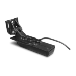 Garmin, Garmin Sonar & Transducers, Marine Electronics, Transducers
Garmin GT54UHD-TM Transducer – Ultra High-Definition Scanning Sonar All-in-one Transducer
Garmin GT54UHD-TM Transducer – Ultra High-Definition Scanning Sonar All-in-one Transducer
All-in-one Transducer
- One transducer provides the highest resolution ClearVü and SideVü scanning sonar images available and amazingly clear high wide CHIRP traditional sonar
- High wide CHIRP traditional sonar provides remarkably clear target separation and definition
- See incredibly detailed images of fish and structure up to 200’ below your boat with 800 kHz ClearVü sonar
- Two SideVü sonar frequency settings (455/1200 kHz) provide options for extended range of up to 500’
- Easy-to-install, compact, all-in-one design includes transom and trolling motor mounts
Ultra-high Clarity
The GT54UHD-TM transducer provides image details so clear and precise, you can actually see fish hanging just off branches of submerged trees, brush and rocks. You can see size differences between bigger and smaller fish and even see individual fish swimming in bait balls. You get the highest resolution ClearVü and SideVü scanning sonar images available plus amazingly clear high wide CHIRP traditional sonar1 — all in one transducer.
Ultra-high Performance
Ultra High-Definition scanning sonar provides extended range and depth performance. It shows you incredibly detailed images of fish and structure up to 200’ below your boat with 800 kHz ClearVü, while two SideVü sonar frequency settings (455/1200 kHz) provide options for extended range of up to 500’. It’s easy to install with included transom and trolling motor mounts so you can start fishing faster.
¹For use with GPSMAP® 8400xsv/8600xsv chartplotter/sonar combos
SKU: 010-12909-000

$7,377.00 for 3 item(s)
Garmin Echomap UHD2 75sv – KNOW THE WATER BETTER THAN A LOCAL
When it comes to catching more fish, they say, “Talk to a local.” With the Garmin Echomap UHD2 75sv 7″ Chartplotter, which offers our best-in-class sonar and mapping and premium touchscreen display with keyed-assist, you’ll know the water even better than they do.
![]() The bright 7″ touchscreen display with keyed-assist is user-friendly and easy to read.
The bright 7″ touchscreen display with keyed-assist is user-friendly and easy to read.
![]() Good things come in threes. Three sonar types, that is: Garmin traditional, ClearVü™ and SideVü™ sonars.
Good things come in threes. Three sonar types, that is: Garmin traditional, ClearVü™ and SideVü™ sonars.
![]() Improved detail? Check. Distinguished targets? Yep. That’s the beauty of high-contrast vivid colour palettes.
Improved detail? Check. Distinguished targets? Yep. That’s the beauty of high-contrast vivid colour palettes.
![]() If you’re running another ECHOMAP UHD2 chartplotter, you can wirelessly share sonar, waypoints and routes.
If you’re running another ECHOMAP UHD2 chartplotter, you can wirelessly share sonar, waypoints and routes.
![]() Want our best in mapping? Who doesn’t? Select chartplotters come with Garmin Navionics+™ mapping.
Want our best in mapping? Who doesn’t? Select chartplotters come with Garmin Navionics+™ mapping.
It doesn’t get any better than this.
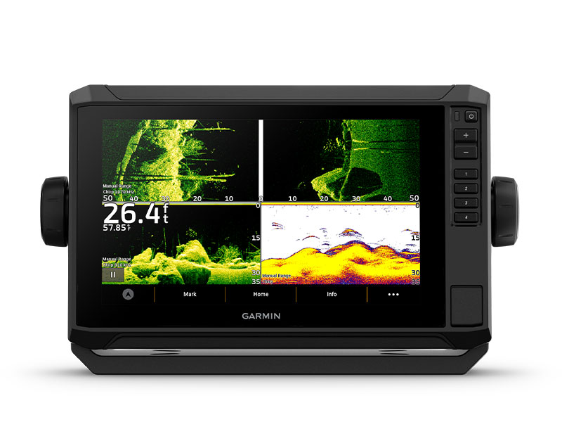
SONAR SUPPORT
With crisp, clear traditional sonar and brilliant ClearVü and SideVü scanning sonars, the fish will have nowhere to hide. Your ECHOMAP UHD2 also supports LiveScope™ live-scanning sonar.

VIVID COLOUR PALETTES
High-contrast vivid scanning sonar colour palettes make it easier than ever to distinguish targets and structure.
![]()
BUNDLE YOUR TRANSDUCER
Your ECHOMAP UHD2 device supports a variety of Garmin transducers. The 6″ and 7″ chartplotters come bundled with a GT54 transducer — while the 9″ chartplotter comes with a GT56 transducer.

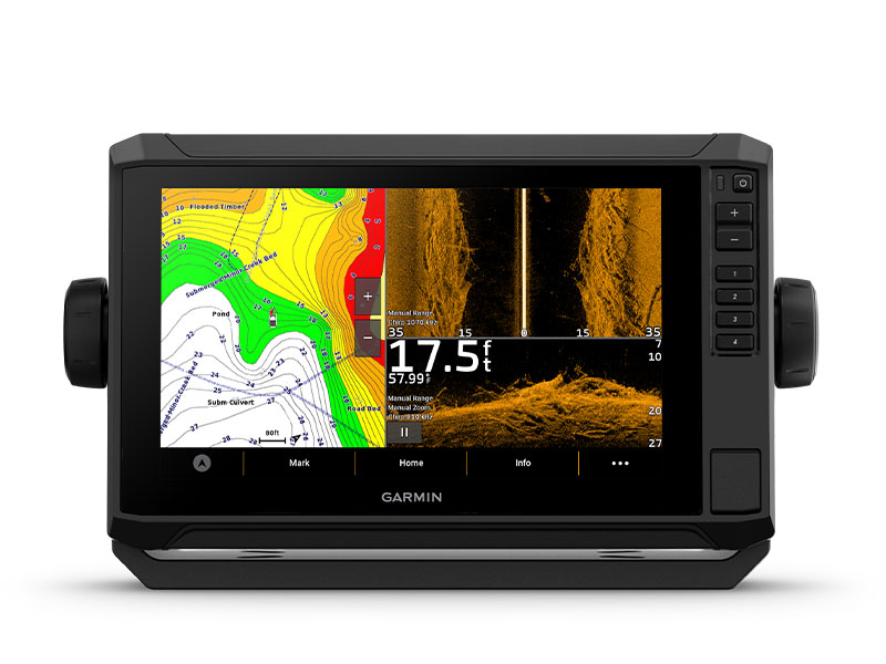
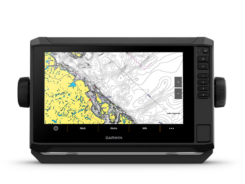
PRELOADED CHARTS
You’ve never seen Garmin cartography like this before. Select chartplotters come with built-in Garmin Navionics+ cartography which includes a 1-year subscription for daily updates, raster cartography and more.
WIRELESS NETWORKING
If you have another compatible ECHOMAP UHD2 chartplotter on your boat, you can wirelessly share information — such as sonar1, waypoints and routes — with them.
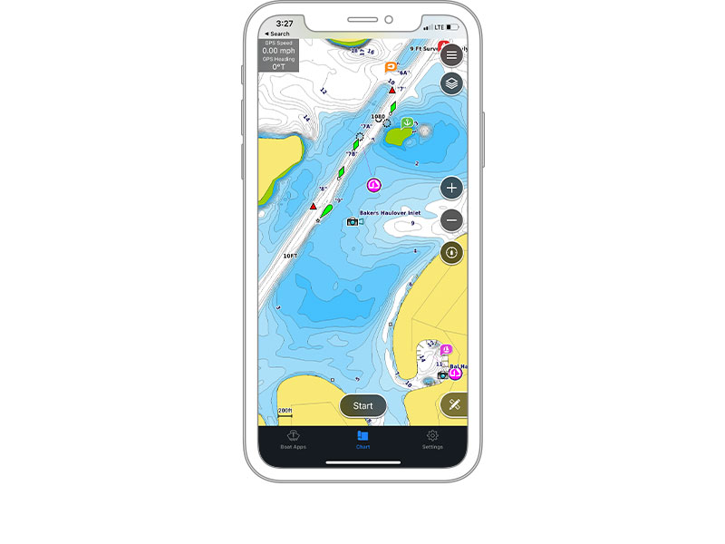
ACTIVECAPTAIN® APP
Built-in Wi-Fi® connectivity pairs with the free all-in-one mobile app for access to the OneChart™ feature, smart notifications2, software updates, Garmin QuickDraw Community data and more.
AUTO GUIDANCE+™ TECHNOLOGY
Chartplotters with built-in Garmin Navionics+ charts include downloadable Auto Guidance+ technology3 with the ActiveCaptain app.
TROLL WITH FORCE®
Your ECHOMAP UHD2 wirelessly connects to your Force trolling motor to create and follow routes, navigate to waypoints, control speed, check battery life and more.

MULTI-BAND GPS
Get improved position accuracy, particularly in areas where signals are reflected or weak, with multi-band GPS.
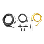
 What’s in the Box?
- ECHOMAP UHD2 (device varies depending on selection)
- GT54-TM transducer
- Power cable
- Tilt/swivel mount with quick release cradle
- Protective cover
- Hardware
- Documentation
View Installation Instructions
View Owner’s Manual
Garmin Echomap UHD2 | Best-in-class Sonar & Mapping
| Weight | 1 kg |
|---|---|
| User Interface & Sonar Type | Keyed Interface + Ultra High-Def ClearVU and Traditional Chirp Sonar, Touchscreen with Keyed Assist + Ultra High-Def SideVU, ClearVU and Traditional Chirp |
75cv with GT20-TM Transducer and Garmin Navionics+ Australia & New Zealand Mapping |
75sv with GT54UHD-TM Transducer and Garmin Navionics+ Australia & New Zealand Mapping |
|
General |
||
| DIMENSION | 9.1″ x 5.6 x 2.6″ (23.2 x 14.3 x 6.7 cm) | 8.6″ x 5.6″ x 3.2″ (21.8 x 14.2 x 8.1 cm) |
| WEIGHT | 1.5 lbs (0.7 kg) | 2.2 lbs (1 kg) |
| WATERPROOF | IPX7 | IPX7 |
| DISPLAY TYPE | WVGA, TN | WVGA, TN |
| DISPLAY SIZE | 6.1″ x 3.4″ (15.5 x 8.7 cm) | 6.1″ x 3.4″, 7″ (15.5 x 8.7 cm, 17.8 cm) |
| DISPLAY RESOLUTION | 800 x 480 pixels | 800 x 480 pixels |
| MOUNTING OPTIONS | Bail or flush | Bail or flush |
| INPUT | Keyed | Touchscreen with Keyed Assist |
Maps & Memory |
||
| ACCEPTS DATA CARDS | 1 microSD™ card; 32 GB maximum size | 1 microSD™ card; 32 GB maximum size |
| WAYPOINTS | 5000 | 5000 |
| TRACK POINTS | 50000 | 50000 |
| TRACKS | 50 saved tracks | 50 saved tracks |
| NAVIGATION ROUTES | 100 | 100 |
Sensors |
||
| GPS | ✔ | ✔ |
| GLONASS | — | ✔ |
| GALILEO | ✔ | ✔ |
| BEIDOU | — | ✔ |
| HAS BUILT-IN RECEIVER | ✔ | ✔ |
| RECEIVER | 5 Hz | 10 Hz |
| NMEA 2000 COMPATIBLE | — | ✔ |
| SUPPORTS WAAS | ✔ | ✔ |
| SUPPORTS MULTI-BAND, MULTI-CONSTELLATION GPS | — | ✔ |
Built-in maps |
||
| BUILT-IN AUTO GUIDANCE+ | Yes (downloadable via ActiveCaptain app) | Yes (downloadable via ActiveCaptain app) |
| GARMIN NAVIONICS+ INLAND & COASTAL | Yes (see Additional) | Yes (see Additional) |
| GARMIN NAVIONICS+™ (COASTAL) | Yes (see Additional) | Yes (see Additional) |
| GARMIN NAVIONICS+ (INLAND) | Yes (see Additional) | Yes (see Additional) |
| BLUECHART (COASTAL) | Yes (see Additional) | Yes (see Additional) |
| TIDE TABLES | Yes (see Additional) | Yes (see Additional) |
Optional map support |
||
| GARMIN NAVIONICS+™ | ✔ | ✔ |
| GARMIN NAVIONICS VISION+™ | ✔ | ✔ |
| TOPO | ✔ | ✔ |
| STANDARD MAPPING | ✔ | ✔ |
| GARMIN QUICKDRAW CONTOURS | ✔ | ✔ |
Chartplotter Features |
||
| AIS | — | ✔ |
| DSC | — | ✔ |
| SUPPORTS FUSION-LINK™ COMPATIBLE RADIOS | — | ✔ |
| ACTIVECAPTAIN MOBILE PLANNING COMPATIBLE | ✔ | ✔ |
| SAILING FEATURES | — | ✔ |
Electrical features |
||
| POWER INPUT | 9 to 18 Vdc | 9 to 18 Vdc |
| TYPICAL CURRENT DRAW AT 12 VDC | 1 A | 1.52 A |
| MAXIMUM CURRENT DRAW AT 12 VDC | 1.5 A | 3.2 A |
| MAXIMUM POWER USAGE AT 10 VDC | 18W | 18.3W |
Sonar Features & Specifications |
||
| DISPLAYS SONAR | ✔ | ✔ |
| POWER OUTPUT | 500W | 500W |
| TRADITIONAL SONAR (DUAL FREQUENCY/BEAM) | Built-in (single channel CHIRP, 70/83/200 kHz, L, M, H CHIRP) | Built-in (single channel CHIRP, 70/83/200 kHz, L, M, H CHIRP) |
| CLEARVÜ | Built-in 260/455/800/1000/1200 kHz | Built-in 260/455/800/1000/1200 kHz |
| SIDEVÜ | — | Built-in 260/455/800/1000/1200 kHz |
| PANOPTIX™ SONAR | — | ✔ |
| LIVESCOPE | — | ✔ |
Connections |
||
| NMEA 2000® PORTS | — | ✔ |
| GARMIN MARINE NETWORK PORTS | — | 1 |
| 4-PIN TRANSDUCER PORTS | 1 | — |
| 12-PIN TRANSDUCER PORTS | — | 1 |
| BLUETOOTH® PAIRING | — | ✔ |
| ANT+ (CONNECTIVITY) | — | ✔ |
| GARMIN WI-FI NETWORK (LOCAL CONNECTION) | ✔ | ✔ |
Additional |
||
| ADDITIONAL | · Garmin Navionics+ (coastal): 74cv U.S., 75cv U.K./Ireland
· Tide tables: 53cv, 54cv, 55cv, 73cv, 74cv, 75cv
|
· Garmin Navionics+ (inland and coastal): 75sv Canada, Australia and New Zealand
· Garmin Navionics+ (coastal): 74sv U.S. coastal, 75sv UK/Ireland · Garmin Navionics+ (inland): 73sv U.S. lakes · Tide tables: 73sv, 74sv, 75sv |
You may also like…
-
Garmin, Garmin Accessories, Sanctuary Cove
Garmin GPS 24xd NMEA 2000 – White
Garmin GPS 24xd NMEA 2000 – EXPLORE COASTAL WATERS
The GPS 24xd position receiver and antenna gives you precise location with multi-band GNSS and heading accuracy even at slow speeds.

Navigate in more locations with expanded GNSS support.

Get high-sensitivity tracking with fast GPS update rate.

Accurately pinpoint your heading — regardless of speed.

It’s water-resistant (IPX7) to withstand the elements.

Install it easily with multiple mounting options.

The antenna is compatible with NMEA 2000® devices.

More accurate data — for more confident navigation.
MULTI-BAND GNSS
Multi-band GNSS provides precise location accuracy1 to within 1 metre to compatible marine multifunction displays, instrument displays and autopilots.
MAGNETIC HEADING
The magnetic heading sensor provides accuracy to within 3 degrees, stabilising charts, radar overlay and MARPA even at slow speeds.
HIGH-SENSITIVITY GPS
Fast 10 Hz position update rates provide high-sensitivity position, velocity and time data.
EXPANDED GNSS SUPPORT
GPS 24xd provides access to four key global navigation satellite systems (GPS, Galileo2, GLONASS and BeiDou2) to more accurately track in challenging conditions than GPS alone.
MULTI-SBAS COMPATIBLE
Multi-SBAS compatibility corrects signal measurement errors and provides information about the accuracy, integrity, continuity and availability of its signals.
MOUNTING OPTIONS
Installation is easy with under-deck, pole and surface-mount options.
11 < 1 metre CEP, < 3 metres 95%2Supported when available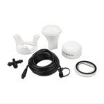 What’s in the box?
- GPS 24xd NMEA 2000®
- Pole mount
- Surface mount
- Under-deck mount
- NMEA 2000 backbone/drop cable (6 metres)
- NMEA 2000 T-connector
- Documentation
Installation Instructions
Setting Up A NMEA Network and Installing a Garmin GPS 24XD on a boat
SKU: 010-02316-10 -
Garmin, Garmin Accessories, Sanctuary Cove
Garmin NMEA 2000 Starter Kit
Garmin NMEA 2000 Starter Kit
Our starter kit has everything you need to build a basic NMEA 2000 network on your boat. The kit includes an NMEA 2000 drop cable (2 m), backbone cable (6 m), power cable (2 m), 2 T-connectors, and male and female terminator connectors.
SKU: 010-11442-00 -
Garmin, Garmin Accessories
Garmin GNA 10 – NMEA 2000 Multi-Function Adapter For Reactor 40 Autopilots
 Garmin, Garmin Accessories
Garmin GNA 10 – NMEA 2000 Multi-Function Adapter For Reactor 40 Autopilots
Garmin GNA 10 – NMEA 2000 Multi-Function Adapter For Reactor 40 Autopilots
Use the Garmin GNA 10 to connect a jog lever to our Reactor 40 autopilots1 on displacement hull boats. A jog lever is a rugged and simple steering control for work boats or trawlers. Adjust heading hold with the jog lever by pressing it right or left, or put the autopilot into the new Power Steering mode to move the rudder without autopilot guidance. The GNA 10 can also optionally connect to a button and LED light to allow switching between heading hold and standby2. Garmin does not supply the jog lever, button or LED light.
Installation Instructions
SKU: 010-13007-00 -
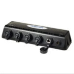
Garmin, Garmin Accessories, Sanctuary Cove
Garmin GMS 10 Network Port Expander
Garmin GMS 10 Network Port Expander
The GMS 10 Network Port Expander allows you to connect multiple chartplotters and sensors over the Garmin Marine Network. With this robust 100-megabit switch, you can connect multiple MFDs and sensors to the Garmin Marine Network and gain the benefit of Ethernet-like data transfer speeds up to 10 times faster than some competitive systems.
Just Plug and Play
The GMS 10 and the Garmin Marine Network are completely plug-and-play, which means that all peripherals are automatically detected and readily accessible once they’re connected to the network. Likewise, you can easily expand your system using the same standard data cable to plug additional units and displays into the GMS 10 network ports.
Waterproof Your Connections
The rugged GMS 10 is specifically designed to withstand the corrosive marine environment. All connections are totally waterproof, and sealed covers keep harmful moisture away from unused data ports.
GMS 10: Expand your network to its fullest potential
SKU: 010-00351-00
Related products
-
Garmin, Garmin Accessories
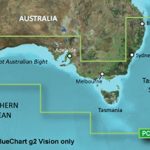
Garmin BlueChart g3 Vision – Southern Australia
Garmin BlueChart g2 Vision – Southern Australia [Garmin Part Number: 010-C0753-00] – RRP $399
Get a fresh perspective when you take to the water with BlueChart® g2 Vision®. With BlueChart g2 Vision data, you’ll get detailed marine cartography that provides convenient viewing of nautical content and other premium features. BlueChart g2 Vision allows you to see your vessel’s precise, on-chart position in relation to naviads, coastal features, anchorages, obstructions, waterways, restricted areas and more. You will also have access to detailed mapping capabilities that include Safety Shading, Fishing Charts, smooth data transition between zoom levels, harmonious transition across chart borders, and reduction of chart discontinuities. Premium features include 3-D perspective above and below the waterline, Auto Guidance, high-resolution imagery, and “real picture” aerial photos of ports, harbours, marinas, waterways, landmarks and other points of interest. It’s the most realistic mapping display Garmin has ever offered.
Detailed coverage of the Southern coast of Australia from Geraldton to Brisbane (VPC020R). Also includes detailed coverage of Perth, the Great Australian Bight, Adelaide, Melbourne, Tasmania, Sydney, and Norfolk Island. (if another region is required please contact us for availability).
THIS IS SUITABLE FOR CURRENT MODEL GARMIN GPSMAP 7407xsv, GPSMAP 7408xsv, GPSMAP 7410xsv, GPSMAP 7412xsv, echoMAP 75dv, echoMAP 75sv & echoMAP 95sv SOUNDER/GPS COMBO UNITS, PLEASE SEE RELATED PRODUCTS OR ASK FOR FURTHER INFORMATION.
WARRANTY:
We are an authorised Australian Garmin retailer, as such Full Australian Manufacturers Warranty is applicable for this item. Please note if a Garmin unit is purchased overseas or from a non-authorised Garmin retailer you may not receive warranty coverage in Australia.*Specifications from suppliers’ information. Actual depth capabilities depend on transducer installation, bottom type & water conditions. All sonars typically read deeper in freshwater than in saltwater. Images for display purposes only.
SKU: 010-C0753-00 -
Uncategorised
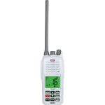
GME GX800W Handheld VHF Marine Radio – 5W/1W Switchable
GME GX800W Handheld VHF Marine Radio – 5W/1W Switchable – RRP $269
Marine safety in the palm of your hand
Built tough to withstand the harsh marine environment, GME’s GX800 handheld VHF radio delivers crystal clear communication in a flexible format.
Float and Flash – Waterproof to IP67, if this high performance radio is accidentally dropped overboard, it will not only float, but the LCD will flash brightly, ensuring easy location and retrieval.
5/1W Switchable Power – Reduce battery consumption by selecting the low power setting when using the radio at close range, ideal for communications between the mother ship and tender, or at full 5W power for communicating over longer distances.
Large, Bright LCD Screen – Clear and easy to read, even in difficult lighting conditions.
Programmable Scanning including Dual and Tri Watch – Program the way in which your GX800 scans channels to suit your activity. Dual and Tri Watch enable you to monitor a working or club channel while still being able to receive important broadcasts on Channel 16.
PRODUCT DETAILS
* Float and Flash
* Priority Scan
* Waterproof to IP67
* Dual and Tri Watch
* 5/1 watt Switchable Power
* All International, US and Canadian Marine VHF Channels
* Large, Bright LCD Screen
* Weather channels on US and Canadian bands
* Private Channel Facility
* Integrated Rechargable 1,700 mAh Lithium Polymer Battery
* Programmable Scan
* Warranty: Two YearSPECIFICATIONS:
GENERAL
* Frequency Range TX: 156.025 to 163.275 MHz
* Number of Channels: 56 International, 52 US, 59 Canadian, 10 Weather
* Channel Spacing: 25 kHz
* Battery Polarity: 7.4 V 1700 mAh Li-Polymer
* Operating Temperature: -20°C ~ +55°C
* Frequency stability ±: 5 PPM
* Modulation: FM
RECEIVER
* Spurious Response Immunity: ≥ 70 dB
* Conducted Spurious Emission: ≤ 70 dB
MECHANICAL SPECIFICATIONS
* Dimensions: 67 (W) x 153 (H) x 43 (D) mm
* Weight: 297 grams
COMPATABLE ACCESSORIES:
* BCV009 12V Vehicle Charger to suit GX800 (optional – please see related products)IN THE BOX:
* GX800 Handheld Marine VHF Radio
* Belt Clip
* 240V AC Charger
* Wrist Strap
* High Gain Flexible Antenna
* Instruction ManualSKU: GME GX800W VHF -
Marine Care
Boat Bling Hot Sauce – 990ml Spray Bottle
Boat Bling Hot Sauce – 990ml Spray Bottle
Ultimate Hard Water Spot Remover with High Gloss Wax Sealants
Sure, you can say you have tried it all, but once you try HOT Sauce, you’re old products will just begin to collect dust on your shelves. Hot Sauce out performs 2 and 3 step products with a simple spray and wipe.
Description:
* Bio-degradable, safe, soft water based detailer with specialty Polymer & Silicon waxes
* Removes hard water spots, mineral deposits and exhaust residue
* Will NOT strip your current wax, adds additional wax sealants with each use
* Designed for Fiberglass, Plastic, Chrome, Glass and all painted surfaces
* Spray on, wipe off Application
* Approved and Recommended by the Top Manufacturers in the Industry
* Use after each day on the water, follow up with Boat Bling Quickie Sauce every 3 monthsTech Tip:
Begin with 2 Micro Fiber towels – start in the rear of the boat where the spots and heat are the most extreme, spray 5-6 squirts on and wipe off, flipping the towel over as you go. Continue around the boat using the same towel until the you reach the front, then use a fresh micro fiber towel for the other side.How to Video:
SKU: Hot Sauce 990ml -
Uncategorised
Lowrance Hook-4 / Hook-4x / Elite 4 HDI/4x HDI/4 CHIRP/4x CHIRP Sun Cover (000-11307-001)
 Uncategorised
Lowrance Hook-4 / Hook-4x / Elite 4 HDI/4x HDI/4 CHIRP/4x CHIRP Sun Cover (000-11307-001)
Lowrance Hook-4 / Hook-4x / Elite 4 HDI/4x HDI/4 CHIRP/4x CHIRP Sun Cover (000-11307-001)
Suits only Lowrance Hook-4, Hook-4x, Elite 4 HDI & Elite 4 CHIRP Sounder/GPS Combos, and Lowrance Elite 4x HDI & Lowrance Elite 4x CHIRP Fishfinder/Sounders.
*Specifications from suppliers’ information.
SKU: 000-11307-001AU