Garmin 18mm Split Connector
Route cables in your vessel without drilling holes with this split connector (threaded, RJ45 cable).

Route cables in your vessel without drilling holes with this split connector (threaded, RJ45 cable).
| Weight | 0.02 kg |
|---|
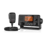
Stay in Contact on the Water
Communication is critical on the water. This easy-to-install fixed-mount VHF 215i radio enhances communication to help you stay in contact with the shore and other boats in your area.
Increase Your Peace of Mind
During an emergency situation, the 25-watt transmit power of VHF 215i gives fishermen, sailors and cruisers confidence at their fingertips.
Communicate Confidently on the Water
VHF 215i is easy to install and use and features a large, easy-to-read display. Just plug and play to compatible Garmin chartplotters and MFDs via the NMEA 2000 network. It provides standard Class D DSC functionality (distress calling and direct calling with user-programmed MMSI). The radio also includes frequency bands for all U.S., Canadian and international marine channels and 10 NOAA weather channels. VHF 215i is NMEA 0183 compatible, and its removable fist microphone can be relocated away from the radio. It’s compatible with the GHS 11 second-station handset.
Communicate with Style
Because your helm is a source of pride, the VHF 215i marine radio is designed to complement the appearance of GPSMAP® 7×2/9×2, 10×2/12×2, 7400/7600 series chartplotters and GPSMAP 8400/8600 series MFDs.
Specs
In the Box
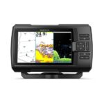
See fish and structure in maximum detail when you pick your display colour, your location and your sonar for your day on the water with the STRIKER Vivid 7cv fishfinder with transducer.
![]()
The sonar colour you pick says a lot about your fishing style. Good thing there are 7 new vivid options.
![]()
What a view. Use the included transducer to get CHIRP traditional and ClearVü sonars.
![]()
Never lose a hot spot again. Use waypoint marking to find your way back.
![]()
What’s under the water’s surface looks pretty good as 1-foot contours, just saying.
![]()
Wi-Fi® connection1 on land opens up a world of possibilities on the water.
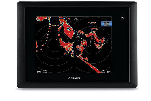
This 24-inch high-definition radar dome pairs ease of use with advanced features typically found on open arrays for enhanced situational awareness.
![]()
This 24-inch radar dome is easy to use and has options to make installation simple. What could be better?
![]()
It packs the power and echo definition you need, at all ranges.
![]()
When weather and sea conditions shift, the gain and sea filter do too — automatically.
![]()
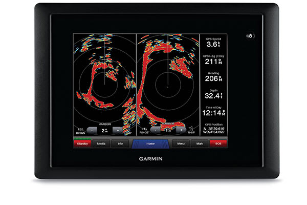
See what’s close and far away with dual-range operation.

This 24-inch dome radar delivers 4-kW transmit power and clear echo definition at all ranges. It has a maximum range of 48 nautical miles (88 km) and 48- or 24-RPM rotation speeds for fast screen refreshes.
GMR™ 24 xHD features 8-bit true colour high resolution for outstanding target separation with less screen clutter on your chartplotter.
This radar doesn’t have any complex user settings to deal with, so it’s easy to install and start using.
Gain levels automatically adjust to optimum settings for harbours, near shore and offshore in open waters.
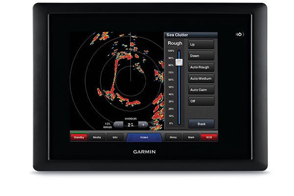
Gain automatically adjusts sea clutter for calm, medium and rough sea conditions.
This feature enables the fully independent split-screen display of far and close radar views.
You have the option to protect areas behind the radar from being radiated while providing full forward-looking radar capability. This also makes installation more flexible.
Overlay radar images onto your chartplotter’s map page. You can add an optional autopilot or heading sensor (sold separately) for best results.
GMR™ 24 xHD provides MARPA target tracking when combined with a multifunction display and heading sensor (sold separately).
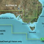
Garmin BlueChart g2 Vision – Southern Australia [Garmin Part Number: 010-C0753-00] – RRP $399
Get a fresh perspective when you take to the water with BlueChart® g2 Vision®. With BlueChart g2 Vision data, you’ll get detailed marine cartography that provides convenient viewing of nautical content and other premium features. BlueChart g2 Vision allows you to see your vessel’s precise, on-chart position in relation to naviads, coastal features, anchorages, obstructions, waterways, restricted areas and more. You will also have access to detailed mapping capabilities that include Safety Shading, Fishing Charts, smooth data transition between zoom levels, harmonious transition across chart borders, and reduction of chart discontinuities. Premium features include 3-D perspective above and below the waterline, Auto Guidance, high-resolution imagery, and “real picture” aerial photos of ports, harbours, marinas, waterways, landmarks and other points of interest. It’s the most realistic mapping display Garmin has ever offered.
Detailed coverage of the Southern coast of Australia from Geraldton to Brisbane (VPC020R). Also includes detailed coverage of Perth, the Great Australian Bight, Adelaide, Melbourne, Tasmania, Sydney, and Norfolk Island. (if another region is required please contact us for availability).
THIS IS SUITABLE FOR CURRENT MODEL GARMIN GPSMAP 7407xsv, GPSMAP 7408xsv, GPSMAP 7410xsv, GPSMAP 7412xsv, echoMAP 75dv, echoMAP 75sv & echoMAP 95sv SOUNDER/GPS COMBO UNITS, PLEASE SEE RELATED PRODUCTS OR ASK FOR FURTHER INFORMATION.
WARRANTY:
We are an authorised Australian Garmin retailer, as such Full Australian Manufacturers Warranty is applicable for this item. Please note if a Garmin unit is purchased overseas or from a non-authorised Garmin retailer you may not receive warranty coverage in Australia.
*Specifications from suppliers’ information. Actual depth capabilities depend on transducer installation, bottom type & water conditions. All sonars typically read deeper in freshwater than in saltwater. Images for display purposes only.