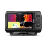
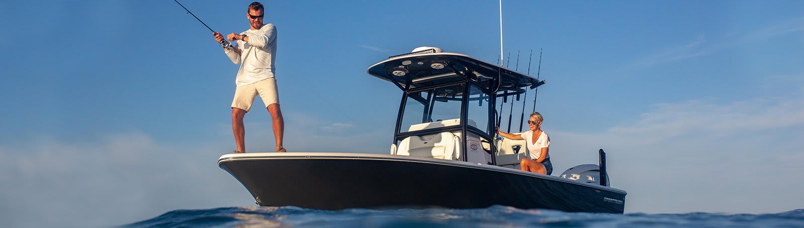
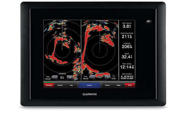
Garmin GPSMAP 753xsv – Chartplotter with SideVü, ClearVü and Traditional CHIRP Sonar with Garmin Navionics+ Mapping
Price Match
$1,799.00 $1,999.00
-
Garmin, Garmin Chartplotters, Sanctuary Cove
Garmin GPSMAP 753xsv – Chartplotter with SideVü, ClearVü and Traditional CHIRP Sonar with Garmin Navionics+ Mapping
-10% Garmin, Garmin Chartplotters, Sanctuary Cove
Garmin GPSMAP 753xsv – Chartplotter with SideVü, ClearVü and Traditional CHIRP Sonar with Garmin Navionics+ Mapping
Garmin GPSMAP 753xsv – GET A SHARPER VIEW FROM YOUR CONNECTED HELM
With its sleek design, powerful processing and upgraded IPS display, this advanced 7″ chartplotter integrates seamlessly into your Garmin marine system.

Easily integrate with more engines.

Connect to compatible third-party devices with OneHelm™ digital switching.

Easily build your marine system using the best network connectivity.

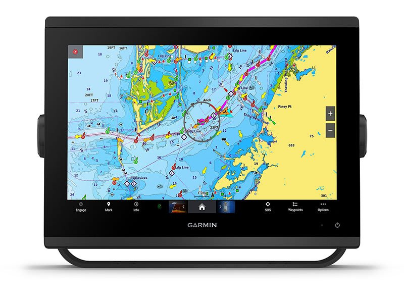
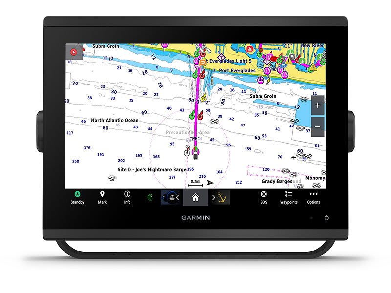
Compatible with premium maps and charts1 for the best in Garmin navigation.

See below your boat with built-in sonar capabilities

Manage your marine experience from nearly anywhere1.
SKU: 010-02365-62 -
Garmin, Garmin Accessories, Sanctuary Cove
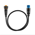
Garmin 8-pin Transducer to 12-pin Sounder Adapter Cable with XID
 Garmin, Garmin Accessories, Sanctuary Cove
Garmin 8-pin Transducer to 12-pin Sounder Adapter Cable with XID
Garmin 8-pin Transducer to 12-pin Sounder Adapter Cable with XID
Use this adapter cable to connect an 8-pin transducer with XID to a 12-pin sonar port on a compatible marine device.
SKU: 010-12122-10
Garmin GPSMAP 753xsv – GET A SHARPER VIEW FROM YOUR CONNECTED HELM
With its sleek design, powerful processing and upgraded IPS display, this advanced 7″ chartplotter integrates seamlessly into your Garmin marine system.
![]()
Easily integrate with more engines.
![]()
Connect to compatible third-party devices with OneHelm™ digital switching.
![]()
Easily build your marine system using the best network connectivity.
![]()
Compatible with premium maps and charts1 for the best in Garmin navigation.
![]()
See below your boat with built-in sonar capabilities.
![]()
Manage your marine experience from nearly anywhere1.
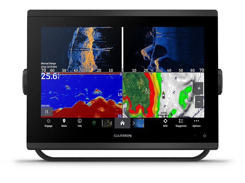
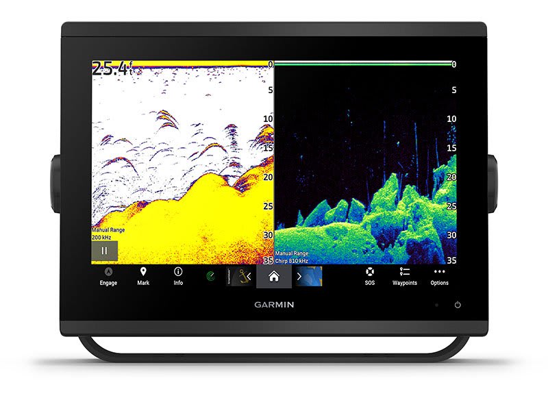
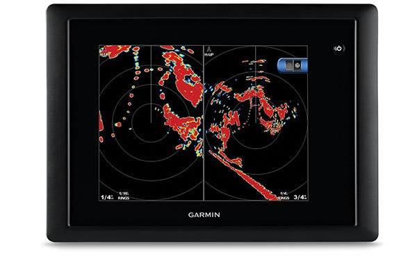
See the world below.
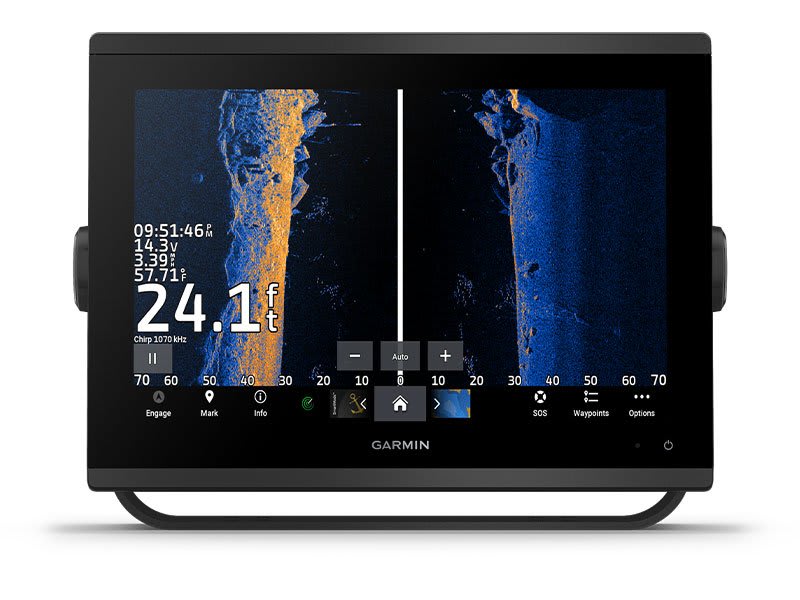
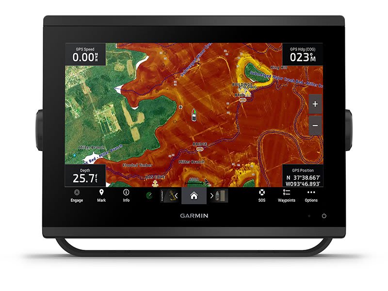
ULTRA HIGH-DEFINITION SCANNING SONAR
Get built-in Ultra High-Definition SideVü and ClearVü scanning sonars with vivid, high-contrast color palettes to help distinguish fish from structure. GPSMAP® X3 series also supports 1 kW CHIRP traditional sonar capabilities. Built-in sonar compatibility only available on xsv models.
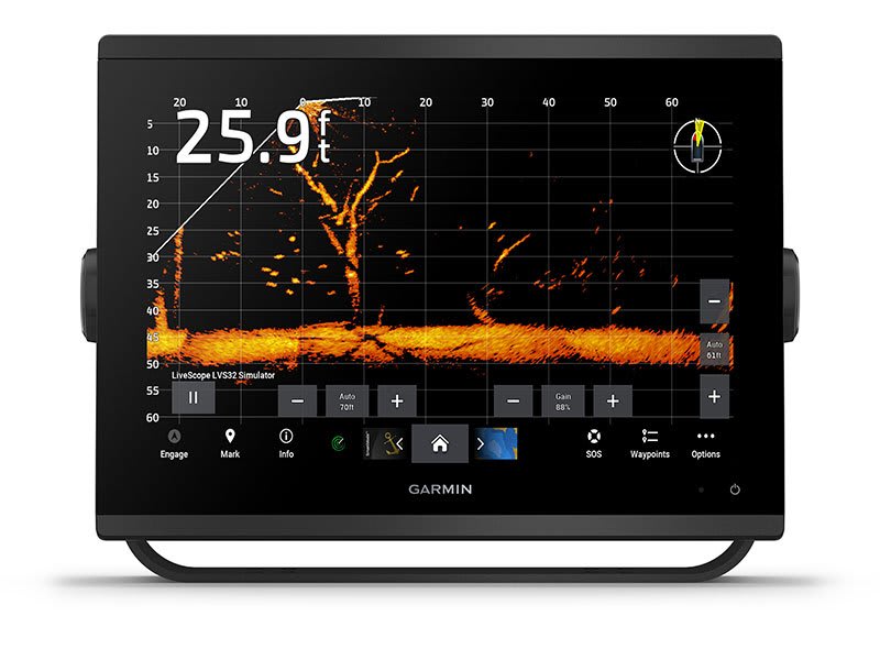
PANOPTIX™ & LIVESCOPE™ SONAR SUPPORT
Pair with Panoptix or LiveScope™ easy-to-interpret live sonar (transducer required, sold separately) to see all around your boat in real time.
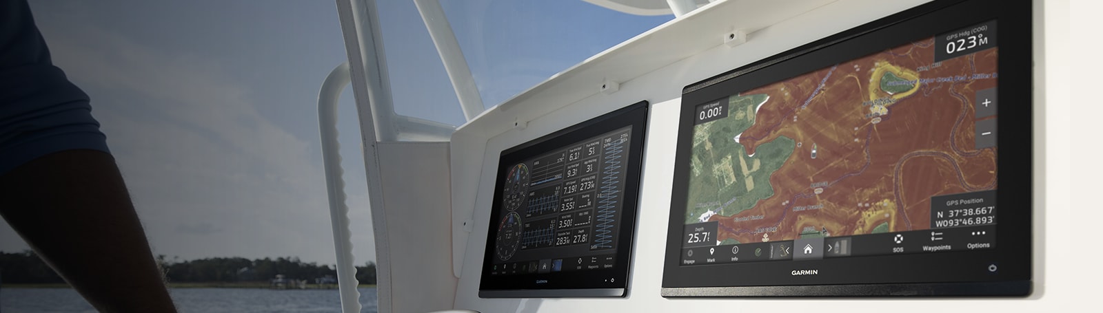
Made for your helm.
FASTER, SHARPER, SMARTER
With its added processing power and new slimline design featuring edge-to-edge glass and a smaller unit footprint, it’s easy to retrofit this plotter in a wider range of dash configurations.
IMPROVED DISPLAY OPTICS
New higher-resolution IPS displays for 9″ and 12″ plotters offer improved sunlight readability and visibility from any angle, with 50% more pixels than previous-generation 9″ GPSMAP devices.
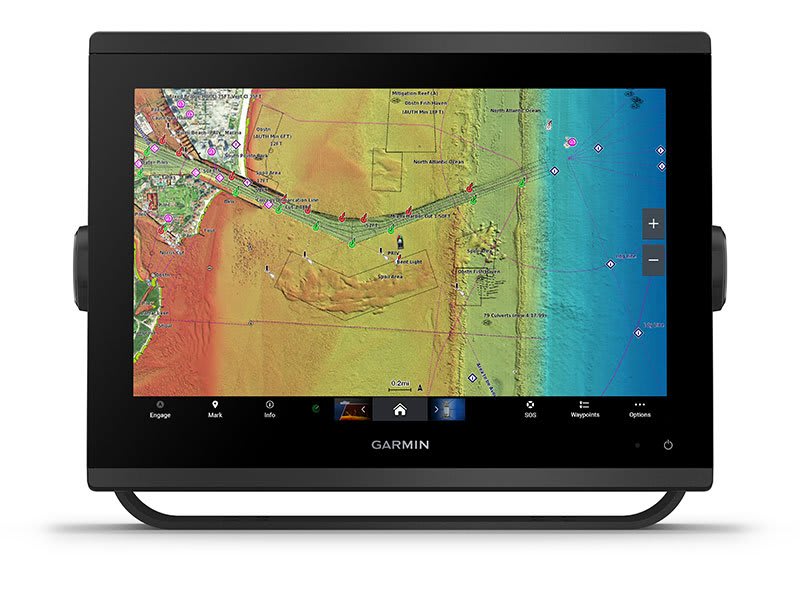
CHARTS AND MAPS
Bring a fresh new look and feel to your chartplotter with optional Garmin Navionics+™ or premium Garmin Navionics Vision+™ cartography featuring integrated coastal/inland content, access to daily updates, Auto Guidance+™ technology3 and more.
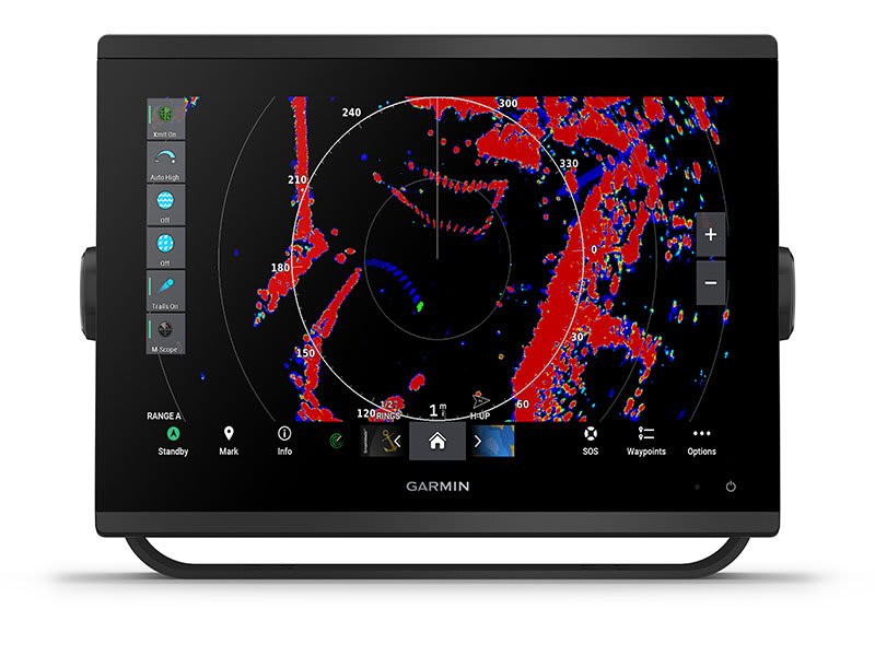
OPTIONAL RADAR BUNDLE
To help you avoid weather and traffic on the water, the compact 4 kW GMR™ 18 HD+ dome radar is available as a bundled option with your GPSMAP chartplotter/sonar package.

Sail and navigate with ease.
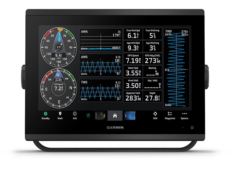
GARMIN SAILASSIST™ SAILING FEATURES
View laylines, race start line guidance, enhanced wind rose, heading and course-over-ground lines, true wind data fields and tide/current/time slider, wind angle, set and drift, wind speed and more.
OPTIONAL PREMIUM NAVIGATION FEATURES
These optional charts offer the best of Garmin and Navionics® data, Auto Guidance3 technology and other premium navigation features.
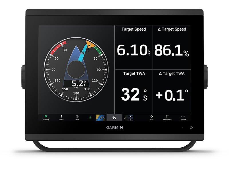
SAILING POLARS
Use the polar table to see key data, including how fast you should go at a certain wind angle and speed — so you know whether you need to adjust sail trim.
GARMIN MARINE NETWORK
If you have multiple compatible Garmin devices on your boat, you can share information — such as maps, user data, radar and IP camera video — among them.
NMEA 2000® AND NMEA 0183 NETWORKS
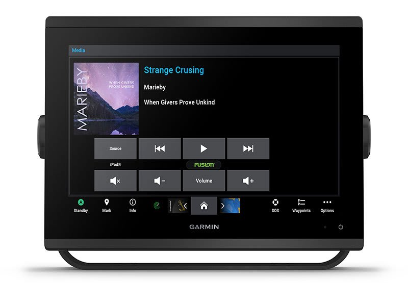
Connect to compatible autopilots, digital switching, weather, Fusion-Link™ audio system, media, VHF, AIS and more from one screen.
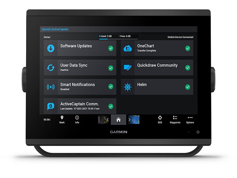
ACTIVECAPTAIN® APP
Built-in Wi-Fi® connectivity pairs with the free all-in-one mobile app for access to the OneChart™ feature, smart notifications, software updates, Garmin Helm™ digital switching, Garmin Quickdraw™ Community 4.
INTEGRATED ANT® TECHNOLOGY
Connect with some of your favourite devices, such as quatix® marine watches, gWind™ Wireless 2 transducers , GNX™ Wind marine instruments and wireless remote controls.
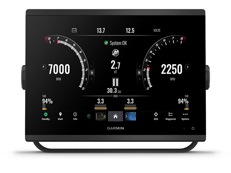
ENGINE CONNECTIVITY
Now you can connect your chartplotter to different kinds of engines, including select Yamaha engines.
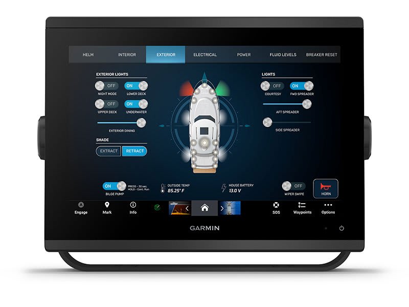
ONEHELM FEATURE
This feature brings together all the operations and capabilities of select third-party devices, such as EmpirBus™ digital switching, on one screen.
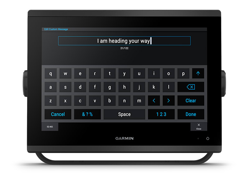
SEND INREACH® DEVICE MESSAGES
Pair your inReach satellite communicator5 to your chartplotter, and type custom messages using your MFD’s on-screen keyboard. Access your contact list or enter an email, inReach address or phone number. You can also group messages by conversation for a texting-like experience.
What’s in the box?
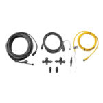
- GPSMAP 753xsv chartplotter
- microSD™ card preinstalled
- Power cable
- NMEA 2000® T-connector
- NMEA 2000 drop cable (2 meters)
- 8-pin transducer to 12-pin sounder adapter cable
- Bail mount kit with knobs
- Flush mount kit with gasket
- Protective cover
- Trim piece snap covers
- Documentation
View Installation Instructions
View Owner’s Manual
| Weight | 1.3 kg |
|---|
General |
|
| DIMENSION | 7.6″ x 5.5″ x 2.9″ (19.2 x 14.0 x 7.4 cm) |
| WEIGHT |
2.8 lbs (1.3 kg) |
| WATERPROOF |
IPX7 |
| TOUCHSCREEN | ✔ |
| DISPLAY TYPE | WSVGA |
| DISPLAY SIZE | 6.1″ x 3.5″; 7.0″ diagonal (15.4 x 9.1 cm; 17.8 cm diagonal) |
| DISPLAY RESOLUTION | 1024 x 600 pixels |
| MOUNTING OPTIONS | Bail, flush or flat (Garmin does not offer any hardware or accessories for a flat-mount installation. Professional tools and knowledge is required.) |
| INPUT | Touchscreen |
Maps & Memory |
|
| ACCEPTS DATA CARDS |
2 microSD cards (back of unit) |
| WAYPOINTS |
5000 |
| TRACK POINTS | 50,000 |
| TRACKS | 50 saved tracks |
| NAVIGATION ROUTES | 100 |
Sensors |
|
| GPS | ✔ |
| GLONASS | ✔ |
| GALILEO | ✔ |
| HAS BUILT-IN RECEIVER | ✔ |
| RECEIVER |
10 Hz |
| NMEA 2000 COMPATIBLE | ✔ |
| NMEA 0183 COMPATIBLE | ✔ |
| SUPPORTS WAAS | ✔ |
Built-in maps |
|
| BUILT-IN AUTO GUIDANCE+ | ✔ |
| GARMIN NAVIONICS+ INLAND & COASTAL | ✔ |
| TIDE TABLES | ✔ |
Optional map support |
|
| GARMIN NAVIONICS+™ | ✔ |
| GARMIN NAVIONICS VISION+™ | ✔ |
| TOPO | ✔ |
| STANDARD MAPPING | ✔ |
| GARMIN QUICKDRAW CONTOURS | ✔ |
| RASTER CHART SUPPORT | ✔ |
Chartplotter Features |
|
| SMART MODE COMPATIBLE | ✔ |
| AIS | ✔ |
| DSC | ✔ |
| SUPPORTS FUSION-LINK™ COMPATIBLE RADIOS | ✔ |
| GSD BLACK BOX SONAR SUPPORT | ✔ |
| GCV BLACK BOX SONAR SUPPORT | ✔ |
| ACTIVECAPTAIN MOBILE PLANNING COMPATIBLE | ✔ |
| GRID (GARMIN REMOTE INPUT DEVICE) COMPATIBLE | ✔ |
| WIRELESS REMOTE COMPATIBLE | ✔ |
| SAILING FEATURES | ✔ |
| SPOKEN AUDIO ALERTS | ✔ |
| ONEHELM SUPPORT | ✔ |
Electrical features |
|
| POWER INPUT | 10 to 32 Vdc |
| TYPICAL CURRENT DRAW AT 12 VDC | 1.18 A |
| MAXIMUM CURRENT DRAW AT 12 VDC | 2.96 A |
| MAXIMUM POWER USAGE AT 10 VDC | 35.9W |
Sonar Features & Specifications |
|
| DISPLAYS SONAR | ✔ |
| POWER OUTPUT | 1 kW |
| TRADITIONAL SONAR (DUAL FREQUENCY/BEAM) | built-in (single channel CHIRP, 70/83/200 kHz, L, M, H CHIRP) |
| CLEARVÜ | Built-in 260/455/800/1000/1200 kHz |
| SIDEVÜ | Built-in 260/455/800/1000/1200 kHz |
| PANOPTIX™ SONAR | ✔ |
| LIVESCOPE | ✔ |
Connections |
|
| NMEA 2000® PORTS | 1 |
| CONNECTIONS NMEA0183 INPUT PORTS | 1 |
| NMEA 0183 INPUT (TX) PORTS | 1 |
| VIDEO INPUT PORTS |
1 (BNC composite) |
| J1939 PORTS | 1 |
| GARMIN MARINE NETWORK PORTS |
1 |
| 12-PIN TRANSDUCER PORTS | 1 |
| USB PORTS | ✔ |
| BNC EXTERNAL GPS ANTENNA PORT | ✔ |
| BLUETOOTH® PAIRING | ✔ |
| ANT+ (CONNECTIVITY) | ✔ |
| GARMIN WI-FI NETWORK (LOCAL CONNECTION) | ✔ |
You may also like…
-
Garmin, Garmin Accessories
Garmin GND™ 10 Black Box Bridge
Garmin GND™ 10 Black Box Bridge
- Converts data between the Nexus network and NMEA 2000®
- Provides compatibility between Nexus and Garmin products
- Simple plug-and-play installation between Nexus, NMEA 2000 and USB
- No user setup or system configuration required
- Allows PC applications, such as NexusRace™, Expedition, Adrena or SeaTrack, to communicate sailing-specific functions between Nexus and NMEA 2000 networks
The GND 10 black box bridge seamlessly integrates Nexus instruments and sensors with the Garmin family. It converts data between the Nexus Network and NMEA 2000 to provide compatibility between Nexus and Garmin products, including gWind™ and gWind™ Race transducers. Simple plug-and-play installation between Nexus and NMEA 2000, with USB connectivity, eliminates the need for user setup and system configuration.
GND 10 allows PC applications, such as NexusRace, Expedition, Adrena or SeaTrack, to communicate sailing-specific functions between Nexus and NMEA 2000 networks. It also enables GND 10 software updates over NMEA 2000. Existing NexusRace PC application can be used to update software, configure and calibrate Nexus devices over USB using the FDX protocol.
SKU: 010-01226-00 -
Garmin, Garmin Accessories, Sanctuary Cove
Garmin NMEA 2000 Starter Kit
Garmin NMEA 2000 Starter Kit
Our starter kit has everything you need to build a basic NMEA 2000 network on your boat. The kit includes an NMEA 2000 drop cable (2 m), backbone cable (6 m), power cable (2 m), 2 T-connectors, and male and female terminator connectors.
SKU: 010-11442-00 -
Garmin, Garmin Accessories, Sanctuary Cove
Garmin GPS 24xd NMEA 2000 – White
Garmin GPS 24xd NMEA 2000 – EXPLORE COASTAL WATERS
The GPS 24xd position receiver and antenna gives you precise location with multi-band GNSS and heading accuracy even at slow speeds.

Navigate in more locations with expanded GNSS support.

Get high-sensitivity tracking with fast GPS update rate.

Accurately pinpoint your heading — regardless of speed.

It’s water-resistant (IPX7) to withstand the elements.

Install it easily with multiple mounting options.

The antenna is compatible with NMEA 2000® devices.

More accurate data — for more confident navigation.
MULTI-BAND GNSS
Multi-band GNSS provides precise location accuracy1 to within 1 metre to compatible marine multifunction displays, instrument displays and autopilots.
MAGNETIC HEADING
The magnetic heading sensor provides accuracy to within 3 degrees, stabilising charts, radar overlay and MARPA even at slow speeds.
HIGH-SENSITIVITY GPS
Fast 10 Hz position update rates provide high-sensitivity position, velocity and time data.
EXPANDED GNSS SUPPORT
GPS 24xd provides access to four key global navigation satellite systems (GPS, Galileo2, GLONASS and BeiDou2) to more accurately track in challenging conditions than GPS alone.
MULTI-SBAS COMPATIBLE
Multi-SBAS compatibility corrects signal measurement errors and provides information about the accuracy, integrity, continuity and availability of its signals.
MOUNTING OPTIONS
Installation is easy with under-deck, pole and surface-mount options.
11 < 1 metre CEP, < 3 metres 95%2Supported when available What’s in the box?
- GPS 24xd NMEA 2000®
- Pole mount
- Surface mount
- Under-deck mount
- NMEA 2000 backbone/drop cable (6 metres)
- NMEA 2000 T-connector
- Documentation
Installation Instructions
Setting Up A NMEA Network and Installing a Garmin GPS 24XD on a boat
SKU: 010-02316-10
Related products
-
Garmin, Garmin Trolling Motors, Sanctuary Cove
Garmin Force® 57″ Trolling Motor
Garmin Force® 57″ Trolling Motor – FISH WITH FORCE
Get on fish faster, and stay on the water with the most powerful, most efficient trolling motor available1 — and it’s quiet, too.

Force is more efficient at 24 V than the competition’s 36 V system. No lie.

Wirelessly connect to your Garmin chartplotter, and open up a world of possibilities.
It comes with sonar built in, too? That’s just too good to be true.

All the control of a cable-steered pedal without the cable.

Just point the handheld remote where you want to go, and Force will take you there.
SKU: 010-02025-00 -
Garmin, Garmin Fishfinder, Sanctuary Cove
Garmin STRIKER Vivid 7sv with GT52HW-TM Transducer
Garmin STRIKER Vivid 7sv With GT52HW-TM Transducer – THE CHOICE IS YOURS
See fish and structure in maximum detail when you pick your display colour, your location and your sonar for your day on the water with the STRIKER Vivid 7sv fishfinder with transducer.

The sonar colour you pick says a lot about your fishing style. Good thing there are 7 new vivid options.

What a view. Use the included transducer to get CHIRP traditional and ClearVü sonars.

Never lose a hot spot again. Use waypoint marking to find your way back.
What’s under the water’s surface looks pretty good as 1-foot contours, just saying.
Wi-Fi® connection1 on land opens up a world of possibilities on the water.
SKU: 010-02553-01 -
Garmin, Garmin Radars
Garmin Dome Radar GMR 18 xHD – 4kW 18”
Garmin Dome Radar GMR 18 xHD – 4kW 18” – COMPACT, HIGH-DEFINITION RADAR DOME
This 18-inch high-definition radar dome pairs ease of use with advanced features typically found on open arrays for enhanced situational awareness.

If your boat has limited space for radar placement, this compact dome is for you.
It packs the power and echo definition you need, at all ranges.

When weather and sea conditions shift, the gain and sea filter do too — automatically.

See what’s close and far away with dual-range operation.

Know what’s out there.
COMPACT AND POWERFUL
This 18-inch dome radar delivers 4-kW transmit power and clear echo definition at all ranges. It has a maximum range of 48 nautical miles (88 km) and 48- or 24-RPM rotation speeds for fast screen refreshes.
HIGH-RESOLUTION RADAR
GMR™ 18 xHD features 8-bit true colour high resolution for outstanding target separation with less screen clutter on your chartplotter.
INTUITIVE OPERATION
This radar doesn’t have any complex user settings to deal with, so it’s easy to install and start using.
Performance in all conditions.
DYNAMIC AUTO GAIN
Gain levels automatically adjust to optimum settings for harbours, near shore and offshore in open waters.
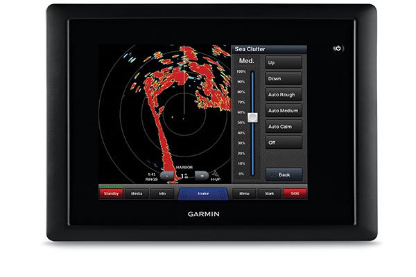
DYNAMIC SEA FILTER
Gain automatically adjusts sea clutter for calm, medium and rough sea conditions.
DUAL-RANGE OPERATION
This feature enables the fully independent split-screen display of far and close radar views.
NO TRANSMIT ZONE
You have the option to protect areas behind the radar from being radiated while providing full forward-looking radar capability. This also makes installation more flexible.
RADAR OVERLAY
Overlay radar images onto your chartplotter’s map page. You can add an optional autopilot or heading sensor (sold separately) for best results.
MARPA TARGET TRACKING
GMR™ 18 xHD provides MARPA target tracking when combined with a multifunction display and heading sensor (sold separately).
In the box
- GMR 18 xHD
- Mounting hardware kit
- Power cable (15 m/49.21 ft)
- Network cable (15 m/49.21 ft)
- Installation instructions
- Mounting template
- Grommet for marine cable
Installation Instructions
Garmin GMR 18xHD & 24 xHD
SKU: 010-00959-00 -
Garmin, Garmin Sonar & Transducers, Marine Electronics, Transducers
Garmin GT54UHD-TM Transducer – Ultra High-Definition Scanning Sonar All-in-one Transducer
-8% Garmin, Garmin Sonar & Transducers, Marine Electronics, Transducers
Garmin GT54UHD-TM Transducer – Ultra High-Definition Scanning Sonar All-in-one Transducer
Garmin GT54UHD-TM Transducer – Ultra High-Definition Scanning Sonar All-in-one Transducer
All-in-one Transducer
- One transducer provides the highest resolution ClearVü and SideVü scanning sonar images available and amazingly clear high wide CHIRP traditional sonar
- High wide CHIRP traditional sonar provides remarkably clear target separation and definition
- See incredibly detailed images of fish and structure up to 200’ below your boat with 800 kHz ClearVü sonar
- Two SideVü sonar frequency settings (455/1200 kHz) provide options for extended range of up to 500’
- Easy-to-install, compact, all-in-one design includes transom and trolling motor mounts
Ultra-high Clarity
The GT54UHD-TM transducer provides image details so clear and precise, you can actually see fish hanging just off branches of submerged trees, brush and rocks. You can see size differences between bigger and smaller fish and even see individual fish swimming in bait balls. You get the highest resolution ClearVü and SideVü scanning sonar images available plus amazingly clear high wide CHIRP traditional sonar1 — all in one transducer.
Ultra-high Performance
Ultra High-Definition scanning sonar provides extended range and depth performance. It shows you incredibly detailed images of fish and structure up to 200’ below your boat with 800 kHz ClearVü, while two SideVü sonar frequency settings (455/1200 kHz) provide options for extended range of up to 500’. It’s easy to install with included transom and trolling motor mounts so you can start fishing faster.
¹For use with GPSMAP® 8400xsv/8600xsv chartplotter/sonar combos
SKU: 010-12909-000