C-MAP® Reveal charts help anglers and divers save time on the water, finding key areas faster with the high-definition views of structure, wrecks and contour changes on the sea floor. The high-detail C-MAP® Reveal imagery replaces shaded relief data in selected areas with more accurate depth variations, revealing the best fishing and diving spots. C-MAP Reveal charts include C-MAP HRB Coastal Data, Genesis social map data and satellite imagery that can be overlaid on top of the standard vector charts used for navigation.
Key Features
- High-definition C-MAP Reveal layer of the sea bottom on selected areas
- Reduces search time with immediate display of bottom structure, wrecks, isolated reefs and ledges
- Easy to use – just turn on Shaded Relief setting in chartplotter
- C-MAP Reveal charts contain full C-MAP MAX-N+ vector navigation data, including new features like High Resolution Bathy, Custom Depth Shading, Genesis layer and satellite imagery
- Includes detailed marina and port plans
- Most affordable sea bottom charts available
| Weight | 0.1 kg |
|---|
Related products
-
Misc Parts, Trailer Parts
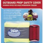
Ark – Outboard Prop Safety Cover with LED Light for Night Visibility (PC400B)
 Misc Parts, Trailer Parts
Ark – Outboard Prop Safety Cover with LED Light for Night Visibility (PC400B)
Ark – Outboard Prop Safety Cover with LED Light for Night Visibility (PC400B)
Aids visibility for drivers and pedestrians. Warning LED lamp for night visibility. Fluorescent fabric with reflector stripe fits most outboard propellers securely. Measures 400mm x 400mm.SKU: PC400B -
Seating, Seats
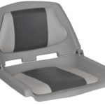
Oceansouth Fisherman Boat Seat – Grey/Charcoal
ceansouth Fisherman Boat Seat – Grey/Charcoal
* This product due to its bulky nature requires an additional freight surcharge. We will contact you regarding this depending on location – or simply contact us on 0732658016 for a quote.
- Marine-Grade Polymer Construction: Built to withstand harsh marine environments, ensuring long-term durability.
- Thick Moulded Foam Seat and Back Cushions: Offers superior comfort for extended periods of sitting.
- UV-Resistant OMNOVA Fabric: Helps maintain the seat’s vibrant colour even after prolonged sun exposure.
- Aluminum Powder-Coated Hinges: Provides enhanced stability and durability.
- Heavy-Duty Moulded Plastic Inner Frame: Ensures reliable performance and longevity.
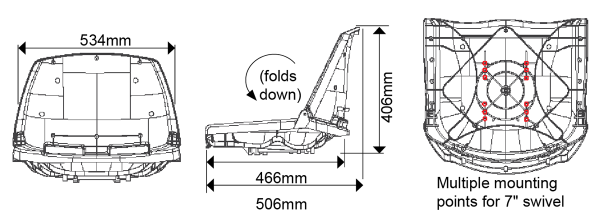
- Versatile Compatibility: Fits all standard 7” swivel bases, Oceansouth pedestals and Oceansouth Titan Removeable Swivels.
- Multiple colours to choose from
With dimensions of 40cm in height, 53cm in width, and 50cm in depth and a seat depth of 46cm, the Oceansouth Fisherman Boat Seat combines functionality and style to enhance your boating experience.
 SKU: MA 702-23
 -
Uncategorised
Lowrance Hook-4 / Hook-4x / Elite 4 HDI/4x HDI/4 CHIRP/4x CHIRP Sun Cover (000-11307-001)
 Uncategorised
Lowrance Hook-4 / Hook-4x / Elite 4 HDI/4x HDI/4 CHIRP/4x CHIRP Sun Cover (000-11307-001)
Lowrance Hook-4 / Hook-4x / Elite 4 HDI/4x HDI/4 CHIRP/4x CHIRP Sun Cover (000-11307-001)
Suits only Lowrance Hook-4, Hook-4x, Elite 4 HDI & Elite 4 CHIRP Sounder/GPS Combos, and Lowrance Elite 4x HDI & Lowrance Elite 4x CHIRP Fishfinder/Sounders.
*Specifications from suppliers’ information.
SKU: 000-11307-001AU