Shop
Showing 1111–1140 of 3735 results
-
EOFY, Garmin, Garmin Chartplotters, Marine Electronics, Sanctuary Cove, Sounders
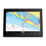
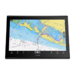
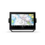
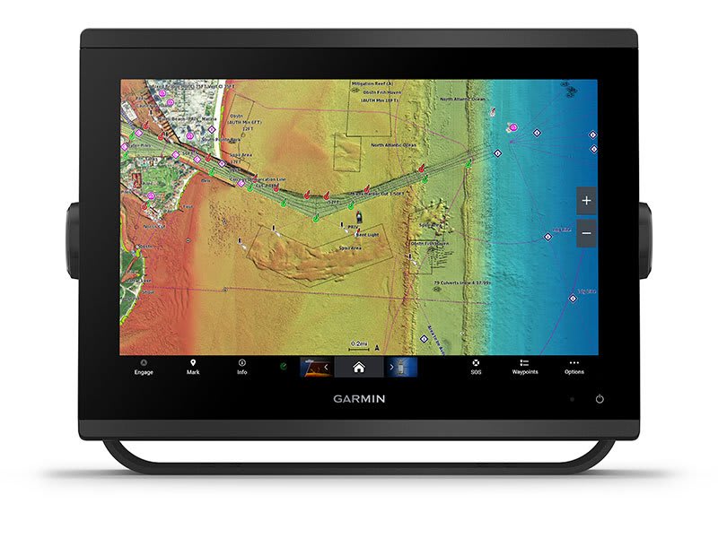
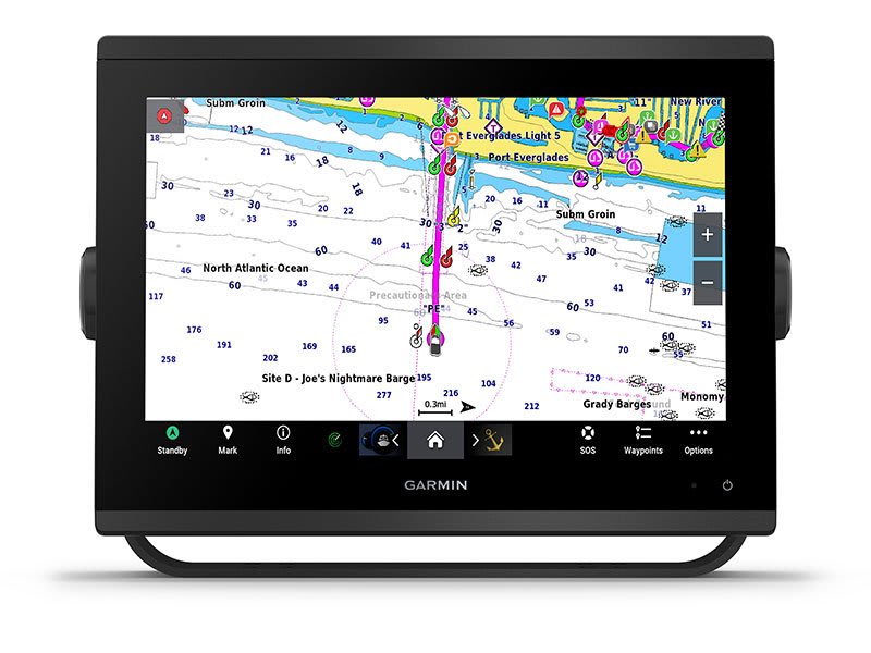
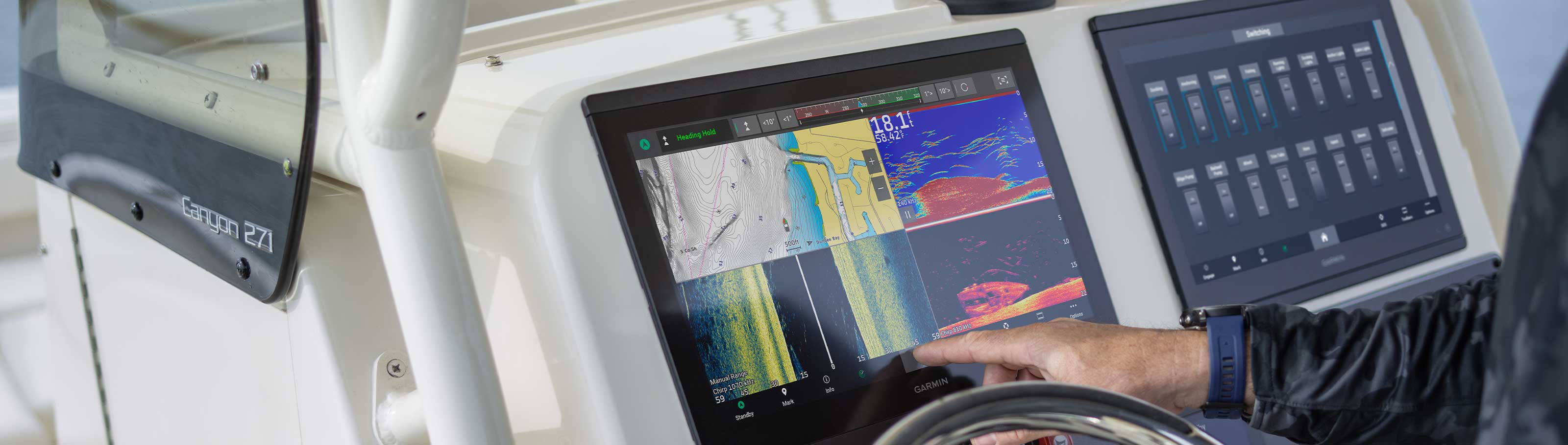
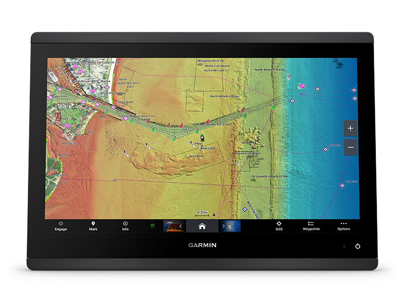
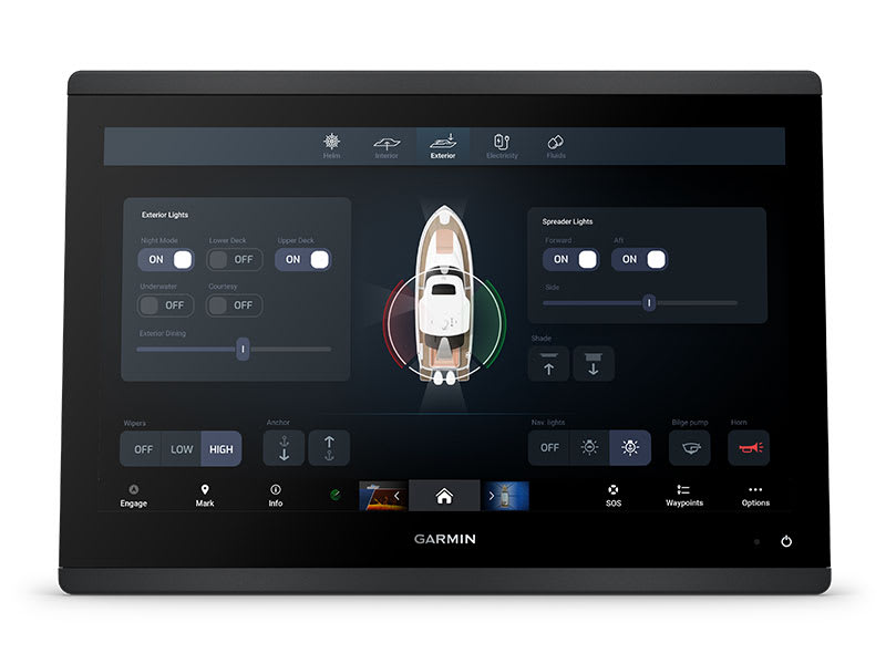
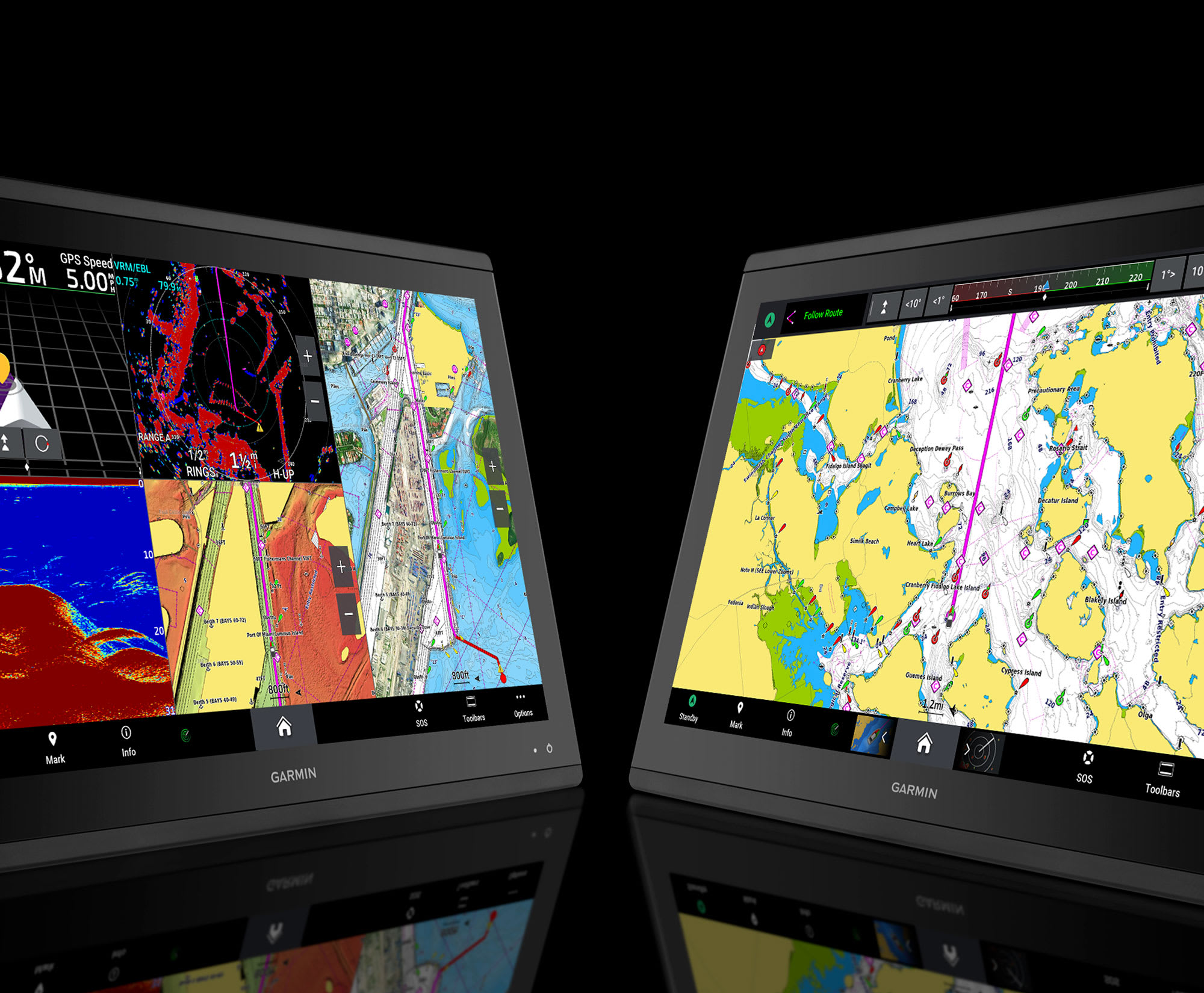
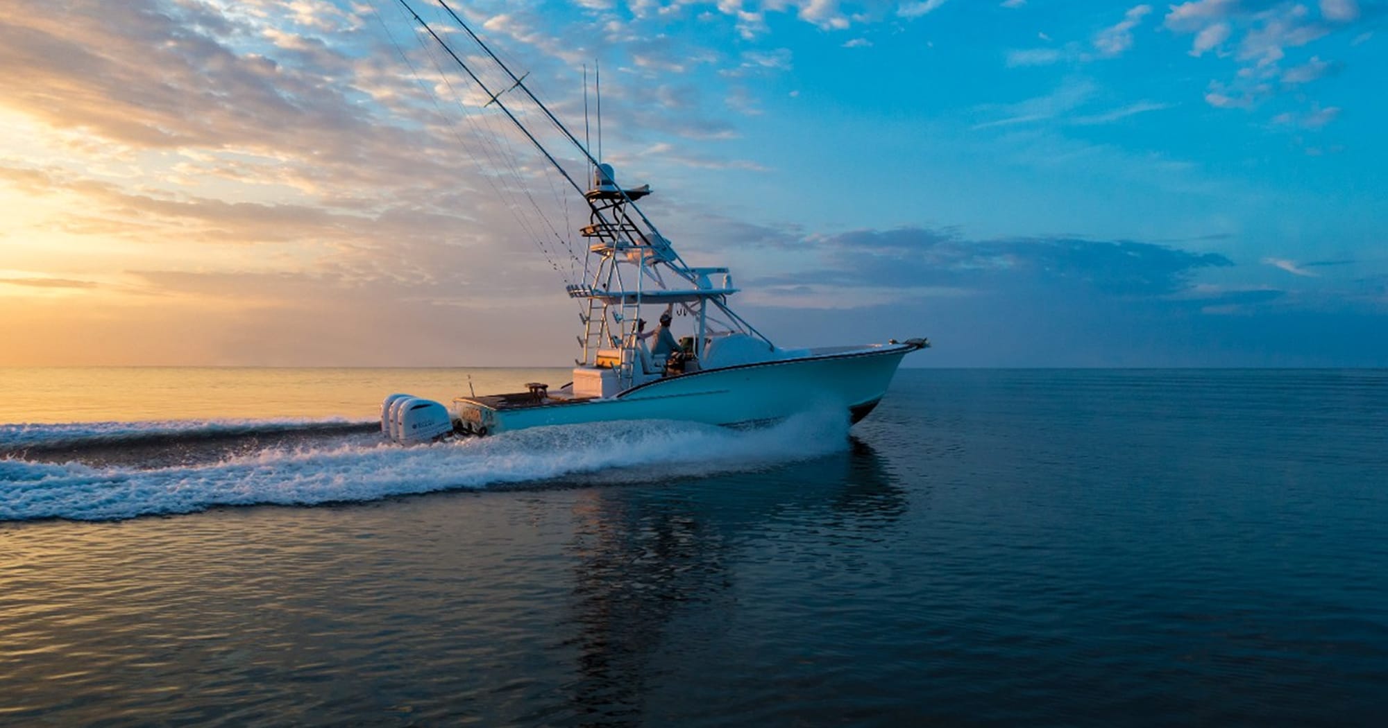
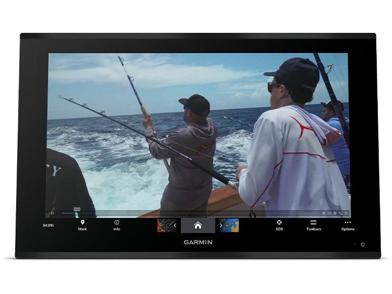
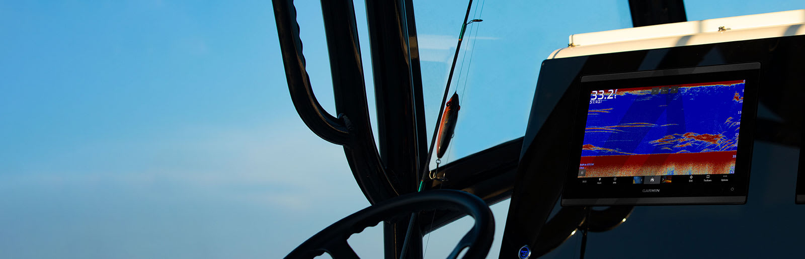
Garmin GPSMAP 1253xsv
-10%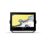 EOFY, Garmin, Garmin Chartplotters, Marine Electronics, Sanctuary Cove, Sounders
Garmin GPSMAP 1253xsv
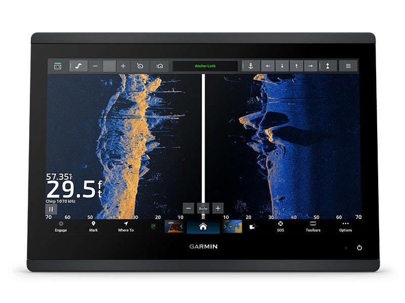
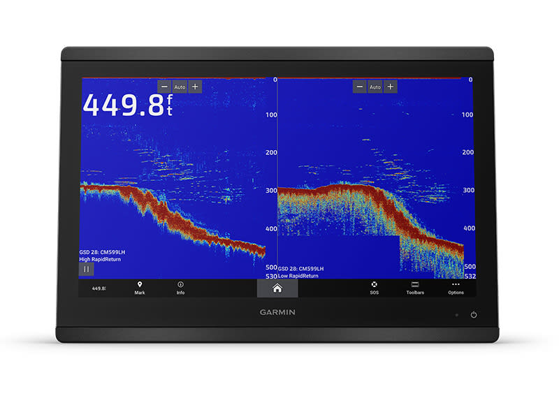
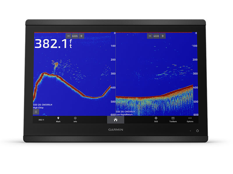
Garmin GPSMAP 1253xsv – GET A SHARPER VIEW FROM YOUR CONNECTED HELM
With its sleek design, powerful processing and upgraded IPS display, this advanced 12″ chartplotter integrates seamlessly into your Garmin marine system.
 Easily integrate with more engines.
 Connect to compatible third-party devices with OneHelm™ digital switching.
 Easily build your marine system using the best of network connectivity.
 Compatible with premium maps and charts1 for the best in Garmin navigation.
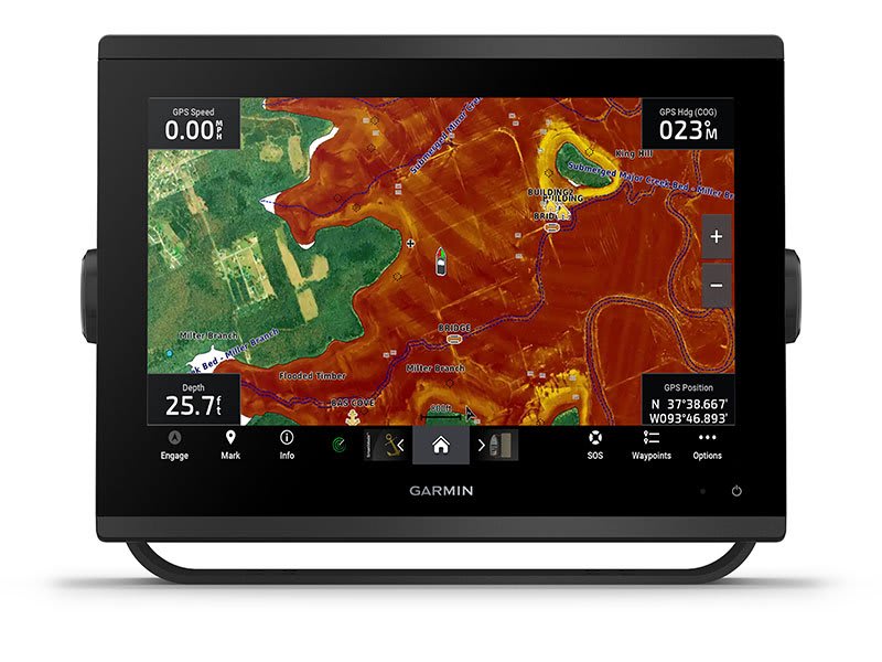
 See below your boat with built-in sonar capabilities
 Manage your marine experience from nearly anywhere1.
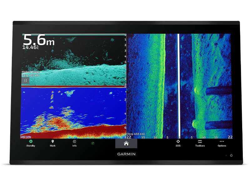
See the world below.
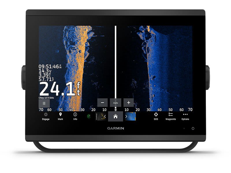
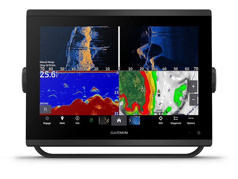
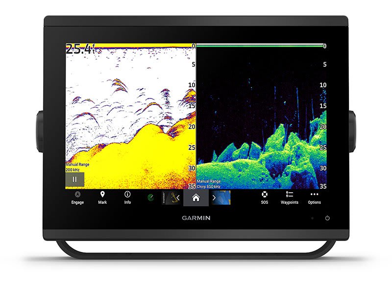
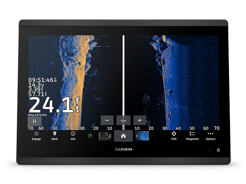
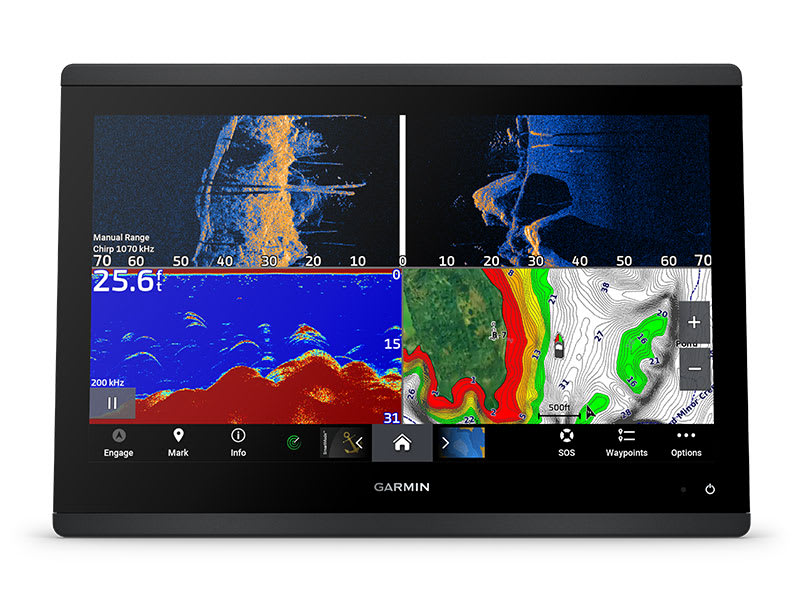
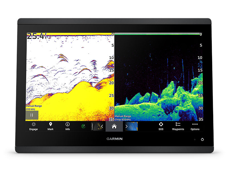
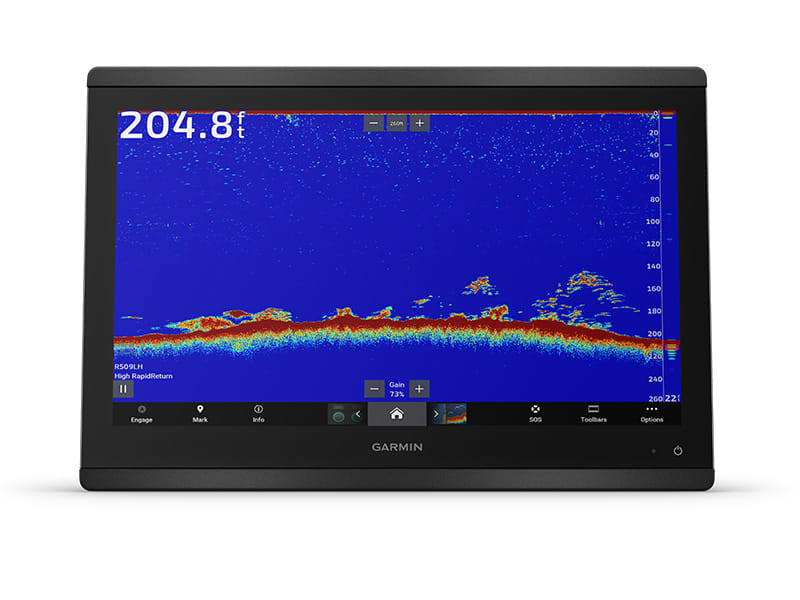
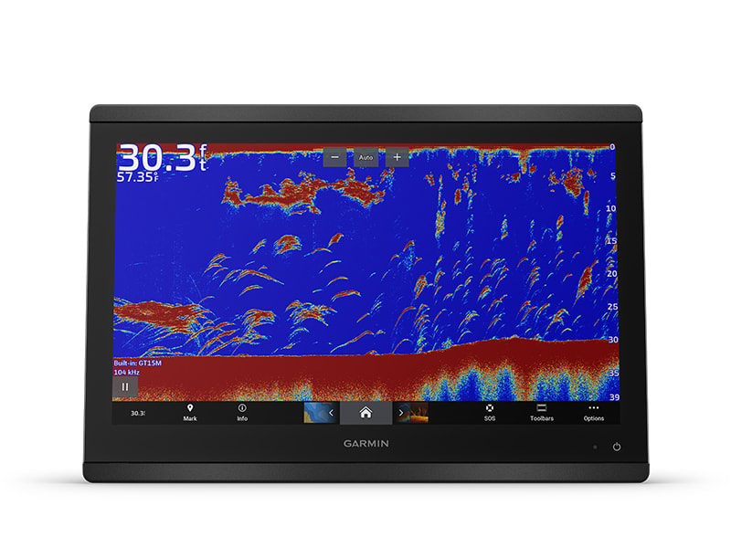
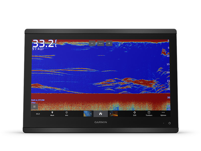
ULTRA HIGH-DEFINITION SCANNING SONAR
Get built-in Ultra High-Definition SideVü and ClearVü scanning sonars with vivid, high-contrast color palettes to help distinguish fish from structure. GPSMAP® X3 series also supports 1 kW CHIRP traditional sonar capabilities. Built-in sonar compatibility only available on xsv models.
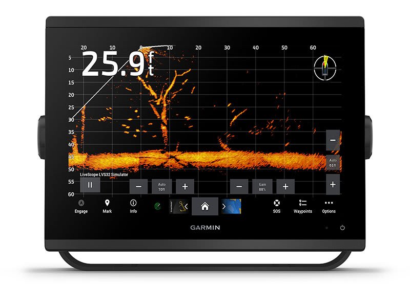
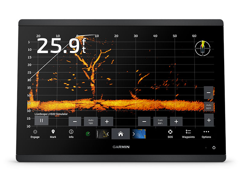
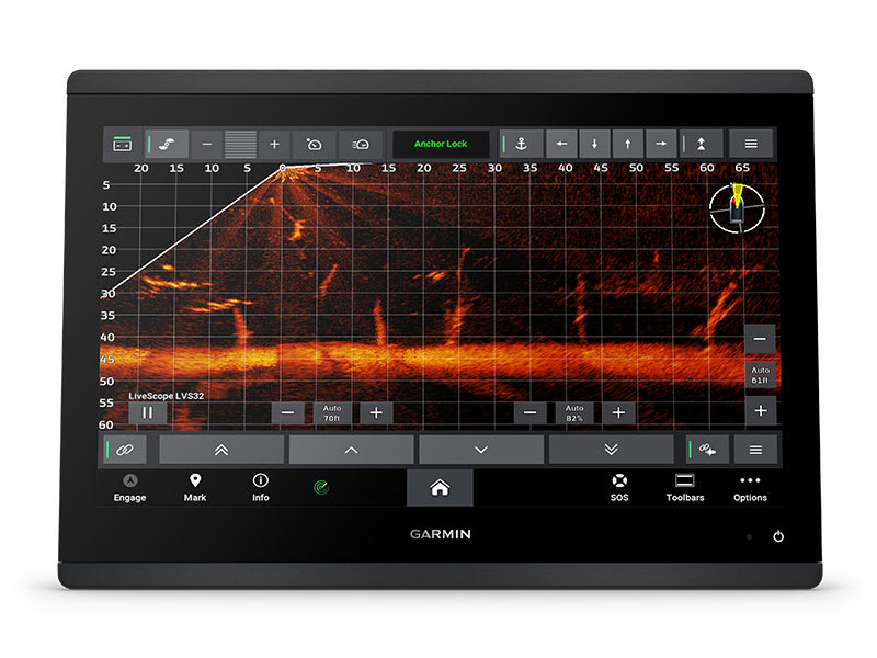
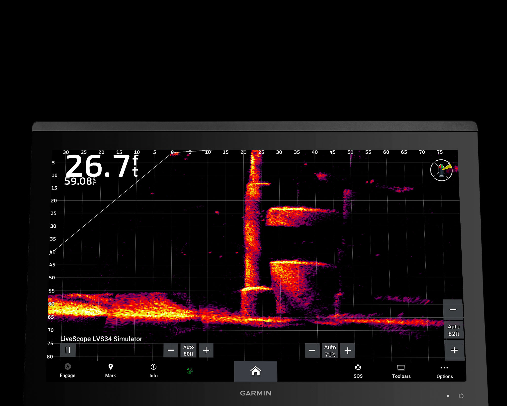
PANOPTIX™ & LIVESCOPE™ SONAR SUPPORT
Pair with Panoptix or LiveScope™ easy-to-interpret live sonar (transducer required, sold separately) to see all around your boat in real time.
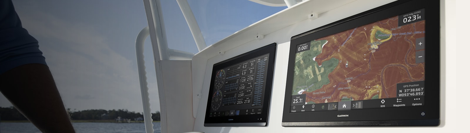
Made for your helm.
FASTER, SHARPER, SMARTER
With its added processing power and new slimline design featuring edge-to-edge glass and a smaller unit footprint, it’s easy to retrofit this plotter in a wider range of dash configurations.
IMPROVED DISPLAY OPTICS
New higher-resolution IPS displays for 9″ and 12″ plotters offer improved sunlight readability and visibility from any angle, with 50% more pixels than previous-generation 9″ GPSMAP devices.
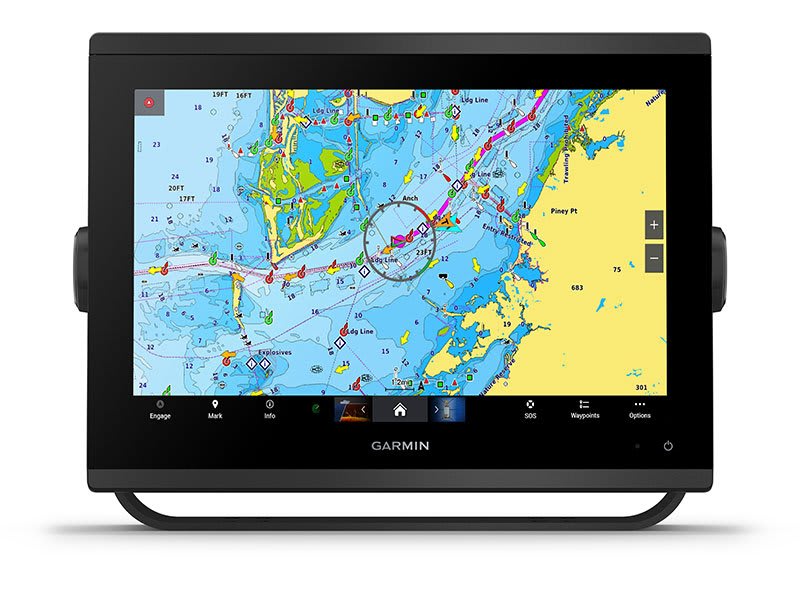
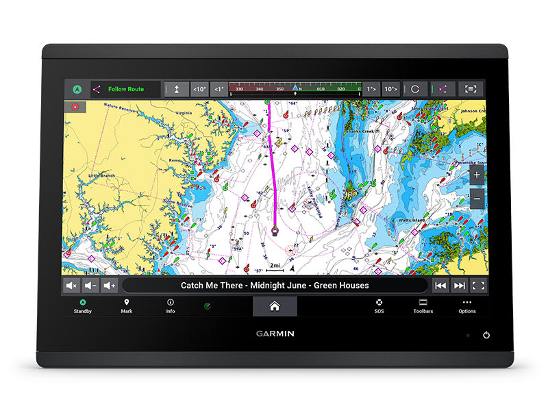
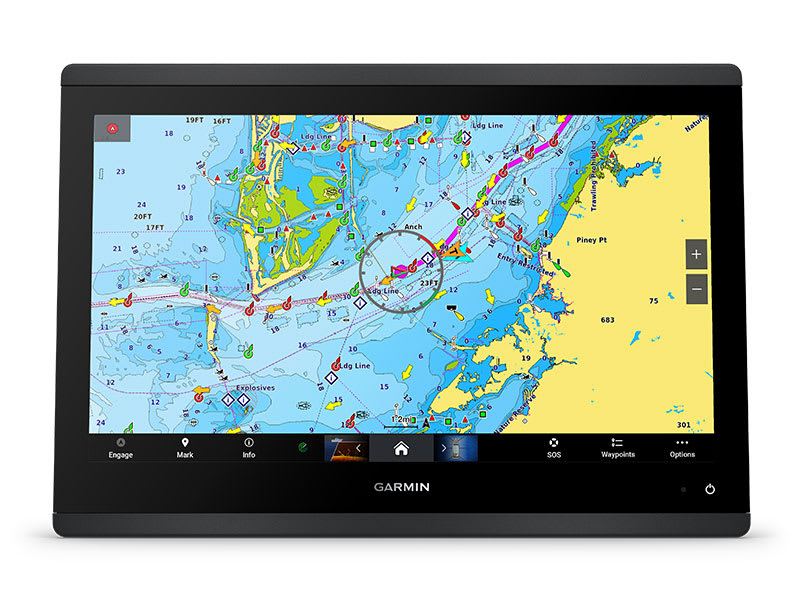
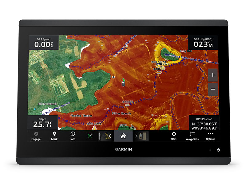
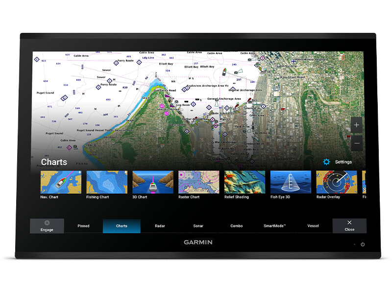
CHARTS AND MAPS
Bring a fresh new look and feel to your chartplotter with optional Garmin Navionics+™ or premium Garmin Navionics Vision+™ cartography featuring integrated coastal/inland content, access to daily updates, Auto Guidance+™ technology3 and more.
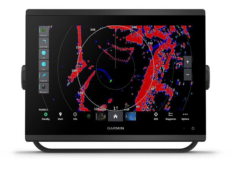
OPTIONAL RADAR BUNDLE
To help you avoid weather and traffic on the water, the compact 4 kW GMR™ 18 HD+ dome radar is available as a bundled option with your GPSMAP chartplotter/sonar package.
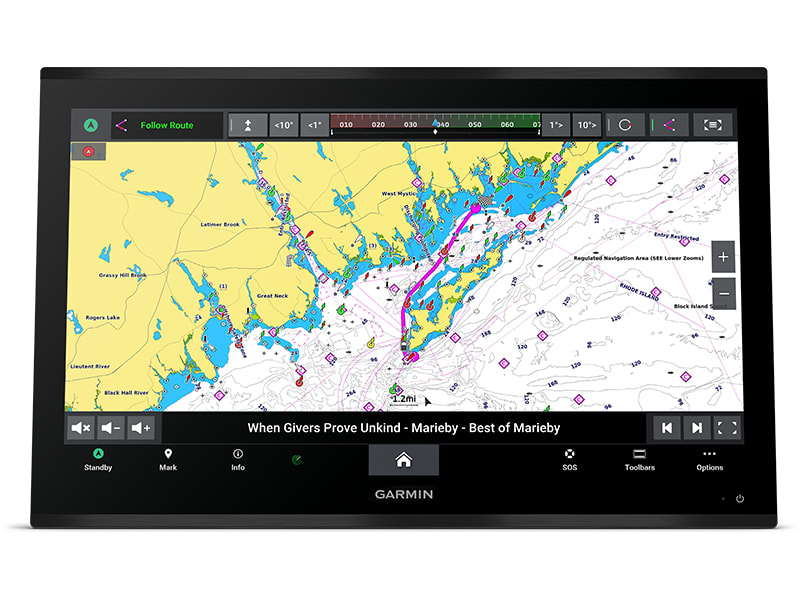
Sail and navigate with ease.
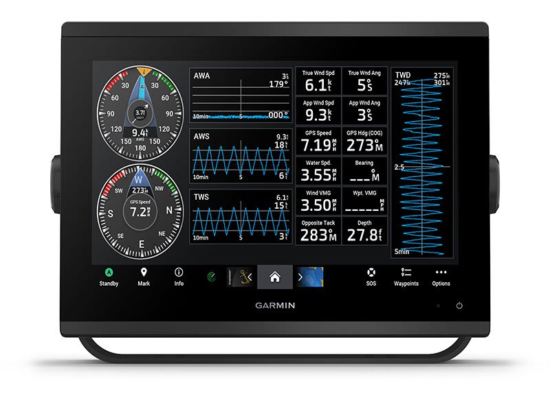
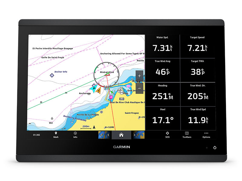
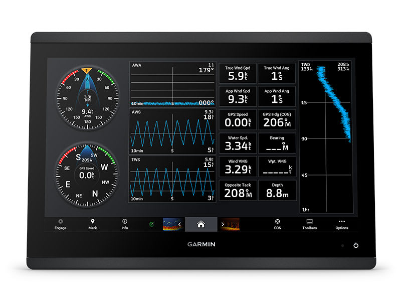
GARMIN SAILASSIST™ SAILING FEATURES
View laylines, race start line guidance, enhanced wind rose, heading and course-over-ground lines, true wind data fields and tide/current/time slider, wind angle, set and drift, wind speed and more.
OPTIONAL PREMIUM NAVIGATION FEATURES
These optional charts offer the best of Garmin and Navionics® data, Auto Guidance3 technology and other premium navigation features.
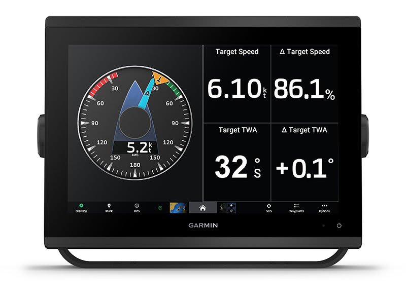
SAILING POLARS
Use the polar table to see key data, including how fast you should go at a certain wind angle and speed — so you know whether you need to adjust sail trim.
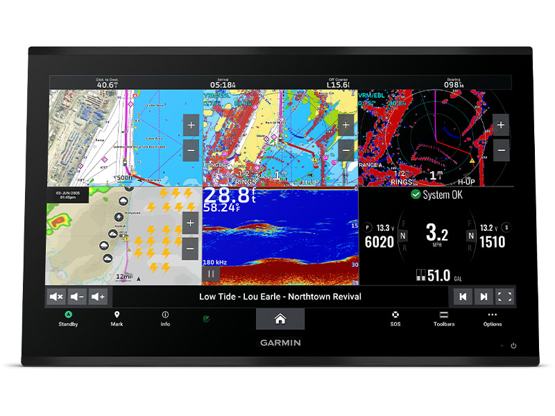
GARMIN MARINE NETWORK
If you have multiple compatible Garmin devices on your boat, you can share information — such as maps, user data, radar and IP camera video — among them.
NMEA 2000® AND NMEA 0183 NETWORKS
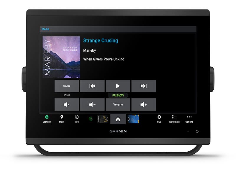
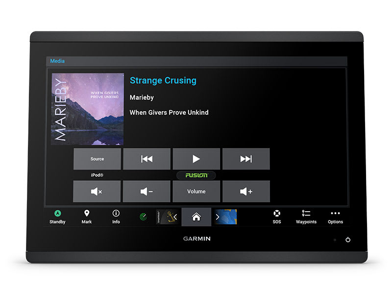
Connect to compatible autopilots, digital switching, weather, Fusion-Link™ audio system, media, VHF, AIS and more from one screen.
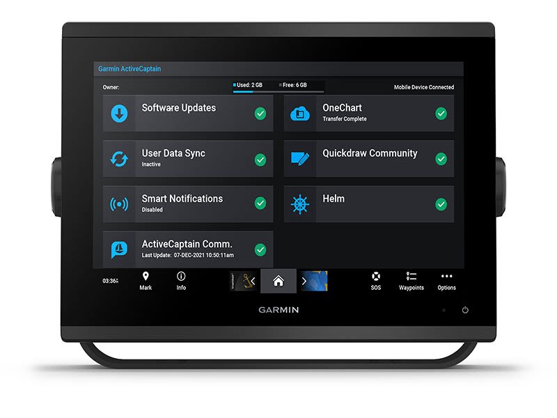
ACTIVECAPTAIN® APP
Built-in Wi-Fi® connectivity pairs with the free all-in-one mobile app for access to the OneChart™ feature, smart notifications, software updates, Garmin Helm™ digital switching, Garmin Quickdraw™ Community 4.
INTEGRATED ANT® TECHNOLOGY
Connect with some of your favourite devices, such as quatix® marine watches, gWind™ Wireless 2 transducers, GNX™ Wind marine instruments and wireless remote controls.
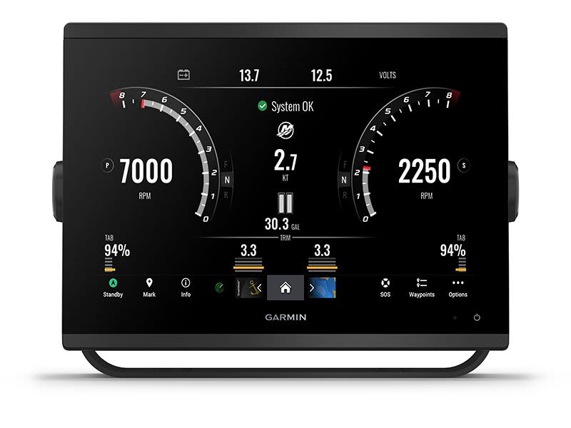
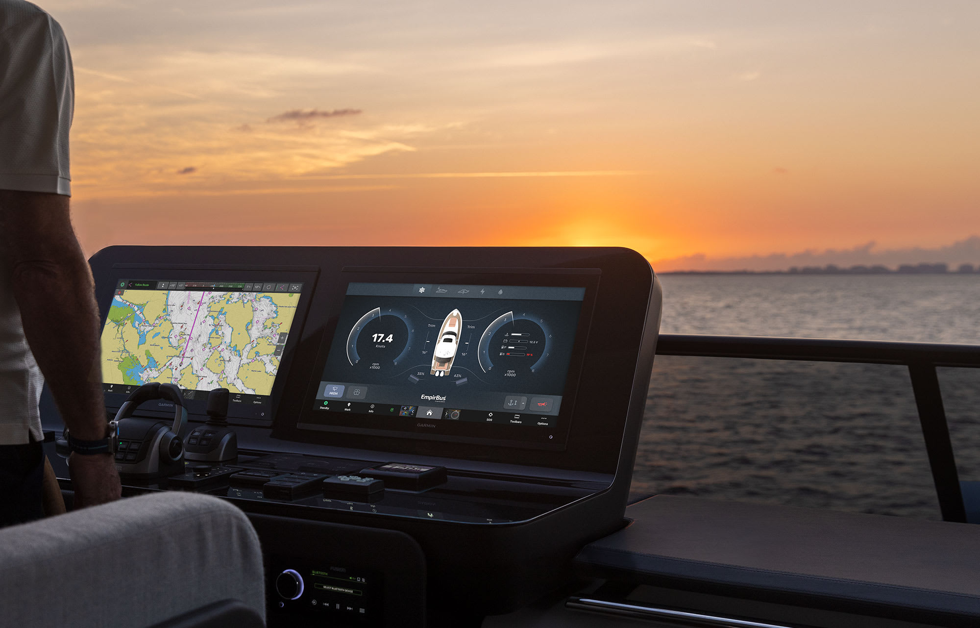
ENGINE CONNECTIVITY
Now you can connect your chartplotter to different kinds of engines, including select Yamaha engines.
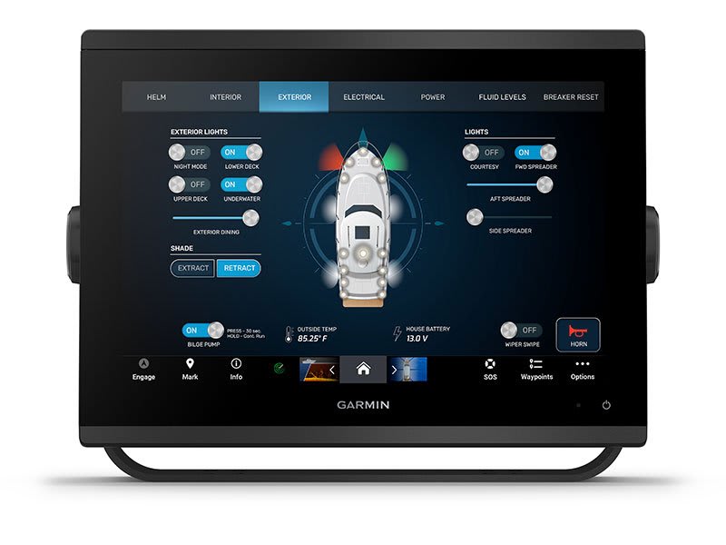
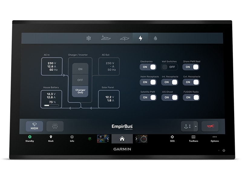
ONEHELM FEATURE
This feature brings together all the operations and capabilities of select third-party devices, such as EmpirBus™ digital switching, on one screen.
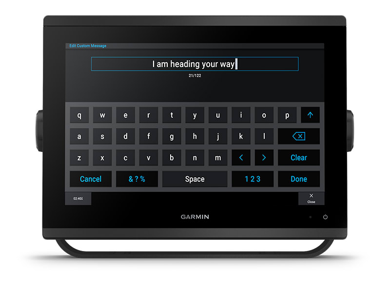
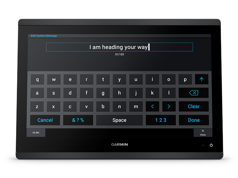
SEND INREACH® DEVICE MESSAGES
Pair your inReach satellite communicator5 to your chartplotter, and type custom messages using your MFD’s on-screen keyboard. Access your contact list or enter an email, inReach address or phone number. You can also group messages by conversation for a texting-like experience.
What’s in the box?
- GPSMAP 1253xsv chartplotter
- microSD™ card preinstalled
- Power cable
- NMEA 2000® T-connector
- NMEA 2000 drop cable (2 meters)
- 8-pin transducer to 12-pin sounder adapter cable
- Bail mount kit with knobs
- Flush mount kit with gasket
- Protective cover
- Trim piece snap covers
- Documentation
View Installation Instructions
View Owner’s Manual
SKU: 010-02367-62 -
EOFY, Garmin, Garmin Chartplotters, Marine Electronics, Sanctuary Cove, Sounders
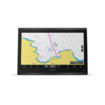
Garmin GPSMAP 1653xsv – SideVu, ClearVu and Traditional CHIRP Sonar with Mapping
-6% EOFY, Garmin, Garmin Chartplotters, Marine Electronics, Sanctuary Cove, Sounders
Garmin GPSMAP 1653xsv – SideVu, ClearVu and Traditional CHIRP Sonar with Mapping
Garmin GPSMAP 1653xsv – GET A SHARPER VIEW FROM YOUR CONNECTED HELM
With its sleek design, powerful processing and upgraded IPS display, this advanced 16″ chartplotter integrates seamlessly into your Garmin marine system.
 Easily integrate with more engines.
 Easily build your marine system by using our advanced network connectivity.
 Navigate any waters with preloaded Garmin Navionics+™ charts on select models.
 See below your boat with built-in sonar capabilities (only available on xsv models.)
 Manage your marine experience from nearly anywhere1.
See the world below.
ULTRA HIGH-DEFINITION SCANNING SONAR
Get built-in Ultra High-Definition SideVü™ and ClearVü™ scanning sonars with vivid, high-contrast colour palettes to help distinguish fish from structure. The GPSMAP X3 chartplotter series also supports 1 kW traditional sonar capabilities.Built-in sonar compatibility only available on xsv models.
PANOPTIX™ SONAR SUPPORT
Pair with Panoptix™ or LiveScope™ easy-to-interpret live sonar (transducer required, sold separately) to see all around your boat in real time.
Made for your helm.
FASTER, SHARPER, SMARTER
With its added processing power and slimline design featuring edge-to-edge glass, it’s easy to fit this plotter in a wider range of dash configurations.
BRIGHT AND CLEAR OPTICS
High-resolution IPS displays for 16″ chartplotters offer improved sunlight readability and visibility from any angle.
PRELOADED MAPPING
Experience unparalleled coverage and detail with built-in Garmin Navionics+™ integrated coastal and inland mapping that includes Auto Guidance+™ technology2 and a 1-year subscription for downloadable daily updates and more on select chartplotters.
OPTIONAL CHARTS AND MAPS
Bring a fresh new look and feel to your chartplotter with an optional upgrade to a Garmin Navionics Vision+™ premium chart subscription, featuring downloadable relief shading, satellite imagery,
POWER-POLE® SHALLOW WATER ANCHOR
By networking select Garmin chartplotters with a Force® trolling motor and your compatible Power-Pole shallow water anchoring system, you can access advanced boat control features3 from your plotter, including smart anchor auto-deployment, smart anchor jog, auto stow, anchor drag detection and auto guidance2 end-of-route anchoring. Spend more time fishing, less time positioning.
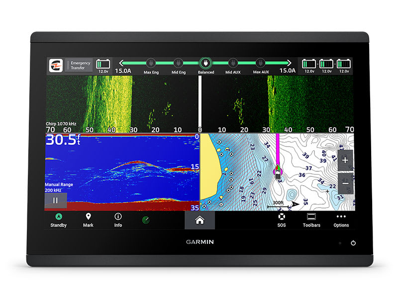
CHARGE INTEGRATION FROM POWER-POLE
Your CHARGE Marine Power Manager from Power-Pole integrates with compatible Garmin chartplotters to help keep your battery power going longer and stronger on the water. You’re able to charge batteries on the run, monitor power use, select where power is allocated, control emergency starts and even transfer power between battery banks — all from your chartplotter display.
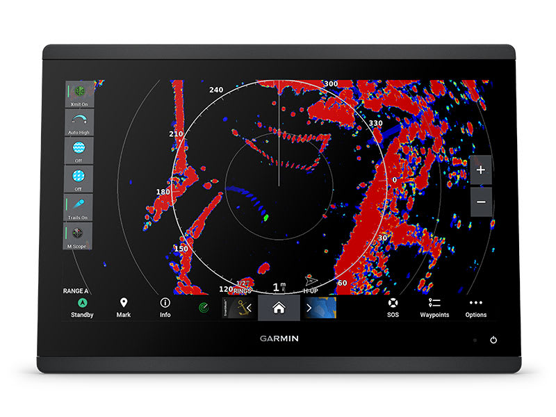
OPTIONAL RADAR BUNDLE
To help you avoid weather and traffic on the water, the compact 4 kW GMR™ 18 HD3 dome radar is available as a bundled option with select GPSMAP chartplotter/sonar packages.
TROLLING MOTOR INTEGRATION
Get support and integration for your Force trolling motor (sold separately) to gain complete control while you fish.

Sail and navigate with ease.
GARMIN SAILASSIST™ SAILING FEATURES
View laylines, race start line guidance, enhanced wind rose, heading and course-over-ground lines, true wind data fields and tide/current/time slider, wind angle, set and drift, wind speed and more.
SAILING POLARS
Use the polar table to see key data, including how fast you should go at a certain wind angle and speed — so you know whether you need to adjust sail trim.
GARMIN MARINE NETWORK
If you have multiple compatible Garmin devices on your boat, you can share information — such as maps, user data, radar and IP camera video — among them.
NMEA 2000® AND NMEA 0183 NETWORKS
Connect to compatible autopilots, digital switching, weather, the Fusion audio system, media, VHF, AIS and more from one screen.
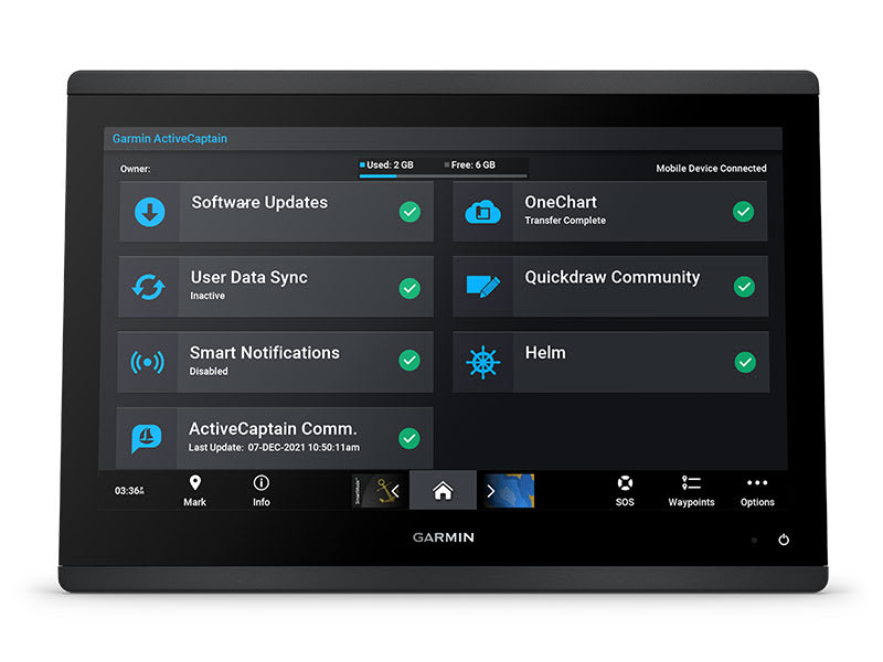
ACTIVECAPTAIN® APP
Built-in Wi-Fi® connectivity pairs with the free all-in-one mobile app for access to the OneChart™ feature, smart notifications, software updates, Helm app, Garmin Quickdraw™ Community data and more1.
INTEGRATED ANT® TECHNOLOGY
Connect with some of your favorite devices, such as quatix® marine watches, gWind™ Wireless 2 transducers GNX™ Wind marine instruments and wireless remote controls.
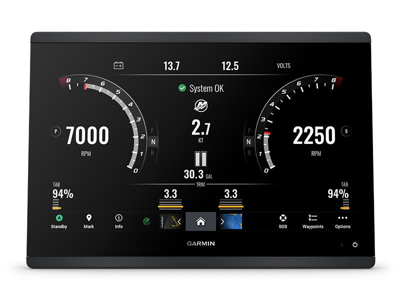
ENGINE CONNECTIVITY
You can connect your chartplotter to different engines, including select Yamaha® engines.
ONEHELM FEATURE
This feature brings together all the operations and capabilities of select third-party devices, such as EmpirBus™ digital switching, on one screen.
SEND INREACH® DEVICE MESSAGES
Pair your inReach satellite communicator4 to your chartplotter, and type custom messages using your MFD’s on-screen keyboard. Access your contact list or enter an email, inReach address or phone number. You can also group messages by conversation for a texting-like experience.
What’s in the box?
- GPSMAP® 1653xsv Chartplotter
- microSD™ card preinstalled
- 8-pin transducer to 12-pin sounder adapter cable
- Power cable
- Flush mount kit with gasket
- Protective cover
- Trim piece snap covers
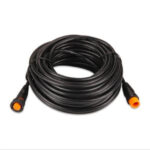
- Backbone/drop cable (2 metres) and T-connector for the NMEA 2000® network
- Documentation
View Installation Instructions
View Owner’s Manual
SKU: 010-02919-04 -
Garmin, Garmin Chartplotters, Sanctuary Cove
Garmin GPSMAP 753xsv – Chartplotter with SideVü, ClearVü and Traditional CHIRP Sonar with Garmin Navionics+ Mapping
-10% Garmin, Garmin Chartplotters, Sanctuary Cove
Garmin GPSMAP 753xsv – Chartplotter with SideVü, ClearVü and Traditional CHIRP Sonar with Garmin Navionics+ Mapping
Garmin GPSMAP 753xsv – GET A SHARPER VIEW FROM YOUR CONNECTED HELM
With its sleek design, powerful processing and upgraded IPS display, this advanced 7″ chartplotter integrates seamlessly into your Garmin marine system.
Easily integrate with more engines.
Connect to compatible third-party devices with OneHelm™ digital switching.
Easily build your marine system using the best network connectivity.
Compatible with premium maps and charts1 for the best in Garmin navigation.
See below your boat with built-in sonar capabilities
Manage your marine experience from nearly anywhere1.
SKU: 010-02365-62 -
Garmin, Garmin Chartplotters, Sanctuary Cove
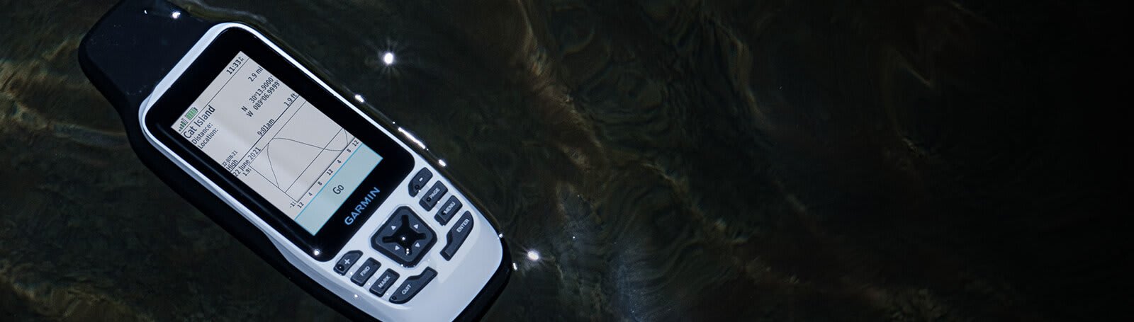
Garmin GPSMAP 79s – Marine Handheld with Worldwide Basemap
-10% Garmin, Garmin Chartplotters, Sanctuary Cove
Garmin GPSMAP 79s – Marine Handheld with Worldwide Basemap
Garmin GPSMAP 79s – CAST OFF CONFIDENTLY
Stay on course, and track more adventures with these rugged, floating handhelds.
 It’s water-resistant, it floats, and it’s fogproof, so it belongs on the water — just like you.
 This thing can remember up to 10,000 waypoints and more, so you don’t have to.
 It’s nice to have reliable positioning when you’re out on the water.
 The built-in compass will point you in the right direction.
 Get the best of Garmin and Navionics® data with optional BlueChart® g3 coastal charts.
 Stay out longer with up to 19 hours of battery life in GPS mode.
Built for life on the boat.
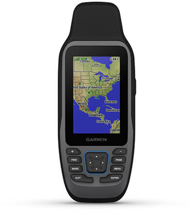
RUGGED HANDHELD
This handheld is water-resistant IPX7 with a high-resolution colour display you can read in the sun. The glass is even scratch-resistant and fogproof.
DESIGNED TO FLOAT
If rough waters come and the handheld goes overboard, don’t worry. This device floats.

BATTERY LIFE
User-replaceable AA batteries (not included) provide up to 19 hours of battery life in GPS tracking mode.
Exactly what you need to navigate.
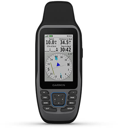
ACCURATE TRACKING
With support for multiple satellite constellations — such as GPS, GLONASS, Galileo, QZSS and SBAS — you’ll get accurate, reliable tracking and positioning around the world.
INCREASED MEMORY
More memory than previous models means you can save and track 10,000 waypoints, 250 routes and 300 fitness activity files.
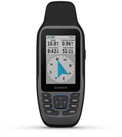
BUILT-IN COMPASS
The 3-axis tilt-compensated electronic compass shows your heading — even while the boat is standing still.

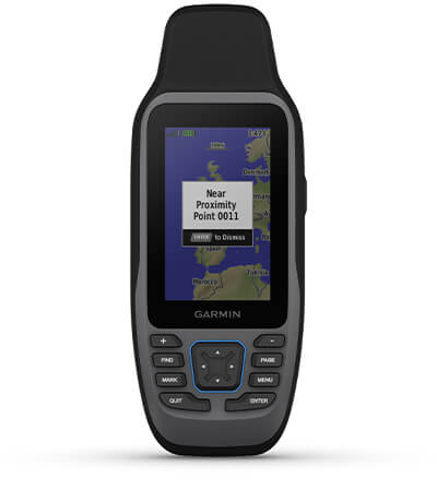
BLUECHART COVERAGE
Preloaded BlueChart g3 coastal charts (GPSMAP 79sc only) give you leading-edge coverage, clarity and detail with integrated Garmin and Navionics data.
What’s in the box
- GPSMAP 79s
- Lanyard
- USB cable
- Documentation
View Owner’s Manual
Garmin® Training Video – Cast off confidently with the GPSMAP® 79 series
SKU: 010-02635-00 -
Garmin, Garmin Chartplotters, Sanctuary Cove
Garmin GPSMAP 79sc – Marine Handheld Preloaded with BlueChart g3 Coastal Charts
-10%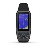 Garmin, Garmin Chartplotters, Sanctuary Cove
Garmin GPSMAP 79sc – Marine Handheld Preloaded with BlueChart g3 Coastal Charts
Garmin GPSMAP 79sc – Marine Handheld Preloaded with BlueChart g3 Coastal Charts – CAST OFF CONFIDENTLY
Stay on course, and track more adventures with these rugged, floating handhelds.
It’s water-resistant, it floats, and it’s fogproof, so it belongs on the water — just like you.
This thing can remember up to 10,000 waypoints and more, so you don’t have to.
It’s nice to have reliable positioning when you’re out on the water.
The built-in compass will point you in the right direction.
Get the best of Garmin and Navionics® data with optional BlueChart® g3 coastal charts.
Stay out longer with up to 19 hours of battery life in GPS mode.
Built for life on the boat.
RUGGED HANDHELD
This handheld is water-resistant IPX7 with a high-resolution colour display you can read in the sun. The glass is even scratch-resistant and fogproof.
DESIGNED TO FLOAT
If rough waters come and the handheld goes overboard, don’t worry. This device floats.
BATTERY LIFE
User-replaceable AA batteries (not included) provide up to 19 hours of battery life in GPS tracking mode.
Exactly what you need to navigate.
ACCURATE TRACKING
With support for multiple satellite constellations — such as GPS, GLONASS, Galileo, QZSS and SBAS — you’ll get accurate, reliable tracking and positioning around the world.
INCREASED MEMORY
More memory than previous models means you can save and track 10,000 waypoints, 250 routes and 300 fitness activity files.
BUILT-IN COMPASS
The 3-axis tilt-compensated electronic compass shows your heading — even while the boat is standing still.
BLUECHART COVERAGE
Preloaded BlueChart g3 coastal charts (GPSMAP 79sc only) give you leading-edge coverage, clarity and detail with integrated Garmin and Navionics data.
What’s in the box
- GPSMAP 79s or 79sc, depending on the version selected
- Lanyard
- USB cable
- Documentation
View Owner’s Manual
Garmin® Training Video – Cast off confidently with the GPSMAP® 79 series
SKU: 010-02635-03 -
EOFY, Garmin, Garmin Chartplotters, Sanctuary Cove
Garmin GPSMAP 8412xsv – Chartplotter With Worldwide Basemap & Sonar
-10%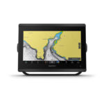 EOFY, Garmin, Garmin Chartplotters, Sanctuary Cove
Garmin GPSMAP 8412xsv – Chartplotter With Worldwide Basemap & Sonar
Garmin GPSMAP 8412xsv – With Worldwide Basemap & Sonar – SERIOUS ANGLERS, CRUISERS, SAILORS AND SAIL RACERS DEMAND SERIOUS EQUIPMENT
The easy-to-use, easy-to-install chartplotter/sonar combo delivers MFD performance in a combo-size package.

Get wider viewing angles and superior clarity on the touchscreen with a full HD in-plane switching (IPS) display.
It’s compatible with premium maps and charts for the best in Garmin navigation.
Easily build your marine system using the best of network connectivity.

See below and around your boat with built-in sonar capabilities (transducers sold separately)

From ANT® technology to Wi-Fi® networking, there are countless ways to connect to your system.

With SmartMode™ station controls, everything is designed to give you quick, one-touch access to the information you need.
SKU: 010-02092-02 -
EOFY, Garmin, Garmin Chartplotters, Sanctuary Cove
Garmin GPSMAP 8416xsv – Chartplotter With Worldwide Basemap & Sonar
-10% EOFY, Garmin, Garmin Chartplotters, Sanctuary Cove
Garmin GPSMAP 8416xsv – Chartplotter With Worldwide Basemap & Sonar
Garmin GPSMAP 8416xsv – Chartplotter With Worldwide Basemap & Sonar – SERIOUS ANGLERS, CRUISERS, SAILORS AND SAIL RACERS DEMAND SERIOUS EQUIPMENT
The easy-to-use, easy-to-install chartplotter/sonar combo delivers MFD performance in a combo-size package.
Get wider viewing angles and superior clarity on the touchscreen with a full HD in-plane switching (IPS) display.
It’s compatible with premium maps and charts for the best in Garmin navigation.
Easily build your marine system using the best of network connectivity.
See below and around your boat with built-in sonar capabilities (transducers sold separately)
From ANT® technology to Wi-Fi® networking, there are countless ways to connect to your system.
With SmartMode™ station controls, everything is designed to give you quick, one-touch access to the information you need.
SKU: 010-02093-02 -
Garmin, Garmin Chartplotters
Garmin GPSMAP 8417 MFD- Chartplotter With Worldwide Basemap
Garmin GPSMAP 8417 MFD- Chartplotter With Worldwide Basemap – TAKE CONTROL OF A BEAUTIFUL HELM
The large-format MFD lets you experience a beautifully powerful, completely networked helm at your fingertips.
Premium full HD touchscreen features Garmin’s highest resolution display.
It’s compatible with premium maps and charts for the best in Garmin navigation.
Easily build your marine system using the best of network connectivity.
From ANT® technology to Wi-Fi® networking, there are countless ways to connect to your system.
Take the guesswork out of sailing with clear laylines and more right on the screen.
With SmartMode™ station controls, everything is designed to give you quick, one-touch access to the information you need.
SKU: 010-01510-00 -
Garmin, Garmin Chartplotters
Garmin GPSMAP 8422 MFD – Chartplotter With Worldwide Basemap
Garmin GPSMAP 8422 MFD- Chartplotter With Worldwide Basemap – TAKE CONTROL OF A BEAUTIFUL HELM
The large-format MFD lets you experience a beautifully powerful, completely networked helm at your fingertips.
Premium full HD touchscreen features Garmin’s highest resolution display.
It’s compatible with premium maps and charts for the best in Garmin navigation.
Easily build your marine system using the best of network connectivity.
From ANT® technology to Wi-Fi® networking, there are countless ways to connect to your system.
Take the guesswork out of sailing with clear laylines and more right on the screen.
With SmartMode™ station controls, everything is designed to give you quick, one-touch access to the information you need.
SKU: 010-01511-00 -
Garmin, Garmin Chartplotters
Garmin GPSMAP 8424 MFD – Chartplotter With Worldwide Basemap
Garmin GPSMAP 8424 MFD – Chartplotter With Worldwide Basemap – TAKE CONTROL OF A BEAUTIFUL HELM
The large-format MFD lets you experience a beautifully powerful, completely networked helm at your fingertips.
Premium full HD touchscreen features Garmin’s highest resolution display.
It’s compatible with premium maps and charts for the best in Garmin navigation.
Easily build your marine system using the best of network connectivity.
From ANT® technology to Wi-Fi® networking, there are countless ways to connect to your system.
Take the guesswork out of sailing with clear laylines and more right on the screen.
With SmartMode™ station controls, everything is designed to give you quick, one-touch access to the information you need.
SKU: 010-01512-00 -
Garmin, Garmin VHF and AIS, Sanctuary Cove
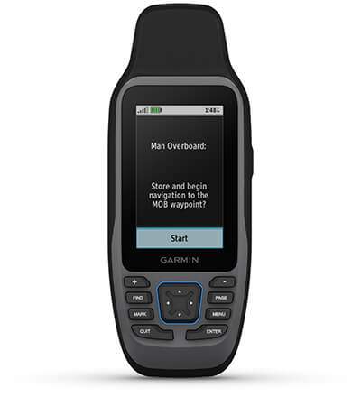
Garmin GPSMAP 86i – Marine Handheld With inReach® Capabilities
-14% Garmin, Garmin VHF and AIS, Sanctuary Cove
Garmin GPSMAP 86i – Marine Handheld With inReach® Capabilities
Garmin GPSMAP 86i – CAST OFF CONFIDENTLY WITH A PREMIUM MARINE HANDHELD GPS
Stay on course with the GPSMAP 86i handheld. It provides all the outdoor functions and global communications of the GPSMAP® 66 series and adds on-the-water features — including wireless connectivity to your onboard marine system.
It’s water resistant, and it floats, so it’s as at home on the water as you.

See all your marine system info at a glance with boat data streaming.

Cruise with peace of mind. inReach interactive SOS is there if you need it2.

Send and receive text messages from anywhere2.

Put convenient control of your autopilot and Fusion® systems at your fingertips.
Stay out longer with up to 35 hours of battery life in 10-minute tracking mode.
SKU: 010-02236-01 -
EOFY, Garmin, Garmin Chartplotters, Sanctuary Cove
Garmin GPSMAP 9010xsv – Premium chartplotter with worldwide basemap and sonar
-8% EOFY, Garmin, Garmin Chartplotters, Sanctuary Cove
Garmin GPSMAP 9010xsv – Premium chartplotter with worldwide basemap and sonar
Garmin GPSMAP 9010xsv is a premium chartplotter with a 10-inch HD touchscreen display, worldwide basemap, built-in sonar and Garmin BlueNet gigabit network connectivity.
SKU: 010-03175-02 -
EOFY, Garmin, Garmin Chartplotters, Sanctuary Cove
Garmin GPSMAP 9013xsv – Premium chartplotter with worldwide basemap and sonar
-10%EOFY, Garmin, Garmin Chartplotters, Sanctuary CoveGarmin GPSMAP 9013xsv – Premium chartplotter with worldwide basemap and sonar
Garmin GPSMAP 9010xsv is a premium chartplotter with a 10-inch HD touchscreen display, worldwide basemap, built-in sonar and Garmin BlueNet gigabit network connectivity.
SKU: 010-03176-02 -
EOFY, Garmin, Garmin Chartplotters, Sanctuary Cove
Garmin GPSMAP 9017xsv – Premium chartplotter with worldwide basemap and sonar
-8%EOFY, Garmin, Garmin Chartplotters, Sanctuary CoveGarmin GPSMAP 9017xsv – Premium chartplotter with worldwide basemap and sonar
Garmin GPSMAP 9010xsv is a premium chartplotter with a 10-inch HD touchscreen display, worldwide basemap, built-in sonar and Garmin BlueNet gigabit network connectivity.
SKU: 010-03177-02 -
EOFY, Garmin, Garmin Chartplotters, Sanctuary Cove
Garmin GPSMAP 9019 – 19inch Premium chartplotter with worldwide basemap
-6%EOFY, Garmin, Garmin Chartplotters, Sanctuary CoveGarmin GPSMAP 9019 – 19inch Premium chartplotter with worldwide basemap
Garmin GPSMAP 9022 – 19inch Premium Chartplotter with worldwide basemap
Plot your paradise
FROM YOUR PARADISESEE YOUR CHARTS, VIEW ENTERTAINMENT AND MORE IN 4K
CLARITY, CONTROL AND LUXURY AT THE HELM

THE SPEED YOU NEEDUP TO SEVEN TIMES FASTER PROCESSING POWER AND GIGABIT SPEEDS ON THE GARMIN BLUENET™ NETWORK
CONNECTION IS KEYBUILD AN EXTENSIVE, TOP-OF-THE-LINE ECOSYSTEM
YOU’VE NEVER SEEN FISH THIS CLEARLY
WELCOME TO 4K PARADISE
It’s the industry’s first integrated 4K resolution touchscreen chartplotter. Enjoy edge-to-edge clarity and luxury on a glass helm with premium design and materials plus enhanced connectivity and speed.
 PREMIUM 4K IPS SUNLIGHT-READABLE TOUCHSCREEN DISPLAY
 UP TO 7 TIMES FASTER PROCESSING POWER THAN PREVIOUS GENERATIONS
 GIGABIT SPEEDS ON THE GARMIN BLUENET™ NETWORK
 VIDEO INTEGRATION CAPABILITIES WITH HDCP DISTRIBUTION SEE SONAR TARGETS LIKE NEVER BEFORE ON THE 4K DISPLAY1
 NETWORK WITH MULTIPLE CHARTPLOTTERS, CAMERAS AND SONARS
WHAT YOU’LL LOVE
PREMIUM CHARTPLOTTER
The 4K resolution IPS sunlight-readable touchscreen display is available in the industry’s largest integrated chartplotter size. Edge-to-edge design provides a seamless and luxurious modern look.
FASTER. MUCH FASTER.
Processing power is 7 times faster than previous generations for superior performance; draw charts quickly, and calculate Auto Guidance+™ routes2 with lightning speed with an optional Garmin Navionics+™ subscription.
GARMIN BLUENET NETWORK
Build extensive networks with multiple chartplotters, cameras, radars and sonars — and enjoy 10 times faster networking speeds with minimal lag.
ENTERTAINMENT OPTIONS
Enjoy audio and video integrations that allow you to show and hear the same video throughout the screens and speakers on your network.
HIGH-DEFINITION SONAR
Fish in stunning high definition. Hook up to any of our sonar modules, and view sonar targets on the 4K display (transducers sold separately).
CONNECT YOUR ECOSYSTEM
Take command through digital system integrations to monitor, automate and control your vessel. The chartplotter uses the NMEA 2000® and NMEA 0183 networks to connect to your compatible accessories.
FOR CAPTAINS WHO DEMAND THE BEST CONNECT
 SOFTWARE UPDATES – Get wireless software updates via the ActiveCaptain® app with your compatible smartphone or tablet. ENGINE MONITORING – Keep tabs on engine performance with extensive engine integration.
 CUSTOM LOOK – Manufacturers can customise the homepage layout and splash screen for a brand tailored experience.
Navigate
 MAPPING – Navigate with optional Garmin Navionics+™ charts that include Auto Guidance+ technology, daily updates and more2 (subscription required).
 PREMIUM CHARTS – Get support for Garmin Navionics Vision+™ charts with premium relief shading and satellite imagery.
 KNOW WHERE YOU ARE – Get your precise location with the included GPS 24xd position receiver and antenna.
 AUTOPILOT – Control the autopilot with any compatible chartplotter on the network with autopilot integration.
INTEGRATE
CONNECT CAMERAS – Get extensive camera support and control to see footage directly on the chartplotter. SURROUND VIEW SYSTEM – Get a bird’s-eye view with support for our Surround View Camera System (accessory purchase required).
 CONTROL WITH YOUR WATCH – Connect to your chartplotter with your compatible Garmin smartwatch.
 WIRELESS CONNECTIVITY – Connect compatible devices with integrated BLUETOOTH® and ANT® technologies.
 FISH MAPPING – Get comprehensive fishing data with the Fish Mapping™ feature from SiriusXM® Radio (accessory purchase and subscription required).
 VERBAL COMMANDS – Use spoken commands to control the chartplotter through your compatible headset.
 WEATHER-RESISTANT – The GPSMAP 9000 chartplotter is built for harsh marine conditions with an IPX7 water-resistance rating.1Sonar black box and transducers sold separately2Auto Guidance+ is for planning purposes only and does not replace safe navigation operationsThe Bluetooth word mark and logos are registered trademarks owned by Bluetooth SIG, Inc. and any use of such marks by Garmin is under licence. Sirius, XM and all related marks and logos are trademarks of Sirius XM Radio Inc.Engineering enhancements are ongoing and may not be reflected in the pictures, videos and specifications.
In the box
- GPSMAP® 9022 Chartplotter
- Trim snap cover
- Protective cover
- Flush mount hardware
- Power cable
- GPS 24xd NMEA 2000® (with pole mount, flush mount and under deck mount adapters)
- NMEA 2000 backbone/drop cable (2 metres)
- NMEA 2000 power cable
- NMEA 2000 T-connector and terminator kit
- Documentation
Installation Instruction
Owner’s Manual
SKU: 010-02673-00 -
Garmin, Garmin Chartplotters
Garmin GPSMAP 9022 – 22inch Premium chartplotter with worldwide basemap
Garmin GPSMAP 9022 – 22″ Premium Chartplotter with worldwide basemap
Plot your paradise
FROM YOUR PARADISESEE YOUR CHARTS, VIEW ENTERTAINMENT AND MORE IN 4K
CLARITY, CONTROL AND LUXURY AT THE HELM
THE SPEED YOU NEEDUP TO SEVEN TIMES FASTER PROCESSING POWER AND GIGABIT SPEEDS ON THE GARMIN BLUENET™ NETWORK
CONNECTION IS KEYBUILD AN EXTENSIVE, TOP-OF-THE-LINE ECOSYSTEM
YOU’VE NEVER SEEN FISH THIS CLEARLY
WELCOME TO 4K PARADISE
It’s the industry’s first integrated 4K resolution touchscreen chartplotter. Enjoy edge-to-edge clarity and luxury on a glass helm with premium design and materials plus enhanced connectivity and speed.
PREMIUM 4K IPS SUNLIGHT-READABLE TOUCHSCREEN DISPLAY UP TO 7 TIMES FASTER PROCESSING POWER THAN PREVIOUS GENERATIONS GIGABIT SPEEDS ON THE GARMIN BLUENET™ NETWORK VIDEO INTEGRATION CAPABILITIES WITH HDCP DISTRIBUTION SEE SONAR TARGETS LIKE NEVER BEFORE ON THE 4K DISPLAY1 NETWORK WITH MULTIPLE CHARTPLOTTERS, CAMERAS AND SONARSWHAT YOU’LL LOVE
PREMIUM CHARTPLOTTER
The 4K resolution IPS sunlight-readable touchscreen display is available in the industry’s largest integrated chartplotter size. Edge-to-edge design provides a seamless and luxurious modern look.
FASTER. MUCH FASTER.
Processing power is 7 times faster than previous generations for superior performance; draw charts quickly, and calculate Auto Guidance+™ routes2 with lightning speed with an optional Garmin Navionics+™ subscription.
GARMIN BLUENET NETWORK
Build extensive networks with multiple chartplotters, cameras, radars and sonars — and enjoy 10 times faster networking speeds with minimal lag.
ENTERTAINMENT OPTIONS
Enjoy audio and video integrations that allow you to show and hear the same video throughout the screens and speakers on your network.
HIGH-DEFINITION SONAR
Fish in stunning high definition. Hook up to any of our sonar modules, and view sonar targets on the 4K display (transducers sold separately).
CONNECT YOUR ECOSYSTEM
Take command through digital system integrations to monitor, automate and control your vessel. The chartplotter uses the NMEA 2000® and NMEA 0183 networks to connect to your compatible accessories.
FOR CAPTAINS WHO DEMAND THE BEST CONNECT
SOFTWARE UPDATES – Get wireless software updates via the ActiveCaptain® app with your compatible smartphone or tablet. ENGINE MONITORING – Keep tabs on engine performance with extensive engine integration. CUSTOM LOOK – Manufacturers can customise the homepage layout and splash screen for a brand tailored experience.Navigate
MAPPING – Navigate with optional Garmin Navionics+™ charts that include Auto Guidance+ technology, daily updates and more2 (subscription required). PREMIUM CHARTS – Get support for Garmin Navionics Vision+™ charts with premium relief shading and satellite imagery. KNOW WHERE YOU ARE – Get your precise location with the included GPS 24xd position receiver and antenna. AUTOPILOT – Control the autopilot with any compatible chartplotter on the network with autopilot integration.INTEGRATE
CONNECT CAMERAS – Get extensive camera support and control to see footage directly on the chartplotter. SURROUND VIEW SYSTEM – Get a bird’s-eye view with support for our Surround View Camera System (accessory purchase required). CONTROL WITH YOUR WATCH – Connect to your chartplotter with your compatible Garmin smartwatch. WIRELESS CONNECTIVITY – Connect compatible devices with integrated BLUETOOTH® and ANT® technologies. FISH MAPPING – Get comprehensive fishing data with the Fish Mapping™ feature from SiriusXM® Radio (accessory purchase and subscription required). VERBAL COMMANDS – Use spoken commands to control the chartplotter through your compatible headset. WEATHER-RESISTANT – The GPSMAP 9000 chartplotter is built for harsh marine conditions with an IPX7 water-resistance rating.1Sonar black box and transducers sold separately2Auto Guidance+ is for planning purposes only and does not replace safe navigation operationsThe Bluetooth word mark and logos are registered trademarks owned by Bluetooth SIG, Inc. and any use of such marks by Garmin is under licence. Sirius, XM and all related marks and logos are trademarks of Sirius XM Radio Inc.Engineering enhancements are ongoing and may not be reflected in the pictures, videos and specifications.In the box
- GPSMAP® 9022 Chartplotter
- Trim snap cover
- Protective cover
- Flush mount hardware
- Power cable
- GPS 24xd NMEA 2000® (with pole mount, flush mount and under deck mount adapters)
- NMEA 2000 backbone/drop cable (2 metres)
- NMEA 2000 power cable
- NMEA 2000 T-connector and terminator kit
- Documentation
Installation Instruction
Owner’s Manual
SKU: 010-02674-00 -
Charts & Maps, Garmin
Garmin GPSMAP 9024 – 24″ Premium Chartplotter with worldwide basemap
Garmin GPSMAP 9024 – 24″ Premium Chartplotter with worldwide basemap
Plot your paradise
FROM YOUR PARADISESEE YOUR CHARTS, VIEW ENTERTAINMENT AND MORE IN 4K
CLARITY, CONTROL AND LUXURY AT THE HELM
THE SPEED YOU NEEDUP TO SEVEN TIMES FASTER PROCESSING POWER AND GIGABIT SPEEDS ON THE GARMIN BLUENET™ NETWORK
CONNECTION IS KEYBUILD AN EXTENSIVE, TOP-OF-THE-LINE ECOSYSTEM
YOU’VE NEVER SEEN FISH THIS CLEARLY
WELCOME TO 4K PARADISE
It’s the industry’s first integrated 4K resolution touchscreen chartplotter. Enjoy edge-to-edge clarity and luxury on a glass helm with premium design and materials plus enhanced connectivity and speed.
PREMIUM 4K IPS SUNLIGHT-READABLE TOUCHSCREEN DISPLAY UP TO 7 TIMES FASTER PROCESSING POWER THAN PREVIOUS GENERATIONS GIGABIT SPEEDS ON THE GARMIN BLUENET™ NETWORK VIDEO INTEGRATION CAPABILITIES WITH HDCP DISTRIBUTION SEE SONAR TARGETS LIKE NEVER BEFORE ON THE 4K DISPLAY1 NETWORK WITH MULTIPLE CHARTPLOTTERS, CAMERAS AND SONARSWHAT YOU’LL LOVE
PREMIUM CHARTPLOTTER
The 4K resolution IPS sunlight-readable touchscreen display is available in the industry’s largest integrated chartplotter size. Edge-to-edge design provides a seamless and luxurious modern look.
FASTER. MUCH FASTER.
Processing power is 7 times faster than previous generations for superior performance; draw charts quickly, and calculate Auto Guidance+™ routes2 with lightning speed with an optional Garmin Navionics+™ subscription.
GARMIN BLUENET NETWORK
Build extensive networks with multiple chartplotters, cameras, radars and sonars — and enjoy 10 times faster networking speeds with minimal lag.
ENTERTAINMENT OPTIONS
Enjoy audio and video integrations that allow you to show and hear the same video throughout the screens and speakers on your network.
HIGH-DEFINITION SONAR
Fish in stunning high definition. Hook up to any of our sonar modules, and view sonar targets on the 4K display (transducers sold separately).
CONNECT YOUR ECOSYSTEM
Take command through digital system integrations to monitor, automate and control your vessel. The chartplotter uses the NMEA 2000® and NMEA 0183 networks to connect to your compatible accessories.
FOR CAPTAINS WHO DEMAND THE BEST CONNECT
SOFTWARE UPDATES – Get wireless software updates via the ActiveCaptain® app with your compatible smartphone or tablet. ENGINE MONITORING – Keep tabs on engine performance with extensive engine integration. CUSTOM LOOK – Manufacturers can customise the homepage layout and splash screen for a brand tailored experience.Navigate
MAPPING – Navigate with optional Garmin Navionics+™ charts that include Auto Guidance+ technology, daily updates and more2 (subscription required). PREMIUM CHARTS – Get support for Garmin Navionics Vision+™ charts with premium relief shading and satellite imagery. KNOW WHERE YOU ARE – Get your precise location with the included GPS 24xd position receiver and antenna. AUTOPILOT – Control the autopilot with any compatible chartplotter on the network with autopilot integration.INTEGRATE
CONNECT CAMERAS – Get extensive camera support and control to see footage directly on the chartplotter. SURROUND VIEW SYSTEM – Get a bird’s-eye view with support for our Surround View Camera System (accessory purchase required). CONTROL WITH YOUR WATCH – Connect to your chartplotter with your compatible Garmin smartwatch. WIRELESS CONNECTIVITY – Connect compatible devices with integrated BLUETOOTH® and ANT® technologies. FISH MAPPING – Get comprehensive fishing data with the Fish Mapping™ feature from SiriusXM® Radio (accessory purchase and subscription required). VERBAL COMMANDS – Use spoken commands to control the chartplotter through your compatible headset. WEATHER-RESISTANT – The GPSMAP 9000 chartplotter is built for harsh marine conditions with an IPX7 water-resistance rating.1Sonar black box and transducers sold separately2Auto Guidance+ is for planning purposes only and does not replace safe navigation operationsThe Bluetooth word mark and logos are registered trademarks owned by Bluetooth SIG, Inc. and any use of such marks by Garmin is under licence. Sirius, XM and all related marks and logos are trademarks of Sirius XM Radio Inc.Engineering enhancements are ongoing and may not be reflected in the pictures, videos and specifications.In the box
- GPSMAP® 9024 Chartplotter
- Trim snap cover
- Protective cover
- Flush mount hardware
- Power cable
- GPS 24xd NMEA 2000® (with pole mount, flush mount and under deck mount adapters)
- NMEA 2000 backbone/drop cable (2 metres)
- NMEA 2000 power cable
- NMEA 2000 T-connector and terminator kit
- Documentation
Installation Instruction
Owner’s Manual
Garmin Marine Webinar | New GPSMAP 9000 Series and Garmin BlueNet
SKU: 010-02675-00 -
Charts & Maps, Garmin
Garmin GPSMAP 9027 – 27″ Premium Chartplotter with worldwide basemap
Garmin GPSMAP 9027 – 27″ Premium Chartplotter with worldwide basemap
Plot your paradise
FROM YOUR PARADISESEE YOUR CHARTS, VIEW ENTERTAINMENT AND MORE IN 4K
CLARITY, CONTROL AND LUXURY AT THE HELM
THE SPEED YOU NEEDUP TO SEVEN TIMES FASTER PROCESSING POWER AND GIGABIT SPEEDS ON THE GARMIN BLUENET™ NETWORK
CONNECTION IS KEYBUILD AN EXTENSIVE, TOP-OF-THE-LINE ECOSYSTEM
YOU’VE NEVER SEEN FISH THIS CLEARLY
WELCOME TO 4K PARADISE
It’s the industry’s first integrated 4K resolution touchscreen chartplotter. Enjoy edge-to-edge clarity and luxury on a glass helm with premium design and materials plus enhanced connectivity and speed.
PREMIUM 4K IPS SUNLIGHT-READABLE TOUCHSCREEN DISPLAY UP TO 7 TIMES FASTER PROCESSING POWER THAN PREVIOUS GENERATIONS GIGABIT SPEEDS ON THE GARMIN BLUENET™ NETWORK VIDEO INTEGRATION CAPABILITIES WITH HDCP DISTRIBUTION SEE SONAR TARGETS LIKE NEVER BEFORE ON THE 4K DISPLAY1 NETWORK WITH MULTIPLE CHARTPLOTTERS, CAMERAS AND SONARSWHAT YOU’LL LOVE
PREMIUM CHARTPLOTTER
The 4K resolution IPS sunlight-readable touchscreen display is available in the industry’s largest integrated chartplotter size. Edge-to-edge design provides a seamless and luxurious modern look.
FASTER. MUCH FASTER.
Processing power is 7 times faster than previous generations for superior performance; draw charts quickly, and calculate Auto Guidance+™ routes2 with lightning speed with an optional Garmin Navionics+™ subscription.
GARMIN BLUENET NETWORK
Build extensive networks with multiple chartplotters, cameras, radars and sonars — and enjoy 10 times faster networking speeds with minimal lag.
ENTERTAINMENT OPTIONS
Enjoy audio and video integrations that allow you to show and hear the same video throughout the screens and speakers on your network.
HIGH-DEFINITION SONAR
Fish in stunning high definition. Hook up to any of our sonar modules, and view sonar targets on the 4K display (transducers sold separately).
CONNECT YOUR ECOSYSTEM
Take command through digital system integrations to monitor, automate and control your vessel. The chartplotter uses the NMEA 2000® and NMEA 0183 networks to connect to your compatible accessories.
FOR CAPTAINS WHO DEMAND THE BEST CONNECT
SOFTWARE UPDATES – Get wireless software updates via the ActiveCaptain® app with your compatible smartphone or tablet. ENGINE MONITORING – Keep tabs on engine performance with extensive engine integration. CUSTOM LOOK – Manufacturers can customise the homepage layout and splash screen for a brand tailored experience.Navigate
MAPPING – Navigate with optional Garmin Navionics+™ charts that include Auto Guidance+ technology, daily updates and more2 (subscription required). PREMIUM CHARTS – Get support for Garmin Navionics Vision+™ charts with premium relief shading and satellite imagery. KNOW WHERE YOU ARE – Get your precise location with the included GPS 24xd position receiver and antenna. AUTOPILOT – Control the autopilot with any compatible chartplotter on the network with autopilot integration.INTEGRATE
CONNECT CAMERAS – Get extensive camera support and control to see footage directly on the chartplotter. SURROUND VIEW SYSTEM – Get a bird’s-eye view with support for our Surround View Camera System (accessory purchase required). CONTROL WITH YOUR WATCH – Connect to your chartplotter with your compatible Garmin smartwatch. WIRELESS CONNECTIVITY – Connect compatible devices with integrated BLUETOOTH® and ANT® technologies. FISH MAPPING – Get comprehensive fishing data with the Fish Mapping™ feature from SiriusXM® Radio (accessory purchase and subscription required). VERBAL COMMANDS – Use spoken commands to control the chartplotter through your compatible headset. WEATHER-RESISTANT – The GPSMAP 9000 chartplotter is built for harsh marine conditions with an IPX7 water-resistance rating.1Sonar black box and transducers sold separately2Auto Guidance+ is for planning purposes only and does not replace safe navigation operationsThe Bluetooth word mark and logos are registered trademarks owned by Bluetooth SIG, Inc. and any use of such marks by Garmin is under licence. Sirius, XM and all related marks and logos are trademarks of Sirius XM Radio Inc.Engineering enhancements are ongoing and may not be reflected in the pictures, videos and specifications.In the box
- GPSMAP® 9027 Chartplotter
- Trim snap cover
- Protective cover
- Flush mount hardware
- Power cable
- GPS 24xd NMEA 2000® (with pole mount, flush mount and under deck mount adapters)
- NMEA 2000 backbone/drop cable (2 metres)
- NMEA 2000 power cable
- NMEA 2000 T-connector and terminator kit
- Documentation
Installation Instruction
Owner’s Manual
Garmin Marine Webinar | New GPSMAP 9000 Series and Garmin BlueNet
SKU: 010-02676-00 -
Garmin, Garmin Chartplotters, Marine Electronics, Sanctuary Cove, Sounders
Garmin GPSMAP 953xsv
Garmin GPSMAP 953xsv – GET A SHARPER VIEW FROM YOUR CONNECTED HELM
With its sleek design, powerful processing and upgraded IPS display, this advanced 9″ chartplotter integrates seamlessly into your Garmin marine system.
Easily integrate with more engines.
Connect to compatible third-party devices with OneHelm™ digital switching.
Easily build your marine system using the best of network connectivity.
Compatible with premium maps and charts1 for the best in Garmin navigation.
See below your boat with built-in sonar capabilities
Manage your marine experience from nearly anywhere1.
SKU: 010-02366-62 -
Garmin, Garmin Chartplotters
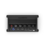
Garmin GPSMAP® 8700 Black Box
Garmin GPSMAP® 8700 Black Box – Fully Integrated Black Box System
- Compatible with a single Garmin monitor or third-party touchscreen monitor
- Full support for the range of Garmin black box sonar products, including the GSD™ 26 CHIRP Professional Sonar Module, Panoptix™ LiveScope system and the entire Panoptix™ all-seeing sonar line (all transducers sold separately)
- Integrates internal sonar sharing, multiple black box sonars, Ultra High-Definition ClearVü and SideVü scanning sonars, autopilot, connected services, apps, engine data and more
- Pairs with external GPS 19x 10 Hz GPS and GLONASS receiver to update position and heading 10 times per second
- Preloaded worldwide basemap; compatible with BlueChart® g3 charts featuring integrated Navionics® data and Auto Guidance¹ technology
Just Add Monitors
Give your vessel tremendous capabilities and features that are fully integrated across your entire marine system. This black box system is compatible with Garmin marine monitors or third-party touchscreen monitors (sold separately), allowing you to add to your current helm configuration or build a beautiful, new fully integrated glass helm.
Build Your Fully Integrated Marine System
The GPSMAP 8700 black box allows you to add and integrate multiple sonar technologies as well as autopilot, connected services, apps, engine data and multimedia at your helm. You can also automatically sync your personal preferences and user data for all networked chartplotters across multiple helms. Everything you need can conveniently be found at your fingertips — on any touchscreen. NMEA 2000® networking and the Garmin Marine Network allow you to easily build your full marine electronics suite — from radar and autopilots to cameras, instruments and forward-looking sonar — controlled from your chartplotter and shared across multiple screens. In addition, our exclusive OneHelm™ system coordinates many third-party manufactured onboard marine products to bring full control of systems — such as digital switching, lighting, stabilization and more — to your touchscreen monitor. Connect to different kinds of engines — including select Mercury and Yamaha® models — to see RPMs, fuel flow, temperature, trim and other important information on your display. You may need additional hardware, so be sure to check with your engine manufacturer.
SKU: 010-02094-00 -
Garmin, Garmin Accessories
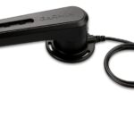
Garmin GRF™ 10 – Rudder Feedback Sensor
Garmin GRF™ 10 – Rudder Feedback Sensor
Pair this sensor with the GHP™ 20 or GHP 12 to provide rudder position feedback and to detect and avoid rudder stops while sailing or boating.
The GRF 10 uses a magnetic sensor to relay position information, eliminating friction that causes other types of sensors to wear out. The arm of the GRF 10 is connected to the rudder of the boat and relays position information through the sensor to the mariner so they know where the rudder is – giving them an added peace of mind when starting from a stopped position, docking, launching or moving at slow speeds.
Additionally, the GRF 10, allows sailors to:
- Know where the rudder is positioned without having to look back
- Make smoother maneuvers and avoid over-compensating
- Save undue wear and stress on their autopilot system by eliminating force on the rudder when it’s already stopped left or right.
SKU: 010-11829-00 -
Garmin, Garmin Accessories
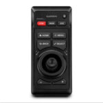
Garmin GRID 20 Remote Control
Garmin GRID 20 Remote Control – Sit Back and Take Control
- Provides intuitive, easy-to-use remote access and control of your entire Garmin marine system
- 360-degree, all-in-one joystick with a rotary knob and push-to-select button
- Enables easy chartplotter menu/setting navigation and fine control, even in the worst conditions
- 4 favorite keys can be designated to restore your system to a previously saved configuration
- Allows wired or wireless installation options
The easy-to-use GRID 20 remote input device provides intuitive remote access and control of your entire Garmin marine system. It features a 360-degree joystick with a rotary knob and push-to-select button for easy chartplotter menu/setting navigation and fine control, even in the worst conditions. You can designate 4 favourite keys to restore your system to a previously saved configuration. There are also a variety of hard keys for quick access to important functions, including left and right screen switches, autopilot standby/engage and more. For peace of mind, there’s also a dedicated SOS key. Wired or wireless installation and vertical or horizontal options allow for a plug-and-play solution that is tailored to your marine system. Its small footprint makes it convenient to integrate into a busy helm between displays — or even into the arm of the captain’s chair.
What’s in the box?
- GRID 20
- Mounting hardware
- Power cable
- Documentation
SKU: 010-02011-00, 010-02011-01 -
Garmin, Garmin Accessories
Garmin GRID™ Remote Control (Garmin Remote Input Device)
Garmin GRID™ Remote Control (Garmin Remote Input Device)
Our remote input device provides full control of all GPSMAP® 8000 Glass Helm series units. Rotary knob and joystick controls provide navigation through menus and screens and allows you to seamlessly navigate between monitors at a station – all while controlling single or multiple 8000-series monitors and multifunctional displays (MFDs) with 1 device. GRID can be integrated into a captain’s chair for a low-profile controlling solution.
What’s in the box?
- GRID (Garmin Remote Input Device)
- Mounting hardware
- Power cable
- Network cable (6 ft)
- Documentation
Installation Instructions
SKU: 010-01024-00 -
Garmin, Garmin Sonar & Transducers, Sanctuary Cove
Garmin GSD™ 24 Advanced Sonar Module
Garmin GSD™ 24 Advanced Sonar Module
The GSD 24 features a vastly improved digital sonar design for superior target definition and deep-water performance.
Get the Whole Picture
With up to 2,000 Watts of transmit power and a high-dynamic range receiver, the GSD 24 brings high-definition imaging to your compatible Garmin chartplotter. The system is dual frequency (50/200 kHz) capable and offers selectable transmit power (600 W, 1 kW and 2 kW, depending on transducer) for pin-point accuracy at depths of up to 5,000 ft (1,500 m). So whether you’re out sport fishing or just keeping an eye on hazardous terrain and reef structures beneath your boat, you’ll see a clearer picture with enhanced separation of images and deeper bottom detection.
Plug and Play
Thanks to the easy connectivity of the Garmin Marine Network, installation of the GSD 24 is a snap. Once connected, your sonar data will be shared on any compatible chartplotter on the network. Plus, the network’s high-speed connections ensure that you get ultra-fast screen updates with minimal delay.
SKU: 010-00957-00 -
Garmin, Garmin Sonar & Transducers, Sanctuary Cove
Garmin GSD™ 25 Premium CHIRP and Scanning Sonar Module
-10% Garmin, Garmin Sonar & Transducers, Sanctuary Cove
Garmin GSD™ 25 Premium CHIRP and Scanning Sonar Module
Garmin GSD™ 25 Premium CHIRP and Scanning Sonar Module
- Premium remote network sonar solution
- Includes true dual-channel 1 kW CHIRP, plus CHIRP SideVü and ClearVü scanning sonar for the clearest images on the water (transducers sold separately)
- Provides serious sport fishers outstanding fishfinding and bottom tracking capabilities
- Helps distinguish between small and closely spaced fish at key fishing depths
- Depth capability to 5,000 feet
The GSD 25 premium sonar module is a remote network solution that provides outstanding fishfinding and bottom tracking capabilities. It offers dual-channel 1 kW CHIRP, plus Garmin CHIRP ClearVü™ and Garmin CHIRP SideVü™ sonar scanning for the clearest scanning images on the water. The images sent to your compatible Garmin chartplotter have target details so clear and precise, you can actually distinguish between small and closely spaced fish at key fishing depths all the way down to 5,000 feet.
True Dual-Channel 1 kW CHIRP
CHIRP is the most sophisticated sonar technology available for use by the fishing and boating public. CHIRP is an acronym for Compressed High-Intensity Radiated Pulse. What it means to you is much better target resolution, clarity and crispness than any other sonar system. Having Garmin true dual 1 kW CHIRP as your traditional sonar allows you to adjust CHIRP frequencies to low/medium, low/high, medium/high to further optimize your sonar performance. Transducer sold separately.
Clearest Scanning Sonar Images on the Water
Adding CHIRP technology to ClearVü and SideVü scanning sonar further enhances the resolution, target separation and clarity of the sonar images of fish and structure that pass below and to the sides of your boat. Built-in to our new GPSMAP xsv combos and GSD 25 Premium Sonar Module, it uses 1 transducer for traditional CHIRP HD-ID sonar and CHIRP ClearVü and SideVü scanning sonar. Transducer sold separately.
SKU: 010-01159-00 -
Garmin, Garmin Sonar & Transducers, Sanctuary Cove
Garmin GSD™ 28 Sonar Module
Garmin GSD™ 28 Sonar Module – THE DEPTHS. REVEALED.
See what’s down there. Catch what’s down there. Take your sport fishing to extreme depths with a high-powered sonar module with the features you need to improve your chances for success.
 ENGINEERED FOR OFFSHORE SPORT FISHING
 SEE SONAR FASTER WITH GARMIN RAPIDRETURN™ TECHNOLOGY
 CRISP AND CLEAR FISH TARGETS WITH xCHIRP TECHNOLOGY
 EXCELLENT TARGET SEPARATION WITH xCHIRP TECHNOLOGY1
 GREATLY REDUCE WAVE AND SWELL FROM BOTTOM RETURNS WITH HEAVE COMPENSATION2
WHAT YOU’LL LOVE
GARMIN RAPIDRETURN SONAR
This high-performance technology provides our fastest deep-water scrolling sonar with 2 to 6 times the ping rate1 of our GSD™ 26 sonar. This allows captains to make fast and informed decisions based on what is below their boats.
XCHIRP TECHNOLOGY
Easily distinguish bait from sport fish with our clearest traditional sonar fish arches and excellent target separation. Get smooth bottom returns and precise targeting at extreme depths1.
HEAVE COMPENSATION
When the seas get rough, use the MSC™ 10 external satellite compass (sold separately) to greatly reduce wave and swell from your sonar returns.
SUPERCHARGED SONAR
COMPATIBILITY
 TRANSDUCER SUPPORT: This sonar module is compatible with a wide range of Garmin and AIRMAR® transducers (sold separately).
 RETROFITTING: The GSD 28 module is ideal for retrofitting to boats with existing bare wire transducers.
PERFORMANCE
 SONAR POWER: GSD 28 can output 300 watts to 3 kW at extreme depths1.
 CHIRP SUPPORT: The module supports dual-channel CHIRP (up to 3 kW per channel).
 OPERATION RANGE: The GSD 28 sonar module can operate in the 25 to 250 kHz frequency range1. BUILT TO LAST: GSD 28 is rated for harsh marine environments and water-resistance with an IPX7 rating.
What’s in the box
- GSD 28
- Power cable
- Garmin BlueNet™ marine network cable (1,8 m/6 ft) with legacy network adapter
- Field installable adapter kit for the Garmin BlueNet network
- Mounting hardware
- Documentation
View Installation Instructions
Garmin GSD 28 Sonar Module
SKU: 010-02797-00 -
Garmin, Garmin Accessories
Garmin GST 10 – Water Speed and Temperature Analog Adapter Cable 16ft (4.9m)
 Garmin, Garmin Accessories
Garmin GST 10 – Water Speed and Temperature Analog Adapter Cable 16ft (4.9m)
Garmin GST 10 – Water Speed and Temperature Analog Adapter Cable 16ft (4.9m)
With the GST 10 Water Speed and Temperature Analog Adapter aboard your vessel, you can give new life to your old gauges by making the transition from analog to digital. This simple-to-install adapter takes the data generated by traditional analog gauges and converts the data into a NMEA 2000® (5 Hz) signal so you can create or expand your network without replacing all of the equipment on your boat.
Connect to Your Network
With the Garmin GST 10 adapter, you can convert analog information provided via the compatible water-speed sensor, water-temperature sensor, or combined water-speed and water-temperature sensor (not included) on your boat to your NMEA 2000 network. The GST 10 allows you to observe water-speed and water-temperature information on compatible Garmin display devices connected to your NMEA 2000 network.
Upgrade With Ease
The NMEA 2000 analog adapters from Garmin are easy to add to any existing marine network. Once installed, the data from the adapters can be viewed via the GMI™ 20 Marine Instrument Display and other compatible Garmin devices. This easy-to-use set-up will help you bring your older dashboard into the digital age.
Installation Instructions
SKU: 010-11328-00 -
Garmin, Garmin Sonar & Transducers, Sanctuary Cove
Garmin GT12M-THF Transducer – 0 Degrees
Garmin GT12M-THF Transducer – 0 Degrees
LESS TIME FINDING. MORE TIME FISHING.
Designed for reduced drag and optimum sonar performance on midsize fishing and cruising boats, this flush-mounted, 600-watt midband CHIRP transducer clearly defines fish arches, structure and bottom depth returns on your display.

See maximum depth performance to 580m in freshwater.
Access CHIRP sonar frequency range from 85–165 kHz.

Search with beamwidths of 16–24 degrees.

Count on fast-response water temperature sensing.

Thru-hull design offers flush installation with 0-, 12- or 20-degree tilt.

Auto-ID enables simple plug-and-play operation.
See what’s happening below the water.
MIDBAND CHIRP TRADITIONAL SONAR
This 8-pin, 600-watt stainless steel thru-hull transducer features high-definition midband CHIRP sonar that clearly defines fish targets and structure down to 365m in saltwater and 580m in freshwater.
BROAD FREQUENCY RANGE
Use the perfect frequency for the waters you’re fishing. Covering the medium frequency range, this transducer pulses from 85–165 kHz, displaying a wide coverage area, crisp fish arches and accurate depth readings.

OPTIMUM PING SENSITIVITY
Offering excellent sonar sensitivity, low noise, high resolution and good separation of targets, this robust transducer makes it easier than ever to distinguish fish and structure on your compatible chartplotter display.
THRU-HULL INSTALLATION
A durable stainless steel housing and stem offer straightforward thru-hull flush mounting for minimum drag and optimum beam orientation for clear sonar returns.
AUTO-ID TECHNOLOGY
Enjoy simple plug-and-play operation with Garmin auto-identification technology — which enables the sonar to automatically configure itself to the transducer being used.
FITS VARIOUS HULL TYPES
Configurable for a wide variety of boat hull materials, including fiberglass, composite, steel, aluminum and wood, the transducer is available in a range of tilt versions to accommodate deadrise angles of 0–24 degrees without a fairing block.
SKU: 010-02867-00