-
×
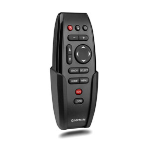 Garmin Wireless Remote Control for GPSMAP® series
1 × $169.00
Garmin Wireless Remote Control for GPSMAP® series
1 × $169.00
Subtotal: $169.00

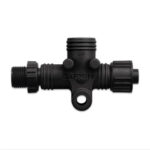
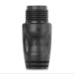
This standard male or female NMEA 2000 light cable connector provides termination resistance for one end of the backbone of the network. Each male or female connector sold separately.
| Weight | 0.1 kg |
|---|
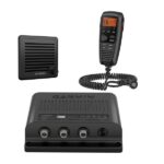
Garmin VHF 315i Marine Radio – Enjoy Reliable Communication
The 25-watt VHF 315i marine radio with Class D DSC is a modular communication solution. It provides the security of reliable communication and full NOAA weather alerts on the water by meeting the latest industry standards. It’s easy to use and integrates seamlessly into the Garmin onboard system. It has a built-in GPS receiver with connector for required external antenna. VHF 315i includes a GHS 11 handset and new active speaker to use as an intercom between up to 3 stations. It’s also equipped with a two-way 30-watt hailer system for communication with other boats or deckhands. NMEA 2000 connectivity enables easy integration with compatible chartplotters, multifunction displays and convenient software updates. Simplified handset connectors and an uncomplicated, easy-to-use interface allow you to get your radio set up quickly, so you can get back out on the water and start communicating.
Specs
In the Box
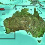
Garmin BlueChart g2 Vision – Northern and Western Australia [Garmin Part Number: 010-C0754-00] – RRP $399
Get a fresh perspective when you take to the water with BlueChart® g2 Vision®. With BlueChart g2 Vision data, you’ll get detailed marine cartography that provides convenient viewing of nautical content and other premium features. BlueChart g2 Vision allows you to see your vessel’s precise, on-chart position in relation to naviads, coastal features, anchorages, obstructions, waterways, restricted areas and more. You will also have access to detailed mapping capabilities that include Safety Shading, Fishing Charts, smooth data transition between zoom levels, harmonious transition across chart borders, and reduction of chart discontinuities. Premium features include 3-D perspective above and below the waterline, Auto Guidance, high-resolution imagery, and “real picture” aerial photos of ports, harbours, marinas, waterways, landmarks and other points of interest. It’s the most realistic mapping display Garmin has ever offered.
Detailed coverage of the Northern and Western coasts of Australia from Mackay to Esperance (VPC021R). Also includes detailed coverage of Perth, Geraldton, Broome, Darwin, the Gulf of Carpentaria, and the northern Great Barrier Reef (if another region is required please contact us for availability).
THIS IS SUITABLE FOR CURRENT MODEL GARMIN GPSMAP 7407xsv, GPSMAP 7408xsv, GPSMAP 7410xsv, GPSMAP 7412xsv, echoMAP 75dv, echoMAP 75sv & echoMAP 95sv SOUNDER/GPS COMBO UNITS, PLEASE SEE RELATED PRODUCTS OR ASK FOR FURTHER INFORMATION.
WARRANTY:
We are an authorised Australian Garmin retailer, as such Full Australian Manufacturers Warranty is applicable for this item. Please note if a Garmin unit is purchased overseas or from a non-authorised Garmin retailer you may not receive warranty coverage in Australia.
*Specifications from suppliers’ information. Actual depth capabilities depend on transducer installation, bottom type & water conditions. All sonars typically read deeper in freshwater than in saltwater. Images for display purposes only.
Get on fish faster, and stay on the water with the most powerful, most efficient trolling motor available1 — and it’s quiet, too.
![]()
Force is more efficient at 24 V than the competition’s 36 V system. No lie.
![]()
Wirelessly connect to your Garmin chartplotter, and open up a world of possibilities.
![]()
It comes with sonar built in, too? That’s just too good to be true.
![]()
All the control of a cable-steered pedal without the cable.
![]()
Just point the handheld remote where you want to go, and Force will take you there.
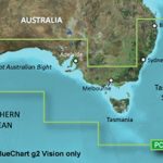
Garmin BlueChart g2 Vision – Southern Australia [Garmin Part Number: 010-C0753-00] – RRP $399
Get a fresh perspective when you take to the water with BlueChart® g2 Vision®. With BlueChart g2 Vision data, you’ll get detailed marine cartography that provides convenient viewing of nautical content and other premium features. BlueChart g2 Vision allows you to see your vessel’s precise, on-chart position in relation to naviads, coastal features, anchorages, obstructions, waterways, restricted areas and more. You will also have access to detailed mapping capabilities that include Safety Shading, Fishing Charts, smooth data transition between zoom levels, harmonious transition across chart borders, and reduction of chart discontinuities. Premium features include 3-D perspective above and below the waterline, Auto Guidance, high-resolution imagery, and “real picture” aerial photos of ports, harbours, marinas, waterways, landmarks and other points of interest. It’s the most realistic mapping display Garmin has ever offered.
Detailed coverage of the Southern coast of Australia from Geraldton to Brisbane (VPC020R). Also includes detailed coverage of Perth, the Great Australian Bight, Adelaide, Melbourne, Tasmania, Sydney, and Norfolk Island. (if another region is required please contact us for availability).
THIS IS SUITABLE FOR CURRENT MODEL GARMIN GPSMAP 7407xsv, GPSMAP 7408xsv, GPSMAP 7410xsv, GPSMAP 7412xsv, echoMAP 75dv, echoMAP 75sv & echoMAP 95sv SOUNDER/GPS COMBO UNITS, PLEASE SEE RELATED PRODUCTS OR ASK FOR FURTHER INFORMATION.
WARRANTY:
We are an authorised Australian Garmin retailer, as such Full Australian Manufacturers Warranty is applicable for this item. Please note if a Garmin unit is purchased overseas or from a non-authorised Garmin retailer you may not receive warranty coverage in Australia.
*Specifications from suppliers’ information. Actual depth capabilities depend on transducer installation, bottom type & water conditions. All sonars typically read deeper in freshwater than in saltwater. Images for display purposes only.