Subtotal: $35.00

ICOM HM-228 Speaker Microphone
・Equipped with 8-position rotary clip
・Compact type
| Weight | 0.2 kg |
|---|
| Connector information | 1 pin 4 poles |
|---|---|
| Cable Length | 380 mm; 15.0 in (with coiled cable) |
| Waterproof | IPX7 |
| Weight | 96 g |
Related products
-
Audio, GME, Marine Electronics, VHF & AIS
GME BCV008 – 12V Vehicle Charger suit GX850 DSC Handheld VHF
 Audio, GME, Marine Electronics, VHF & AIS
GME BCV008 – 12V Vehicle Charger suit GX850 DSC Handheld VHF
GME BCV008 – 12V Vehicle Charger suit GX850 DSC Handheld VHF
For over 60 years GME has designed and manufactured an extensive range of high quality accessories to suit a wide variety of applications. From 4WDing to Boating and Fishing, GME has a genuine accessory to meet every need. The BCV008 is a 12V DC Vehicle Charger to suit the GX850W.
Key Features
- 12V DC Vehicle Charger to Suit GX850W
In the box
- Charger Only
SKU: GME BCV008 -
Garmin, Garmin Accessories, Marine Electronics
Garmin BlueChart g3 Vision – East Coast of Australia
-8%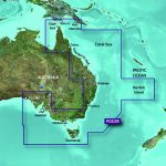 Garmin, Garmin Accessories, Marine Electronics
Garmin BlueChart g3 Vision – East Coast of Australia
### GARMIN SALE – ONLINE ONLY DEAL – WHILE STOCKS LAST – MUST END###
Garmin BlueChart g2 Vision – East Coast of Australia [Garmin Part Number: 010-C0756-00] – RRP $399
Get a fresh perspective when you take to the water with BlueChart® g2 Vision®. With BlueChart g2 Vision data, you’ll get detailed marine cartography that provides convenient viewing of nautical content and other premium features. BlueChart g2 Vision allows you to see your vessel’s precise, on-chart position in relation to naviads, coastal features, anchorages, obstructions, waterways, restricted areas and more. You will also have access to detailed mapping capabilities that include Safety Shading, Fishing Charts, smooth data transition between zoom levels, harmonious transition across chart borders, and reduction of chart discontinuities. Premium features include 3-D perspective above and below the waterline, Auto Guidance, high-resolution imagery, and “real picture” aerial photos of ports, harbours, marinas, waterways, landmarks and other points of interest. It’s the most realistic mapping display Garmin has ever offered.
Detailed coverage of the Eastern coast of Australia from Mornington Island to Fowlers Bay (VPC022R). Also includes detailed coverage of Cape York, the Great Barrier Reef, Brisbane, Sydney, Melbourne, Adelaide, Tasmania, and Norfolk Island (if another region is required please contact us for availability).
THIS IS SUITABLE FOR CURRENT MODEL GARMIN GPSMAP 7407xsv, GPSMAP 7408xsv, GPSMAP 7410xsv, GPSMAP 7412xsv, echoMAP 75dv, echoMAP 75sv & echoMAP 95sv SOUNDER/GPS COMBO UNITS, PLEASE SEE RELATED PRODUCTS OR ASK FOR FURTHER INFORMATION.
WARRANTY:
We are an authorised Australian Garmin retailer, as such Full Australian Manufacturers Warranty is applicable for this item. Please note if a Garmin unit is purchased overseas or from a non-authorised Garmin retailer you may not receive warranty coverage in Australia.*Specifications from suppliers’ information. Actual depth capabilities depend on transducer installation, bottom type & water conditions. All sonars typically read deeper in freshwater than in saltwater. Images for display purposes only.
SKU: 010-C0756-00 -
Lowrance, Lowrance VHF & AIS, Marine Electronics, VHF & AIS
Lowrance Link-9 DSC AIS-RX Marine Radio
-10%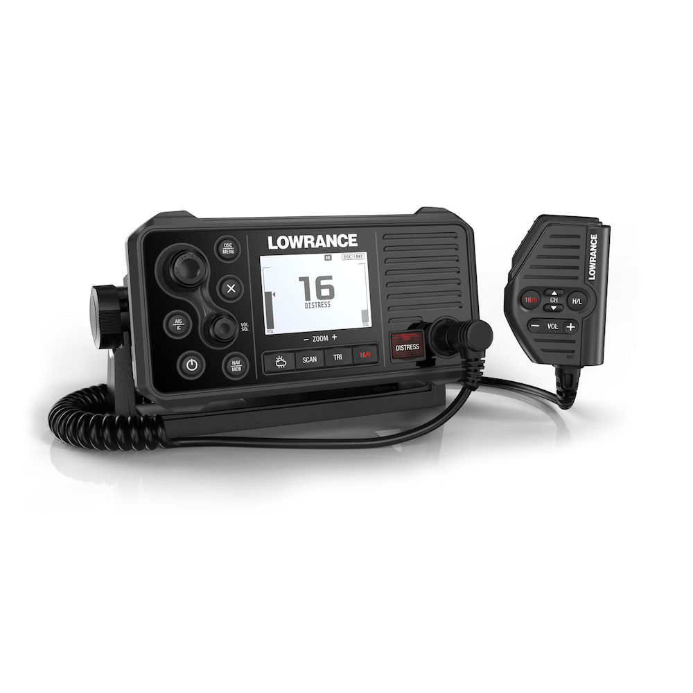 Lowrance, Lowrance VHF & AIS, Marine Electronics, VHF & AIS
Lowrance Link-9 DSC AIS-RX Marine Radio
GPS 4-Ways
With the integrated GPS receiver the Link-9 has four ways to ensure you have a GPS fix in the event of an emergency – built-in antenna, SMA connector for GPS-500 antenna, NMEA 0183 for chartplotter GPS and NMEA 2000® for network antenna connection.Built-in AIS
A dual-channel AIS receiver monitors the position of nearby AIS-equipped vessels, helping you to avoid collisions in crowded harbours and waterways. AIS information can be viewed on the Link-9’s built-in screen, or overlaid on your chart or radar screen through a compatible multifunction display.Remote Mountable Fist Mic
The Link-9’s removable fist mic can be connected to the front or rear of the radio – optional extension cable allows the radio and mic to be mounted separately. This offers a simple and cost-effective solution for any mounting location, with no cable clutter.Easier Front-Mount Installation
Link-9 features easily removable top and bottom bezels which reveal mounting holes allowing the same style of mounting from the front that is featured on Lowrance MFDs.Navigation Mode
Press the NAV button on the Link-9 to turn it into a navigational instrument displaying your Speed and Course. Link-9 also contains a Man Overboard (MOB) function, hold down the NAV/MOB button to drop a waypoint on your current location and the Link-9 will enter MOB mode to show you how far away you are and where you need to steer to get back to the person in the water. The MOB waypoint is also transmitted over NMEA 2000 to the rest of your network.Details:
-
- Class D DSC fixed mount VHF transceiver
-
- Internal GPS Antenna
-
- Six-button, backlit fist mic with optional remote mounting
-
- Built-in dual-channel AIS receiver with AIS plot functionality
-
- New front mountable mechanical design for easy installation
-
- Seamless integration with a wider Lowrance system through NMEA 2000® and 0183
-
- Large screen with intuitive user interface
-
- 25 W / 1 W transmission power
-
- Extra large, high resolution LCD display
-
- MOB feature
-
- Track Your Buddy option
-
- Dual Watch / tri watch and all scan functions
-
- PA/Hailer horn output with Listen Back Feature
-
- 10 weather channel
-
- 20 user programmable names with MMSI
-
- Fully waterproof
- New Industrial Design to align with style of Lowrance MFD’s
SKU: 000-14472-001 -
-
Lowrance, Lowrance Sonar & Transducers, Marine Electronics, Simrad, Simrad Sonar & Transducers, Transducers
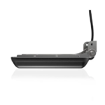
Lowrance Active Imaging 3-in-1 Transducer
-8% Lowrance, Lowrance Sonar & Transducers, Marine Electronics, Simrad, Simrad Sonar & Transducers, Transducers
Lowrance Active Imaging 3-in-1 Transducer
See structure and cover with a new level of refined detail and at a range unmatched by any other structure imaging technology with the Lowrance Active Imaging 3-in-1 Transducer featuring CHIRP, SideScan and DownScan with FishReveal™. The high-level clarity, target separation and detail of Active Imaging will help you find more fish by making it easier to quickly identify fish-holding structures like rockpiles, standing timber, weed beds, ditches and drop-offs – all at a greater distance from your boat. Get the best of CHIRP sonar and DownScan on one screen with the exclusive FishReveal™ Smart Target view that helps you easily recognize fish from structure and cover on high-detailed DownScan images. Giving you the best clarity and range available, the new Lowrance Active Imaging 3-in-1 transducer is going to give you the imaging clarity like Lowrance’s 3D module without the price tag and separate module. This is all plug and play into any Lowrance HDS Carbon, HDS LIVE, Elite TI and Elite Ti2.
 Key Features
- More refined detail and better range than any other imaging technology
- Active Imaging 3-in-1 transducer with Lowrance CHIRP, SideScan and DownScan
- Easier target identification with FishReveal™ Smart Target View
- Supports Medium and High CHIRP (83/200kHz) + 455/800kHz frequencies
- Compatible with Lowrance HDS LIVE, HDS Carbon, Elite Ti2 displays
Active Imaging Transducers
- Active Imaging is a new scanning sonar technology that provides incredibly detailed, high-resolution imaging sonar without sacrificing any range
- Active Imaging transducers accomplish this by better directing the SideScan beams which increases resolution and improves range performance
Active Imaging is available in two models
- Active Imaging 3-IN-1 combines the new Active Imaging scanning sonar with a traditional Medium/High CHIRP sonar element for easy single transducer installation
- Active Imaging operates at 800kHz or 455kHz with maximum ranges of 150ft (800kHz) or 300ft (455kHz)
Active imaging Technology
- Active Imaging utilizes the latest techniques in sonar signal generation
- Active Imaging transducers are constructed of a polymer that reacts to sound waves more closely to water. This ensures that no sonar signal is lost during transmit or receive
- Active Imaging transducers include separate sonar elements for SideScan transmit and receive Separating transmit and receive allows Active Imaging to have an incredibly fast ping speed (Ping speed directly correlates to image resolution). Additionally, these separate elements focus more of the sonar signal outwardly, increasing the sonar signal to the sides and leading to better range performance
High detail or seeing far
- High-resolution IPS screens of NSS evo3 and HDS Live show the full image, allowing the user to see the entire underwater environment
- Active Imaging 3-IN-1 transducers combine industry-leading CHIRP sonar with new Active Imaging Side and Down views giving users total coverage with award winning sonar
- Active Imaging transducers do not require any modules or extra hardware for use with next-generation displays
Environmental
Operating temperature -15°C to +55°C (+5°F to +131°F) Storage temperature -30°C to +70°C (-22°F to +158°F) Physical
Cable length 7.6 m (25 ft) Mounting options Transom, flush step, and jackplate mounting Connector 9 pin Transducer
Output SideScan imaging, DownScan imaging and temperature Frequency 455 kHz and 800 kHz Max depth DownScan: 91 m (300 ft): SideScan: 91 m (300 ft) side range at 455 kHz, 46 m (150ft) side range at 800 kHz Operating speed DownScan and SideScan: 9 knots (10 mph) SKU: 000-14489-001