-
×
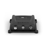 Garmin AIS™ 800 Blackbox Transceiver
1 × $1,739.00
Garmin AIS™ 800 Blackbox Transceiver
1 × $1,739.00
Subtotal: $1,739.00

・Equipped with 8-position rotary clip
・Compact type
| Weight | 0.2 kg |
|---|
| Connector information | 1 pin 4 poles |
|---|---|
| Cable Length | 380 mm; 15.0 in (with coiled cable) |
| Waterproof | IPX7 |
| Weight | 96 g |
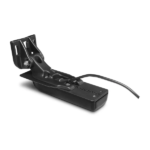
The GT54UHD-TM transducer provides image details so clear and precise, you can actually see fish hanging just off branches of submerged trees, brush and rocks. You can see size differences between bigger and smaller fish and even see individual fish swimming in bait balls. You get the highest resolution ClearVü and SideVü scanning sonar images available plus amazingly clear high wide CHIRP traditional sonar1 — all in one transducer.
Ultra High-Definition scanning sonar provides extended range and depth performance. It shows you incredibly detailed images of fish and structure up to 200’ below your boat with 800 kHz ClearVü, while two SideVü sonar frequency settings (455/1200 kHz) provide options for extended range of up to 500’. It’s easy to install with included transom and trolling motor mounts so you can start fishing faster.
¹For use with GPSMAP® 8400xsv/8600xsv chartplotter/sonar combos
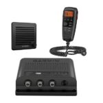
Garmin VHF 315i Marine Radio – Enjoy Reliable Communication
The 25-watt VHF 315i marine radio with Class D DSC is a modular communication solution. It provides the security of reliable communication and full NOAA weather alerts on the water by meeting the latest industry standards. It’s easy to use and integrates seamlessly into the Garmin onboard system. It has a built-in GPS receiver with connector for required external antenna. VHF 315i includes a GHS 11 handset and new active speaker to use as an intercom between up to 3 stations. It’s also equipped with a two-way 30-watt hailer system for communication with other boats or deckhands. NMEA 2000 connectivity enables easy integration with compatible chartplotters, multifunction displays and convenient software updates. Simplified handset connectors and an uncomplicated, easy-to-use interface allow you to get your radio set up quickly, so you can get back out on the water and start communicating.
Specs
In the Box
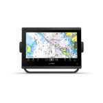
With its sleek design, powerful processing and upgraded IPS display, this advanced 9″ chartplotter integrates seamlessly into your Garmin marine system.
![]()
Easily integrate with more engines.
![]()
Connect to compatible third-party devices with OneHelm™ digital switching.
![]()
Easily build your marine system using the best of network connectivity.
![]()
Compatible with premium maps and charts1 for the best in Garmin navigation.
![]()
See below your boat with built-in sonar capabilities
![]()
Manage your marine experience from nearly anywhere1.
GPS 4-Ways
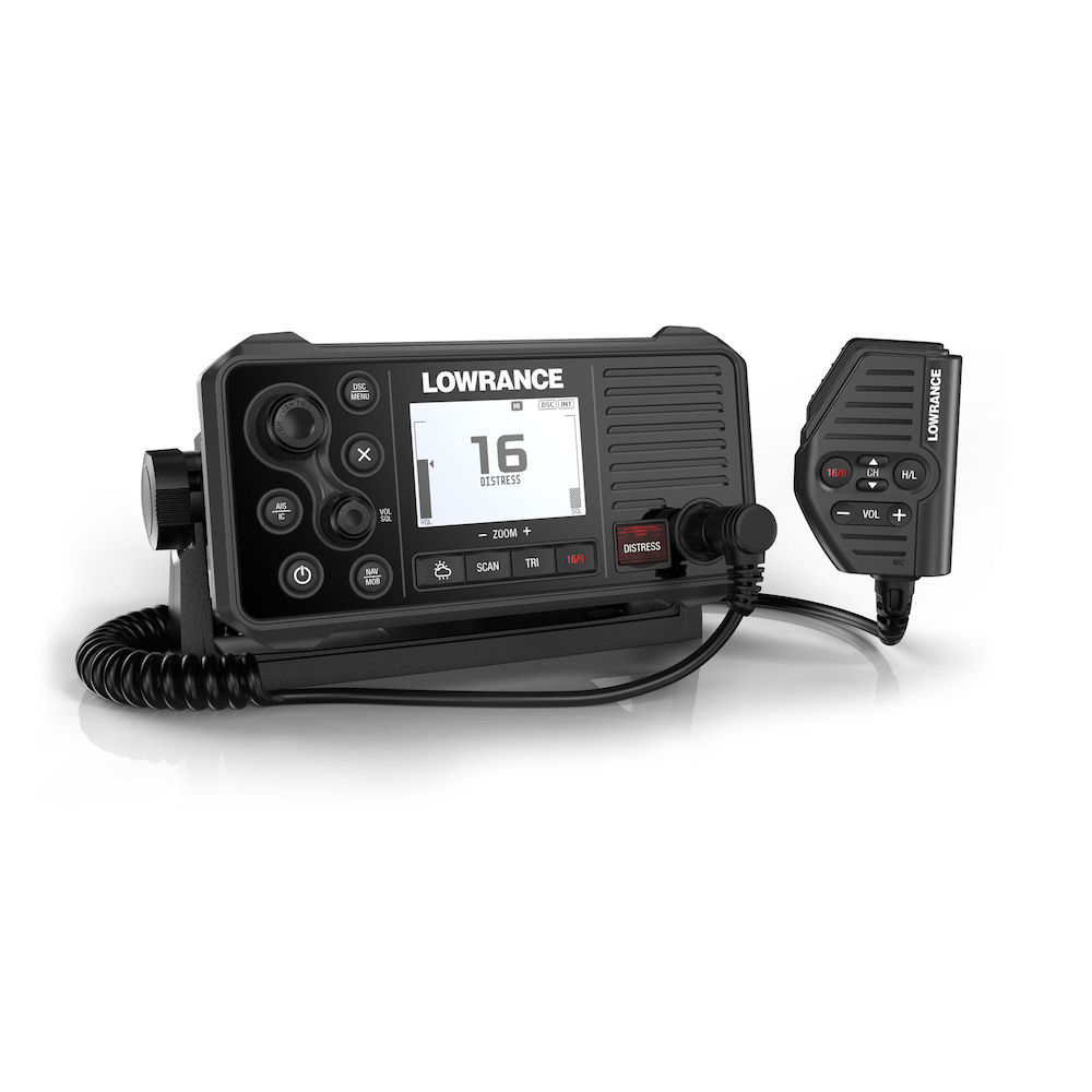
With the integrated GPS receiver the Link-9 has four ways to ensure you have a GPS fix in the event of an emergency – built-in antenna, SMA connector for GPS-500 antenna, NMEA 0183 for chartplotter GPS and NMEA 2000® for network antenna connection.
Built-in AIS
A dual-channel AIS receiver monitors the position of nearby AIS-equipped vessels, helping you to avoid collisions in crowded harbours and waterways. AIS information can be viewed on the Link-9’s built-in screen, or overlaid on your chart or radar screen through a compatible multifunction display.
Remote Mountable Fist Mic
The Link-9’s removable fist mic can be connected to the front or rear of the radio – optional extension cable allows the radio and mic to be mounted separately. This offers a simple and cost-effective solution for any mounting location, with no cable clutter.
Easier Front-Mount Installation
Link-9 features easily removable top and bottom bezels which reveal mounting holes allowing the same style of mounting from the front that is featured on Lowrance MFDs.
Navigation Mode
Press the NAV button on the Link-9 to turn it into a navigational instrument displaying your Speed and Course. Link-9 also contains a Man Overboard (MOB) function, hold down the NAV/MOB button to drop a waypoint on your current location and the Link-9 will enter MOB mode to show you how far away you are and where you need to steer to get back to the person in the water. The MOB waypoint is also transmitted over NMEA 2000 to the rest of your network.
Details: