-
×
 Garmin GPSMAP 953xsv
1 × $2,375.00
Garmin GPSMAP 953xsv
1 × $2,375.00
Subtotal: $2,375.00

・Equipped with 8-position rotary clip
・Compact type
| Weight | 0.2 kg |
|---|
| Connector information | 1 pin 4 poles |
|---|---|
| Cable Length | 380 mm; 15.0 in (with coiled cable) |
| Waterproof | IPX7 |
| Weight | 96 g |
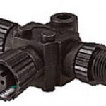
Lowrance/Simrad N2K-T-RD – NMEA 2000 Micro-C T-connector for connection of an additional network device (Part No.: 000-0119-79)
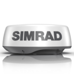
A cost-effective way to increase situational awareness and collision avoidance, HALO20 is a compact dome radar with pulse compression technology that detects collision hazards and other targets in close and up to 24 nautical miles away. With its small footprint and low profile, HALO20 is the perfect radar solution for budget-conscious boaters with small sportfishing vessels and dayboats.
Extend your view from the bow of your boat out to 24 nautical miles with pulse-compression radar technology that not only delivers a powerful mix of short and long-range detection, but provides precise target definition with minimal clutter.
HALO20 radar delivers a comprehensive range of features to enhance your situational awareness and on-water safety. Monitor selected collision hazards with MARPA target tracking, tracking up to 10 targets, or 20 in dual range. Whether you’re navigating through crowded waterways or contending with poor visibility, HALO20 radar cuts through the clutter to give you a clear and current picture of your surroundings.
HALO20 Radar wakes instantly from its low-power standby mode, delivering radar coverage exactly when and where you need it. Even if your HALO20 radar is completely powered down start-up is a matter of seconds, not minutes like traditional pulse radar.
Harbour, Offshore, Weather and custom modes tune HALO20 Radar’s advanced signal processing to help ensure that targets can be seen vividly – even in the toughest environmental conditions.
 10m cable for HALO Dome Radar / Nemesis™
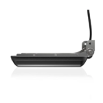
See structure and cover with a new level of refined detail and at a range unmatched by any other structure imaging technology with the Lowrance Active Imaging 3-in-1 Transducer featuring CHIRP, SideScan and DownScan with FishReveal™. The high-level clarity, target separation and detail of Active Imaging will help you find more fish by making it easier to quickly identify fish-holding structures like rockpiles, standing timber, weed beds, ditches and drop-offs – all at a greater distance from your boat. Get the best of CHIRP sonar and DownScan on one screen with the exclusive FishReveal™ Smart Target view that helps you easily recognize fish from structure and cover on high-detailed DownScan images. Giving you the best clarity and range available, the new Lowrance Active Imaging 3-in-1 transducer is going to give you the imaging clarity like Lowrance’s 3D module without the price tag and separate module. This is all plug and play into any Lowrance HDS Carbon, HDS LIVE, Elite TI and Elite Ti2.
 Key Features
| Operating temperature | -15°C to +55°C (+5°F to +131°F) |
| Storage temperature | -30°C to +70°C (-22°F to +158°F) |
| Cable length | 7.6 m (25 ft) |
| Mounting options | Transom, flush step, and jackplate mounting |
| Connector | 9 pin |
| Output | SideScan imaging, DownScan imaging and temperature |
| Frequency | 455 kHz and 800 kHz |
| Max depth | DownScan: 91 m (300 ft): SideScan: 91 m (300 ft) side range at 455 kHz, 46 m (150ft) side range at 800 kHz |
| Operating speed | DownScan and SideScan: 9 knots (10 mph) |
### GARMIN SALE – ONLINE ONLY DEAL – WHILE STOCKS LAST – MUST END###
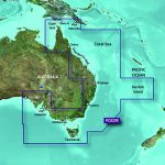
Garmin BlueChart g2 Vision – East Coast of Australia [Garmin Part Number: 010-C0756-00] – RRP $399
Get a fresh perspective when you take to the water with BlueChart® g2 Vision®. With BlueChart g2 Vision data, you’ll get detailed marine cartography that provides convenient viewing of nautical content and other premium features. BlueChart g2 Vision allows you to see your vessel’s precise, on-chart position in relation to naviads, coastal features, anchorages, obstructions, waterways, restricted areas and more. You will also have access to detailed mapping capabilities that include Safety Shading, Fishing Charts, smooth data transition between zoom levels, harmonious transition across chart borders, and reduction of chart discontinuities. Premium features include 3-D perspective above and below the waterline, Auto Guidance, high-resolution imagery, and “real picture” aerial photos of ports, harbours, marinas, waterways, landmarks and other points of interest. It’s the most realistic mapping display Garmin has ever offered.
Detailed coverage of the Eastern coast of Australia from Mornington Island to Fowlers Bay (VPC022R). Also includes detailed coverage of Cape York, the Great Barrier Reef, Brisbane, Sydney, Melbourne, Adelaide, Tasmania, and Norfolk Island (if another region is required please contact us for availability).
THIS IS SUITABLE FOR CURRENT MODEL GARMIN GPSMAP 7407xsv, GPSMAP 7408xsv, GPSMAP 7410xsv, GPSMAP 7412xsv, echoMAP 75dv, echoMAP 75sv & echoMAP 95sv SOUNDER/GPS COMBO UNITS, PLEASE SEE RELATED PRODUCTS OR ASK FOR FURTHER INFORMATION.
WARRANTY:
We are an authorised Australian Garmin retailer, as such Full Australian Manufacturers Warranty is applicable for this item. Please note if a Garmin unit is purchased overseas or from a non-authorised Garmin retailer you may not receive warranty coverage in Australia.
*Specifications from suppliers’ information. Actual depth capabilities depend on transducer installation, bottom type & water conditions. All sonars typically read deeper in freshwater than in saltwater. Images for display purposes only.