Garmin Flotation Lanyard
Keep your device secure and close-at-hand on the water with this neoprene flotation lanyard, featuring a quick-release connector.
| Weight | 0.1 kg |
|---|
You may also like…
-
Garmin, Sanctuary Cove
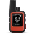
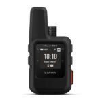
Garmin inReach mini 2 Flame Red
Garmin inReach mini 2 Flame Red – HOME IS CLOSER THAN YOU THINK
This compact satellite communicator1 helps you keep home with you when you’re off the grid — adding peace of mind to every adventure, without adding weight to your pack.

Global satellite coverage keeps you connected when mobile phones can’t.

In an emergency, send an interactive SOS message to our coordination centre.

You can still connect to the ones who matter, even without mobile phone coverage.

With TracBack® routing, find your way back if you happen to get lost.

Expand the capabilities of your inReach device by using the Garmin Explore™ app.

Stay on adventures longer with up to 14 days of battery life in 10-minute tracking mode.
SKU: 010-02602-00 -
Garmin, Sanctuary Cove
Garmin inReach mini 2 Black
Garmin inReach mini 2 Black – HOME IS CLOSER THAN YOU THINK
This compact satellite communicator1 helps you keep home with you when you’re off the grid — adding peace of mind to every adventure, without adding weight to your pack.
Global satellite coverage keeps you connected when mobile phones can’t.
In an emergency, send an interactive SOS message to our coordination centre.
You can still connect to the ones who matter, even without mobile phone coverage.
With TracBack® routing, find your way back if you happen to get lost.
Expand the capabilities of your inReach device by using the Garmin Explore™ app.
Stay on adventures longer with up to 14 days of battery life in 10-minute tracking mode.
SKU: 010-02602-01
Related products
-
Garmin, Garmin Accessories
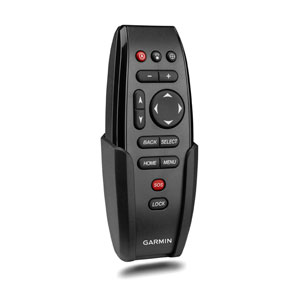
Garmin Wireless Remote Control for GPSMAP® series
Garmin Wireless Remote Control for GPSMAP® series
Use this portable keyed remote to wirelessly control your compatible GPSMAP® series chartplotter. Includes cradle and lanyard. Two AAA batteries are required (not included).
WHAT’S IN THE BOX:
- Wireless Remote
- Documentation
Instructions
SKU: 010-10878-10 -
Garmin, Garmin Trolling Motors, Sanctuary Cove
Garmin Force® 57″ Trolling Motor
Garmin Force® 57″ Trolling Motor – FISH WITH FORCE
Get on fish faster, and stay on the water with the most powerful, most efficient trolling motor available1 — and it’s quiet, too.

Force is more efficient at 24 V than the competition’s 36 V system. No lie.

Wirelessly connect to your Garmin chartplotter, and open up a world of possibilities.

It comes with sonar built in, too? That’s just too good to be true.

All the control of a cable-steered pedal without the cable.

Just point the handheld remote where you want to go, and Force will take you there.
SKU: 010-02025-00 -
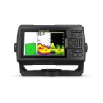
Garmin, Garmin Fishfinder, Sanctuary Cove
Garmin STRIKER Vivid 5cv with GT20-TM Transducer
Garmin STRIKER Vivid 5cv with GT20-TM Transducer – THE CHOICE IS YOURS
See fish and structure in maximum detail when you pick your display colour, your location and your sonar for your day on the water with the STRIKER Vivid 5cv fishfinder with transducer.

The sonar colour you pick says a lot about your fishing style. Good thing there are 7 new vivid options.

What a view. Use the included transducer to get CHIRP traditional and ClearVü sonars.

Never lose a hot spot again. Use waypoint marking to find your way back.
What’s under the water’s surface looks pretty good as 1′ contours, just saying.
SKU: 010-02551-01 -
Garmin, Garmin Sonar & Transducers, Sanctuary Cove
Airmar TM185M – Chirp-ready Transom Mount Transducer
-18%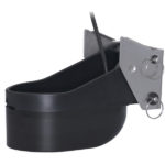 Garmin, Garmin Sonar & Transducers, Sanctuary Cove
Airmar TM185M – Chirp-ready Transom Mount Transducer
Airmar TM185M – Chirp-ready Transom Mount Transducer
Airmar’s TM185M is a transom-mounted, Chirp-ready transducer designed for offshore fishing and freshwater anglers spending their time in shallow to mid-range depths. The medium frequency delivers the right combination of coverage under the boat, extended depth range, and the ability to produce clean and accurate target and structure returns in mid to deeper water. Medium frequency also provides excellent shallow to mid-depth performance, bottom detail, and fish-target separation. Operating at a frequency range of 85 to 135 kHz, this transducer reveals fish at medium depths down to 457 m (1500′) and gives ultra-clear target resolution.
SKU: 010-12810-20