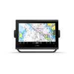
Garmin ECHOMAP Ultra 2 Chartplotter – 16 inch 165sv
Price Match
$5,599.00 $5,999.00
ECHOMAP™ Ultra 2 16″ Chartplotters
165sv with GT56UHD-TM transducer;
Includes Garmin Navionics+™ Australia & New Zealand mapping
SEE BIGGER CATCHES ON A BIGGER SCREEN
Designed with the serious angler in mind, this 16″ chartplotter with a full HD resolution display brings the ultimate in big-picture clarity, brightness and readability to your navigation mapping and sonar returns. It support Garmin Navionics+™ and Garmin Navionics Vision+™ mapping, plus there’s support for the full line of LiveScope™ sonars1 as well as Ultra High-Definition scanning sonars and CHIRP traditional sonar.

16″ TOUCHSCREEN WITH KEYED ASSIST

HDMI OUTPUT CONNECTORS FOR SCREEN SHARING

BLUETOOTH® TECHNOLOGY ENABLES VOICE CONTROL FEATURES

SUPPORTS LIVESCOPE SONAR1 AND MORE

WIRELESSLY NETWORK; SHARE SONAR, WAYPOINTS AND ROUTES2

MULTI-BAND GPS FOR SUPERIOR POSITION ACCURACY
WHAT YOU’LL LOVE
")
LIVESCOPE SONAR SUPPORT
The ECHOMAP Ultra 2 chartplotter series supports the full lineup of LiveScope live-scanning sonar products (transducers sold separately).
")
BUILT-IN UHD SONAR
Select models are bundled with a GT56 transducer that provides Garmin CHIRP traditional sonar and Ultra High-Definition ClearVü™ and SideVü™ scanning sonars for photo-like images of what’s beneath the surface.
")
PRELOADED CHARTS
Select units come with built-in Garmin Navionics+ mapping, which includes a 1-year subscription for daily updates, depth range shading and more. For added features, Garmin Navionics Vision+™ premium mapping is optionally available (sold separately).
")
HDMI OUTPUT
Use the chartplotter’s HDMI output connector to share your sonar screen with a TV or other external display.
")
VOICE CONTROL FEATURES
Built-in BLUETOOTH technology enables you to give voice commands to your chartplotter for hands-free control of such features as Force® trolling motor modes, favorite keys and sonar inputs.
")
VIVID COLOUR PALETTES
High-contrast vivid scanning sonar color palettes make it easier than ever to distinguish targets and structure.
STAY CONNECTED
WIRELESS NETWORKING
Share sonar3, waypoints and routes with another ECHOMAP Ultra 2 or UHD2 plotter on board.

MULTI-BAND GPS
Get improved position accuracy with multi-band GPS

NMEA 2000® NETWORK COMPATIBILITY
Connect to heading sensors, autopilots, Fusion-Link™ audio systems and more.

ActiveCaptain® App
Pair with the free smart-device app for software updates, screen recording, Garmin Quickdraw™ Community data and more4.

Force trolling motor
Wirelessly connect to your Force trolling motor to navigate to waypoints, draw and follow routes, and more.

SCREEN RECORDING
Use the recording feature through the ActiveCaptain app on your smartphone to share images from your chartplotter.

Bail mount with knobs
Surface mount your compatible ECHOMAP Ultra 2 chartplotter by using our bail mount with knobs; the mount tilts for optimum viewing.
See everything with the
ultra high-definition
scanning sonar system.
In the box
- ECHOMAP Ultra 165sv
- GT56UHD-TM transducer
- Power Cable
- Bail Mount
- Protective sun cover
- Trim caps
- Hardware
- Documentation
- Bail mount with knobs
- Trim caps
- 8-pin transducer to 12-pin sounder adapter cable
| Weight | 4.5 kg |
|---|
| General | |
| Dimension | 43 x 26.6 x 8 cm (16.9″ x 10.5″ x 3.14″) |
| Weight | 4.31 kg (9.5 lbs) |
| Water rating | IPX7 |
| Touchscreen | ✓ |
| Display Type | FHD, IPS |
| Display Size | 34.5 x 19.5 cm;
39.7 cm diagonal (13.6″ x 7.7″; 15.6″ diagonal) |
| Display Resolution | 1920 x 1080 pixels |
| Mounting Options | Bail or flush |
| Input | Touchscreen with Keyed Assist |
| Maps & Memory | |
| Accepts Data Cards | 2 microSD Cards |
| Waypoints | 5000 |
| Track points | 50,000 |
| Tracks | 50 saved tracks |
| Navigation Routes | 100 |
| Sensors | |
| GPS | ✓ |
| GLONASS | ✓ |
| Galileo | ✓ |
| BeiDou | ✓ |
| Has built-in receiver | ✓ |
| Receiver | 10 Hz |
| NMEA 2000 Compatible | ✓ |
| NMEA 0183 Compatible | ✓ |
| Supports WAAS | ✓ |
| Supports multi-band, multi-constellation GPS | ✓ |
| Built-in maps | |
| Built-in Auto Guidance+ | Yes (see Additional) |
| Garmin Navionics+ Inland & Coastal | Yes (see Additional) |
| Tide tables | Yes (see Additional) |
| Optional map support | |
| BlueChart g3 | ✓ |
| BlueChart g3 Vision | ✓ |
| LakeVü g3 | ✓ |
| LakeVü g3 Ultra | ✓ |
| Garmin Navionics+™ | ✓ |
| Garmin Navionics Vision+™ | ✓ |
| TOPO 100K | ✓ |
| Standard Mapping | ✓ |
| Garmin Quickdraw Contours | ✓ |
| Chartplotter Features | |
| AIS | ✓ |
| DSC | ✓ |
| Supports Fusion-Link™ compatible radios | ✓ |
| ActiveCaptain Mobile Planning Compatible | ✓ |
| Supports voice commands | ✓ |
| Sailing Features | ✓ |
| Electrical features | |
| POWER INPUT | 9 to 18 Vdc |
| Typical current draw at 12 Vdc | 3.9 A |
| Maximum current draw at 12 Vdc | 6.6 A |
| Maximum power usage at 10 Vdc | 48 W |
| Sonar Features | |
| Displays sonar | ✓ |
| Power output | 600 W |
| Traditional sonar (dual frequency/beam) | built-in (single channel CHIRP, 70/83/200 kHz, L, M, H CHIRP) |
| ClearVü | Built-in 260/455/800/1000/1200 kHz |
| SideVü | Built-in 260/455/800/1000/1200 kHz |
| Panoptix™ sonar | ✓ |
| LiveScope | ✓ |
| Connections | |
| NMEA 2000® ports | 1 |
| Video output ports | 1 HDMI |
| Garmin Marine Network Ports | 2 (large connector) |
| 12-pin transducer ports | 12-pin scanning sonar |
| BLUETOOTH® pairing | ✓ |
| ANT® (Connectivity) | ✓ |
| Garmin Wi-Fi network (local connection) | ✓ |
Related products
-
Garmin, Garmin Chartplotters, Marine Electronics, Sanctuary Cove, Sounders
Garmin GPSMAP 953xsv
Garmin GPSMAP 953xsv – GET A SHARPER VIEW FROM YOUR CONNECTED HELM
With its sleek design, powerful processing and upgraded IPS display, this advanced 9″ chartplotter integrates seamlessly into your Garmin marine system.

Easily integrate with more engines.

Connect to compatible third-party devices with OneHelm™ digital switching.

Easily build your marine system using the best of network connectivity.

Compatible with premium maps and charts1 for the best in Garmin navigation.

See below your boat with built-in sonar capabilities

Manage your marine experience from nearly anywhere1.
SKU: 010-02366-62 -
Garmin, Garmin Accessories
Garmin GLO 2 Remote GPS Sensor with Bluetooth (010-02184-01)
Garmin GLO Remote GPS Sensor with Bluetooth [Garmin Part Number: 010-01055-00] – RRP $149
Navigate with Garmin-caliber GPS data on the mobile device of your choice. GLO brings you the best of both worlds by combining GPS/GLONASS receivers with Bluetooth® technology so you can enjoy precise position information on your iPad, iPhone or Android device.
The Accuracy of GPS + GLONASS
GLO can receive position information from both the GPS and GLONASS satellite constellations, allowing it to connect to up to 24 more satellites than devices that rely on GPS alone. This allows GLO to lock on to satellites approximately 20 percent faster and remain connected even at high speed. What’s more, GLO updates its position information at 10 times per second — that’s up to 10 times more often than the GPS receivers in many mobile devices.Set It Up and Go
Using Bluetooth technology, GLO wirelessly pairs to your mobile device. Just set GLO within range of your mobile device, and in moments you’ll be receiving GLO’s position data. It has up to 12 hours of battery life to keep your position on long trips, and charging GLO between uses is easy with the included USB cable or optional 12/24 volt cigarette lighter adapter. The optional friction mount keeps the receiver safe on your dashboard and in full view of satellites.SPECIFICATIONS:
Physical & Performance
* Unit size, WxHxD: .70″ x 1.65″ x 3.04″ (1.78 x 4.19 x 7.72 cm)
* Weight: 2.12 oz (60.1 g)
* Receiver Technology: GPS+GLONASS
* WAAS: Yes
* Update Rate: 10 Hz
* Accuracy: 3 meters
* Battery Capacity: 1100mAh
* Battery Life: 12 hours
* Hot Start Time: 3–5s
* Warm Start Time: 35s
* Cold Start Time: 60sWHAT’S IN THE BOX:
* GLO receiver
* USB cable
* DocumentationWARRANTY:
We are an authorised Australian Garmin retailer, as such Full Australian Manufacturers Warranty is applicable for this item. Please note if a Garmin unit is purchased overseas or from a non-authorised Garmin retailer you may not receive warranty coverage in Australia.*Specifications from suppliers’ information. Actual depth capabilities depend on transducer installation, bottom type & water conditions. All sonars typically read deeper in freshwater than in saltwater. Images for display purposes only.
SKU: 010-02184-01 -
Garmin, Garmin Sonar & Transducers, Marine Electronics, Transducers
Garmin GT54UHD-TM Transducer – Ultra High-Definition Scanning Sonar All-in-one Transducer
-8%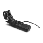 Garmin, Garmin Sonar & Transducers, Marine Electronics, Transducers
Garmin GT54UHD-TM Transducer – Ultra High-Definition Scanning Sonar All-in-one Transducer
Garmin GT54UHD-TM Transducer – Ultra High-Definition Scanning Sonar All-in-one Transducer
All-in-one Transducer
- One transducer provides the highest resolution ClearVü and SideVü scanning sonar images available and amazingly clear high wide CHIRP traditional sonar
- High wide CHIRP traditional sonar provides remarkably clear target separation and definition
- See incredibly detailed images of fish and structure up to 200’ below your boat with 800 kHz ClearVü sonar
- Two SideVü sonar frequency settings (455/1200 kHz) provide options for extended range of up to 500’
- Easy-to-install, compact, all-in-one design includes transom and trolling motor mounts
Ultra-high Clarity
The GT54UHD-TM transducer provides image details so clear and precise, you can actually see fish hanging just off branches of submerged trees, brush and rocks. You can see size differences between bigger and smaller fish and even see individual fish swimming in bait balls. You get the highest resolution ClearVü and SideVü scanning sonar images available plus amazingly clear high wide CHIRP traditional sonar1 — all in one transducer.
Ultra-high Performance
Ultra High-Definition scanning sonar provides extended range and depth performance. It shows you incredibly detailed images of fish and structure up to 200’ below your boat with 800 kHz ClearVü, while two SideVü sonar frequency settings (455/1200 kHz) provide options for extended range of up to 500’. It’s easy to install with included transom and trolling motor mounts so you can start fishing faster.
¹For use with GPSMAP® 8400xsv/8600xsv chartplotter/sonar combos
SKU: 010-12909-000 -
Garmin, Garmin Accessories, Marine Electronics
Garmin BlueChart g3 Vision – East Coast of Australia
-8%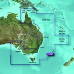 Garmin, Garmin Accessories, Marine Electronics
Garmin BlueChart g3 Vision – East Coast of Australia
### GARMIN SALE – ONLINE ONLY DEAL – WHILE STOCKS LAST – MUST END###
Garmin BlueChart g2 Vision – East Coast of Australia [Garmin Part Number: 010-C0756-00] – RRP $399
Get a fresh perspective when you take to the water with BlueChart® g2 Vision®. With BlueChart g2 Vision data, you’ll get detailed marine cartography that provides convenient viewing of nautical content and other premium features. BlueChart g2 Vision allows you to see your vessel’s precise, on-chart position in relation to naviads, coastal features, anchorages, obstructions, waterways, restricted areas and more. You will also have access to detailed mapping capabilities that include Safety Shading, Fishing Charts, smooth data transition between zoom levels, harmonious transition across chart borders, and reduction of chart discontinuities. Premium features include 3-D perspective above and below the waterline, Auto Guidance, high-resolution imagery, and “real picture” aerial photos of ports, harbours, marinas, waterways, landmarks and other points of interest. It’s the most realistic mapping display Garmin has ever offered.
Detailed coverage of the Eastern coast of Australia from Mornington Island to Fowlers Bay (VPC022R). Also includes detailed coverage of Cape York, the Great Barrier Reef, Brisbane, Sydney, Melbourne, Adelaide, Tasmania, and Norfolk Island (if another region is required please contact us for availability).
THIS IS SUITABLE FOR CURRENT MODEL GARMIN GPSMAP 7407xsv, GPSMAP 7408xsv, GPSMAP 7410xsv, GPSMAP 7412xsv, echoMAP 75dv, echoMAP 75sv & echoMAP 95sv SOUNDER/GPS COMBO UNITS, PLEASE SEE RELATED PRODUCTS OR ASK FOR FURTHER INFORMATION.
WARRANTY:
We are an authorised Australian Garmin retailer, as such Full Australian Manufacturers Warranty is applicable for this item. Please note if a Garmin unit is purchased overseas or from a non-authorised Garmin retailer you may not receive warranty coverage in Australia.*Specifications from suppliers’ information. Actual depth capabilities depend on transducer installation, bottom type & water conditions. All sonars typically read deeper in freshwater than in saltwater. Images for display purposes only.
SKU: 010-C0756-00