Garmin STRIKER 4, 4cv, and 4dv Neoprene Cover (BBB-S4C)
 Subtotal: $24.99


Garmin 4-pin Transducer Extension Cable
Connect your 4-pin transducer to your sonar unit with this 10 ft (3 m) extension cable.
| Weight | 0.5 kg |
|---|---|
| Length | 5m, 15m |
Related products
-
Garmin, Garmin VHF and AIS, Marine Electronics, VHF & AIS
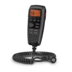
Garmin GHS™ 11i Wired VHF Handset
Garmin GHS 11i allows full function of your compatible VHF radio from a remote location. There are no complex components, just a simple design that includes soft keys, a 2” diagonal dot matrix display and a coiled cable that stretches from about 1’ to nearly 5’.
A rotary/push knob for volume, squelch and channel selection makes it easy to use with a dedicated button for access to channels 16/9. All buttons and knobs resemble those of the VHF radio.
In addition, GHS 11i features a microphone that has intercom capabilities when connected to a speaker.
Specs
- Dimensions: 2.7″ x 6.1″ x 1.6″ (6.9 x 15.4 x 4.0 cm)
- Weight: 0.7 lb. (0.3 kg)
- Operating Temperature Range: 5°F to 158°F (-15°C to 70°C)
- Water rating: IPX7
- Cable length: 1 ft. coiled (5 ft. stretched)
- Compass safe distance: 27” (70 cm)
- Display: Backlit LCD
- Built-in speaker mic: Yes
- 16/9 or 16+ channel button: Yes
- Languages: English, French, Italian, German and Spanish
In the Box
- GHS 11i
- Deck cable (10 meter)
- Microphone hanger
- Mounting hardware
- Documentation
SKU: 010-01759-01 -
EOFY, Garmin, Garmin Watches
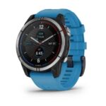
Garmin Watch Quatix 7 – Standard Edition Multisport GPS Watch
Garmin Watch Quatix 7 – Standard Edition Multisport GPS Watch – PLOT YOUR PARADISE ON THE WATER AND BEYOND
With the quatix® 7 multisport GPS smartwatch, you’ll get all the features you need on your boat and the ones you want off it.

Chargers weigh you down, so don’t take one. Go up to 18 days without needing to plug in.

When you own a boat, you want to stay connected. quatix 7 is your answer.

Touch or tap, it’s up to you. Use traditional buttons or the new touchscreen interface.

No matter where you go, know where you are with coastal charts and inland maps.

Kayak or kickbox, SUP or ski, quatix 7 has built-in activity profiles and is made for what you like to do.

Off the grid or at your local spot, text messages and smart notifications1 will be able to find you.
SKU: 010-02540-61 -
Garmin, Garmin Accessories
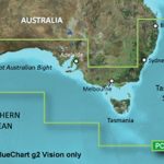
Garmin BlueChart g3 Vision – Southern Australia
Garmin BlueChart g2 Vision – Southern Australia [Garmin Part Number: 010-C0753-00] – RRP $399
Get a fresh perspective when you take to the water with BlueChart® g2 Vision®. With BlueChart g2 Vision data, you’ll get detailed marine cartography that provides convenient viewing of nautical content and other premium features. BlueChart g2 Vision allows you to see your vessel’s precise, on-chart position in relation to naviads, coastal features, anchorages, obstructions, waterways, restricted areas and more. You will also have access to detailed mapping capabilities that include Safety Shading, Fishing Charts, smooth data transition between zoom levels, harmonious transition across chart borders, and reduction of chart discontinuities. Premium features include 3-D perspective above and below the waterline, Auto Guidance, high-resolution imagery, and “real picture” aerial photos of ports, harbours, marinas, waterways, landmarks and other points of interest. It’s the most realistic mapping display Garmin has ever offered.
Detailed coverage of the Southern coast of Australia from Geraldton to Brisbane (VPC020R). Also includes detailed coverage of Perth, the Great Australian Bight, Adelaide, Melbourne, Tasmania, Sydney, and Norfolk Island. (if another region is required please contact us for availability).
THIS IS SUITABLE FOR CURRENT MODEL GARMIN GPSMAP 7407xsv, GPSMAP 7408xsv, GPSMAP 7410xsv, GPSMAP 7412xsv, echoMAP 75dv, echoMAP 75sv & echoMAP 95sv SOUNDER/GPS COMBO UNITS, PLEASE SEE RELATED PRODUCTS OR ASK FOR FURTHER INFORMATION.
WARRANTY:
We are an authorised Australian Garmin retailer, as such Full Australian Manufacturers Warranty is applicable for this item. Please note if a Garmin unit is purchased overseas or from a non-authorised Garmin retailer you may not receive warranty coverage in Australia.*Specifications from suppliers’ information. Actual depth capabilities depend on transducer installation, bottom type & water conditions. All sonars typically read deeper in freshwater than in saltwater. Images for display purposes only.
SKU: 010-C0753-00