Garmin GPSMAP 9019
Showing all 5 results
-
EOFY, Garmin, Garmin Chartplotters, Sanctuary Cove
Garmin GPSMAP 9010xsv – Premium chartplotter with worldwide basemap and sonar
-8% EOFY, Garmin, Garmin Chartplotters, Sanctuary Cove
Garmin GPSMAP 9010xsv – Premium chartplotter with worldwide basemap and sonar
Garmin GPSMAP 9010xsv is a premium chartplotter with a 10-inch HD touchscreen display, worldwide basemap, built-in sonar and Garmin BlueNet gigabit network connectivity.
SKU: 010-03175-02 -
EOFY, Garmin, Garmin Chartplotters, Sanctuary Cove
Garmin GPSMAP 9013xsv – Premium chartplotter with worldwide basemap and sonar
-10%EOFY, Garmin, Garmin Chartplotters, Sanctuary CoveGarmin GPSMAP 9013xsv – Premium chartplotter with worldwide basemap and sonar
Garmin GPSMAP 9010xsv is a premium chartplotter with a 10-inch HD touchscreen display, worldwide basemap, built-in sonar and Garmin BlueNet gigabit network connectivity.
SKU: 010-03176-02 -
EOFY, Garmin, Garmin Chartplotters, Sanctuary Cove
Garmin GPSMAP 9017xsv – Premium chartplotter with worldwide basemap and sonar
-8%EOFY, Garmin, Garmin Chartplotters, Sanctuary CoveGarmin GPSMAP 9017xsv – Premium chartplotter with worldwide basemap and sonar
Garmin GPSMAP 9010xsv is a premium chartplotter with a 10-inch HD touchscreen display, worldwide basemap, built-in sonar and Garmin BlueNet gigabit network connectivity.
SKU: 010-03177-02 -
EOFY, Garmin, Garmin Chartplotters, Sanctuary Cove
Garmin GPSMAP 9019 – 19inch Premium chartplotter with worldwide basemap
-6%EOFY, Garmin, Garmin Chartplotters, Sanctuary CoveGarmin GPSMAP 9019 – 19inch Premium chartplotter with worldwide basemap
Garmin GPSMAP 9022 – 19inch Premium Chartplotter with worldwide basemap
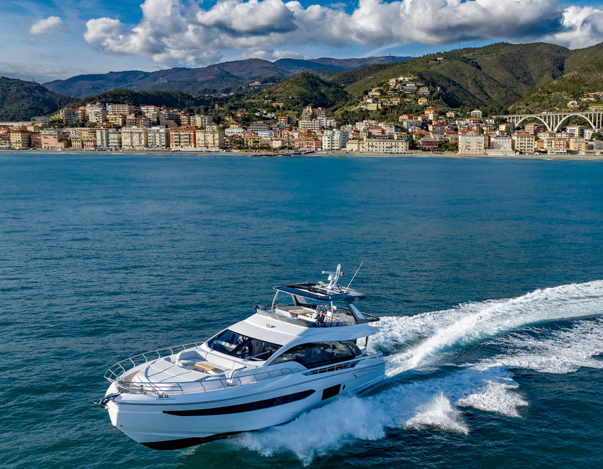
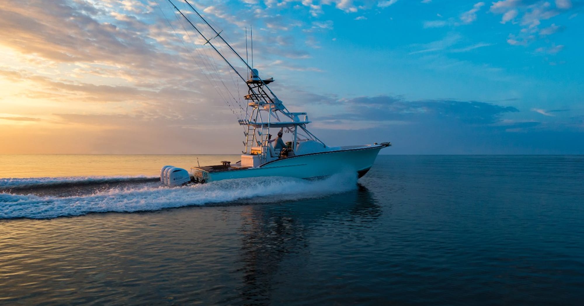
Plot your paradise
FROM YOUR PARADISESEE YOUR CHARTS, VIEW ENTERTAINMENT AND MORE IN 4K
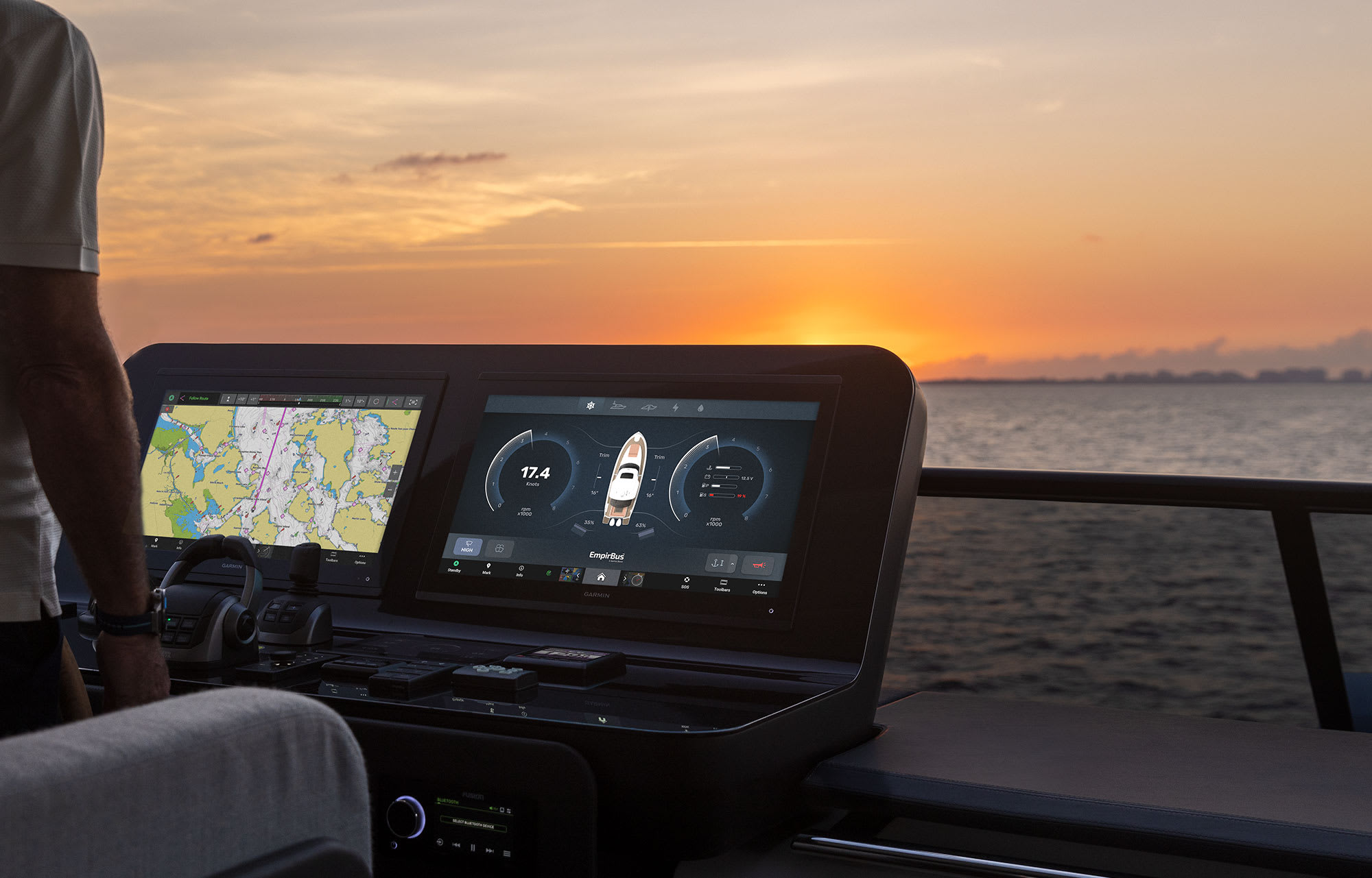
CLARITY, CONTROL AND LUXURY AT THE HELM

THE SPEED YOU NEEDUP TO SEVEN TIMES FASTER PROCESSING POWER AND GIGABIT SPEEDS ON THE GARMIN BLUENET™ NETWORK
CONNECTION IS KEYBUILD AN EXTENSIVE, TOP-OF-THE-LINE ECOSYSTEM
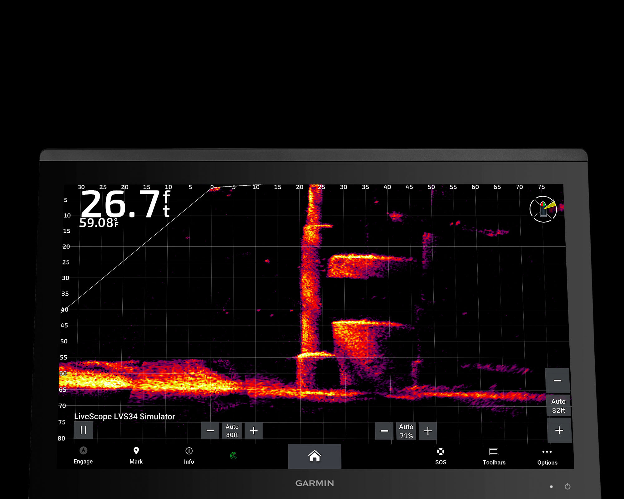
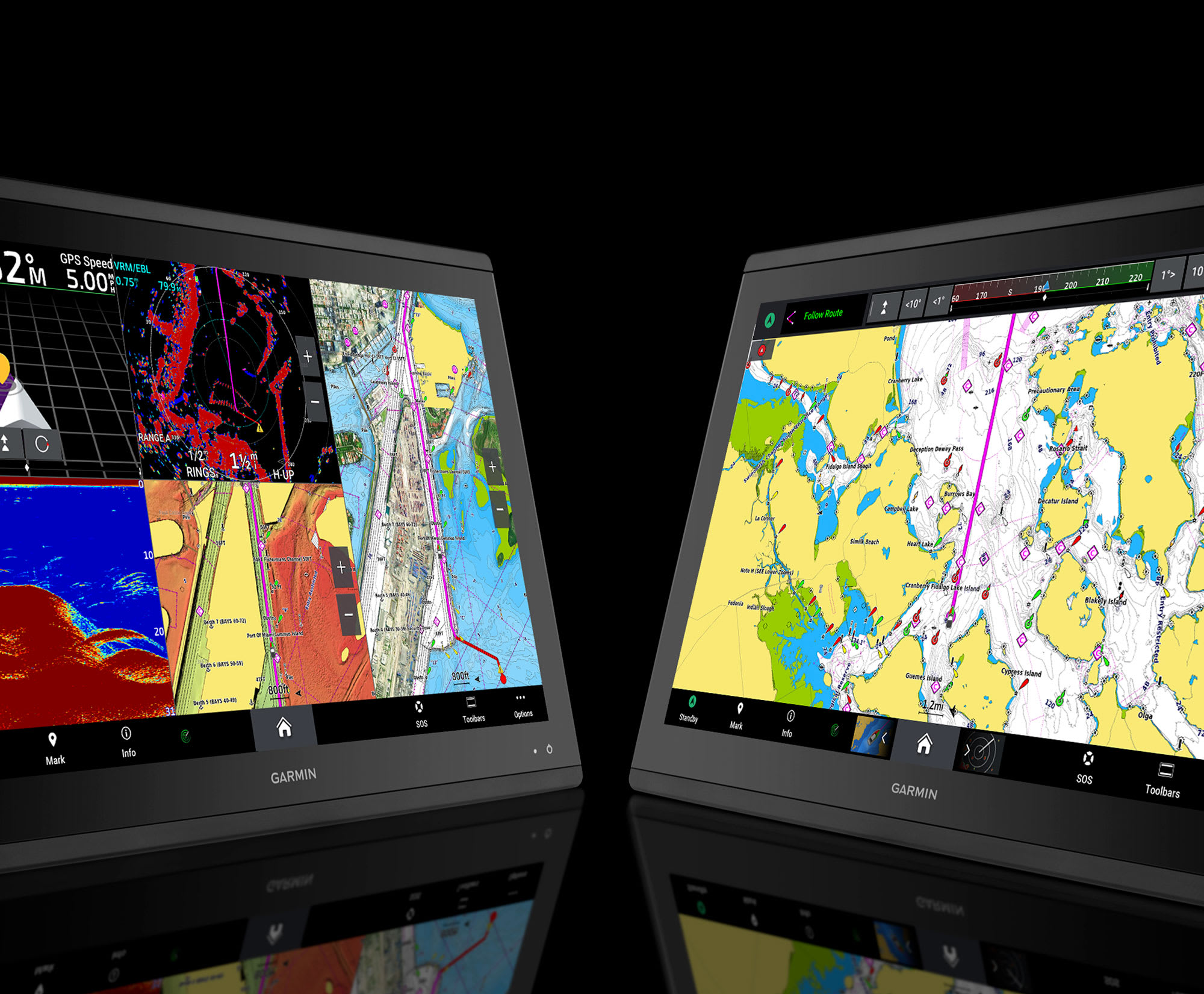
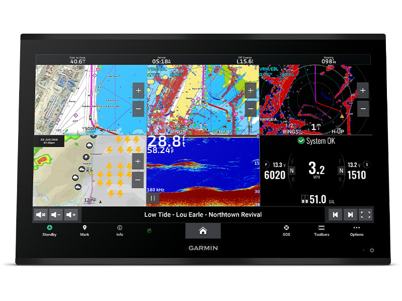
YOU’VE NEVER SEEN FISH THIS CLEARLY
WELCOME TO 4K PARADISE
It’s the industry’s first integrated 4K resolution touchscreen chartplotter. Enjoy edge-to-edge clarity and luxury on a glass helm with premium design and materials plus enhanced connectivity and speed.
 PREMIUM 4K IPS SUNLIGHT-READABLE TOUCHSCREEN DISPLAY
 UP TO 7 TIMES FASTER PROCESSING POWER THAN PREVIOUS GENERATIONS
 GIGABIT SPEEDS ON THE GARMIN BLUENET™ NETWORK
 VIDEO INTEGRATION CAPABILITIES WITH HDCP DISTRIBUTION
 SEE SONAR TARGETS LIKE NEVER BEFORE ON THE 4K DISPLAY1
 NETWORK WITH MULTIPLE CHARTPLOTTERS, CAMERAS AND SONARS
WHAT YOU’LL LOVE
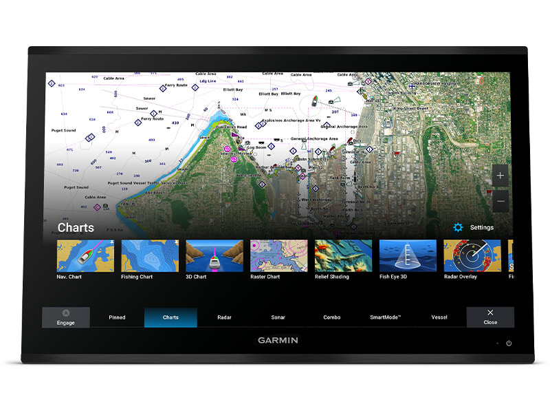
PREMIUM CHARTPLOTTER
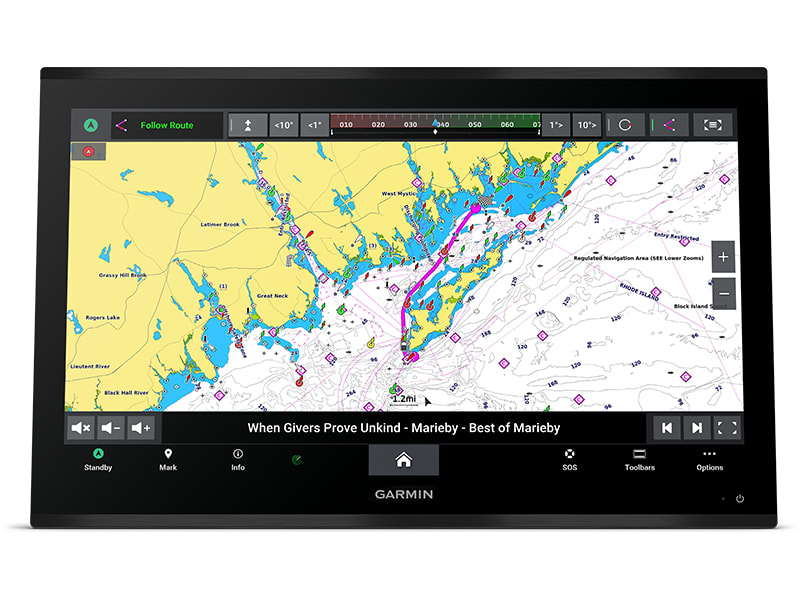
The 4K resolution IPS sunlight-readable touchscreen display is available in the industry’s largest integrated chartplotter size. Edge-to-edge design provides a seamless and luxurious modern look.
FASTER. MUCH FASTER.
Processing power is 7 times faster than previous generations for superior performance; draw charts quickly, and calculate Auto Guidance+™ routes2 with lightning speed with an optional Garmin Navionics+™ subscription.
GARMIN BLUENET NETWORK
Build extensive networks with multiple chartplotters, cameras, radars and sonars — and enjoy 10 times faster networking speeds with minimal lag.
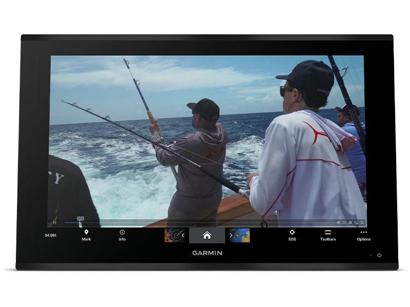
ENTERTAINMENT OPTIONS
Enjoy audio and video integrations that allow you to show and hear the same video throughout the screens and speakers on your network.
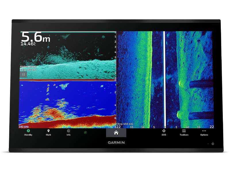
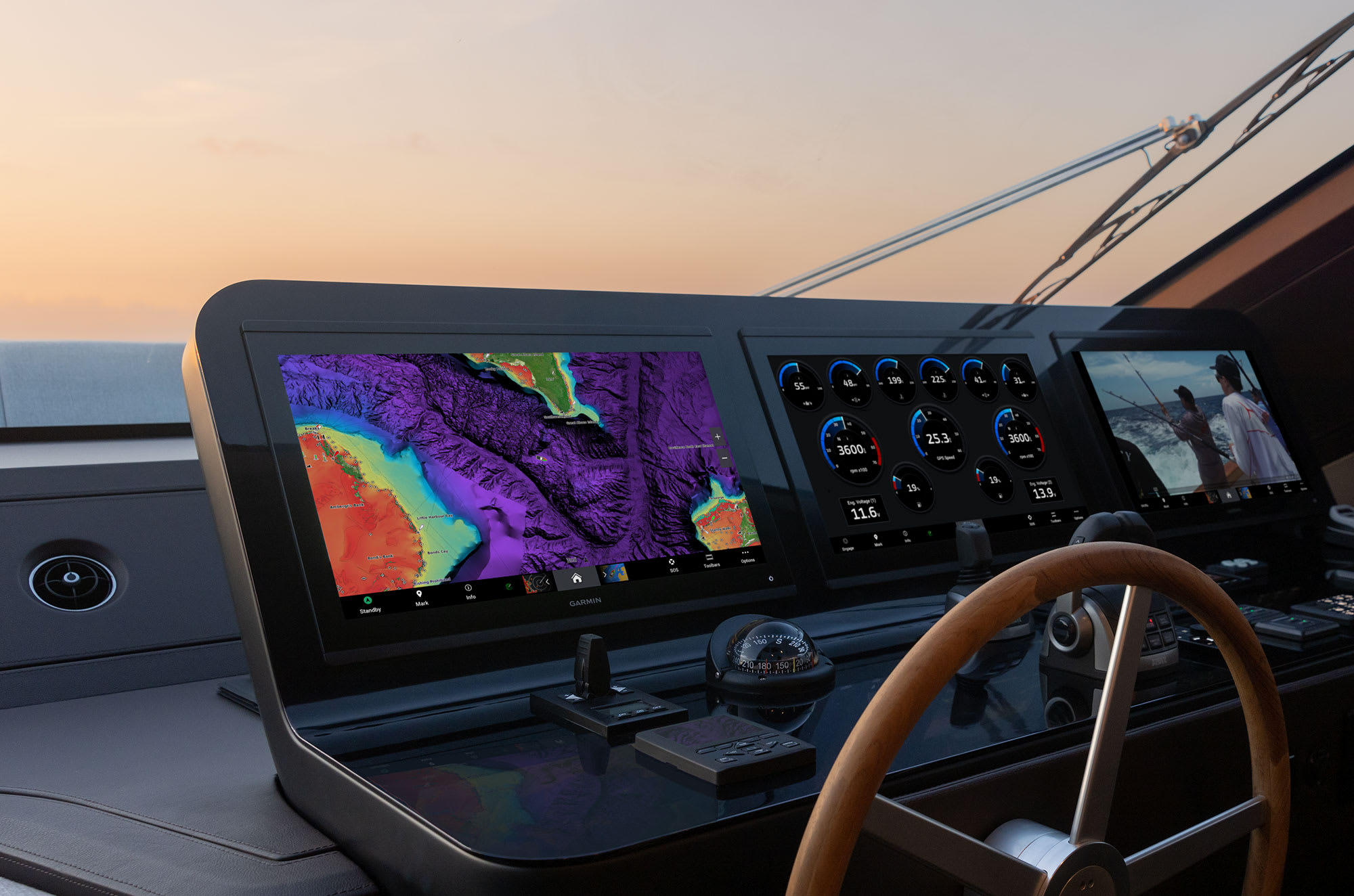
HIGH-DEFINITION SONAR
Fish in stunning high definition. Hook up to any of our sonar modules, and view sonar targets on the 4K display (transducers sold separately).
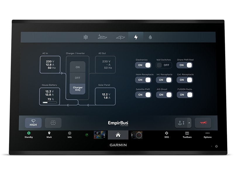
CONNECT YOUR ECOSYSTEM
Take command through digital system integrations to monitor, automate and control your vessel. The chartplotter uses the NMEA 2000® and NMEA 0183 networks to connect to your compatible accessories.
FOR CAPTAINS WHO DEMAND THE BEST CONNECT
 SOFTWARE UPDATES – Get wireless software updates via the ActiveCaptain® app with your compatible smartphone or tablet.
 ENGINE MONITORING – Keep tabs on engine performance with extensive engine integration.
 CUSTOM LOOK – Manufacturers can customise the homepage layout and splash screen for a brand tailored experience.
Navigate
 MAPPING – Navigate with optional Garmin Navionics+™ charts that include Auto Guidance+ technology, daily updates and more2 (subscription required).
 PREMIUM CHARTS – Get support for Garmin Navionics Vision+™ charts with premium relief shading and satellite imagery.
 KNOW WHERE YOU ARE – Get your precise location with the included GPS 24xd position receiver and antenna.
 AUTOPILOT – Control the autopilot with any compatible chartplotter on the network with autopilot integration.
INTEGRATE
CONNECT CAMERAS – Get extensive camera support and control to see footage directly on the chartplotter. SURROUND VIEW SYSTEM – Get a bird’s-eye view with support for our Surround View Camera System (accessory purchase required).
 CONTROL WITH YOUR WATCH – Connect to your chartplotter with your compatible Garmin smartwatch.
 WIRELESS CONNECTIVITY – Connect compatible devices with integrated BLUETOOTH® and ANT® technologies.
 FISH MAPPING – Get comprehensive fishing data with the Fish Mapping™ feature from SiriusXM® Radio (accessory purchase and subscription required).
 VERBAL COMMANDS – Use spoken commands to control the chartplotter through your compatible headset.
 WEATHER-RESISTANT – The GPSMAP 9000 chartplotter is built for harsh marine conditions with an IPX7 water-resistance rating.1Sonar black box and transducers sold separately2Auto Guidance+ is for planning purposes only and does not replace safe navigation operationsThe Bluetooth word mark and logos are registered trademarks owned by Bluetooth SIG, Inc. and any use of such marks by Garmin is under licence. Sirius, XM and all related marks and logos are trademarks of Sirius XM Radio Inc.Engineering enhancements are ongoing and may not be reflected in the pictures, videos and specifications.
In the box
- GPSMAP® 9022 Chartplotter
- Trim snap cover
- Protective cover
- Flush mount hardware
- Power cable
- GPS 24xd NMEA 2000® (with pole mount, flush mount and under deck mount adapters)
- NMEA 2000 backbone/drop cable (2 metres)
- NMEA 2000 power cable
- NMEA 2000 T-connector and terminator kit
- Documentation
Installation Instruction
Owner’s Manual
SKU: 010-02673-00 -
Garmin, Garmin Chartplotters
Garmin GPSMAP 9022 – 22inch Premium chartplotter with worldwide basemap
Garmin GPSMAP 9022 – 22″ Premium Chartplotter with worldwide basemap
Plot your paradise
FROM YOUR PARADISESEE YOUR CHARTS, VIEW ENTERTAINMENT AND MORE IN 4K
CLARITY, CONTROL AND LUXURY AT THE HELM
THE SPEED YOU NEEDUP TO SEVEN TIMES FASTER PROCESSING POWER AND GIGABIT SPEEDS ON THE GARMIN BLUENET™ NETWORK
CONNECTION IS KEYBUILD AN EXTENSIVE, TOP-OF-THE-LINE ECOSYSTEM
YOU’VE NEVER SEEN FISH THIS CLEARLY
WELCOME TO 4K PARADISE
It’s the industry’s first integrated 4K resolution touchscreen chartplotter. Enjoy edge-to-edge clarity and luxury on a glass helm with premium design and materials plus enhanced connectivity and speed.
PREMIUM 4K IPS SUNLIGHT-READABLE TOUCHSCREEN DISPLAY UP TO 7 TIMES FASTER PROCESSING POWER THAN PREVIOUS GENERATIONS GIGABIT SPEEDS ON THE GARMIN BLUENET™ NETWORK VIDEO INTEGRATION CAPABILITIES WITH HDCP DISTRIBUTION SEE SONAR TARGETS LIKE NEVER BEFORE ON THE 4K DISPLAY1 NETWORK WITH MULTIPLE CHARTPLOTTERS, CAMERAS AND SONARSWHAT YOU’LL LOVE
PREMIUM CHARTPLOTTER
The 4K resolution IPS sunlight-readable touchscreen display is available in the industry’s largest integrated chartplotter size. Edge-to-edge design provides a seamless and luxurious modern look.
FASTER. MUCH FASTER.
Processing power is 7 times faster than previous generations for superior performance; draw charts quickly, and calculate Auto Guidance+™ routes2 with lightning speed with an optional Garmin Navionics+™ subscription.
GARMIN BLUENET NETWORK
Build extensive networks with multiple chartplotters, cameras, radars and sonars — and enjoy 10 times faster networking speeds with minimal lag.
ENTERTAINMENT OPTIONS
Enjoy audio and video integrations that allow you to show and hear the same video throughout the screens and speakers on your network.
HIGH-DEFINITION SONAR
Fish in stunning high definition. Hook up to any of our sonar modules, and view sonar targets on the 4K display (transducers sold separately).
CONNECT YOUR ECOSYSTEM
Take command through digital system integrations to monitor, automate and control your vessel. The chartplotter uses the NMEA 2000® and NMEA 0183 networks to connect to your compatible accessories.
FOR CAPTAINS WHO DEMAND THE BEST CONNECT
SOFTWARE UPDATES – Get wireless software updates via the ActiveCaptain® app with your compatible smartphone or tablet. ENGINE MONITORING – Keep tabs on engine performance with extensive engine integration. CUSTOM LOOK – Manufacturers can customise the homepage layout and splash screen for a brand tailored experience.Navigate
MAPPING – Navigate with optional Garmin Navionics+™ charts that include Auto Guidance+ technology, daily updates and more2 (subscription required). PREMIUM CHARTS – Get support for Garmin Navionics Vision+™ charts with premium relief shading and satellite imagery. KNOW WHERE YOU ARE – Get your precise location with the included GPS 24xd position receiver and antenna. AUTOPILOT – Control the autopilot with any compatible chartplotter on the network with autopilot integration.INTEGRATE
CONNECT CAMERAS – Get extensive camera support and control to see footage directly on the chartplotter. SURROUND VIEW SYSTEM – Get a bird’s-eye view with support for our Surround View Camera System (accessory purchase required). CONTROL WITH YOUR WATCH – Connect to your chartplotter with your compatible Garmin smartwatch. WIRELESS CONNECTIVITY – Connect compatible devices with integrated BLUETOOTH® and ANT® technologies. FISH MAPPING – Get comprehensive fishing data with the Fish Mapping™ feature from SiriusXM® Radio (accessory purchase and subscription required). VERBAL COMMANDS – Use spoken commands to control the chartplotter through your compatible headset. WEATHER-RESISTANT – The GPSMAP 9000 chartplotter is built for harsh marine conditions with an IPX7 water-resistance rating.1Sonar black box and transducers sold separately2Auto Guidance+ is for planning purposes only and does not replace safe navigation operationsThe Bluetooth word mark and logos are registered trademarks owned by Bluetooth SIG, Inc. and any use of such marks by Garmin is under licence. Sirius, XM and all related marks and logos are trademarks of Sirius XM Radio Inc.Engineering enhancements are ongoing and may not be reflected in the pictures, videos and specifications.In the box
- GPSMAP® 9022 Chartplotter
- Trim snap cover
- Protective cover
- Flush mount hardware
- Power cable
- GPS 24xd NMEA 2000® (with pole mount, flush mount and under deck mount adapters)
- NMEA 2000 backbone/drop cable (2 metres)
- NMEA 2000 power cable
- NMEA 2000 T-connector and terminator kit
- Documentation
Installation Instruction
Owner’s Manual
SKU: 010-02674-00
