Garmin Charts
Showing all 12 results
-
Charts & Maps, EOFY, Garmin, Sanctuary Cove
Garmin Navionics Platinum+™ Australia, Northeast – Marine Charts
-10% Charts & Maps, EOFY, Garmin, Sanctuary Cove
Garmin Navionics Platinum+™ Australia, Northeast – Marine Charts
Garmin Navionics Platinum+™ Australia, Northeast – Marine Charts
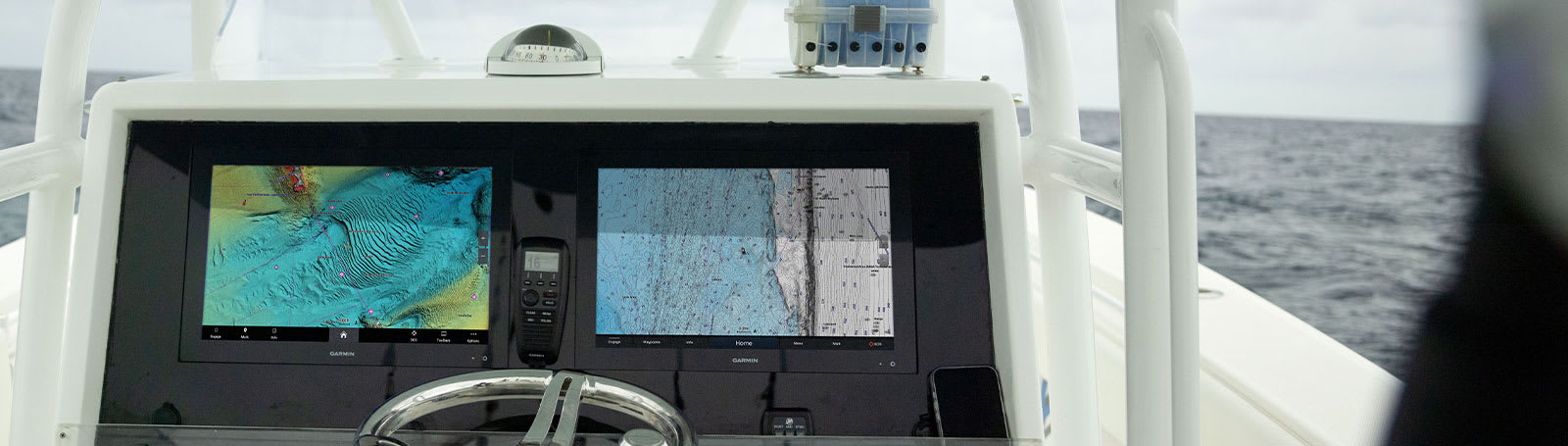
INTEGRATED MAPPING FOR A WIDE RANGE OF CHARTPLOTTERS
A comprehensive, all-in-one solution, Navionics+ charts and maps combine clear, reliable coastal/inland content with advanced guidance features and compatibility with a wide range of chartplotter brands.
 Navigate with our best offshore and inland lake coverage for your compatible chartplotter1.
 See it your way. Customise your view with various chart layers and overlay combinations.
 With your included 1-year subscription, access daily updates via the Navionics® chart installer software.
 Advanced route guidance technology2 lets you navigate with suggested dock-to-dock routings.
 Selectable map options let you highlight shallow areas, adjust contour density or select a fishing range.
 Save money — while continuing to access daily updates plus new content downloads — by renewing your subscription3.
Seamlessly navigate on coastal or inland waters.
ALL-IN-ONE MAP SOLUTION
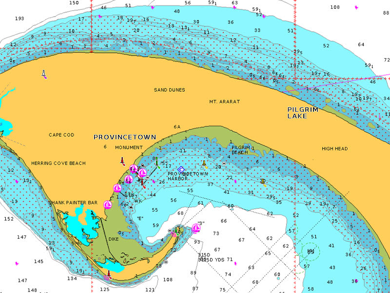
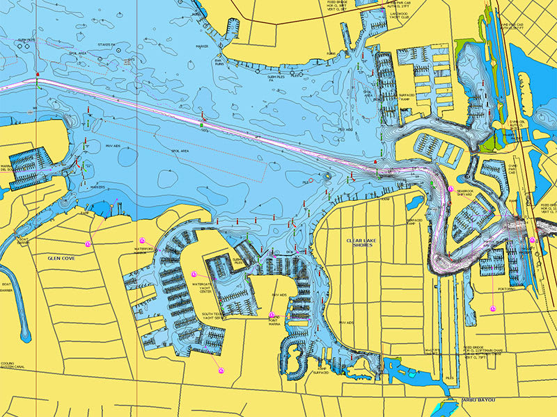
Access detail-rich mapping of coastal features, lakes, rivers and more on a wide range of compatible chartplotters. Integrated coastal and inland lake content offers coverage for boaters worldwide.

DAILY CHART UPDATES
Charts are constantly being enhanced with new and amended content — thousands of updates are made every day. The included 1-year subscription gives you access to daily chart updates via the Navionics chart installer software.
DOCK-TO-DOCK ROUTE GUIDANCE
Advanced route guidance technology2 uses your boat settings, along with chart data and frequently traveled routes, to calculate a suggested path to follow from dock to dock.
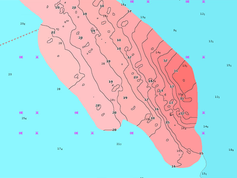
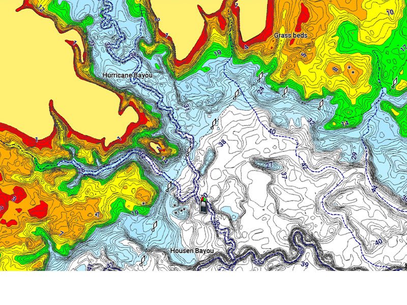
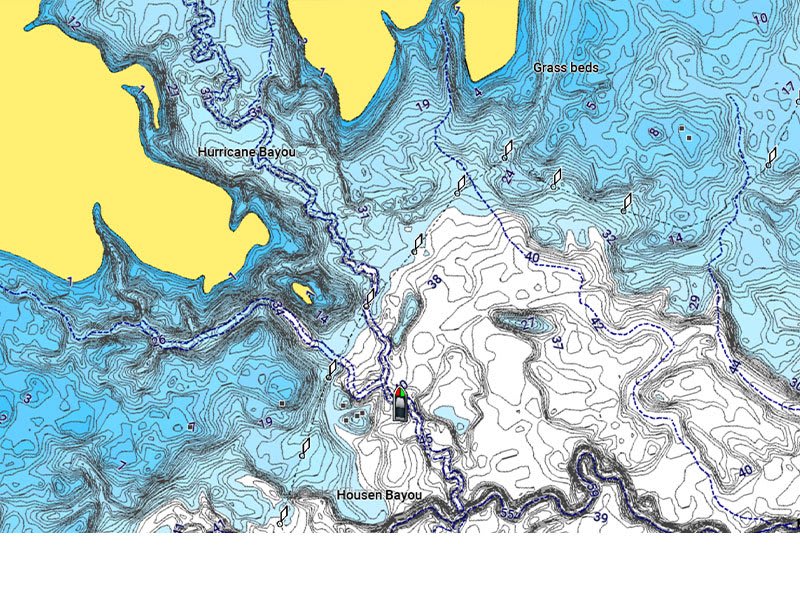
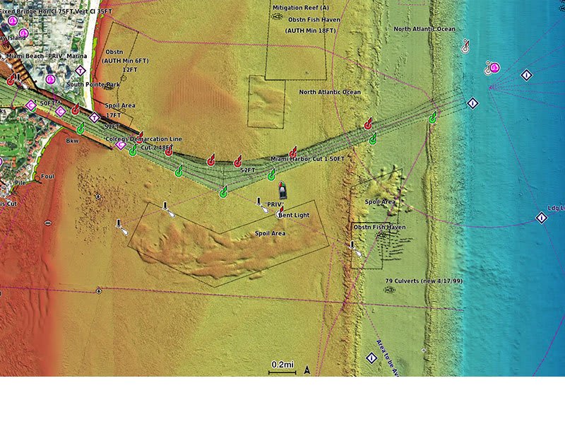
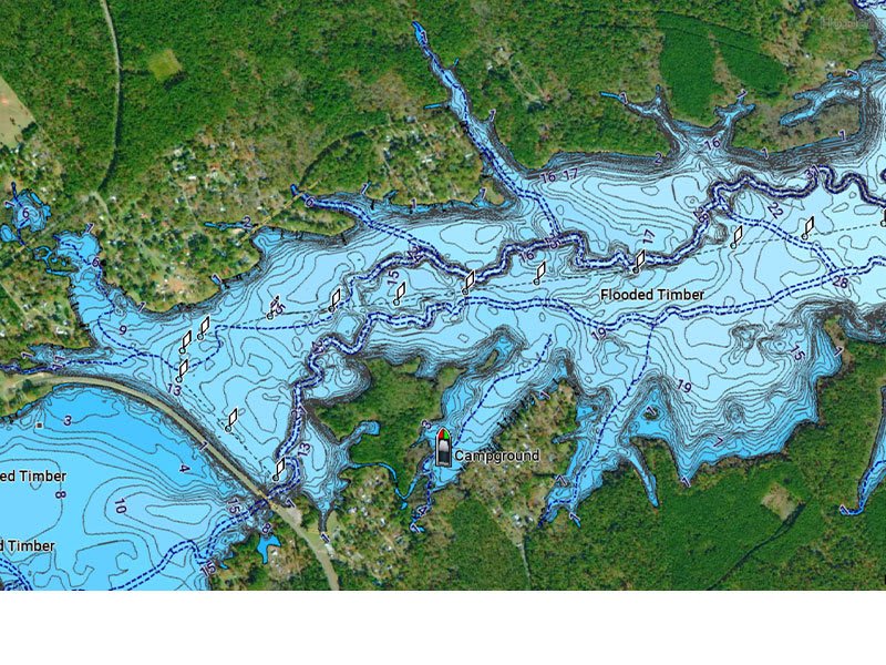
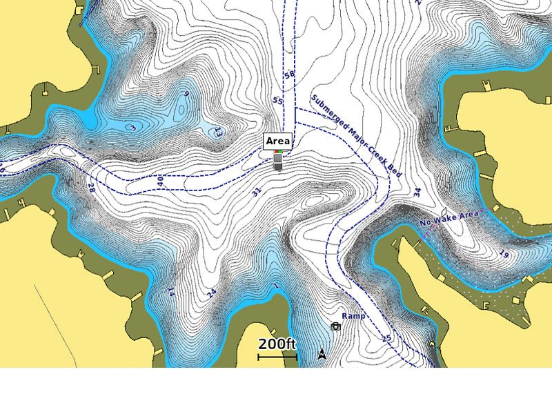
UP TO 0.5 M CONTOURS
For improved fishing and navigation, up to 0,5 m contours provide a clear depiction of bottom structure for fishing charts as well as enhanced detail in swamps, canals, harbours, marinas and more.
ADVANCED MAP OPTIONS
Change the way you view Navionics charts to focus on the details that matter most to you. Highlight shallow areas, adjust contour density, or select a fishing range.

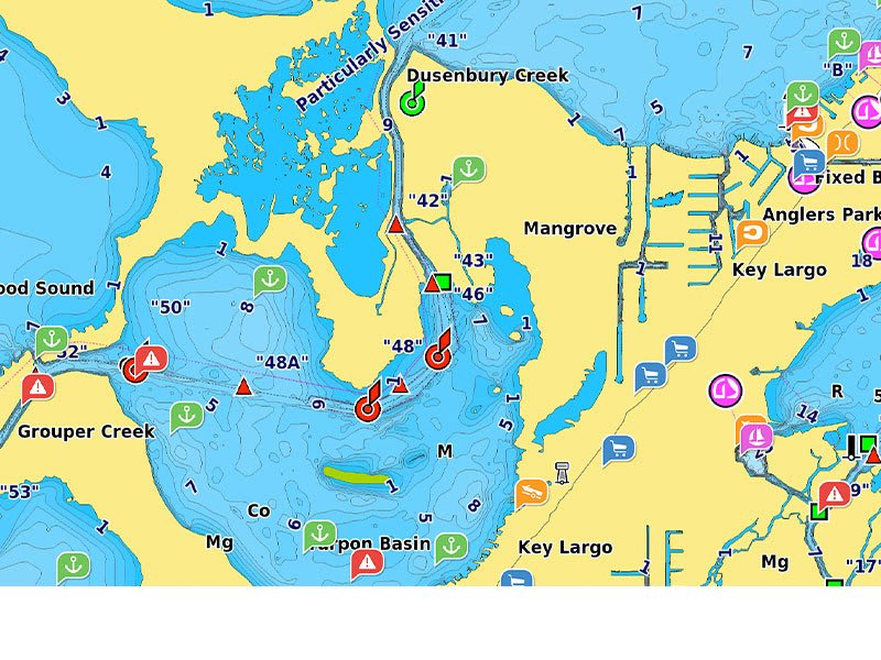
COMMUNITY EDITS
Download community edits for useful local knowledge added by users of the Navionics Boating app, and view the data on your compatible chartplotter.
PLOTTER SYNC
Transfer routes and markers, update charts and more between your plotter card and mobile app — wirelessly. You can even activate or renew your cartography subscription and upload sonar logs4.
SONARCHART™ LIVE MAPPING
Create your own maps on the fly. Watch new 1’ HD bathymetry maps develop in real time as your boat moves through the water.
Add premium features with Navionics Platinum+™ mapping solutions.
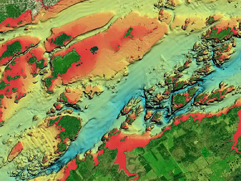
RELIEF SHADING
This downloadable shading feature5 combines color and shadow to give you an easy-to-interpret, clearer view of bottom structure than contour lines alone.
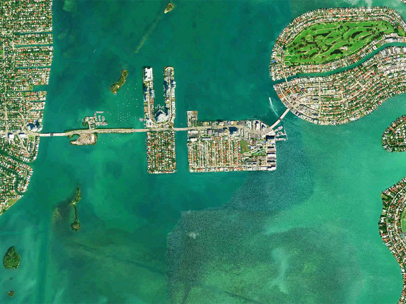
HIGH-RESOLUTION SATELLITE IMAGERY
Downloadable high-resolution satellite imagery5 provides a realistic view of your surroundings — ideal for entering unfamiliar harbors or ports.
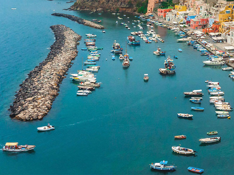
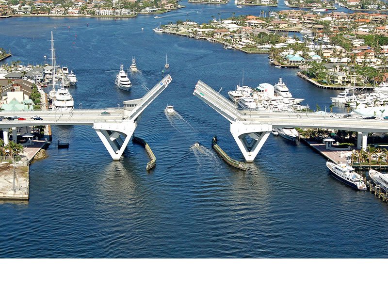
AERIAL PHOTOGRAPHY
Crystal-clear aerial and surface photos of ports, marinas, bridges, docks, boat ramps, dams and navigational landmarks provide a better sense of your surroundings above the waterline.
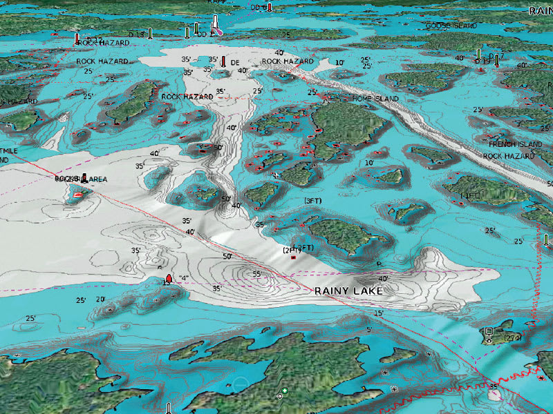
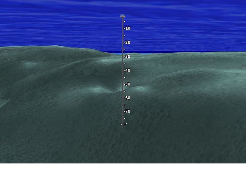
3D VIEW
Unique 3D views provide additional perspective, both above and below the water’s surface, to highlight key features and aid in situational awareness.
SKU: 010-C1360-40 -
Charts & Maps, EOFY, Garmin, Sanctuary Cove
Garmin Navionics Vision+™ Australia, East & Central to New Zealand – Marine Charts
-10% Charts & Maps, EOFY, Garmin, Sanctuary Cove
Garmin Navionics Vision+™ Australia, East & Central to New Zealand – Marine Charts
Garmin Navionics Vision+™ Australia, East & Central to New Zealand – Marine Charts
IT’S A WHOLE NEW LOOK ON YOUR CHARTPLOTTER
Featuring vibrant colors, a streamlined interface and combined coastal/inland content with a popular Navionics® style color palette, Garmin Navionics+ cartography makes it easy to plot your course with the world’s No. 1 name in marine mapping1.
 Navigate with our best offshore and inland lake coverage for your Garmin chartplotter.
 See it your way. Customize your view with various chart layers and overlay combinations.
 With your included one-year subscription, access daily updates via the ActiveCaptain® smart-device app.
 Auto Guidance+™ technology2 lets you navigate with suggested dock-to-dock routings.
 Select up to 10 color-shaded target depth ranges to scope out the best fishing spots. Save money by renewing your subscription — and continue accessing daily updates plus new content downloads.
Plot your paradise on coastal or inland waters.
ALL-IN-ONE MAP SOLUTION FOR GARMIN CHARTPLOTTERS
Access detail-rich mapping of coastal features, lakes, rivers and more. Integrated Garmin and Navionics® content offers coverage for boaters worldwide.
DAILY CHART UPDATES
Charts are constantly being enhanced with new and amended content: Thousands of updates are made every day. The one-year included subscription gives you access to daily chart updates via the ActiveCaptain app.
AUTO GUIDANCE+ TECHNOLOGY
Combining the best of Garmin and Navionics automatic routing features, built-in Auto Guidance+ technology2 gives you a suggested dock-to-dock path to follow through channels, inlets, marina entrances and more.
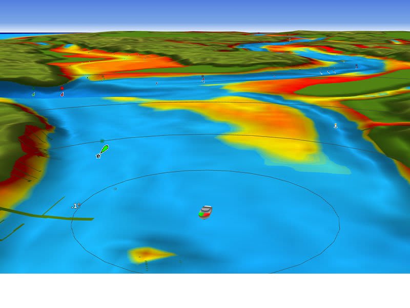
DEPTH RANGE SHADING
High-resolution depth range shading lets you select up to 10 color-shaded options and view your designated target depths at a glance.
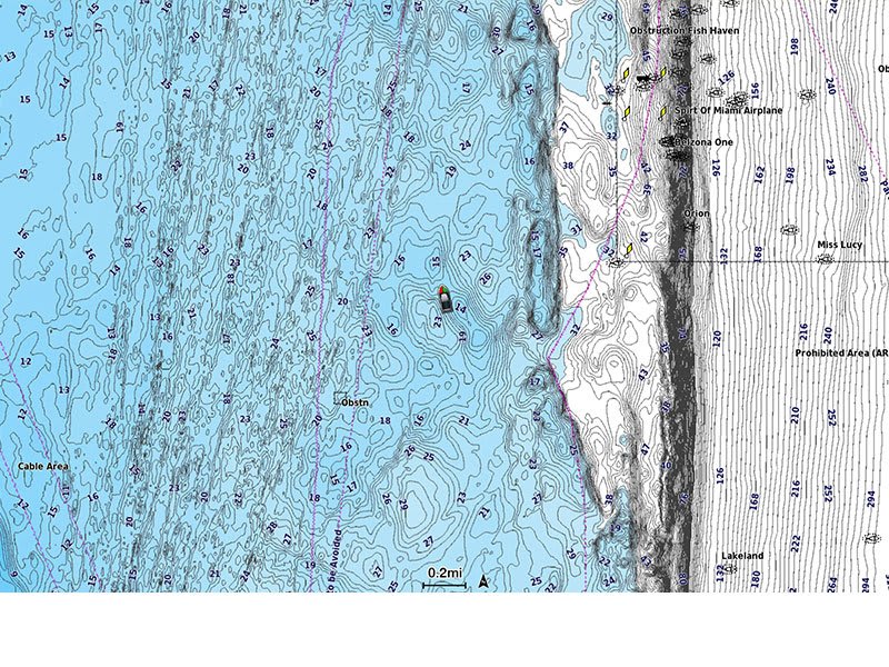
UP TO 1’ CONTOURS
For improved fishing and navigation, up to 1′ contours provide a clear depiction of bottom structure for improved fishing charts and enhanced detail in swamps, canals, harbors, marinas and more.
SHALLOW WATER SHADING
To give a clear picture of shallow waters to avoid, this feature allows for shading at a user-defined depth.
ACTIVECAPTAIN COMMUNITY
Community-sourced content provides useful points of interest, such as marinas, anchorages, hazards, businesses and more. Get recommendations from boaters with firsthand experience of the local environment.
Add premium features with Garmin Navionics Vision+ mapping solutions.
HIGH-RESOLUTION RELIEF SHADING
This detailed shading feature3 combines color and shadow to give you an easy-to-interpret, clearer view of bottom structure than contour lines alone.
HIGH-RESOLUTION SATELLITE IMAGERY
Downloadable high-resolution satellite imagery3 provides superior situational awareness.
AERIAL PHOTOS
Crystal-clear aerial and surface photos of ports, marinas, bridges, docks, boat ramps, dams and navigational landmarks provide a better sense of your surroundings above the waterline.
3D FISHEYE VIEW
This underwater perspective shows 3D representation of bottom and contours as seen from below the waterline. Interface with sonar data for a customized view.
3D MARINEREYE VIEW
This view provides a 3D representation of the surrounding area both above and below the waterline.
DYNAMIC LAKE LEVEL
Adjust your maps to the lake’s current water levels to see if spots are accessible or too shallow to explore.
SKU: 010-C1482-00 -
Charts & Maps, EOFY, Garmin, Sanctuary Cove
Garmin Navionics Vision+™ Australia, Northeast – Inland and Coastal Marine Charts
-10% Charts & Maps, EOFY, Garmin, Sanctuary Cove
Garmin Navionics Vision+™ Australia, Northeast – Inland and Coastal Marine Charts
Garmin Navionics Vision+™ Australia, Northeast – Inland and Coastal Marine Charts
IT’S A WHOLE NEW LOOK ON YOUR CHARTPLOTTER
Featuring vibrant colors, a streamlined interface and combined coastal/inland content with a popular Navionics® style color palette, Garmin Navionics+ cartography makes it easy to plot your course with the world’s No. 1 name in marine mapping1.
Navigate with our best offshore and inland lake coverage for your Garmin chartplotter. See it your way. Customize your view with various chart layers and overlay combinations. With your included one-year subscription, access daily updates via the ActiveCaptain® smart-device app. Auto Guidance+™ technology2 lets you navigate with suggested dock-to-dock routings. Select up to 10 color-shaded target depth ranges to scope out the best fishing spots. Save money by renewing your subscription — and continue accessing daily updates plus new content downloads.Plot your paradise on coastal or inland waters.
ALL-IN-ONE MAP SOLUTION FOR GARMIN CHARTPLOTTERS
Access detail-rich mapping of coastal features, lakes, rivers and more. Integrated Garmin and Navionics® content offers coverage for boaters worldwide.
DAILY CHART UPDATES
Charts are constantly being enhanced with new and amended content: Thousands of updates are made every day. The one-year included subscription gives you access to daily chart updates via the ActiveCaptain app.
AUTO GUIDANCE+ TECHNOLOGY
Combining the best of Garmin and Navionics automatic routing features, built-in Auto Guidance+ technology2 gives you a suggested dock-to-dock path to follow through channels, inlets, marina entrances and more.
DEPTH RANGE SHADING
High-resolution depth range shading lets you select up to 10 color-shaded options and view your designated target depths at a glance.
UP TO 1’ CONTOURS
For improved fishing and navigation, up to 1′ contours provide a clear depiction of bottom structure for improved fishing charts and enhanced detail in swamps, canals, harbors, marinas and more.
SHALLOW WATER SHADING
To give a clear picture of shallow waters to avoid, this feature allows for shading at a user-defined depth.
ACTIVECAPTAIN COMMUNITY
Community-sourced content provides useful points of interest, such as marinas, anchorages, hazards, businesses and more. Get recommendations from boaters with firsthand experience of the local environment.
Add premium features with Garmin Navionics Vision+ mapping solutions.
HIGH-RESOLUTION RELIEF SHADING
This detailed shading feature3 combines color and shadow to give you an easy-to-interpret, clearer view of bottom structure than contour lines alone.
HIGH-RESOLUTION SATELLITE IMAGERY
Downloadable high-resolution satellite imagery3 provides superior situational awareness.
AERIAL PHOTOS
Crystal-clear aerial and surface photos of ports, marinas, bridges, docks, boat ramps, dams and navigational landmarks provide a better sense of your surroundings above the waterline.
3D FISHEYE VIEW
This underwater perspective shows 3D representation of bottom and contours as seen from below the waterline. Interface with sonar data for a customized view.
3D MARINEREYE VIEW
This view provides a 3D representation of the surrounding area both above and below the waterline.
DYNAMIC LAKE LEVEL
Adjust your maps to the lake’s current water levels to see if spots are accessible or too shallow to explore.
SKU: 010-C1281-00 -
Charts & Maps, EOFY, Garmin, Sanctuary Cove
Garmin Navionics Vision+™ Australia, Southeast – Inland and Coastal Marine Charts
-10% Charts & Maps, EOFY, Garmin, Sanctuary Cove
Garmin Navionics Vision+™ Australia, Southeast – Inland and Coastal Marine Charts
Garmin Navionics Vision+™ Australia, Southeast – Inland and Coastal Marine Charts
IT’S A WHOLE NEW LOOK ON YOUR CHARTPLOTTER
Featuring vibrant colors, a streamlined interface and combined coastal/inland content with a popular Navionics® style color palette, Garmin Navionics+ cartography makes it easy to plot your course with the world’s No. 1 name in marine mapping1.
Navigate with our best offshore and inland lake coverage for your Garmin chartplotter. See it your way. Customize your view with various chart layers and overlay combinations. With your included one-year subscription, access daily updates via the ActiveCaptain® smart-device app. Auto Guidance+™ technology2 lets you navigate with suggested dock-to-dock routings. Select up to 10 color-shaded target depth ranges to scope out the best fishing spots. Save money by renewing your subscription — and continue accessing daily updates plus new content downloads.Plot your paradise on coastal or inland waters.
ALL-IN-ONE MAP SOLUTION FOR GARMIN CHARTPLOTTERS
Access detail-rich mapping of coastal features, lakes, rivers and more. Integrated Garmin and Navionics® content offers coverage for boaters worldwide.
DAILY CHART UPDATES
Charts are constantly being enhanced with new and amended content: Thousands of updates are made every day. The one-year included subscription gives you access to daily chart updates via the ActiveCaptain app.
AUTO GUIDANCE+ TECHNOLOGY
Combining the best of Garmin and Navionics automatic routing features, built-in Auto Guidance+ technology2 gives you a suggested dock-to-dock path to follow through channels, inlets, marina entrances and more.
DEPTH RANGE SHADING
High-resolution depth range shading lets you select up to 10 color-shaded options and view your designated target depths at a glance.
UP TO 1’ CONTOURS
For improved fishing and navigation, up to 1′ contours provide a clear depiction of bottom structure for improved fishing charts and enhanced detail in swamps, canals, harbors, marinas and more.
SHALLOW WATER SHADING
To give a clear picture of shallow waters to avoid, this feature allows for shading at a user-defined depth.
ACTIVECAPTAIN COMMUNITY
Community-sourced content provides useful points of interest, such as marinas, anchorages, hazards, businesses and more. Get recommendations from boaters with firsthand experience of the local environment.
Add premium features with Garmin Navionics Vision+ mapping solutions.
HIGH-RESOLUTION RELIEF SHADING
This detailed shading feature3 combines color and shadow to give you an easy-to-interpret, clearer view of bottom structure than contour lines alone.
HIGH-RESOLUTION SATELLITE IMAGERY
Downloadable high-resolution satellite imagery3 provides superior situational awareness.
AERIAL PHOTOS
Crystal-clear aerial and surface photos of ports, marinas, bridges, docks, boat ramps, dams and navigational landmarks provide a better sense of your surroundings above the waterline.
3D FISHEYE VIEW
This underwater perspective shows 3D representation of bottom and contours as seen from below the waterline. Interface with sonar data for a customized view.
3D MARINEREYE VIEW
This view provides a 3D representation of the surrounding area both above and below the waterline.
DYNAMIC LAKE LEVEL
Adjust your maps to the lake’s current water levels to see if spots are accessible or too shallow to explore.
SKU: 010-C1282-00 -
Charts & Maps, EOFY, Garmin, Sanctuary Cove
Garmin Navionics Vision+™ Australia, West – Inland and Coastal Marine Charts
-10% Charts & Maps, EOFY, Garmin, Sanctuary Cove
Garmin Navionics Vision+™ Australia, West – Inland and Coastal Marine Charts
Garmin Navionics Vision+™ Australia, West – Inland and Coastal Marine Charts
IT’S A WHOLE NEW LOOK ON YOUR CHARTPLOTTER
Featuring vibrant colors, a streamlined interface and combined coastal/inland content with a popular Navionics® style color palette, Garmin Navionics+ cartography makes it easy to plot your course with the world’s No. 1 name in marine mapping1.
Navigate with our best offshore and inland lake coverage for your Garmin chartplotter. See it your way. Customize your view with various chart layers and overlay combinations. With your included one-year subscription, access daily updates via the ActiveCaptain® smart-device app. Auto Guidance+™ technology2 lets you navigate with suggested dock-to-dock routings. Select up to 10 color-shaded target depth ranges to scope out the best fishing spots. Save money by renewing your subscription — and continue accessing daily updates plus new content downloads.Plot your paradise on coastal or inland waters.
ALL-IN-ONE MAP SOLUTION FOR GARMIN CHARTPLOTTERS
Access detail-rich mapping of coastal features, lakes, rivers and more. Integrated Garmin and Navionics® content offers coverage for boaters worldwide.
DAILY CHART UPDATES
Charts are constantly being enhanced with new and amended content: Thousands of updates are made every day. The one-year included subscription gives you access to daily chart updates via the ActiveCaptain app.
AUTO GUIDANCE+ TECHNOLOGY
Combining the best of Garmin and Navionics automatic routing features, built-in Auto Guidance+ technology2 gives you a suggested dock-to-dock path to follow through channels, inlets, marina entrances and more.
DEPTH RANGE SHADING
High-resolution depth range shading lets you select up to 10 color-shaded options and view your designated target depths at a glance.
UP TO 1’ CONTOURS
For improved fishing and navigation, up to 1′ contours provide a clear depiction of bottom structure for improved fishing charts and enhanced detail in swamps, canals, harbors, marinas and more.
SHALLOW WATER SHADING
To give a clear picture of shallow waters to avoid, this feature allows for shading at a user-defined depth.
ACTIVECAPTAIN COMMUNITY
Community-sourced content provides useful points of interest, such as marinas, anchorages, hazards, businesses and more. Get recommendations from boaters with firsthand experience of the local environment.
Add premium features with Garmin Navionics Vision+ mapping solutions.
HIGH-RESOLUTION RELIEF SHADING
This detailed shading feature3 combines color and shadow to give you an easy-to-interpret, clearer view of bottom structure than contour lines alone.
HIGH-RESOLUTION SATELLITE IMAGERY
Downloadable high-resolution satellite imagery3 provides superior situational awareness.
AERIAL PHOTOS
Crystal-clear aerial and surface photos of ports, marinas, bridges, docks, boat ramps, dams and navigational landmarks provide a better sense of your surroundings above the waterline.
3D FISHEYE VIEW
This underwater perspective shows 3D representation of bottom and contours as seen from below the waterline. Interface with sonar data for a customized view.
3D MARINEREYE VIEW
This view provides a 3D representation of the surrounding area both above and below the waterline.
DYNAMIC LAKE LEVEL
Adjust your maps to the lake’s current water levels to see if spots are accessible or too shallow to explore.
SKU: 010-C1280-00 -
Charts & Maps, EOFY, Garmin, Sanctuary Cove
Garmin Navionics Vision+™ Australia, West & Central – Marine Charts
-10% Charts & Maps, EOFY, Garmin, Sanctuary Cove
Garmin Navionics Vision+™ Australia, West & Central – Marine Charts
Garmin Navionics Vision+™ Australia, West & Central – Marine Charts
IT’S A WHOLE NEW LOOK ON YOUR CHARTPLOTTER
Featuring vibrant colors, a streamlined interface and combined coastal/inland content with a popular Navionics® style color palette, Garmin Navionics+ cartography makes it easy to plot your course with the world’s No. 1 name in marine mapping1.
Navigate with our best offshore and inland lake coverage for your Garmin chartplotter. See it your way. Customize your view with various chart layers and overlay combinations. With your included one-year subscription, access daily updates via the ActiveCaptain® smart-device app. Auto Guidance+™ technology2 lets you navigate with suggested dock-to-dock routings. Select up to 10 color-shaded target depth ranges to scope out the best fishing spots. Save money by renewing your subscription — and continue accessing daily updates plus new content downloads.Plot your paradise on coastal or inland waters.
ALL-IN-ONE MAP SOLUTION FOR GARMIN CHARTPLOTTERS
Access detail-rich mapping of coastal features, lakes, rivers and more. Integrated Garmin and Navionics® content offers coverage for boaters worldwide.
DAILY CHART UPDATES
Charts are constantly being enhanced with new and amended content: Thousands of updates are made every day. The one-year included subscription gives you access to daily chart updates via the ActiveCaptain app.
AUTO GUIDANCE+ TECHNOLOGY
Combining the best of Garmin and Navionics automatic routing features, built-in Auto Guidance+ technology2 gives you a suggested dock-to-dock path to follow through channels, inlets, marina entrances and more.
DEPTH RANGE SHADING
High-resolution depth range shading lets you select up to 10 color-shaded options and view your designated target depths at a glance.
UP TO 1’ CONTOURS
For improved fishing and navigation, up to 1′ contours provide a clear depiction of bottom structure for improved fishing charts and enhanced detail in swamps, canals, harbors, marinas and more.
SHALLOW WATER SHADING
To give a clear picture of shallow waters to avoid, this feature allows for shading at a user-defined depth.
ACTIVECAPTAIN COMMUNITY
Community-sourced content provides useful points of interest, such as marinas, anchorages, hazards, businesses and more. Get recommendations from boaters with firsthand experience of the local environment.
Add premium features with Garmin Navionics Vision+ mapping solutions.
HIGH-RESOLUTION RELIEF SHADING
This detailed shading feature3 combines color and shadow to give you an easy-to-interpret, clearer view of bottom structure than contour lines alone.
HIGH-RESOLUTION SATELLITE IMAGERY
Downloadable high-resolution satellite imagery3 provides superior situational awareness.
AERIAL PHOTOS
Crystal-clear aerial and surface photos of ports, marinas, bridges, docks, boat ramps, dams and navigational landmarks provide a better sense of your surroundings above the waterline.
3D FISHEYE VIEW
This underwater perspective shows 3D representation of bottom and contours as seen from below the waterline. Interface with sonar data for a customized view.
3D MARINEREYE VIEW
This view provides a 3D representation of the surrounding area both above and below the waterline.
DYNAMIC LAKE LEVEL
Adjust your maps to the lake’s current water levels to see if spots are accessible or too shallow to explore.
SKU: 010-C1483-00 -
Charts & Maps, EOFY, Garmin, Sanctuary Cove
Garmin Navionics+™ Australia, East & Central to New Zealand – Marine Charts
-10% Charts & Maps, EOFY, Garmin, Sanctuary Cove
Garmin Navionics+™ Australia, East & Central to New Zealand – Marine Charts
Garmin Navionics+™ Australia, East & Central to New Zealand – Marine Charts
IT’S A WHOLE NEW LOOK ON YOUR CHARTPLOTTER
Featuring vibrant colors, a streamlined interface and combined coastal/inland content with a popular Navionics® style color palette, Garmin Navionics+ cartography makes it easy to plot your course with the world’s No. 1 name in marine mapping1.
Navigate with our best offshore and inland lake coverage for your Garmin chartplotter. See it your way. Customize your view with various chart layers and overlay combinations. With your included one-year subscription, access daily updates via the ActiveCaptain® smart-device app. Auto Guidance+™ technology2 lets you navigate with suggested dock-to-dock routings. Select up to 10 color-shaded target depth ranges to scope out the best fishing spots. Save money by renewing your subscription — and continue accessing daily updates plus new content downloads.Plot your paradise on coastal or inland waters.
ALL-IN-ONE MAP SOLUTION FOR GARMIN CHARTPLOTTERS
Access detail-rich mapping of coastal features, lakes, rivers and more. Integrated Garmin and Navionics® content offers coverage for boaters worldwide.
DAILY CHART UPDATES
Charts are constantly being enhanced with new and amended content: Thousands of updates are made every day. The one-year included subscription gives you access to daily chart updates via the ActiveCaptain app.
AUTO GUIDANCE+ TECHNOLOGY
Combining the best of Garmin and Navionics automatic routing features, built-in Auto Guidance+ technology2 gives you a suggested dock-to-dock path to follow through channels, inlets, marina entrances and more.
DEPTH RANGE SHADING
High-resolution depth range shading lets you select up to 10 color-shaded options and view your designated target depths at a glance.
UP TO 1’ CONTOURS
For improved fishing and navigation, up to 1′ contours provide a clear depiction of bottom structure for improved fishing charts and enhanced detail in swamps, canals, harbors, marinas and more.
SHALLOW WATER SHADING
To give a clear picture of shallow waters to avoid, this feature allows for shading at a user-defined depth.
ACTIVECAPTAIN COMMUNITY
Community-sourced content provides useful points of interest, such as marinas, anchorages, hazards, businesses and more. Get recommendations from boaters with firsthand experience of the local environment.
Add premium features with Garmin Navionics Vision+ mapping solutions.
HIGH-RESOLUTION RELIEF SHADING
This detailed shading feature3 combines color and shadow to give you an easy-to-interpret, clearer view of bottom structure than contour lines alone.
HIGH-RESOLUTION SATELLITE IMAGERY
Downloadable high-resolution satellite imagery3 provides superior situational awareness.
AERIAL PHOTOS
Crystal-clear aerial and surface photos of ports, marinas, bridges, docks, boat ramps, dams and navigational landmarks provide a better sense of your surroundings above the waterline.
3D FISHEYE VIEW
This underwater perspective shows 3D representation of bottom and contours as seen from below the waterline. Interface with sonar data for a customized view.
3D MARINEREYE VIEW
This view provides a 3D representation of the surrounding area both above and below the waterline.
DYNAMIC LAKE LEVEL
Adjust your maps to the lake’s current water levels to see if spots are accessible or too shallow to explore.
SKU: 010-C1482-20 -
Charts & Maps, EOFY, Garmin, Sanctuary Cove
Garmin Navionics+™ Australia, Northeast – Inland and Coastal Marine Charts
-10% Charts & Maps, EOFY, Garmin, Sanctuary Cove
Garmin Navionics+™ Australia, Northeast – Inland and Coastal Marine Charts
Garmin Navionics+™ Australia, Northeast – Inland and Coastal Marine Charts
IT’S A WHOLE NEW LOOK ON YOUR CHARTPLOTTER
Featuring vibrant colors, a streamlined interface and combined coastal/inland content with a popular Navionics® style color palette, Garmin Navionics+ cartography makes it easy to plot your course with the world’s No. 1 name in marine mapping1.
Navigate with our best offshore and inland lake coverage for your Garmin chartplotter. See it your way. Customize your view with various chart layers and overlay combinations. With your included one-year subscription, access daily updates via the ActiveCaptain® smart-device app. Auto Guidance+™ technology2 lets you navigate with suggested dock-to-dock routings. Select up to 10 color-shaded target depth ranges to scope out the best fishing spots. Save money by renewing your subscription — and continue accessing daily updates plus new content downloads.Plot your paradise on coastal or inland waters.
ALL-IN-ONE MAP SOLUTION FOR GARMIN CHARTPLOTTERS
Access detail-rich mapping of coastal features, lakes, rivers and more. Integrated Garmin and Navionics® content offers coverage for boaters worldwide.
DAILY CHART UPDATES
Charts are constantly being enhanced with new and amended content: Thousands of updates are made every day. The one-year included subscription gives you access to daily chart updates via the ActiveCaptain app.
AUTO GUIDANCE+ TECHNOLOGY
Combining the best of Garmin and Navionics automatic routing features, built-in Auto Guidance+ technology2 gives you a suggested dock-to-dock path to follow through channels, inlets, marina entrances and more.
DEPTH RANGE SHADING
High-resolution depth range shading lets you select up to 10 color-shaded options and view your designated target depths at a glance.
UP TO 1’ CONTOURS
For improved fishing and navigation, up to 1′ contours provide a clear depiction of bottom structure for improved fishing charts and enhanced detail in swamps, canals, harbors, marinas and more.
SHALLOW WATER SHADING
To give a clear picture of shallow waters to avoid, this feature allows for shading at a user-defined depth.
ACTIVECAPTAIN COMMUNITY
Community-sourced content provides useful points of interest, such as marinas, anchorages, hazards, businesses and more. Get recommendations from boaters with firsthand experience of the local environment.
Add premium features with Garmin Navionics Vision+ mapping solutions.
HIGH-RESOLUTION RELIEF SHADING
This detailed shading feature3 combines color and shadow to give you an easy-to-interpret, clearer view of bottom structure than contour lines alone.
HIGH-RESOLUTION SATELLITE IMAGERY
Downloadable high-resolution satellite imagery3 provides superior situational awareness.
AERIAL PHOTOS
Crystal-clear aerial and surface photos of ports, marinas, bridges, docks, boat ramps, dams and navigational landmarks provide a better sense of your surroundings above the waterline.
3D FISHEYE VIEW
This underwater perspective shows 3D representation of bottom and contours as seen from below the waterline. Interface with sonar data for a customized view.
3D MARINEREYE VIEW
This view provides a 3D representation of the surrounding area both above and below the waterline.
DYNAMIC LAKE LEVEL
Adjust your maps to the lake’s current water levels to see if spots are accessible or too shallow to explore.
SKU: 010-C1281-20 -
Charts & Maps, EOFY, Garmin, Sanctuary Cove
Garmin Navionics+™ Australia, Southeast – Inland and Coastal Marine Charts
-10% Charts & Maps, EOFY, Garmin, Sanctuary Cove
Garmin Navionics+™ Australia, Southeast – Inland and Coastal Marine Charts
Garmin Navionics+™ Australia, Southeast – Inland and Coastal Marine Charts
IT’S A WHOLE NEW LOOK ON YOUR CHARTPLOTTER
Featuring vibrant colors, a streamlined interface and combined coastal/inland content with a popular Navionics® style color palette, Garmin Navionics+ cartography makes it easy to plot your course with the world’s No. 1 name in marine mapping1.
Navigate with our best offshore and inland lake coverage for your Garmin chartplotter. See it your way. Customize your view with various chart layers and overlay combinations. With your included one-year subscription, access daily updates via the ActiveCaptain® smart-device app. Auto Guidance+™ technology2 lets you navigate with suggested dock-to-dock routings. Select up to 10 color-shaded target depth ranges to scope out the best fishing spots. Save money by renewing your subscription — and continue accessing daily updates plus new content downloads.Plot your paradise on coastal or inland waters.
ALL-IN-ONE MAP SOLUTION FOR GARMIN CHARTPLOTTERS
Access detail-rich mapping of coastal features, lakes, rivers and more. Integrated Garmin and Navionics® content offers coverage for boaters worldwide.
DAILY CHART UPDATES
Charts are constantly being enhanced with new and amended content: Thousands of updates are made every day. The one-year included subscription gives you access to daily chart updates via the ActiveCaptain app.
AUTO GUIDANCE+ TECHNOLOGY
Combining the best of Garmin and Navionics automatic routing features, built-in Auto Guidance+ technology2 gives you a suggested dock-to-dock path to follow through channels, inlets, marina entrances and more.
DEPTH RANGE SHADING
High-resolution depth range shading lets you select up to 10 color-shaded options and view your designated target depths at a glance.
UP TO 1’ CONTOURS
For improved fishing and navigation, up to 1′ contours provide a clear depiction of bottom structure for improved fishing charts and enhanced detail in swamps, canals, harbors, marinas and more.
SHALLOW WATER SHADING
To give a clear picture of shallow waters to avoid, this feature allows for shading at a user-defined depth.
ACTIVECAPTAIN COMMUNITY
Community-sourced content provides useful points of interest, such as marinas, anchorages, hazards, businesses and more. Get recommendations from boaters with firsthand experience of the local environment.
Add premium features with Garmin Navionics Vision+ mapping solutions.
HIGH-RESOLUTION RELIEF SHADING
This detailed shading feature3 combines color and shadow to give you an easy-to-interpret, clearer view of bottom structure than contour lines alone.
HIGH-RESOLUTION SATELLITE IMAGERY
Downloadable high-resolution satellite imagery3 provides superior situational awareness.
AERIAL PHOTOS
Crystal-clear aerial and surface photos of ports, marinas, bridges, docks, boat ramps, dams and navigational landmarks provide a better sense of your surroundings above the waterline.
3D FISHEYE VIEW
This underwater perspective shows 3D representation of bottom and contours as seen from below the waterline. Interface with sonar data for a customized view.
3D MARINEREYE VIEW
This view provides a 3D representation of the surrounding area both above and below the waterline.
DYNAMIC LAKE LEVEL
Adjust your maps to the lake’s current water levels to see if spots are accessible or too shallow to explore.
SKU: 010-C1282-20 -
Charts & Maps, EOFY, Garmin, Sanctuary Cove
Garmin Navionics+™ Australia, West – Inland and Coastal – Marine Charts
-10% Charts & Maps, EOFY, Garmin, Sanctuary Cove
Garmin Navionics+™ Australia, West – Inland and Coastal – Marine Charts
Garmin Navionics+™ Australia, West & Central – Marine Charts
IT’S A WHOLE NEW LOOK ON YOUR CHARTPLOTTER
Featuring vibrant colors, a streamlined interface and combined coastal/inland content with a popular Navionics® style color palette, Garmin Navionics+ cartography makes it easy to plot your course with the world’s No. 1 name in marine mapping1.
Navigate with our best offshore and inland lake coverage for your Garmin chartplotter. See it your way. Customize your view with various chart layers and overlay combinations. With your included one-year subscription, access daily updates via the ActiveCaptain® smart-device app. Auto Guidance+™ technology2 lets you navigate with suggested dock-to-dock routings. Select up to 10 color-shaded target depth ranges to scope out the best fishing spots. Save money by renewing your subscription — and continue accessing daily updates plus new content downloads.Plot your paradise on coastal or inland waters.
ALL-IN-ONE MAP SOLUTION FOR GARMIN CHARTPLOTTERS
Access detail-rich mapping of coastal features, lakes, rivers and more. Integrated Garmin and Navionics® content offers coverage for boaters worldwide.
DAILY CHART UPDATES
Charts are constantly being enhanced with new and amended content: Thousands of updates are made every day. The one-year included subscription gives you access to daily chart updates via the ActiveCaptain app.
AUTO GUIDANCE+ TECHNOLOGY
Combining the best of Garmin and Navionics automatic routing features, built-in Auto Guidance+ technology2 gives you a suggested dock-to-dock path to follow through channels, inlets, marina entrances and more.
DEPTH RANGE SHADING
High-resolution depth range shading lets you select up to 10 color-shaded options and view your designated target depths at a glance.
UP TO 1’ CONTOURS
For improved fishing and navigation, up to 1′ contours provide a clear depiction of bottom structure for improved fishing charts and enhanced detail in swamps, canals, harbors, marinas and more.
SHALLOW WATER SHADING
To give a clear picture of shallow waters to avoid, this feature allows for shading at a user-defined depth.
ACTIVECAPTAIN COMMUNITY
Community-sourced content provides useful points of interest, such as marinas, anchorages, hazards, businesses and more. Get recommendations from boaters with firsthand experience of the local environment.
Add premium features with Garmin Navionics Vision+ mapping solutions.
HIGH-RESOLUTION RELIEF SHADING
This detailed shading feature3 combines color and shadow to give you an easy-to-interpret, clearer view of bottom structure than contour lines alone.
HIGH-RESOLUTION SATELLITE IMAGERY
Downloadable high-resolution satellite imagery3 provides superior situational awareness.
AERIAL PHOTOS
Crystal-clear aerial and surface photos of ports, marinas, bridges, docks, boat ramps, dams and navigational landmarks provide a better sense of your surroundings above the waterline.
3D FISHEYE VIEW
This underwater perspective shows 3D representation of bottom and contours as seen from below the waterline. Interface with sonar data for a customized view.
3D MARINEREYE VIEW
This view provides a 3D representation of the surrounding area both above and below the waterline.
DYNAMIC LAKE LEVEL
Adjust your maps to the lake’s current water levels to see if spots are accessible or too shallow to explore.
SKU: 010-C1280-20 -
Charts & Maps, EOFY, Garmin, Sanctuary Cove
Garmin Navionics+™ Australia, West & Central – Marine Charts
-10% Charts & Maps, EOFY, Garmin, Sanctuary Cove
Garmin Navionics+™ Australia, West & Central – Marine Charts
Garmin Navionics+™ Australia, West & Central – Marine Charts
IT’S A WHOLE NEW LOOK ON YOUR CHARTPLOTTER
Featuring vibrant colors, a streamlined interface and combined coastal/inland content with a popular Navionics® style color palette, Garmin Navionics+ cartography makes it easy to plot your course with the world’s No. 1 name in marine mapping1.
Navigate with our best offshore and inland lake coverage for your Garmin chartplotter. See it your way. Customize your view with various chart layers and overlay combinations. With your included one-year subscription, access daily updates via the ActiveCaptain® smart-device app. Auto Guidance+™ technology2 lets you navigate with suggested dock-to-dock routings. Select up to 10 color-shaded target depth ranges to scope out the best fishing spots. Save money by renewing your subscription — and continue accessing daily updates plus new content downloads.Plot your paradise on coastal or inland waters.
ALL-IN-ONE MAP SOLUTION FOR GARMIN CHARTPLOTTERS
Access detail-rich mapping of coastal features, lakes, rivers and more. Integrated Garmin and Navionics® content offers coverage for boaters worldwide.
DAILY CHART UPDATES
Charts are constantly being enhanced with new and amended content: Thousands of updates are made every day. The one-year included subscription gives you access to daily chart updates via the ActiveCaptain app.
AUTO GUIDANCE+ TECHNOLOGY
Combining the best of Garmin and Navionics automatic routing features, built-in Auto Guidance+ technology2 gives you a suggested dock-to-dock path to follow through channels, inlets, marina entrances and more.
DEPTH RANGE SHADING
High-resolution depth range shading lets you select up to 10 color-shaded options and view your designated target depths at a glance.
UP TO 1’ CONTOURS
For improved fishing and navigation, up to 1′ contours provide a clear depiction of bottom structure for improved fishing charts and enhanced detail in swamps, canals, harbors, marinas and more.
SHALLOW WATER SHADING
To give a clear picture of shallow waters to avoid, this feature allows for shading at a user-defined depth.
ACTIVECAPTAIN COMMUNITY
Community-sourced content provides useful points of interest, such as marinas, anchorages, hazards, businesses and more. Get recommendations from boaters with firsthand experience of the local environment.
Add premium features with Garmin Navionics Vision+ mapping solutions.
HIGH-RESOLUTION RELIEF SHADING
This detailed shading feature3 combines color and shadow to give you an easy-to-interpret, clearer view of bottom structure than contour lines alone.
HIGH-RESOLUTION SATELLITE IMAGERY
Downloadable high-resolution satellite imagery3 provides superior situational awareness.
AERIAL PHOTOS
Crystal-clear aerial and surface photos of ports, marinas, bridges, docks, boat ramps, dams and navigational landmarks provide a better sense of your surroundings above the waterline.
3D FISHEYE VIEW
This underwater perspective shows 3D representation of bottom and contours as seen from below the waterline. Interface with sonar data for a customized view.
3D MARINEREYE VIEW
This view provides a 3D representation of the surrounding area both above and below the waterline.
DYNAMIC LAKE LEVEL
Adjust your maps to the lake’s current water levels to see if spots are accessible or too shallow to explore.
SKU: 010-C1483-20 -
Charts & Maps, Garmin, Sanctuary Cove
Navionics Platinum+™ Australia, East & Central to New Zealand – Inland and Coastal Marine Charts
-10% Charts & Maps, Garmin, Sanctuary Cove
Navionics Platinum+™ Australia, East & Central to New Zealand – Inland and Coastal Marine Charts
Garmin Navionics Platinum+™ Australia, East & Central to New Zealand – Inland and Coastal Marine Charts
INTEGRATED MAPPING FOR A WIDE RANGE OF CHARTPLOTTERS
A comprehensive, all-in-one solution, Navionics+ charts and maps combine clear, reliable coastal/inland content with advanced guidance features and compatibility with a wide range of chartplotter brands.
Navigate with our best offshore and inland lake coverage for your compatible chartplotter1. See it your way. Customise your view with various chart layers and overlay combinations. With your included 1-year subscription, access daily updates via the Navionics® chart installer software. Advanced route guidance technology2 lets you navigate with suggested dock-to-dock routings. Selectable map options let you highlight shallow areas, adjust contour density or select a fishing range. Save money — while continuing to access daily updates plus new content downloads — by renewing your subscription3.Seamlessly navigate on coastal or inland waters.
ALL-IN-ONE MAP SOLUTION
Access detail-rich mapping of coastal features, lakes, rivers and more on a wide range of compatible chartplotters. Integrated coastal and inland lake content offers coverage for boaters worldwide.
DAILY CHART UPDATES
Charts are constantly being enhanced with new and amended content — thousands of updates are made every day. The included 1-year subscription gives you access to daily chart updates via the Navionics chart installer software.
DOCK-TO-DOCK ROUTE GUIDANCE
Advanced route guidance technology2 uses your boat settings, along with chart data and frequently traveled routes, to calculate a suggested path to follow from dock to dock.
UP TO 0.5 M CONTOURS
For improved fishing and navigation, up to 0,5 m contours provide a clear depiction of bottom structure for fishing charts as well as enhanced detail in swamps, canals, harbours, marinas and more.
ADVANCED MAP OPTIONS
Change the way you view Navionics charts to focus on the details that matter most to you. Highlight shallow areas, adjust contour density, or select a fishing range.
COMMUNITY EDITS
Download community edits for useful local knowledge added by users of the Navionics Boating app, and view the data on your compatible chartplotter.
PLOTTER SYNC
Transfer routes and markers, update charts and more between your plotter card and mobile app — wirelessly. You can even activate or renew your cartography subscription and upload sonar logs4.
SONARCHART™ LIVE MAPPING
Create your own maps on the fly. Watch new 1’ HD bathymetry maps develop in real time as your boat moves through the water.
Add premium features with Navionics Platinum+™ mapping solutions.
RELIEF SHADING
This downloadable shading feature5 combines color and shadow to give you an easy-to-interpret, clearer view of bottom structure than contour lines alone.
HIGH-RESOLUTION SATELLITE IMAGERY
Downloadable high-resolution satellite imagery5 provides a realistic view of your surroundings — ideal for entering unfamiliar harbors or ports.
AERIAL PHOTOGRAPHY
Crystal-clear aerial and surface photos of ports, marinas, bridges, docks, boat ramps, dams and navigational landmarks provide a better sense of your surroundings above the waterline.
3D VIEW
Unique 3D views provide additional perspective, both above and below the water’s surface, to highlight key features and aid in situational awareness.
SKU: 010-C1464-40