3D structure scan
Showing all 3 results
-
Marine Electronics, Sounders
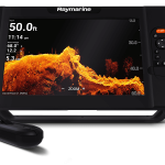
Raymarine Axiom 7 – 7″ Touch Screen Multifunction Navigation with integrated RealVision 3D, 600W Sonar with RV-100 transducer and AUS Mapping [Part Number #E70365-03-AUS]
-30% Marine Electronics, Sounders
Raymarine Axiom 7 – 7″ Touch Screen Multifunction Navigation with integrated RealVision 3D, 600W Sonar with RV-100 transducer and AUS Mapping [Part Number #E70365-03-AUS]
### RAYMARINE AXIOM SALE – ONLY WHILE STOCKS LAST ###
BLAZING FAST PERFORMANCE AND POWER
AT YOUR FINGER TIPSRaymarine Axiom 7 RealVision Multifunction Display is a powerful new Navigation system, delivering exceptional fish-finding performance. Complete with built-in RealVision 3D Sonar, all new LightHouse 3 operating system and fast quad core processor, Axiom puts you in complete control.
RealVision 3D is an all-in-one Transducer that combines CHIRP DownVision, SideVision, High Frequency CHIRP, and RealVision 3D – giving you the ability to see what’s below, behind, and to the sides of the Boat, all at once and in 3D. You can pan, tilt and zoom the 3D image to examine from any angle. Additionally, Raymarine’s gyro-stabilized Sonar technology compensates for Boat movement.
The new LightHouse 3 OS delivers an intuitive and powerful Navigation experience through a redesigned interface that is quick to learn and easy to personalise. Its LiveView Menu Controls allow users to easily customise the Chart and see the Navigation display changes in real time.
Axiom is expandable, so its capabilities can grow as needed. It supports the full range of Raymarine accessories, including Quantum radar, CHIRP Sonar, FLIR thermal cameras, audio integration, instruments, cameras, and Evolution autopilot. Standard Wi-Fi and Bluetooth connectivity allows connection to the latest Raymarine apps for tablets and smartphones.
DISPLAY
Display Size 7.0″ Optically Bonded LCD
Display Resolution 800 x 480 WVGA
Display Type Multitouch
Brightness 1,200 nits
Viewing Angle Degrees: 60 / 70 / 70 / 70 (Top / Bottom / Left / Right)PHYSICAL
Dimensions 210 x 142 x 77mm (7.92″ x 5.24″ x 3.00″)
Weight 1.52kg (3.35lbs)
Mounting Top, Flush, Front, Bracket
Waterproof Rating IPX6 / IPX7
Operating Temperature -25deg C to +55deg C (-13deg F to 131deg F)
Storage Temp -30deg C to +70deg C (- 22deg F to 158deg F)POWER
Voltage 12V DC (8 V to 16 VDC)
Power Consumption (Full brightness) TBD
Power Consumption (Powersave Mode) TBDNAVIGATION
Cartography Lighthouse, Navionics, *C-MAP Essentials & *C-MAP 4D MAX+
[*C-MAP chart compatibility available in future Lighthouse 3 software update]
Find out more about our cartography options
Tides & Currents Requires Navionics or *C-MAP
Waypoint / Routes / Tracks 10,000 wpts / 200 wpt groups / 150 rts – 250 wpt max / 16 tracks – 10,000 max trk ptsMEMORY
Internal 4GB Solid State
External 1 x microSD slots (rear) – microSDHC max 32GB NTFS or FAT32 format / microSDXC max 2TB NTFS or FAT32 format (microSD native format of exFAT must be reformatted to NTFS or FAT32)OTHER
Languages 14
Conformances NMEA 2000 certification: Europe: 1999/5/EC | Australia and New Zealand: C-Tick, Compliance Level 2 | FCC 47CFR part 15 | Industry Canada RSS2102. RealVision 3D Transducers combine CHIRP DownVision, CHIRP SideVision, High Frequency CHIRP, and RealVision 3D into a single transducer housing.
Raymarine’s RV-100 All-In-One Transom Mount Transducer lets you easily identify structures and locate fish with the lifelike clarity of RealVision 3D sonar.
The RV-100 is designed for easy transom mounting on outboard-powered boats. It features a rugged, marine-grade stainless steel mounting bracket with integrated kick-up to prevent damage in the event of a strike with floating debris, rocks, or stumps.
The RV-100 can also be removed from the transom bracket and attached to the stainless jack-plate mounting bracket (sold separately) which is ideal for bass boats, flats boats and skiffs. The RV-100 can also be mounted onto stepped hull vessels using the optional stainless steel step mounting bracket (sold separately).
3. Navionics Gold Marine Charts
Navionics Gold Charts can take you where you want to go. Whether you are on the water or planning a trip. Newly released Navionics XL9 marine Chart provides detailed charts for ALL of Australian coastline on one card! New Navionics+ maps explained.
Navionics Marine Charts offer:
SonarChart Live support for Compatible Lowrance/Simrad/Raymarine/Humminbird displays
Familiar Paper Chart Appearance with Both Fishing & Cruising detail!
New Small Coverage
Regular updates with Navionics Community Data (conditions apply)
Intelligent Clarity IC™ Provides A Clear And Uncluttered Display. Easy To Read At All Zoom Levels.
Superb Detail Navaids With XPlain, Tides & Currents, Shaded Contours, Spot Soundings.
Plug & Play Cartridge Preprogrammed and hassle-free! No CD’s or Downloads Required!
Full Seamless Technology. No Clutter. No Holes. No Discontinuities.SKU: E70635-03-AUS -
Marine Electronics, Sounders, Uncategorised
Raymarine Element 7 – 7″ Multi-function Navigation with integrated 3D and Australia Wide Mapping
 Marine Electronics, Sounders, Uncategorised
Raymarine Element 7 – 7″ Multi-function Navigation with integrated 3D and Australia Wide Mapping
Raymarine Element 7 – 7″ Multi-function Navigation with integrated 3D and Australia Wide Mapping
Click Here to read our article of the new Raymarine Element from our testings with the new model.
FISH SMARTER – ABOVE AND BELOW THE WATERLINE
Knowledge is power—and the Element™ CHIRP Sonar / GPS series from Raymarine gives you the upper hand when hunting for fish and their habitat. Delivering the sharpest view of the underwater world, Element’s HyperVision™ 1.2 megahertz sonar technology, turns up the resolution of DownVision, SideVision, and RealVision 3D to a new level of precision imaging and fish identification, letting you see structures, vegetation, and fish with amazing life-like clarity.
MODEL Element 7 HV Element 9 HV Element 12 HV SENSORS
GNSS / GPS Built-in GNSS Receiver: GPS/GLONASS Sonar Type (Built-in) Built-in CHIRP Sonar, DownVision (Standard and Hyper), SideVision (Standard and Hyper), RealVision™ 3D (Standard and Hyper) Sonar Connection 15 pin HyperVision™ type connector Sonar Depth CHIRP Sonar = 274m (900 feet)
DownVision™ Standard = 183m (600 feet) | DownVision™ Hyper = 30m (100 feet)
SideVision™ Standard = 91m (300 feet) | SideVision™ Hyper = 30m (100 feet)
RealVision™ 3D Standard = 91m (300 feet) | RealVision™ 3D Hyper = 30m (100 feet)NETWORKING
Ethernet N/A NMEA0183 N/A NMEA2000 1 x NMEA2000 port (DeviceNet microC) Supported NMEA2000 Networking INPUT: NMEA2000 Compatible Engines (Max 2) | NMEA2000 Compatible Tank Sensors (Max 4) | Heading Sensor (for Chart Stabilization)
OUTPUT: GPS (for VHF Distress and DSC)SeaTalkng Requires A06045 DeviceNet female (F) adapter cable – 400mm USB N/A Wi-Fi WiFi – 802.11 b / g / n BlueTooth Bluetooth 4.0 + Low Energy + Power Class 1.5 OTHER SPECIFICATIONS
Cartography Raymarine LightHouse NC2, Navionics, C-MAP Essentials, C-MAP 4D MAX+, and compatible with all charts listed on Raymarine Chart Store. Tides & Currents Requires LightHouse LNC2, Navionics or C-MAP Waypoint / Routes / Tracks 10,000 wpts / 200 wpt groups / 150 rts – 250 wpt max / 16 tracks – 10,000 max trk pts Internal Memory 8GB Solid State External Memory 1 x microSD slots – microSDHC max 32GB NTFS or FAT32 format / microSDXC max 2TB NTFS or FAT32 format (microSD native format of exFAT must be reformatted to NTFS or FAT32) 3. Navionics Gold Marine Charts
Navionics Gold Charts can take you where you want to go. Whether you are on the water or planning a trip. Newly released Navionics XL9 marine Chart provides detailed charts for ALL of Australian coastline on one card! New Navionics+ maps explained.
Navionics Marine Charts offer:
SonarChart Live support for Compatible Lowrance/Simrad/Raymarine/Humminbird displays
Familiar Paper Chart Appearance with Both Fishing & Cruising detail!
New Small Coverage
Regular updates with Navionics Community Data (conditions apply)
Intelligent Clarity IC™ Provides A Clear And Uncluttered Display. Easy To Read At All Zoom Levels.
Superb Detail Navaids With XPlain, Tides & Currents, Shaded Contours, Spot Soundings.
Plug & Play Cartridge Preprogrammed and hassle-free! No CD’s or Downloads Required!
Full Seamless Technology. No Clutter. No Holes. No Discontinuities.SKU: E70532-05-AUS -
Marine Electronics, Sounders
Raymarine Element 12 – 12″ Multi-function Navigation with integrated 3D and Australia Wide Mapping
Marine Electronics, SoundersRaymarine Element 12 – 12″ Multi-function Navigation with integrated 3D and Australia Wide Mapping
Raymarine Element 12 – 12″ Multi-function Navigation with integrated 3D and Australia Wide Mapping
Click Here to read our article of the new Raymarine Element from our testings with the new model.
NEW Element – Sonar / GPS Combo | Raymarine by FLIR
FISH SMARTER – ABOVE AND BELOW THE WATERLINE
Knowledge is power—and the Element™ CHIRP Sonar / GPS series from Raymarine gives you the upper hand when hunting for fish and their habitat. Delivering the sharpest view of the underwater world, Element’s HyperVision™ 1.2 megahertz sonar technology, turns up the resolution of DownVision, SideVision, and RealVision 3D to a new level of precision imaging and fish identification, letting you see structures, vegetation, and fish with amazing life-like clarity.
MODEL Element 7 HV Element 9 HV Element 12 HV SENSORS
GNSS / GPS Built-in GNSS Receiver: GPS/GLONASS Sonar Type (Built-in) Built-in CHIRP Sonar, DownVision (Standard and Hyper), SideVision (Standard and Hyper), RealVision™ 3D (Standard and Hyper) Sonar Connection 15 pin HyperVision™ type connector Sonar Depth CHIRP Sonar = 274m (900 feet)
DownVision™ Standard = 183m (600 feet) | DownVision™ Hyper = 30m (100 feet)
SideVision™ Standard = 91m (300 feet) | SideVision™ Hyper = 30m (100 feet)
RealVision™ 3D Standard = 91m (300 feet) | RealVision™ 3D Hyper = 30m (100 feet)NETWORKING
Ethernet N/A NMEA0183 N/A NMEA2000 1 x NMEA2000 port (DeviceNet microC) Supported NMEA2000 Networking INPUT: NMEA2000 Compatible Engines (Max 2) | NMEA2000 Compatible Tank Sensors (Max 4) | Heading Sensor (for Chart Stabilization)
OUTPUT: GPS (for VHF Distress and DSC)SeaTalkng Requires A06045 DeviceNet female (F) adapter cable – 400mm USB N/A Wi-Fi WiFi – 802.11 b / g / n BlueTooth Bluetooth 4.0 + Low Energy + Power Class 1.5 OTHER SPECIFICATIONS
Cartography Raymarine LightHouse NC2, Navionics, C-MAP Essentials, C-MAP 4D MAX+, and compatible with all charts listed on Raymarine Chart Store. Tides & Currents Requires LightHouse LNC2, Navionics or C-MAP Waypoint / Routes / Tracks 10,000 wpts / 200 wpt groups / 150 rts – 250 wpt max / 16 tracks – 10,000 max trk pts Internal Memory 8GB Solid State External Memory 1 x microSD slots – microSDHC max 32GB NTFS or FAT32 format / microSDXC max 2TB NTFS or FAT32 format (microSD native format of exFAT must be reformatted to NTFS or FAT32) 3. Navionics Gold Marine Charts
Navionics Gold Charts can take you where you want to go. Whether you are on the water or planning a trip. Newly released Navionics XL9 marine Chart provides detailed charts for ALL of Australian coastline on one card! New Navionics+ maps explained.
Navionics Marine Charts offer:
SonarChart Live support for Compatible Lowrance/Simrad/Raymarine/Humminbird displays
Familiar Paper Chart Appearance with Both Fishing & Cruising detail!
New Small Coverage
Regular updates with Navionics Community Data (conditions apply)
Intelligent Clarity IC™ Provides A Clear And Uncluttered Display. Easy To Read At All Zoom Levels.
Superb Detail Navaids With XPlain, Tides & Currents, Shaded Contours, Spot Soundings.
Plug & Play Cartridge Preprogrammed and hassle-free! No CD’s or Downloads Required!
Full Seamless Technology. No Clutter. No Holes. No Discontinuities.SKU: E70536-05-AUS